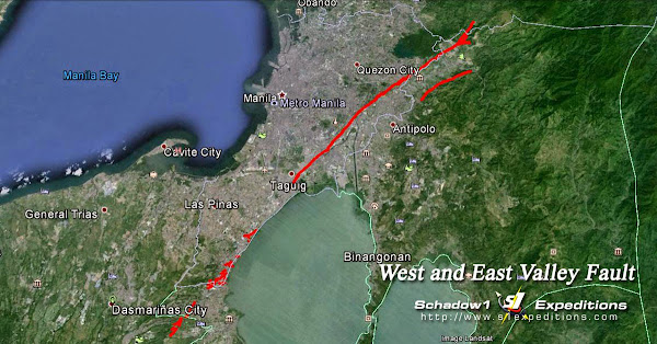
Interactive Map for the West and East Valley Fault Line on Rizal, Metro Manila, Laguna, Cavite
7,792 views
Skip to first unread message
Dwight Galsim
May 16, 2015, 7:23:28 PM5/16/15
to
Friday, July 11, 2014
Interactive Map for the West and East Valley Fault Line on Rizal, Metro Manila, Laguna, Cavite
We have recently acquired the fault line data for the West and East Valley Fault System from PHIVOLCS and have decided to trace the data on top of Openstreetmap Philippines and on Google Earth. This is to provide a graphical representation of the exact infrastructures that lies on top of the fault line so that everyone will be aware of the dangers and prepare for the future.
The last known activity along this fault line was the year 1658 and is estimated to be active every 300 years plus or minus 100 years. As of the time of this writing, it has been 356 years ago and is well within the potential period of its movement.
The photo above is a snapshot along the area of Muntinlupa and San Pedro, Laguna where the red line is a part of the West Valley Fault Line.
We have prepared a trace of the fault line over Google Earth and can be downloaded here.
 |
| Downloadable Interactive Map of the West and East Valley Fault Line |
These are the following notable barangays, villages and infrastructure that lie exactly on top or within 500-meter radius from the fault line.
- Southville Montalban
- Kasiglahan Village, Montalban
- Litex Textile Mills, Montalban
- Dulong Bayan 2, San Mateo Rizal
- Santo Nino, San Mateo Rizal
- Bagong Silangan Quezon City
- Sunnyside Heights Subdivision, Quezon City
- Batasan Hills
- Kasiglahan Village
- Tagumpay Elementary School
- San Isidro, Marikina
- Santa Elena Markina
- Loyola Grand Villas
- Ateneo De Manila University
- Barangka
- Industrial Valley
- Blue Ridge
- Libis
- J.M. Basa Compound
- White Plains, QC
- Valle Verde
- Ugong
- West Rembo
- East Rembo
- Comembo
- Aguho
- Rizal
- Cypress Towers
- Pinagsama
- South Signal Village
- Amkor Anam, Cupang, Muntinlupa
- Alabang Hills
- Bayanan, Muntinlupa
- Lake View Homes 1 and 2, Muntinlupa
- Midland Subdivision
- Gruenville Subdivision
- New Rain Subdivision
- Muntinlupa City Hall
- Sto Nino Village
- Poblacion, Muntinlupa
- SM Muntinlupa
- Park Homes, Tunasan, Muntinlupa
- Villa Carolina, Tunasan, Muntinlupa
- La Marea
- Susana Heights
- Sampaguita Village
- Stonecrest San Pedro Laguna
- Rosario, San Pedro, Laguna
- Juana 3, Binan, Laguna
- Manila Southwoods Golf and Country Club, Binan, Laguna
- San Lazaro Leisure and Business Park, Carmona, Cavite
- Carmona Estates
- Canyon Ranch
- Moderno Homes
- DLSU Science and Technology Complex, Laguna
- Ayala Westgrove Heights
- Richland Hills Phase 1
- Adventist University of the Philippines, Laguna
- Canlubang Golf and Country Club
Sent from my iPad 
Reply all
Reply to author
Forward
0 new messages

