Issue creating Study Area layer and coverage
40 views
Skip to first unread message

aschi...@gmail.com
Mar 11, 2022, 3:16:32 PM3/11/22
to distance-sampling
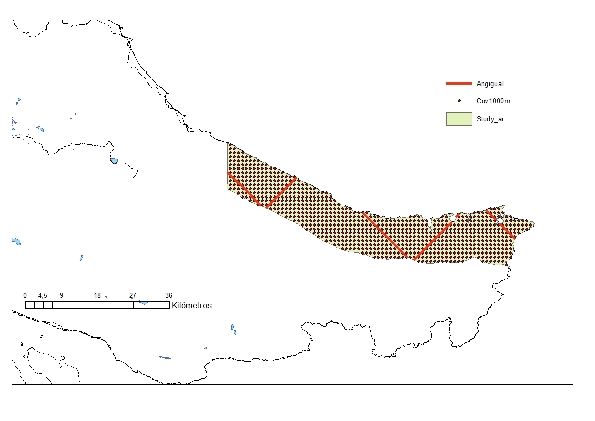
Hi everybody. I have issues when trying to create a coverage layer over a sudy area defined by a shapefile imported sucesfully with the shape import wizard.
Never had issues usually with previous versions of Distance.
The coverage layer is created completely out of line, with negative values.
I attach a compressed file with the project and the project folder, which includes the study area shapefile and the coverage generated using the common procedure in Distance.
Any help is welcome.

Eric Rexstad
Mar 12, 2022, 3:00:17 AM3/12/22
to aschi...@gmail.com, distance-sampling
Adrian
Thanks for reporting your problem. The University email system would not accept your attachment, but I could access it from the Google groups site.
The situation is just as you report it; coordinates of your shape file and coordinates of your coverage grid locations carry opposite signs. Not very useful for computing evenness of competing survey designs.
Two (possibly random) ideas:
I see the shapefile name inside the Bagual_PM.dat subdirectory is not "Study_ar.shp", but rather "Costa_PM.shp". I was of the belief that shape files needed to have that specific name; perhaps my understanding is outdated.
Is there any chance the coordinates of the shape file could have been in the "wrong" order; clockwise rather than counter-clockwise (or whichever direction is expected of shape files)?
From: distance...@googlegroups.com <distance...@googlegroups.com> on behalf of aschi...@gmail.com <aschi...@gmail.com>
Sent: 11 March 2022 20:16
To: distance-sampling <distance...@googlegroups.com>
Subject: {Suspected Spam} {Filename?} [distance-sampling] Issue creating Study Area layer and coverage
Sent: 11 March 2022 20:16
To: distance-sampling <distance...@googlegroups.com>
Subject: {Suspected Spam} {Filename?} [distance-sampling] Issue creating Study Area layer and coverage
--
You received this message because you are subscribed to the Google Groups "distance-sampling" group.
To unsubscribe from this group and stop receiving emails from it, send an email to distance-sampl...@googlegroups.com.
To view this discussion on the web visit https://groups.google.com/d/msgid/distance-sampling/6240f8e9-9320-40c7-b44c-efaf775a5ebfn%40googlegroups.com.
aschi...@gmail.com
Mar 12, 2022, 11:16:38 AM3/12/22
to distance-sampling
Hi Eric thanks
I tried import the shapefile but it doesn´t works.
Then I was able to build the Study Area copying and pasting the vertices of the polygon, without geographic reference.
Study Area builds OK. The coverage was created OK and can be loaded in ArcGis correctly drawn.
After that simulated designs, equal spaced zigzag. Everything Ok, with different zizgzag spacing.
Simulated a survey and Ok, even loaded the survey in ArcGis right way.
So for survey planning purposes and evaluation, all seems OK without using the import shapefile facility. Maybe I am doing something wrong in the import process...
I attach a figure from ArcGis where you can see that Distance output (Study area, coverage and survey ) holds the right coordinates at the end.
Besides, I tried to simulate an equal angle zigzag, and Distance hangs (although this is reported in the reference guide)
Just to keep you informed in any case there is an issue.
I installed 7.4 yesterday. I tried uninstall and reinstall and the behavior is the same.
I can try to do it in another computer whan I return from the field, to verify that there is nothing to do with my computer.
Eric Rexstad
Mar 13, 2022, 3:43:36 AM3/13/22
to aschi...@gmail.com, distance-sampling
Thanks for the report Adrian. We will investigate.
From: distance...@googlegroups.com <distance...@googlegroups.com> on behalf of aschi...@gmail.com <aschi...@gmail.com>
Sent: 12 March 2022 16:16
To: distance-sampling <distance...@googlegroups.com>
Subject: {Suspected Spam} Re: {Suspected Spam} {Filename?} [distance-sampling] Issue creating Study Area layer and coverage
To: distance-sampling <distance...@googlegroups.com>
Subject: {Suspected Spam} Re: {Suspected Spam} {Filename?} [distance-sampling] Issue creating Study Area layer and coverage
To view this discussion on the web visit
https://groups.google.com/d/msgid/distance-sampling/600e79fa-3d2a-4d90-8a80-68d1cf643a11n%40googlegroups.com.

l_h_marshall
Mar 31, 2022, 6:18:57 AM3/31/22
to distance-sampling
Hi Adrian,
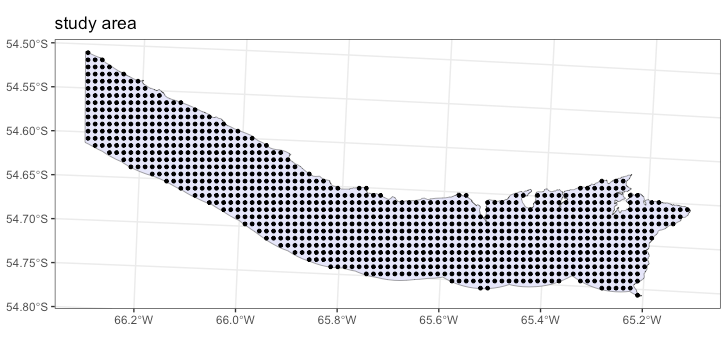
I've had a look into this and I think it was something to do with your projection file (.prj) but I'm not entirely sure what... Distance has some issue with it. When you say the import shapefile didn't work for you what went wrong? When I imported it looked like it had worked and displayed fine but the coverage grid again had the strange negative values.
I then ran a second import in a new project but this time I removed the .prj file from the folder with the rest of the shapefile in. As the shape was already projected Distance doesn't really need to know the specifics of the projection just the units. When I imported this time and said to go ahead and create the coverage grid everything worked fine and the coverage grid coordinates were correct. Your method of copying and pasting the coordinates in would also have bypassed the need for the .prj file so that is consistent with your findings.
Next, I tried our old import method of creating a new geographic project and then copying the shapefiles over the top of the default ones and then manually setting the default project projection to be the same as the shapefile. Again including the .prj file caused the same issues with the coverage grid coordinates not being contained in the study region.
Finally, I tried using our R package dsims and it is quite happy to turn your projected region with all the projection information into a Region object and correctly creates the coverage grid over the top.
I'm going to add this in our bug repository so that others can figure out the work around. This appears to be a projection issue which is unlikely to be easily fixed inside Distance unfortunately. The shapefile import seems to be performing it's steps in line with what I would expect.
Hope that is of some help,
Best wishes,
Laura
Reply all
Reply to author
Forward
0 new messages