Deriving Lot Frontage from Parcel Data
164 views
Skip to first unread message

Sean
Oct 7, 2015, 4:56:00 PM10/7/15
to DataTO
Hi there, I have been using the OpenData sets quite extensively lately for various projects and have run into a hurdle. I am trying to derive the frontage for each parcel in set areas (starting will smaller study areas, hope to implement a set City-wide), but am unsure of how to approach the task.
Most parcel data that I am familiar with, the right-of-ways for streets are simply negative space (IIRC York Region Parcel data is set up this way). This allows one through various geoprocessing finagling to populate an an attribute table with a frontage dimension for each polygon (based on the fact that the frontage would be the only part of the polygon that is not in contact with another polygon). The hurdle I have run into is that the COT Parcel data has polygons for right of ways which must be removed. On my smaller study area scale this wasn't an issue really, I would just delete the street and road parcels manually. However with a larger scale implementation of this on a City-wide scale, obviously that is not an option.
I have tried using the Ontario Road Network data (clipped to the COT boundary) to select only parcels intersecting with roadways, and delete them. This causes my computer to crash every time, and I have not been able to get anywhere with this.
Am I going about this in the wrong way or is there a simpler way out there to achieve what I am after? I have already populated the attribute table for the parcels with items like lot coverage (from the bldg footprint data) and lot area but I am banging my head against the wall trying to get the frontage measurements in bulk. Ideally I would like to be able to select an area via polygon or radius, and generate a list of lot frontages for selected area.
Any tips? I am using the latest 2.10 QGIS and GRASS packages.
Thanks,
Sean

Marcel Fortin
Oct 7, 2015, 5:13:39 PM10/7/15
to dat...@googlegroups.com
Hi Sean,
Is there a way you could send a screen cap or a drawing of what this should look like? I am having a hard time visualizing what you mean.
Marcel Fortin
GIS and Map Librarian
Head, Map and Data Library
University of Toronto
Is there a way you could send a screen cap or a drawing of what this should look like? I am having a hard time visualizing what you mean.
Marcel Fortin
GIS and Map Librarian
Head, Map and Data Library
University of Toronto
--
---
You received this message because you are subscribed to the Google Groups "DataTO" group.
To unsubscribe from this group and stop receiving emails from it, send an email to datato+un...@googlegroups.com.
For more options, visit https://groups.google.com/d/optout.

Sandy Ward
Oct 8, 2015, 4:07:55 AM10/8/15
to dat...@googlegroups.com
Sean,
Might be no help, just if the data is loaded into a Postgre DB with PostGIS you can easily run a query to get the ID of all the polygons that intersect. His could give you what you are looking for...if useful let me know happy to help and share sample code.
Sandy
Sent from my iPhone
--
sean
Oct 8, 2015, 7:48:47 AM10/8/15
to DataTO
Hi Marcel,
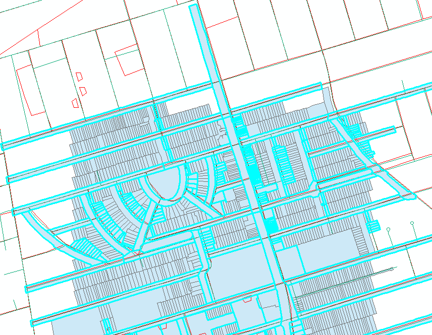
Here is a screencap of the York Region parcel data from their Open Data program (http://imgur.com/Y42FwHY). As you can see, the right of ways for streets, roads etc are not represented as polygons, but rather just negative space with no data. Therefore lot frontage can be derived by measuring the sides of the polygons that are not touching another polygon. In the City of Toronto dataset, the right of ways are represented as polygons. I am trying to figure out a way to delete all these right of way polygons and end up with a parcel dataset similar to York Region's. I tried overlaying the road network and running a selection on the parcel layer polygons that intersect the road network, but I just can't get it to work.
Thanks,
Sean
Marcel Fortin
Oct 8, 2015, 12:14:14 PM10/8/15
to dat...@googlegroups.com
I see. I just tried loading the census block boundaries and with the
toronto centreline data and had some good success doing a selection
using the "crossed by the outline of the source layer feature"
option Location search in ArcGIS. The problem in doing this though
is that the centreline layer and the property boundaries layers
don't match up properly. If they were truly centred on the polygons,
this would work quite well. In looking at other road network layers
from DMTI, as well as the Teranet parcels I can see that the problem
is with the parcel boundaries, not the roads. So shifting the
boundaries may be an option. But this may of course lead to more
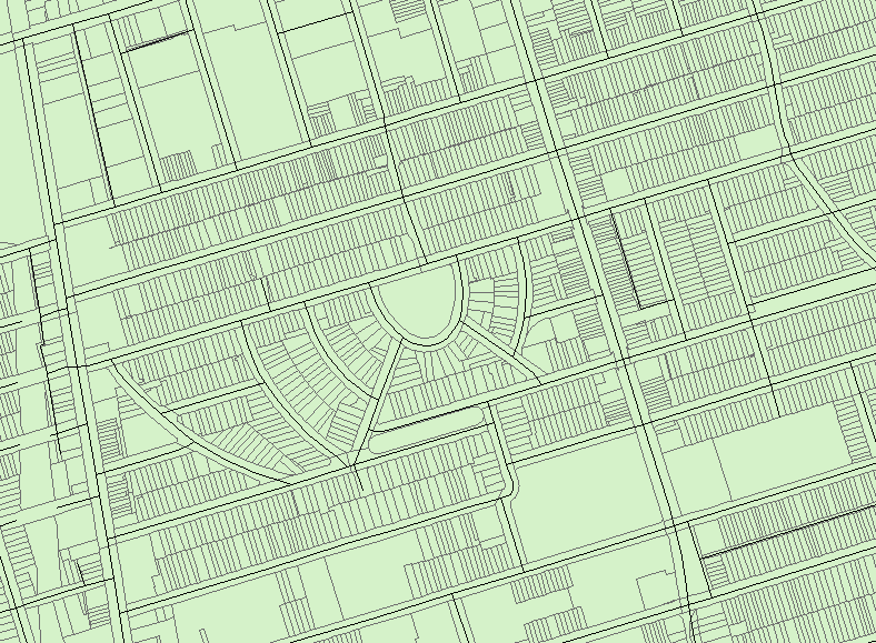
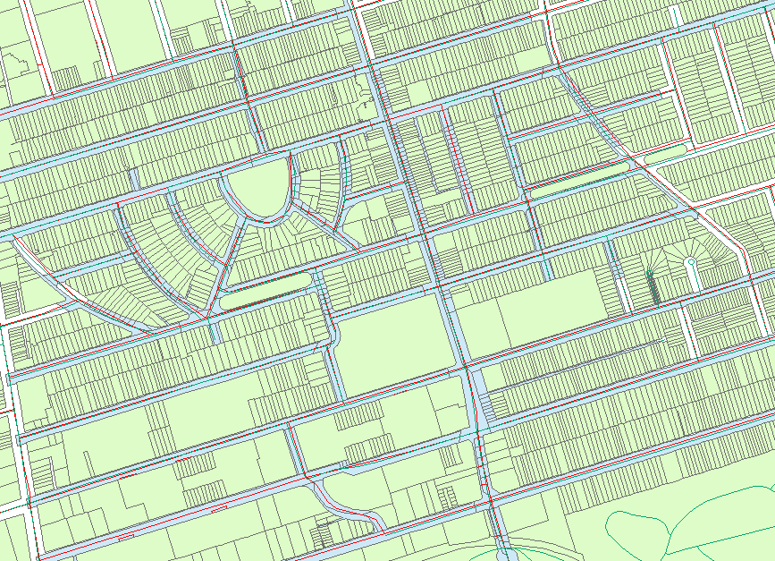
issues. This image below is of a selection as above. You can see
that if the roads crossed only the centreline and not through the
parcels, your query would return just the polygons that the roads
cross. The second image is what that should look like.
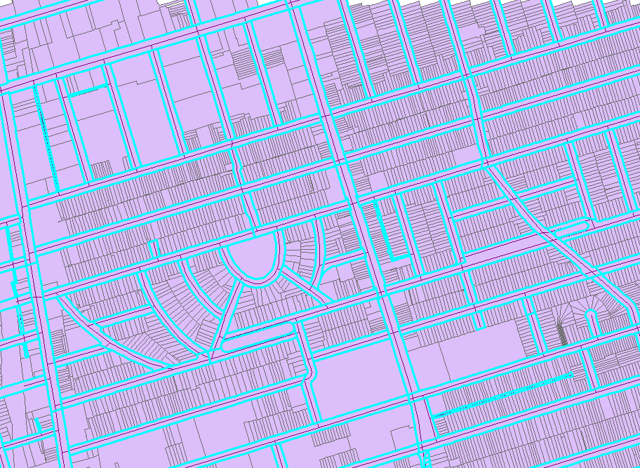
I wonder if the city has Teranet-type assessment parcels instead of the ownership parcels. Teranet has both. The assessment boundaries don't have a polygon for the roads the way the open dataset has. See the attached image below where I have overlayed the Teranet parcels on top of the city's open data parcels. The green are the Teranet parcels and in blue, underneath, are the open data parcels you are using.
Sorry I can't be more help. And I wish I could provide you with these parcels, but they are for UofT research and teaching only.
Marcel
--
Marcel Fortin
Head, Map and Data Library
University of Toronto
@mapsgis
Marcel Fortin
Oct 8, 2015, 12:20:24 PM10/8/15
to dat...@googlegroups.com
Here is what the same selection of polygons looks like when the
roads and the parcels match up. You can see that the only polygons
picked up in the selection are the road polygons.
On 10/8/2015 12:13 PM, Marcel Fortin
wrote:
I see. I just tried loading the census block boundaries and with the toronto centreline data and had some good success doing a selection using the "crossed by the outline of the source layer feature" option Location search in ArcGIS. The problem in doing this though is that the centreline layer and the property boundaries layers don't match up properly. If they were truly centred on the polygons, this would work quite well. In looking at other road network layers from DMTI, as well as the Teranet parcels I can see that the problem is with the parcel boundaries, not the roads. So shifting the boundaries may be an option. But this may of course lead to more issues. This image below is of a selection as above. You can see that if the roads crossed only the centreline and not through the parcels, your query would return just the polygons that the roads cross. The second image is what that should look like.
I wonder if the city has Teranet-type assessment parcels instead of the ownership parcels. Teranet has both. The assessment boundaries don't have a polygon for the roads the way the open dataset has. See the attached image below where I have overlayed the Teranet parcels on top of the city's open data parcels. The green are the Teranet parcels and in blue, underneath, are the open data parcels you are using.
Sorry I can't be more help. And I wish I could provide you with these parcels, but they are for UofT research and teaching only.
Marcel

Keith McDonald COT Open Data Lead
Oct 8, 2015, 12:27:33 PM10/8/15
to DataTO
Hi all ... I have asked our mappers to have a look here and hoping they will weigh in soon on this.
Keith

Stewart Russell
Oct 8, 2015, 2:10:50 PM10/8/15
to dat...@googlegroups.com
Hi Marcel,
Even though the Teranet parcels are official and expensive (and very very closed licensing), my experience from rural infrastructure design also says they are rarely accurate. My former employer used to have to use an OLS to survey parcels and correct Teranet's polygons.
Stewart
Marcel Fortin
Oct 8, 2015, 2:39:46 PM10/8/15
to dat...@googlegroups.com
Hi Stewart,
True enough, but at the same time, their parcels do work together much more tightly with the road network than the city's parcels do. For Sean's purposes, they would probably be better. As well, Sean's study is in the city and they may be more accurate than in rural areas of the province.
Marcel
True enough, but at the same time, their parcels do work together much more tightly with the road network than the city's parcels do. For Sean's purposes, they would probably be better. As well, Sean's study is in the city and they may be more accurate than in rural areas of the province.
Marcel
--
---
You received this message because you are subscribed to the Google Groups "DataTO" group.
To unsubscribe from this group and stop receiving emails from it, send an email to datato+un...@googlegroups.com.
For more options, visit https://groups.google.com/d/optout.
sean
Dec 2, 2015, 10:59:31 AM12/2/15
to DataTO
Just wanted to give an update to this. I have found a cheater work around so far that I have been using. Its not exactly the most graphically pleasing method, but for researching lot frontages it is adequate.
Basically I took the York Region parcel layer (I have not yet tried this with the COT data) and exploded the polygons to individual line segments. Then I label this layer with $length to display the frontage for each lot. It's not perfect- if the lot has a vertex in the frontage lot line, then two dimensions are are displayed, one for each segment. This also ends up labeling the side and rear lot lines as well, but that's okay. So far it is adequate for what I need, but I plan to keep working towards something that is more efficient/graphically presentable.
Thanks everyone for the assistance.
Keith McDonald COT Open Data Lead
Dec 18, 2015, 3:19:58 PM12/18/15
to DataTO
We're gearing up a tools and help page that we'd like to see be as comprehensive as possible to mitigate issues with our data sets.
This could include work arounds as well as helpful tools to use - how to open files - whatever would be useful!!!!! We really want to crowd source this!!!!
You could provide links to your own content at a website or send us some content to add to our page. This will be a living and breathing page that can grow as much as it needs to grow.
We are no where near having a platform to publish that would have tools built into it. So, it's going to be our current content management tool that we must use. We can't enable social media features to these pages. So, we really need you to reach out to us and we can figure out how best to present the "help".
The link to what we have just posted: http://www1.toronto.ca/wps/portal/contentonly?vgnextoid=052c2d9ae1d81510VgnVCM10000071d60f89RCRD
All the best through the holiday season! May 2016 rock the socks off open data here in Toronto!!!!!!
Keith
Reply all
Reply to author
Forward
0 new messages