Delhi draft DP pdf turned into a map (and you can do it too)
265 views
Skip to first unread message

Nikhil VJ
Jul 12, 2021, 11:11:14 PM7/12/21
to datameet
Hi All,
Sharing about a recent collaboration I did with Rajesvari Parasa to turn a development plan PDF into an web based interactive map. Spinoffs from here may be useful to the data community.
Here's the output:
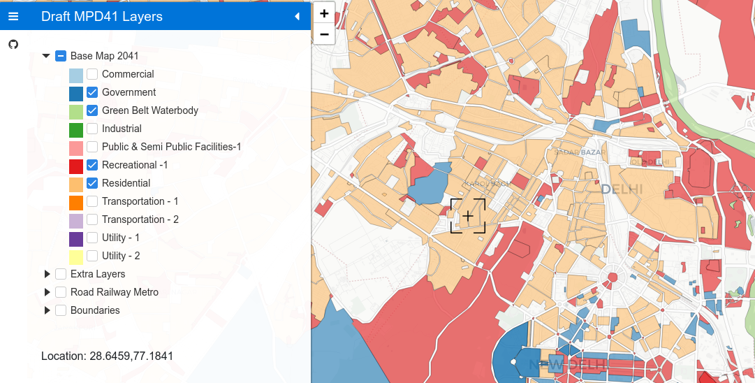
Sharing what went into it:
1. Extracting from PDF
- It's one of those PDFs exported from Autocad or so where you can see multi-layers and turn them on or off.
- Rajesvari used a command-line GIS tool called "ogr2ogr" to extract individual layers from the PDF into .geojson shapefiles.
- There was a tricky bit where the output lat-longs were all like (716882.20,3166456.28) - a different CRS and we didn't know which.
- I used http://projfinder.com/ to find it, then Rajesvari included CRS conversion into the ogr2ogr commands to produce proper shapefiles.
- You can see all that in this repo: https://github.com/draftmpd41/layers_draft_delhi_master_plan_2041 - see the .bat file for the ogr2ogr commands
2. Poor person's GIS system
- I cobbled together a static website (html + vanilla javascript) that mimics those geoserver-driven multiple-layers-groups sites like we see at Bhuvan and various municipal corporations' GIS portals.
- Parameterised the whole thing: By editing a small JS file and CSV table, you can repurpose this to make it yours.
- The site is static, as in: no backend. Can run it anywhere.
- Loads layers only when user clicks on them first time. So, site loads quickly even if data is heavy.
- Disclaimer: if you don't want your site visitors grabbing all the data, then please go the geoserver way. This one's for open sharing (F12 > Network > XHR)
3. Developed but not deployed: Citizens inputs layer
- Here, I added in a citizens' inputs form to capture geo-located comments. The comments go to a backend program where they're saved in a basic MySQL DB.
- We haven't activated this because there aren't any people on board to admin the thing (moderation, spam prevention etc - nightmare).
- But the setup is simple and can be useful for others who want to do this, so sharing it.
- Frontend with additional section and inputs layer: https://github.com/draftmpd41/frontend-with-inputs
- Backend code: https://github.com/draftmpd41/draftmpd41_backend (in python3)
- It's setup such that frontend and backend can be hosted separately.
- Disclaimer. It's simple and basic. No user accounts or spam prevention. Moderation would have to be through phpMyAdmin on the backend server.

Naraina Damle
Jul 15, 2021, 2:29:28 PM7/15/21
to datameet
GOOD

Arun Ganesh
Jul 15, 2021, 2:51:27 PM7/15/21
to datameet
This is fantastic work Nikhil! Love how it's parametrized for easy configuration.
The backend part for citizen inputs is especially interesting and would really complete the whole loop for so many such geospatial applications. The moderation of such content is definitely a pain and something i keep thinking about. It may be helpful just to have it hosted as a demo for the platform.
--
Datameet is a community of Data Science enthusiasts in India. Know more about us by visiting http://datameet.org
---
You received this message because you are subscribed to the Google Groups "datameet" group.
To unsubscribe from this group and stop receiving emails from it, send an email to datameet+u...@googlegroups.com.
To view this discussion on the web visit https://groups.google.com/d/msgid/datameet/c8e88b31-be2a-4f38-be51-f9ab91b07f6fn%40googlegroups.com.

Cara Foss Arellano
Jul 17, 2021, 9:41:10 AM7/17/21
to data...@googlegroups.com
BRILLIANT
--
Datameet is a community of Data Science enthusiasts in India. Know more about us by visiting http://datameet.org
---
You received this message because you are subscribed to the Google Groups "datameet" group.
To unsubscribe from this group and stop receiving emails from it, send an email to datameet+u...@googlegroups.com.
To view this discussion on the web visit https://groups.google.com/d/msgid/datameet/CAH7jeuO9FPhfgNCMvBgAhqaw-74CNAkKRjNpDV3Me6TXzSHsYw%40mail.gmail.com.
Cara Foss Arellano

Ganesh Babu
Jul 17, 2021, 9:42:30 AM7/17/21
to data...@googlegroups.com
This is a very important missing part in the existing information dissemination and feedback collection components of master plan development in Indian cities. I am planning to try something similar for Chennai when they eventually release master plan 3.0
In case you aren't aware, a bunch of like-minded non-governmental organisations are working on a campaign called Main Bhi Dilli to make planning in Delhi more representative and inclusive by engaging citizens in the 2041 Master Plan process. I think your online tool can be a valuable component of their efforts too. Potentially their combined resources can help tackle some of the issues you raised in the input collection component. Their contact information is on the website, in case you can't reach them, I can put you in touch with one of the organisers if you are interested.
Fantastic work again!
To view this discussion on the web visit https://groups.google.com/d/msgid/datameet/CA%2BGKQr2EoJR0hHfOM934YfLpsYAuYsH7s9LbpdhkvE9aezG6cA%40mail.gmail.com.
Thanks and regards,
Ganesh Babu R P
+31 0 645 02 44 16
+31 0 645 02 44 16


Ujaval Gandhi
Jul 17, 2021, 3:22:40 PM7/17/21
to data...@googlegroups.com
Nikhil and Rajeswari - really impressive work! Thanks for sharing the process for GeoPDF extraction and hosting them on a nice static map. Will definitely be pointing people to your repo.
| ||||||
To view this discussion on the web visit https://groups.google.com/d/msgid/datameet/CAHjXGvTyki3j2Y22hUit0oK7Sjhukb5OrkNphG%3DRjGMbLQf3xA%40mail.gmail.com.
Nikhil VJ
Aug 1, 2021, 11:39:59 AM8/1/21
to datameet
Hi All,
Thanks for the +1s.
Got an input about making it printable. So, did it.
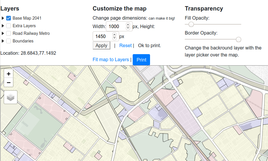
Click the print icon on left sidebar to open a page where you can adjust various settings and take a printout.
Only the map portion will be printed. You can increase the
height/width pixels and then print to A0/A1/A2 size etc to take large
high-res prints. (and I have no idea what setting makes the perfect print, if you find out then pls share.)
Background tiles : I've used from leaflet providers. Pls lookup legalities yourself.
To view this discussion on the web visit https://groups.google.com/d/msgid/datameet/CALymcQD6psWVhaMJ6xL5EPMf4KKWyvniDvQ4qnBVQ5%3DyAgnweg%40mail.gmail.com.

Suvajit Sengupta
Aug 1, 2021, 12:24:27 PM8/1/21
to data...@googlegroups.com
Hi Nikhil,
This is super work!!
It can really speed up processes for capturing Citizen feedbacks on Master Plan. Always needs another specialised agency when Planning Authorities need to publish draft master plans for citizen inputs.
My learning - generating geojson/shp files using ogr2ogr tool. I was not aware of it.
Regards,
Suvajit
To view this discussion on the web visit https://groups.google.com/d/msgid/datameet/CAH7jeuMs7D5X2jPbQLNt3jc0R%2B%2BQiPWWd5PwvHJwz5HxPJox0w%40mail.gmail.com.

Anisha Garg
Jun 19, 2024, 6:00:28 PMJun 19
to datameet
Wow! This is amazing work! Thanks a lot! :D
I wanted to ask you if it is possible to make this plan for the previous master plans - 1962, 2001 and 2021 - as well? It can be a good way to analyse changes in proposed land use plans over years, how much has been achieved, factors for change in land use, and so on.
Looking forward to hearing from you! :)
Thank You
Warm Regards,
Anisha
Reply all
Reply to author
Forward
0 new messages