Custom maps calibration possibilities
86 views
Skip to first unread message

Jörn Brumme
Nov 28, 2021, 12:16:08 PM11/28/21
to custom-m...@googlegroups.com
Hallo
At first: I am very happy with your App. It runs easy and without problems.
My question is, would it be possible to add other possibilities to calibrate the maps?
Sometimes it would be nice to take GPS-coordinates created by the phone on a known point if you are out in the field without connection to the internet. Maybe you walk than 1 kilometer or so and than you can take a second GPS shot on another known point and the map is running.
Sometimes it would also be interesting to be able to enter the coordinates of a known point by hand.
Very many thanks for your good work!
Wish you a nice day
Jörn

Marko Teittinen
Nov 28, 2021, 4:34:08 PM11/28/21
to Jörn Brumme, Custom Maps users
Jörn,
I have been thinking about doing those things.
Adding an option to manually enter latitude and longitude for a map image point should not be very difficult to do. I just have not got around to adding it. But I'm sure I will eventually get around to it.
The option of using the current GPS location for a map image point coordinates is a bit more tricky to implement. It requires storing the incomplete map after the first point is selected until the user applies a second point. During the time between first and second point it probably would be good to be able to display the map, but the user might also want to put the phone away. And if the user switches to using other apps before adding the next point, there probably should be a way for the user to select the incomplete map which is not very useful for navigation before the second point is added. Right now that app only deals with completed maps that have at least two points selected to provide location, orientation, and scale of the map image. So that request is a usability challenge. I have some thoughts about it, and I think this would potentially be a very useful feature when a network connection is not available. But at the same time it will be difficult for the user to know how accurately drawn and scaled the map image is, since they cannot preview such a map over a Google Maps view.
Finally, I will most likely not release a new version of Custom Maps before the April/May time frame to allow all current users to upgrade their apps, and use them at least once to get their existing maps transferred into the new storage area. As far as I understand the new Google Play Store rules regarding storage access, no future version of Custom Maps will be able to read the /CustomMaps directory in the public internal storage. So I will probably concentrate on improving map management features: importing and exporting maps.
Marko Teittinen
--
You received this message because you are subscribed to the Google Groups "Custom Maps users" group.
To unsubscribe from this group and stop receiving emails from it, send an email to custom-maps-us...@googlegroups.com.
To view this discussion on the web visit https://groups.google.com/d/msgid/custom-maps-users/CA%2BMVmXBhURxtVvAUMYABYL-rmXcMyGgZj9%3DYbeEDRhwuRTPjpA%40mail.gmail.com.

Carmelo
Mar 26, 2022, 10:48:01 AM3/26/22
to Custom Maps users
Hi,
I would also like to be able to enter lat/long coordinates in decimal degrees manually for tie-points.

Doug Schwartz
Dec 18, 2023, 12:13:12 PM12/18/23
to Custom Maps users
Dear Santa,
L5 is also designed to eliminate multipath errors from reflection of the signals off of objects, including buildings in urban environments where accuracy has been difficult to obtain.
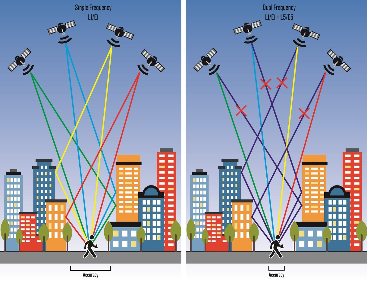
The EU's system is also beginning to broadcast on the L5 frequency (as the E5a band), further increasing current and future accuracy.
This potentially opens up a whole new use scenario for Custom Maps at a much finer degree of detail than is currently enjoyed with the underlying Google Maps interface, necessitating a lat/lon registration method when dealing with maps of far higher resolution than Google Maps can support. Most maps are probably not now able to be georeferenced with an accuracy better than maybe 20 to 25 feet. Things like land surveying would become possible, or maps of closely spaced features, including in remote areas where Google Maps shows no distinguishing features which could be used for positioning points.
Doug Schwartz
On Sat, Mar 26, 2022 at 10:48 AM Carmelo <cpow...@gmail.com> wrote:
Hi,I would also like to be able to enter lat/long coordinates in decimal degrees manually for tie-points.
--
You received this message because you are subscribed to the Google Groups "Custom Maps users" group.
To unsubscribe from this group and stop receiving emails from it, send an email to custom-maps-us...@googlegroups.com.
To view this discussion on the web visit https://groups.google.com/d/msgid/custom-maps-users/bce3ac74-ab63-486d-9119-2e4a83711866n%40googlegroups.com.

Tobias Ekman
Dec 20, 2023, 8:31:00 AM12/20/23
to Jörn Brumme, custom-m...@googlegroups.com
On Sun, 28 Nov 2021 at 18:16, 'Jörn Brumme' via Custom Maps users <custom-m...@googlegroups.com> wrote:
Sometimes it would be nice to take GPS-coordinates created by the phone on a known point if you are out in the field without connection to the internet. Maybe you walk than 1 kilometer or so and than you can take a second GPS shot on another known point and the map is running.
It's already possible with the current version. The best way is to create the map while you're still online using two temporary tie-points. They can be more or less random but Custom Maps will cache the google maps tiles for that area. Then when you're at a known location on the map you adjust the first tie-point to the current GPS location by pressing the icon.
As you walk you adjust or set more tie-points to your GPS-location and the map will recalibrate.
/tekman
Doug Schwartz
Dec 20, 2023, 11:16:08 AM12/20/23
to Tobias Ekman, Jörn Brumme, custom-m...@googlegroups.com
GENIUS! Thank you.
Doug Schwartz
--
You received this message because you are subscribed to the Google Groups "Custom Maps users" group.
To unsubscribe from this group and stop receiving emails from it, send an email to custom-maps-us...@googlegroups.com.
To view this discussion on the web visit https://groups.google.com/d/msgid/custom-maps-users/CAO%2BWSaR8ASn34eRim%2BtDBxZDbqSg8N75dKaU_i959-R%3DP-1HGw%40mail.gmail.com.

Phil Collett
Jan 26, 2024, 12:03:16 PM1/26/24
to Custom Maps users
I understand there is no way to enter Tiepoints with coordinates, but is it possible to edit the Tiepoints, or edit the KMZ to get the tiepoints to an accurate location.
To explain my problem, I need to use an image of GPSed tracks and cave survey and location information.
Tiepoints:
16.945723 101.507054
16.921240 102.530396
If you have time, please look at the Tiepoints to see the problem. Google maps Satellite view shows trees, as it is jungle. Google maps default view shows nothing, as there are no roads, and no tourist style paths.
In the past I have managed to get a georeferenced map of an area not mapped by Google Maps into Custom Maps, but I cannot remember how I did it. Any suggestions please.
Carmelo
Feb 4, 2024, 4:47:21 PM2/4/24
to Custom Maps users
Hi Phil,
The simplest program that I know that can do the job for you is:
MAPC2MAPC
The cost is $25 USD. You can import the image and calibrate (georeference) it there in the software. It runs in two modes depending on what you prefer. Wizard mode has big buttons on the GUI and in advanced mode it has drop-down menus with many more options. If you're in wizard mode, load the image (button - Load an image file and calibrate it) > (button - Calibrate with map coordinates). In the window (view map at xx% shown in title bar at top), choose your points and put in your coordinates, then close the tie-points window (close with "X" in top-right of window). Then click the button "Save the map for a mobile application", then select from list: Garmin Custom Map KMZ.
To work in advanced mode: Load the image: File > Load image for calibration > From Map Coordinates Then export: File > Write Garmin Custom Map (KMZ).
Hopefully with either of these methods, you'll get a kmz file that works for you in the Custom Maps app. However, once when I tried this, I got a folder exported instead of a single kmz file, and if that's the case, follow the instructions below:
For a folder with a .kml file and an image in a subfolder, compress the result into a zip compressed file, with the zip file only containing one folder, (the folder inside is called files or images). The kml file probably will be named: "doc.kml". Change the resulting compressed file extension from .zip to .kmz and it hopefully works in the Custom Maps app.
Otherwise you can use QGIS (free but a big install on your computer and there's some learning of course...)
Or an expensive paid program such as Global Mapper or ArcGIS. The programs will do a lot of GIS functions, however MAPC2MAPC does geo-referencing and conversion of different map formats for mobile app use and that's all it does.
You could probably do it in Google Earth also, however if you try in Google Earth, you would be able to enter your specific tie points, so you'll have the same problem that you had with doing it in the app (Custom Maps).
Another app that will load and display this kind of georeferenced map on Android is called OruxMaps and it has a lot of powerful functions. It will also load georeferenced maps in other formats, such as geospatial PDF or GeoTIFF. Other apps that will load this kmz type of georeferenced map are: Google Earth and QField. If you get into this GIS work more I'd highly recommend ArcGIS on PC and QField on phone. They're both free and quite powerful.
One day if the developer (Marko) has time we'll get more functionality in the Custom Maps app. The ability to define tie-points with coordinates would be a wonderful thing, and as far as I know, that would make it be the only Android app that would have that ability.
Cheers.
Tobias Ekman
Feb 16, 2024, 5:06:43 PM2/16/24
to Phil Collett, Custom Maps users
On Fri, 26 Jan 2024 at 18:03, Phil Collett <philipjo...@gmail.com> wrote:
I understand there is no way to enter Tiepoints with coordinates, but is it possible to edit the Tiepoints, or edit the KMZ to get the tiepoints to an accurate location.
Yes. Create the map with the number of tie-points you have. Export the map to google drive and download it on a computer. Change the extension from ".kmz" to ".zip" and unzip the file in a folder. "doc.kml" is a xml file that contains the calculated LatLonBox for the GroundOverlay and the tie points.
<tie:tiepoint>
<tie:geo>
16.945723,101.507054</tie:geo>
</ tie:tiepoint>
</ tie:tiepoint>
Edit the tie-points and do all the steps backwards. Remember to delete the map before you import the map into Custom Maps. Add and delete a dummy-tie point on the map and when you save the map the correct LatLonBox will be calculated.
/Tobias
Marko Teittinen
Feb 19, 2024, 10:02:11 PM2/19/24
to Tobias Ekman, Phil Collett, Custom Maps users
Thank you Tobias for sending that explanation. That is exactly how the tiepoints can be manually edited for maps created in Custom Maps.
I've been super-busy with my full-time job, so I haven't really even turned on my computer to do any coding in my spare time for a long time. I hope things will eventually settle down and I can get back to my hobby projects. But at this point I don't know at all when that will be.
I still appreciate hearing from all Custom Maps users. Thanks everyone!
Marko Teittinen
--
You received this message because you are subscribed to the Google Groups "Custom Maps users" group.
To unsubscribe from this group and stop receiving emails from it, send an email to custom-maps-us...@googlegroups.com.
To view this discussion on the web visit https://groups.google.com/d/msgid/custom-maps-users/CAO%2BWSaQZaxMjV%3DwRGxECDdnaAN6F2Qf6h6YcgmvWHaN0AvUwsA%40mail.gmail.com.
Reply all
Reply to author
Forward
0 new messages