Re: [cruiser-users] Desktop/App UX
171 views
Skip to first unread message
Message has been deleted

Emux
Nov 24, 2022, 6:47:54 AM11/24/22
to cruise...@googlegroups.com
Thanks a lot for your feedback!
Cruiser platform was used in Kurviger app, so the experience is similar.
> Bookmarks/Favourites - these are easily moved by left-click+drag, meaning that if you re-import a GPX from elsewhere, you'll get dupes. Perhaps a config option to allow drag+move, or CTRL+left-click so it's only done intentionally?
Desktop: this is a nice idea, I will see what can be done.
> I also see no way to remove them before a re-import (the app does this fine, but not on desktop).
Desktop: can multiple select some or all bookmarks in menu "Bookmarks | List" and press the delete "X" button.
Multiple select can be partial with Ctrl + click or continuous with Shift + click.
> Where are my settings located (Bookmarks, last use Route etc)?
Desktop: settings / bookmarks are in Java preferences (registry on Windows / file on macOS / Linux).
> all with the same orange star icon
Many bookmarks improvements are planned (categories, colors / icons, search).
> In the app, if you have a Bookmark as a Via Point and wish to delete that "stop", it's quite easy to delete the actual Bookmark when doing it via the Map.
Desktop: there is context (right click) menu with specific actions on waypoints, bookmarks, etc.
So you can right click on waypoints on map and delete them.
> Searching is not user-friendly for me: Results in BaseCamp are shown as an overlay with their respective icons: Little dots on Cruiser are a bit meaningless.
Do you mean the offline search with the poi files?
Offline search is under development, will be improved in the future.
> If I right-click the map and alter the angle/rotation, how do I reset it to "flat, north up" ?
Desktop: can reset map position with the "Home" key.
> Offline Routing Calculation: 12-sec using Offine GraphHopper vs 2-sec with BaseCamp on a 40mile/1hr route - is this normal?
Is it GraphHopper (offline) routing on both apps?
On Cruiser the GraphHopper speed mode is off, because it does not allow advanced routing / navigation features,
and have memory issues on Android.
> Left-click a Bookmark or POI result to get the info balloon - you can't click anywhere else on the map to close it.
Just click on the info balloon again and it will close.
> The app is great for my style of riding, but even with the zoom settings, not geared towards fat-fingered motorcyclists :( It feels like a lot of presses/menus are required to get to the thing you want to see/change.
There are options for Font + Display size in "Settings | Application" to change the UI scale.
Do they help?
Please continue to provide such detailed feedback and ideas / suggestions,
so we can improve Cruiser more!
--
Emux
Emux
Message has been deleted
Emux
Nov 24, 2022, 7:30:49 AM11/24/22
to cruise...@googlegroups.com
> A "Clear All" would be very useful
I understand and will put it in my list.
> One thing about the GoogleMaps is how stupidly easy it is to get from A to B via a Search button/box
On Android Cruiser there is a search button with fuzzy online search.
It can search locations, coordinates, plus codes, what3words, etc.
And more search providers will be available in the next versions.
In the future I can add search on the bookmarks too.
> GraphHopper (offline) on Cruiser Desktop Java and BaseCamp (PC) using the Freizkarte maps
Freizeitkarte create Mapsforge maps, not contain routing data.
What routing engine do you use in BaseCamp and compare it with GraphHopper (offline) in Cruiser?
Perhaps it is online? If it is GraphHopper (offline), do they use the same graphs?
> the Waypoints list is not pretty in "landscape" mode.
> I would say the same for the top "next stop" box which remains in place while using "follow location" mode in Portrait, but is hidden in Landscape.
Is it possible to provide some screenshots so we can understand better what you describe?
Thanks for the suggestions!
--
Emux
Emux
Message has been deleted
Emux
Nov 24, 2022, 8:15:32 AM11/24/22
to cruise...@googlegroups.com
Thanks for the screenshots.
What Android device is it?
What font + display size app settings?
Indeed, many improvements can be made, especially in landscape mode.
In addition to many new big features coming to the next Cruiser versions,
an improved user interface is also planned, with larger app screens.
What Android device is it?
What font + display size app settings?
Indeed, many improvements can be made, especially in landscape mode.
In addition to many new big features coming to the next Cruiser versions,
an improved user interface is also planned, with larger app screens.
--
Emux
Emux
Message has been deleted

Willy
Nov 24, 2022, 10:24:30 AM11/24/22
to Cruiser Users
Samsung S20. DISPLAY Resolution
1440 x 3200 pixels, 20:9 ratio (~563 ppi density)
1440 x 3200 pixels, 20:9 ratio (~563 ppi density)
Effect by the combination 20:9 ratio and 120% font size.
Op donderdag 24 november 2022 om 14:46:32 UTC+1 schreef MotoRiderUK:
That's good to hear - My phone is a Samsung S20. App/Font-Size: 120%, Map: 100% on all. The Waypoints box width seems to be the issue: Fine on Portrait but just should "fill" the screen in Landscape. I don't think it's a size setting my end.
Message has been deleted
Emux
Nov 24, 2022, 11:12:19 AM11/24/22
to cruise...@googlegroups.com
> Font size only helps to a point,
the box is too narrow at any res.
This is easily resolved, the window can go widescreen or even fill the screen.
And we will need such improvement in many app windows.
I already included it in my list for the next Cruiser versions.
This is easily resolved, the window can go widescreen or even fill the screen.
And we will need such improvement in many app windows.
I already included it in my list for the next Cruiser versions.
--
Emux
Emux
Willy
Nov 25, 2022, 4:36:59 AM11/25/22
to Cruiser Users
Comment concerned only the shown image with 20/9 screen and >120% font size in the portrait mode. Notice the strange truncated "distance spacing list". For this particular nicely presented and therefore useful item the font size should (if possible) always be limited to fit into a maximum 1 line display result . Automatic size limitation possible or not ? No idea, hence the question.
Op donderdag 24 november 2022 om 17:12:19 UTC+1 schreef Emux:

Brinki
Nov 25, 2022, 5:13:36 AM11/25/22
to Cruiser Users
Am 24.11.22 um 11:59 schrieb MotoRiderUK:
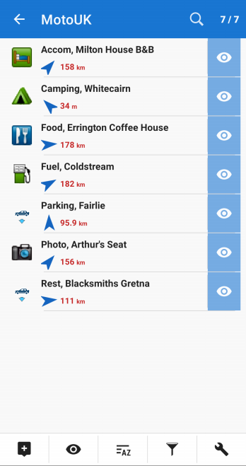
> My BaseCamp-generated GPX has the relevant icons for B&Bs, Fuel, Camping
> etc so is there a way I can have these display on the map without having
> to click them? A text label next to the icon when you zoom in would
> also be useful.
I try to keep things as simple as possible.
For covering our basic needs on camping tours, I have stored this
collection - "https://github.com/GpxFeed/campgrounds" - for offline use
combined with Cruiser on a 1st series i7 netbook with very latest Linux
and our Android smartphones.
One can load pois for campsites, supermarkets, fuel etc. separately for
not to get confused by irrelevant pois and to get the quickest possible
and most complete overview along the planned route. There has never been
any need for special icons or colors.
By the way, as I wrote earlier, the link tag would be a useful addition
to any poi description - besides highlighting and copying the text.
Brinki
Emux
Nov 25, 2022, 5:42:05 AM11/25/22
to cruise...@googlegroups.com
@Brinki thanks for the interesting
collection.
It is very useful, also for tests in development.
It is very useful, also for tests in development.
--
Emux
Emux
Message has been deleted
Brinki
Nov 25, 2022, 7:20:07 AM11/25/22
to Cruiser Users
Am 25.11.22 um 12:20 schrieb MotoRiderUK:
My trick was some Boolean algebra through the backdoor - the jungle is
clearing if you zoom in and focus on your planned route and activity -
most pois and bookmarks will be sorted out automatically - or not.
Brinki
>> has never been any need for special icons or colors
> Really? Here are some Bookmarks along my route:
My trick was some Boolean algebra through the backdoor - the jungle is
clearing if you zoom in and focus on your planned route and activity -
most pois and bookmarks will be sorted out automatically - or not.
Brinki
Message has been deleted
Willy
Nov 25, 2022, 10:05:48 AM11/25/22
to Cruiser Users
Garmin Icons or Dots ? 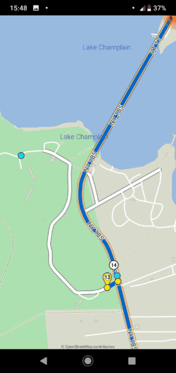
By the attached file.
By the attached file.
Op vrijdag 25 november 2022 om 14:03:21 UTC+1 schreef MotoRiderUK:
I guess it depends upon your method of "filing" and how you plan trips. A splodge of orange stars over the map (especially without a text label at a significant zoom) isn't the best. Turning icons/overlaps on/off during a trip isn't practical, hence the idea of colours (and, potentially, custom icons).For example: OSMAnd lets you import a GPX file and colour accordingly, with an option to toggle the group display on/off. For me, if I was looking at an area to visit, and I'd done my homework, I might want to see very quickly what places I had marked as areas to visit or stay at - with a suitable icon to denote what it was (camera, fuel-pump, tent etc).
Message has been deleted
Willy
Nov 25, 2022, 1:18:23 PM11/25/22
to Cruiser Users
@ MotoRiderUK
Example gpx file pse ?
The problem with gpx is that there is indeed a <sym> definition present in the waypoints but the corresponding Icon is not transfered.
The responsabilty to correctly display the corresponding icons by gpx file transfers so lies entirely to receiving party.
The popular Garmin Icon range contains 266 Garmin Icons.
Providing the 266 Icons into an app is possible, but even this limited range is absolutely not enough to support more specific icons.
What has been neglected in the gpx standard is a method that in addition to the <sym> also transfers the corresponding Icon into a file.
So that the receiving app does not need to set up multiple purpose Icon sets, of which only mostly a few ones will eventually be activated
Could or can it be even done when using gpx files ? Imo it is possible.
But firstly an app developer should be found willing to provide this practically.
As there is no such a standard, the possibilities are still entirely free and open.
Op vrijdag 25 november 2022 om 17:18:24 UTC+1 schreef MotoRiderUK:
Garmin-style icons is what I'm alluding to. The difference between basic dots/orange-star and dedicated icon types/pictures are night+day. A config option (or specified within the GPX file) allowing this would cater for those who wish for the current (orange) star Bookmark, perhaps with an option to change the colour - and also those who may have a desire to differentiate the various stops on their journey.In my screenshot, BaseCamp vs Cruiser Desktop on the same GPX Route.
Message has been deleted
Willy
Nov 25, 2022, 3:05:19 PM11/25/22
to Cruiser Users
Thanks for the file.
Thanks for the file.
This wpt list illustrates was you thus prefer and suggest.
This wpt list illustrates was you thus prefer and suggest.
Op vrijdag 25 november 2022 om 19:30:55 UTC+1 schreef MotoRiderUK:
Yes, I appreciate that the icon names will need to transpose between (competing) applications(!), common-sense would suggest that there should be some kind of standard naming convention for this :)Sample file contains a few places exported directly from BaseCamp.
Message has been deleted
Emux
Nov 26, 2022, 3:06:49 AM11/26/22
to cruise...@googlegroups.com
> Who knows how popular my request
is or how others do it, but it *seems* logical to have the option
of flexibility.
Such a request makes a lot of sense!
And the bookmarks redesign is one of the many big features planned for future versions of Cruiser. :)
Such a request makes a lot of sense!
And the bookmarks redesign is one of the many big features planned for future versions of Cruiser. :)
--
Emux
Emux
Willy
Nov 26, 2022, 3:19:13 AM11/26/22
to Cruiser Users
- Obviously, when zooming out, you have to simplify the Icons to 'dots'.
- "I don't know much about the licence of them". I do not know that either ;-)
- I show some possibilities, how to arrange this in apps I do not determine.
Fact is:
- Garmin standard sym are popular and you come across them quite often.
- However, useful 'Icon' transfers has unfortunately never been regulated.
- So if you want to share these Icons too you end up in unregulated chaos.
See example gpz file.
A "zipped" gpx inclusive images and the icons into folders.
Open idea not used in any app. Anyway you have to start somewhere.
- See in the file how you could transfer corresponding Icons.
* The sender so takes care of the (few) Icons.
* The receiver does not need to "bricolage".
Import this file gpz into the gpx viewer app. (Change to .zip for Locus)
Does show the images, but nothing is provided for Icons to display.
Op vrijdag 25 november 2022 om 22:09:50 UTC+1 schreef MotoRiderUK:
Lekker!Icons like that, presented on the map (and/or in a "near me" list) would work much better than a generic "star" IMHO. Or, as I said before, at least the choice of having Cruiser ingest the GPX icon if available.It's also more useful in Cruiser because, with BaseCamp, you create a blank "List" for an adventure/trip - with 1 or more routes plus waypoints. So it works by Parent/Child Nodes and you copy/paste existing waypoints from "list" into another if you need them in that new route.Cruiser does it better: By having the Bookmarks always visible, but essential they are icons for each type of waypoint rather than a coloured star. In short, I could zoom anywhere on my map and start planning a route with the existing Bookmarks because they are always present - and not have to check other tabs/lists to find where I've hidden that special hotel I bookmarked 3 weeks ago in a different route!I suppose the only real concern here is they *might* be Garmin's own icons. I don't know much about the licence of them - free icons are easily available but if there is an accepted standard or favourite archive, then so much the better.
Who knows how popular my request is or how others do it, but it *seems* logical to have the option of flexibility.
Message has been deleted
Willy
Nov 26, 2022, 4:43:27 AM11/26/22
to Cruiser Users
Yes, this is a problem that has been discussed many times in forums, but without any effective solution. So reviewing this subject with a different view to optimisation is certainly not that unusual imo.
- The sender places the best matching Icon he prefers to be displayed in the "Icons" folder to be sent.
- This way, the receiving app does not have to provide thousands of pre-loaded Icons, there are never enough of them anyway.
- This therefore ensures that a (paying) app is not then faced with Icon licensing trouble. Another important obstacle too, isn't it ?
Op zaterdag 26 november 2022 om 10:32:49 UTC+1 schreef MotoRiderUK:
The display looks good, and yes - some compromise between "detail" and "looks" regarding zoom-level makes sense.A while back, I tried using MapNavigator on my phone, and to get a displayed list of Bookmarks required using a Windoze app called "Digger" which took my BaseCamp-exported GPX of Waypoints and allowed you to inject an image into the resulting .poi file so you could display that group with the specified icon - however, very messy and *not* something a casual user would enjoy doing.Perhaps, at the bare minimum, coloured Bookmark icons (like OSMAnd). Later on, it would certainly be nice to click a new Bookmark and have a small window open with a selection of pretty icons to choose from. In the past, I've used IconArchive to find commercial-free icons for projects - I wonder if, providing the file was a suitable type and size, the dialogue box to select an icon would load whatever images the user had in their own sub-folder?
Emux
Nov 26, 2022, 4:59:53 AM11/26/22
to cruise...@googlegroups.com
Icons can be centered on location
(horizontally + vertically)
or bottom-centered (like the photo.png in your above post).
Is this declared in gpx or are all icons placed the same way?
or bottom-centered (like the photo.png in your above post).
Is this declared in gpx or are all icons placed the same way?
--
Emux
Emux
Willy
Nov 26, 2022, 5:52:05 AM11/26/22
to Cruiser Users
In the simple gpx standard (no extension) No.
Simple <vs > Complicated. Methods ?
Notice options in the Locus manual_forum.
Alignment: "center bottom line" or "center center" alignment.
Icon display size control.
I have never tested nor used this more complicated stuff anyway.
Op zaterdag 26 november 2022 om 10:59:53 UTC+1 schreef Emux:
Willy
Nov 26, 2022, 6:08:18 AM11/26/22
to Cruiser Users
Emux, what I don't like about that Locus method is that the <sym> name changes.
Intended for the Cruiser app, in the (poi)waypoints <type> is still a nice open option.
The <sym> thus remains nicely unchanged and 100% compatible in other apps.
?
Intended for the Cruiser app, in the (poi)waypoints <type> is still a nice open option.
The <sym> thus remains nicely unchanged and 100% compatible in other apps.
?
Op zaterdag 26 november 2022 om 11:52:05 UTC+1 schreef Willy:
Emux
Nov 26, 2022, 6:45:22 AM11/26/22
to cruise...@googlegroups.com
> The <sym> thus remains
nicely unchanged and 100% compatible in other apps.
The <sym> is needed in <trkpt> for the turn
instructions in the GPX navigation tracks.
Isn't the above discussion about the <sym> in <wpt> (POI) where it is free?
Isn't the above discussion about the <sym> in <wpt> (POI) where it is free?
> in the (poi)waypoints <type> is still a nice open option
This can work too.
However, it is also important what do most applications use?
sym, type, ...
However, it is also important what do most applications use?
sym, type, ...
--
Emux
Emux
Willy
Nov 26, 2022, 7:07:55 AM11/26/22
to Cruiser Users
Here we only talk about the <sym> in the free located wpt (poi) so are not intended for navigation.
Sym is also used by other apps. (You can import the sample gpx into gpx viewer...has own icons)
But the alignment is not set by other apps. It can so be done in Cruiser by the type.
Standard (none) is: "center bottom" alignment. The special aligmentso can be specified in the type.
<type>hscc</type> .
(Garmin poi wpt put s<type>user in it. Purpose ? No idea.
I would expect this in src....as the user triggers the placement position not ?
Some apps do even copy the sym tag into the type tag ? Why ? No idea.
Op zaterdag 26 november 2022 om 12:45:22 UTC+1 schreef Emux:
Reply all
Reply to author
Forward
Message has been deleted
0 new messages