Silver Star Wednesday Flight report, etc.: it was an active sky...

mcoppock
Flight report:
Flight plan was to launch in a potential small but auspicious weather window at 3-4pm where cloud cover should have thinned, thermic activity would have restarted, and winds would be shifting from E/SE to SW/W, and high winds would be expected to be above inversion height at 4500’-5K’. Lift was predicted to be 1.5-2 m/s. Plan was to turn right off of launch, get a better understanding of the air mass convective activity, ridge dynamic lift, wind velocity and direction, and then keep my head down below 4500’, to avoid cloud suck and turbulence as much as possible. Plan was an exit to North if conditions dictated bailing sooner rather than later. Launch winds were nil, as is frequently the case on Silver Star, in spite of clear wind activity in clouds just above launch. Very light thermic activity from west, was felt on launch, starting around 3 pm. Launched at 3:20. Northbound along ridge, lift was spotty, but a climb was obtained off the N launch house thermal to ~4200’. Winds were ~12 km/hr from W at this altitude. Conditions were turbulent, likely from wind shear and thermic gusts. Cloudbase was around 4800’, and thermals were typical of high pressure days, and broken by wind. Sink was prevalent along ridge. Max up on FlySkyHy of 3 m/s, down 4.5 m/s. Cumulus cloud activity was vertically limited, but cloud suck present. Mammatus cloud, and strong convergence appeared to west. After a ridge tour, followed flight plan, and bailed N, where clearcuts provided weak, broken thermal support. Landed N of L1100 road on clear cut spur road with unexpected thermic tailwind. As always, views were stupendous: the volcanoes newly covered with fresh snow, and the forest green with new growth, and a misty calm airmass was settled in the valleys below the inversion. The active airmass was well outlined by cloud formation, growth, and dissipation; adding to the pleasure of flying this remarkable site.
Weather observations:
The overall synoptic picture was of a brief upper level ridge forming just east of the Cascades on day of flight, with broken high cloud expected to spill over the top of the ridge. Dry SW flow was predicted. A large upper level trough was approaching from the gulf of Alaska, that would bring a return of showery, colder airmass. Lapse rate was unstable, and humidity was high.
By 12 noon, satellite, and radar returns demonstrated an unpredicted blow up with active precip, moving SW to NE in from the coast, passing over Newberg area, and approaching PDX. On the drive to Silver Star it was raining in Yacolt.
Silver Star massif had orographic lifted cloud forming on west side by 1 pm, and light rain was falling. Cumulus base was around 4400’. No thermic activity or locals flying were noted on hike up.
Main launch was calm on arrival at 2:30 pm. Overcast skies suddenly began clearing, and with the increase in insolation, weak thermic activity from the Coyote Creek drainage began. Impressive mammatus cloud formation was occurring south, west, and North. Winds appeared SW above launch, given cloud motion. Over the Columbia River to the west, ominous dark cloud persisted, but it did not move east significantly over a period of more than one hour.
At 3 pm a commercial turboprop, likely descending on an IFR flight plan in to PDX, ran through scud and cumulus cloud over launch as it descended in to PDX. A frequent reminder that flying at cloudbase on Silver Star entails potential collision risk, given amount of air traffic in the area.
By 4 pm, cloud formation over Silver Star and Tarbell ridge suggested eastward movement of S/SW flow had begun, and it felt good to be on the ground.
Model Correlations:
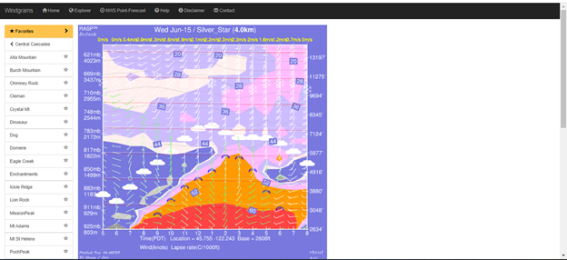
MB shows wind switch from east to West at around 2 pm. The incisure of the predicted lift (black line on the second down graph) shows decrease in upward air velocity around 1-2 pm which was exactly as noted on the walk up. This was likely due to overcast skies inhibiting thermal production. Predicted TOL was 2K meters, which as generous, as is often the case with MB.
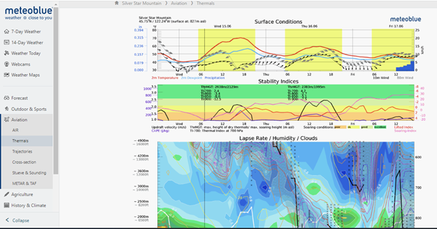
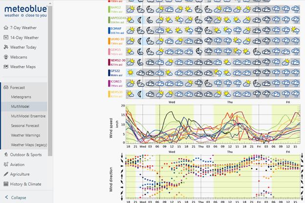
MB multimodel forecast is interesting for some models picking up on the rain, but many not (top graphs) Wind speed was predicted to be low, as it was. (Middle graph). Wind switch to W from E at midday is pretty consistent across models(bottom scattergram).
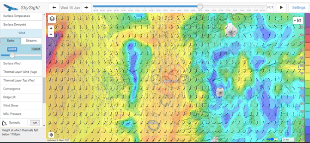
SkySight shows ramped up winds at 6K ft at around launch time. Silver Star (NW of PDX airspace circle) is on the boundary of the strong S flow, which was as predicted. AT 8K winds were predicted to reach 30kts.
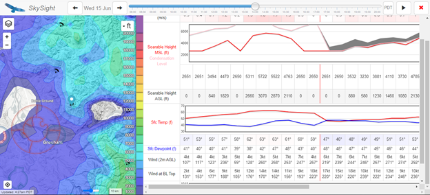
SkySight point forecast for Silver Star showed TOL notch with cloud cover and lack of insolation, then around 5K max in mid afternoon. With shear, and personal skill set limitations, I was unable to climb higher than 4400’ . Variable cloud cover was present over Silver Star all day, reasonably well predicted by most models. Winds were predicted at 12-16 kts at Boundary Layer top, which seemed accurate.
Windgram seemed to be relatively accurate with TOL, winds, and wind direction shift timing. It was relatively successful in describing potential inversion weakening, and cloud cover.
Conclusions:
A narrow flight window was predicted well by most models based on expected insolation, cloud base, wind velocity and direction shifts, precipitation cessation, and temperature. What was not well predicted was the rowdy convergence, and blow up that occurred over PDX, and SW and N of PDX in early afternoon, and then persisted over the Columbia River course N of PDX through late afternoon. A good reminder that predictions are expectations, not reality.
Cheers,
Michael
Sent from Mail for Windows

Stanley Mordensky
--
You received this message because you are subscribed to the Google Groups "Cascade Paragliding Club" group.
To unsubscribe from this group and stop receiving emails from it, send an email to cpcl+uns...@googlegroups.com.
To view this discussion on the web visit https://groups.google.com/d/msgid/cpcl/EB8C7469-8580-477F-8227-CC473E5B34F6%40hxcore.ol.
Michael Coppock
Hi Stan,
Great question re mammatus. I agree that I have also mostly associated them in the past with strong cells, so it was a surprise to see them on Wednesday. Be interesting to hear from an actual meteorologist re their thoughts. Online depicted radar returns showed strong returns in the center of the un-forecast blow up that were persistent for an hour or so, but the convergence/frontal activity over the Columbia did not appear very strong. I did not note the storm's vertical extent on line. The depth and size of the mammatus was less than I've seen below large cells, or severe weather. I can’t explain the multiple areas that showed mammatus, it was strange, and was quite cautionary, hence my close attention to turbulence, wind, and the movement of the system. My understanding is that they themselves do not cause turbulence, and may simply represent descending pockets of cold air/ice crystals, in association with severe weather. So unless an associated dissipating cell produces a gust front, would not expect high winds.
Bottom line: I did not see high vertical storm development, so the pucker factor was only moderate, but I did try to stay at altitudes below 4 K, to stay out of the SW flow, and allow quick descent for incoming weather.
Certainly one should keep well clear of them, and if CB’s forming, not fly. Note CAPE was low yesterday, and OD risk "unlikely" over Silver Star.
Hope to see you on Silver Star this summer!
