Pre-release briefing on Oil & Gas Threat Map: Thursday 6/9 at 2:15 pm
6 views
Skip to first unread message

Nadia Steinzor
Jun 8, 2016, 1:37:16 PM6/8/16
to the-natural-gas-working-group, Fossil FreeNY, SusquehannaCoGasForum, paccwg...@org-lists.salsalabs.com, nygcg, citizensconcerneda...@googlegroups.com
Earthworks, FracTracker and Clean Air Task Force have created what we think is an incredibly useful tool for oil & gas concerned groups, large and small, national and community-based.
We'd like to invite enviros to a briefing about this before we release to the public on 6/14. Feel free to forward to other enviro lists.
Signup here: https://attendee.gotowebinar.com/register/6911208310395294468
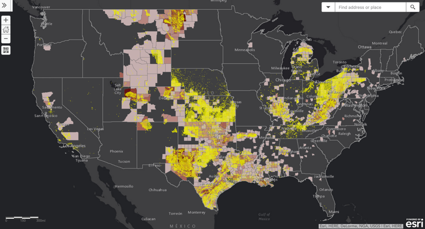
The Oil & Gas Threat Map plots ALL active oil & gas wells in the U.S. in 33 states, and many compressors & processors -- 1.2 million in all. Using that info it:
The Oil & Gas Threat Map plots ALL active oil & gas wells in the U.S. in 33 states, and many compressors & processors -- 1.2 million in all. Using that info it:
- Draws a 1/2 mile threat radius around each facility (an area larger than CA)
- Using Census and other data, calculates the total population inside that area, the total number of schools and medical facilities.
- It displays this data at national, state and county levels
- Allows anyone to enter their street address and find if it falls within the threat radius.
It also includes county-wide cancer/respiratory risk calculated by CATF from EPA's National Emissions Inventory and National Air Toxics Assessment.
Snapshot of the national map (yellow is threat radius, red shaded counties have elevated cancer/respiratory risk):
=== EARTHWORKS: Protecting Communities and the Environment
Nadia Steinzor
Eastern Program Coordinator, Oil & Gas Accountability Project
202-887-1872, ext. 109
nste...@earthworksaction.org
skype: nadia.steinzor-ewa
twitter: @earthworks
Nadia Steinzor
Eastern Program Coordinator, Oil & Gas Accountability Project
202-887-1872, ext. 109
nste...@earthworksaction.org
skype: nadia.steinzor-ewa
twitter: @earthworks
More gas and oil, more pollution. Read about the very real health risks in our reports Reckless Endangerment and Gas Patch Roulette.
The shale boom leaves a lot more behind than gas and oil. Read about the growing problem of polluting waste and its lax management in our report Wasting Away.
Reply all
Reply to author
Forward
0 new messages