[Feedback] New Version
153 views
Skip to first unread message

womisa
Apr 1, 2015, 1:30:01 PM4/1/15
to atla...@googlegroups.com
Hi Emux,
thanks for the new version!
The color of the GeoJson is now very well!
Sort of the Waypoints bug or Fetaurees?
Testcase:
-Insert Depature
-Insert Destination
-Routing OK
-insert Viapoint 1
-Routing OK
-insert Viapont 2
-Routing OK
Now i reorder Via Point 1 with ViaPoint2
- insert the Viapont 1 betwenn ViaPonte2 and Destination
- then the ViaPoint2 is the last and then the destination bevor....
I Think the reorder in the table is a good feature (better than nothing).
I think IMHO a better feature is the graphic inserted new via between any two vias like in broute web ===> http://brouter.de/brouter-web/ ==>This routing is very simple and practical
I am aware that I can re-sort the vias graphically.
Whises:
-Show the Atributes off the GPX File like the Routing ( distance, etc.
Thanks for all
Achim
.

Emux
Apr 1, 2015, 2:01:20 PM4/1/15
to womisa, atla...@googlegroups.com
On 01/04/2015 08:30 μμ, womisa wrote:
The color of the GeoJson is now very well!
:)
Sort of the Waypoints bug or Fetaurees?
I don't understand exactly what you mean - something is not working
right?
The basic idea is to allow the users to reorder / remove the waypoints easily.
A versatile solution is with the new dynamic draggable waypoints list.
After any changes by the user, the route is restructured (depending on waypoints number):
- Departure
- Via-points (if waypoints > 2)
- Destination
The basic idea is to allow the users to reorder / remove the waypoints easily.
A versatile solution is with the new dynamic draggable waypoints list.
After any changes by the user, the route is restructured (depending on waypoints number):
- Departure
- Via-points (if waypoints > 2)
- Destination
I think IMHO a better feature is the graphic inserted new via between any two vias like in broute web ===> http://brouter.de/brouter-web/ ==>This routing is very simple and practical
Yes an interesting implementation.
-Show the Atributes off the GPX File like the Routing ( distance, etc.
Emux
Apr 1, 2015, 2:39:47 PM4/1/15
to womisa, atla...@googlegroups.com
Ok I now understand the issue.
I'll look after it.
I'll look after it.
womisa
Apr 1, 2015, 2:40:00 PM4/1/15
to atla...@googlegroups.com, wms...@googlemail.com
Sort of the Waypoints bug or Fetaurees?
I don't understand exactly what you mean - something is not working right?
I mean..I have two Via1 and Via2 and resort Via1 after Via2 and before Destination then VIA1 (now (Via2 ) is however the Destination OR?
Best regards
Achim
womisa
Apr 1, 2015, 2:47:05 PM4/1/15
to atla...@googlegroups.com, wms...@googlemail.com
Again thank you for the constant feedback!
Sorry is this annoying, but please be honest?
Best regards
Achim
Emux
Apr 1, 2015, 2:50:47 PM4/1/15
to womisa, atla...@googlegroups.com
On 01/04/2015 09:47 μμ, womisa wrote:
Again thank you for the constant feedback!
Sorry is this annoying, but please be honest?
On the contrary, user feedback is valuable for an app or library in
order to get better over time.
womisa
Apr 1, 2015, 2:56:02 PM4/1/15
to atla...@googlegroups.com, wms...@googlemail.com
.......but I know I'm an OLD (Man) grumbler
Best regards
Achim
womisa
Apr 1, 2015, 3:08:59 PM4/1/15
to atla...@googlegroups.com, wms...@googlemail.com
New wishes:
Can you please suport to load a "waypointsxx.gpx" (many?) as layer from mapsforge. I can then use this Waypoints as orientation to generate Vias for routing helper.
(...and demonstration of mapsforge for example....)
What do you think about this?
Best regards
Achim
Can you please suport to load a "waypointsxx.gpx" (many?) as layer from mapsforge. I can then use this Waypoints as orientation to generate Vias for routing helper.
(...and demonstration of mapsforge for example....)
What do you think about this?
Best regards
Achim
Emux
Apr 1, 2015, 3:17:03 PM4/1/15
to atla...@googlegroups.com, wms...@googlemail.com
On 01/04/2015 10:08 μμ, womisa wrote:
Can you please suport to load a "waypointsxx.gpx" (many?) as layer from mapsforge. I can then use this Waypoints as orientation to generate Vias for routing helper.
(...and demonstration of mapsforge for example....)
Can you be more specific?
There is currently support for all GPX types (waypoints, routes, tracks).
For waypoints an analysis takes place and the bubbles fill with e.g. title, description, elevation.
For routes / tracks besides the line overlay,
if the route / track points have also more information, then there are also bubble markers for them.
womisa
Apr 1, 2015, 3:36:06 PM4/1/15
to atla...@googlegroups.com, wms...@googlemail.com
I think i must test to load and play with a a Waypoint GPX File into Atlas....sorry for the confuse request.....
Best regards
Achim
Best regards
Achim
womisa
Apr 1, 2015, 4:02:03 PM4/1/15
to atla...@googlegroups.com, wms...@googlemail.com
..i think i mean the possibility to save a routing file(gpx) only with the routing points (Waypoints?) Departure,Via1 to Via_xx, Destination (without the relevant routing-information ponts) and then the possibility to load this file to modify the route....and save again....load again....modify route ...save again... and so on...
Best regards
Achim
Best regards
Achim
Emux
Apr 1, 2015, 4:07:57 PM4/1/15
to womisa, atla...@googlegroups.com
On 01/04/2015 11:02 μμ, womisa wrote:
..i think i mean the possibility to save a routing file(gpx) only with the routing points (Waypoints?) Departure,Via1 to Via_xx, Destination (without the relevant routing-information ponts) and then the possibility to load this file to modify the route....and save again....load again....modify route ...save again... and so on...
Ok I see what you mean.
Yes that's a useful feature, it's worth checking it.
Yes that's a useful feature, it's worth checking it.
Emux
Apr 1, 2015, 5:24:36 PM4/1/15
to womisa, atla...@googlegroups.com
On 01/04/2015 09:40 μμ, womisa wrote:
I mean..I have two Via1 and Via2 and resort Via1 after Via2 and before Destination then VIA1 (now (Via2 ) is however the Destination OR?
I published new version of Atlas with a fix for the above issue.
Thanks again for the report.
Thanks again for the report.
womisa
Apr 2, 2015, 3:48:01 AM4/2/15
to atla...@googlegroups.com, wms...@googlemail.com
Hi Emux,
thanks for the new version. This works as intended.
Best regards
Achim
thanks for the new version. This works as intended.
Best regards
Achim
womisa
Apr 2, 2015, 4:14:35 AM4/2/15
to atla...@googlegroups.com, wms...@googlemail.com
Hi Emux,
I would like to make a suggestion, which is
If you save it so you can download and use to reroute it again.
The standard tools should be able to process this format.
Best regards
Achim
I would like to make a suggestion, which is
"http://www.topografix.com/GPX/1/1" compliant.If you save it so you can download and use to reroute it again.
The standard tools should be able to process this format.
Best regards
Achim
<?xml version="1.0" encoding="UTF-8" standalone="no" ?>
<gpx xmlns="http://www.topografix.com/GPX/1/1" xmlns:xsi="http://www.w3.org/2001/XMLSchema-instance"
     creator="Graphhopper" version="1.1" xmlns:gh="https://graphhopper.com/public/schema/gpx/1.1">
    <metadata>
        <copyright author="OpenStreetMap contributors"/>
        <link href="http://graphhopper.com">
            <text>GraphHopper GPX</text>
        </link>
        <time>1970-01-01T00:00:00+00:00</time>
    </metadata>

    <trk>
        <trkseg>
            <trkpt lat="" lon=""></trkpt>  //Depature
            ......
            ......
            <trkpt lat="" lon=""></trkpt>
        </trkseg>
        <trkseg>
            <trkpt lat="" lon=""></trkpt> // Via-point 1
            .........
            .........
            <trkpt lat="" lon=""></trkpt>
        </trkseg>
        ............. etc.............
        <trkseg>
            <trkpt lat="" lon=""></trkpt> // Via-point x
            ........
            ........
            <trkpt lat="" lon=""></trkpt>
        </trkseg>

        ............. etc.............

        <trkseg>
            <trkpt lat="" lon=""></trkpt> // Via-point n
            ......
            .......
            <trkpt lat="" lon=""></trkpt>   // Destination
        </trkseg>


    </trk>


</gpx>
Emux
Apr 2, 2015, 4:19:30 AM4/2/15
to womisa, atla...@googlegroups.com
Shouldn't it be better with waypoints ?
Tools usually connect track points and paint a line from them.
Tools usually connect track points and paint a line from them.
Emux
Apr 2, 2015, 4:26:08 AM4/2/15
to womisa, atla...@googlegroups.com
I have proposed to Peter to review GraphHopper GPX export feature.
https://github.com/graphhopper/graphhopper/issues/310
When I find some time I can create a pull request at GraphHopper with the proper changes.
Additionally I could implement a new GPX export with more options as needed.
https://github.com/graphhopper/graphhopper/issues/310
When I find some time I can create a pull request at GraphHopper with the proper changes.
Additionally I could implement a new GPX export with more options as needed.
womisa
Apr 2, 2015, 4:45:09 AM4/2/15
to atla...@googlegroups.com, wms...@googlemail.com
Am Donnerstag, 2. April 2015 10:19:30 UTC+2 schrieb Emux:
Shouldn't it be better with waypoints ?
Tools usually connect track points and paint a line from them.
That's how it should be!. The problem with Graphhopper is that both a route and a track in a file is.
If you have exported only one segmented track at my suggestion it's a normal track like many tools (eg Oruxmaps).
But your tool (Atlas) can extract the Routepoints and show/highlight it for modification.
-first trackpoint ==>Depature
-each first <trp> in a segment is a ViaPoint ( except the first one ==> Depature)
-last trackpoint ==> Destination
Best regards
Achim
womisa
Apr 2, 2015, 7:17:08 AM4/2/15
to atla...@googlegroups.com, wms...@googlemail.com
Shouldn't it be better with waypoints ?
waypoints with the instructions from Graphhoper is a additional feature to the segmented track
Tools usually connect track points and paint a line from them.
Best regards
Achim
Achim
Emux
Apr 2, 2015, 8:26:41 AM4/2/15
to womisa, atla...@googlegroups.com
I was meaning that saving just the
route points (start, via, end) in a file for later use, we need
only their coordinates.
So shouldn't we use in the gpx format the "waypoints" for that?
After all we're saving strictly points.
So shouldn't we use in the gpx format the "waypoints" for that?
After all we're saving strictly points.
Emux
Apr 2, 2015, 8:41:27 AM4/2/15
to atla...@googlegroups.com, wms...@googlemail.com
On 01/04/2015 08:30 μμ, womisa wrote:
I think IMHO a better feature is the graphic inserted new via between any two vias like in broute web ===> http://brouter.de/brouter-web/ ==>This routing is very simple and practical
Could you explain more the benefits of that UI?
i.e. for inserting intermediate waypoints we can do with right click in Atlas and long press in Cruiser.
The removal of a waypoint can be accomplished via dialog in both apps.
(Because with the tap we show bubbles with info)
i.e. for inserting intermediate waypoints we can do with right click in Atlas and long press in Cruiser.
The removal of a waypoint can be accomplished via dialog in both apps.
(Because with the tap we show bubbles with info)
Emux
Apr 2, 2015, 8:57:14 AM4/2/15
to womisa, atla...@googlegroups.com
Can you check also the UI of GraphHopper (right click)
and OSRM (similar to
BRouter) ?
womisa
Apr 2, 2015, 10:46:58 AM4/2/15
to atla...@googlegroups.com, wms...@googlemail.com
Am Donnerstag, 2. April 2015 14:57:14 UTC+2 schrieb Emux:
sure, I know these functions .
..However the possibility , it is always inserted VIAs at the last Via and the Destinatin. I now the resort in the dialog....
Could you explain more the benefits of that UI?
I can click,click,click.... for routing
-first klick ==> Atlas (Depature with right click an Depature select)
-second click ==> Via Point 1
-third click ==> Viapoint 2
..and so on
- x. Klick ===> Viapoint x
-last click ==> Destination
ESC or 'q' end routemode
I can now insert and position (VIAs) at any position between two Viapoints via drag on the routeline (white dot) new Viapoints
With "d" i can continue the routing at the end (Dstination ==> last Via) click, cklick...each click inserts a neu Via ESC or 'q' ends routing and the last point are the Destination.
All without dialog....
In addition, I think you should be able to give the vias name for better orientation and re-sorting (Place ofbeer, castle Womisa, bicycle nod_x,GeoCache xx...)
Best regards
Achim
Emux
Apr 2, 2015, 12:37:22 PM4/2/15
to womisa, atla...@googlegroups.com
On 02/04/2015 05:46 μμ, womisa wrote:
..However the possibility , it is always inserted VIAs at the last Via and the Destinatin.
Ok I understand the usefulness of that.
In addition, I think you should be able to give the vias name for better orientation and re-sorting (Place ofbeer, castle Womisa, bicycle nod_x,GeoCache xx...)
Also a nice idea!
For all these there is thought to be done for the UI.
For all these there is thought to be done for the UI.
womisa
Apr 28, 2015, 4:29:45 AM4/28/15
to atla...@googlegroups.com
Hi Emux,
thanks for your new version.
Wishes:
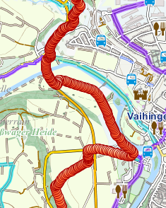
When I load a track with a lot Trasckpoints generated by the GPS in Atlas Atlas is then slowly and somewhat confusing. You can only nn trackpoints per Km take depending on the zoom level?
It would also be nice if the "Screenshot" would be in addition in the clipboard
Kindly regards
Achim
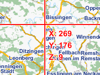
Ps: FYI: The Rendering on the tile boundaries are partially incorrect ( for example . Asperg and Schwieberdingen on the pcture)
thanks for your new version.
Wishes:
When I load a track with a lot Trasckpoints generated by the GPS in Atlas Atlas is then slowly and somewhat confusing. You can only nn trackpoints per Km take depending on the zoom level?
It would also be nice if the "Screenshot" would be in addition in the clipboard
Kindly regards
Achim
Ps: FYI: The Rendering on the tile boundaries are partially incorrect ( for example . Asperg and Schwieberdingen on the pcture)
Emux
Apr 28, 2015, 4:45:43 AM4/28/15
to womisa, atla...@googlegroups.com
Thanks for the feedback.
On 28/04/2015 11:29 πμ, womisa wrote:
When I load a track with a lot Trasckpoints generated by the GPS in Atlas Atlas is then slowly and somewhat confusing. You can only nn trackpoints per Km take depending on the zoom level?
I place track points if they have information for the user (like
name) to click them.
For tracks it would be better to show simply the line?
For tracks it would be better to show simply the line?
It would also be nice if the "Screenshot" would be in addition in the clipboard
Agreed, will be added in next version.
Ps: FYI: The Rendering on the tile boundaries are partially incorrect ( for example . Asperg and Schwieberdingen on the pcture)
You mean the tile grid hides the below map elements (normal
behavior) or we have half labels on the map itself?
womisa
Apr 28, 2015, 5:22:26 AM4/28/15
to atla...@googlegroups.com, wms...@googlemail.com
Thanks for the responce!
When I load a track with a lot Trasckpoints generated by the GPS in Atlas Atlas is then slowly and somewhat confusing. You can only nn trackpoints per Km take depending on the zoom level?
I place track points if they have information for the user (like name) to click them.
For tracks it would be better to show simply the line?
....i think yes.
In the future, you should be able to select a track point which you then can see. Or can set a waypoint I have in mind that you can use this track for a new rerouting (modify).
It would also be nice if the "Screenshot" would be in addition in the clipboard
Agreed, will be added in next version.
.....thanks again.
Ps: FYI: The Rendering on the tile boundaries are partially incorrect ( for example . Asperg and Schwieberdingen on the pcture)
You mean the tile grid hides the below map elements (normal behavior)
no.
or we have half labels on the map itself?
yes. Show the picture (without the Grid)
Asberg ==> erg
Schwieberdingen==> ingen
Korntal-Münchingen ==>chingen
...and many,many more
Kindly regads
Achim
Ps: The Mobac Author has made -(my long-awaited MFG Tileserver)- a simple Tileserver for Mapsforge with the same effect hier
or the develar MapsforgeServer with this effects hier
Emux
Apr 28, 2015, 5:37:07 AM4/28/15
to womisa, atla...@googlegroups.com
On 28/04/2015 12:22 μμ, womisa wrote:
or we have half labels on the map itself?
yes. Show the picture (without the Grid)
Asberg ==> erg
Schwieberdingen==> ingen
Korntal-Münchingen ==>chingen
Sorry that I cannot confirm that (screenshot).
BTW are you playing with LabelLayer enabled or not?
If you reload the map (from Tools) in order to clear the cache, what do you see?
BTW are you playing with LabelLayer enabled or not?
If you reload the map (from Tools) in order to clear the cache, what do you see?
Mapsforge uses an internal cache mechanism prior drawing in order to
handle the labels / symbols at tile borders.
Apparently simply using the rendering engine for getting a z/x/y bitmap would skip that.
Apparently simply using the rendering engine for getting a z/x/y bitmap would skip that.
womisa
Apr 28, 2015, 6:11:12 AM4/28/15
to atla...@googlegroups.com, wms...@googlemail.com
Thanks for the clarification. I have now clear the cache and it is ok!
If you reload the map (from Tools) in order to clear the cache, what do you see?
Thanks for the clarification. I have now clear the cache and it is ok!
Mapsforge uses an internal cache mechanism prior drawing in order to handle the labels / symbols at tile borders.
Apparently simply using the rendering engine for getting a z/x/y bitmap would skip that.
Emux
Jun 5, 2015, 1:26:43 PM6/5/15
to womisa, atla...@googlegroups.com
New versions include (among other
features):
- GPX tracks rendering as simple lines
- Screenshot can be copied to clipboard
- GPX tracks rendering as simple lines
- Screenshot can be copied to clipboard
womisa
Jun 7, 2015, 6:20:30 AM6/7/15
to atla...@googlegroups.com, wms...@googlemail.com
Hi Emux,
Thanks for the new features. This works very well for me.
Thanks for the new features. This works very well for me.
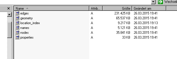
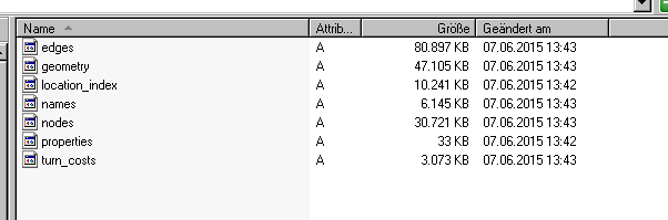
- Question:The new Graph Hopper graph is much smaller (Baden-Wuerttemberg e.g. edges old = 231.425KB edges new 80.897.
- Is that right ?
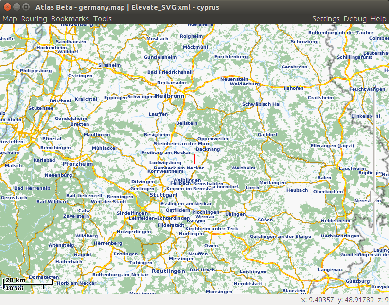
- Each time you restart the "Tile Grid" is displayed. Is that intentional?
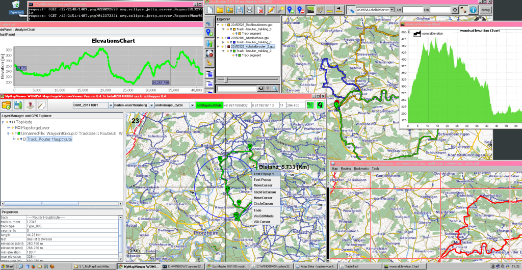
- For the distance measurement I had an expansion proposal: Draw an additional distance circle. See my picture. I've got several cursor modes
- The most missed features are a Elevationdiagrammund compress the possibility a logged GPS track. Both functions can you get from Graphhopper ready (Elevation, Douglas Peuker) and the OSM Attribute lige BRouterweb (eg. Trackgrade)
As a suggestion:
- MOBAC Mapsforge Webserver. http://sourceforge.net/p/mobac/code/HEAD/tree/trunk/tools/MapsforgeSrv/ ..ok Problem Labelrendering but tbetter than nothing
- I have the MobacServer in Gpsmaster purely chopped in conjunction with Graph Hopper and BRouter. GpsMaster has a super Gpx management (tracks hide/show, color change, etc ..)
Thanks again for Atlas!
Kindly regards
Achim
Emux
Jun 7, 2015, 7:04:06 AM6/7/15
to womisa, atla...@googlegroups.com
On 07/06/2015 01:20 μμ, womisa wrote:
Question:The new Graph Hopper graph is much smaller (Baden-Wuerttemberg e.g. edges old = 231.425KB edges new 80.897.
Are you sure? I just created the graph with pbf from Geofabrik and
it's 174MB.
The default graph creation settings (as seen in graph.properties file) are car,foot,bike with turn costs.
Have you modified the graph.properties file?
The default graph creation settings (as seen in graph.properties file) are car,foot,bike with turn costs.
Have you modified the graph.properties file?
Each time you restart the "Tile Grid" is displayed. Is that intentional?
You mean the Debug - Tile grid?
You can set it on/off and it should hold the preference on restart, at least that's how I see it.
Thanks for the feedback and the suggestions.
You can set it on/off and it should hold the preference on restart, at least that's how I see it.
Thanks for the feedback and the suggestions.
womisa
Jun 7, 2015, 7:59:57 AM6/7/15
to atla...@googlegroups.com, wms...@googlemail.com
Am Sonntag, 7. Juni 2015 13:04:06 UTC+2 schrieb Emux:
On 07/06/2015 01:20 μμ, womisa wrote:
Question:The new Graph Hopper graph is much smaller (Baden-Wuerttemberg e.g. edges old = 231.425KB edges new 80.897.
Are you sure? I just created the graph with pbf from Geofabrik and it's 174MB.
????..I have downloaded Baden-Wuerttemberg from here ==> http://download.geofabrik.de/europe/germany.html
20150606_baden-wuerttemberg-latest.osm.pbf with 342.982KB
the old
20150304_baden-wuerttemberg-latest.osm.pbf with 331.737 KB
20150606_baden-wuerttemberg-latest.osm.pbf with 342.982KB
the old
20150304_baden-wuerttemberg-latest.osm.pbf with 331.737 KB
The default graph creation settings (as seen in graph.properties file) are car,foot,bike with turn costs.
Have you modified the graph.properties file?
...no >> graph.flagEncoders=car|turnCosts=true,foot,bike
Output LogWindow:
GraphHopper Initialization ERROR: cannot read version!? null
GraphHopper Initialization WARNING: cannot get version!?
see the Snapshots from graph Dir Old vs New.....
But the routing works.
Output LogWindow:
GraphHopper Initialization ERROR: cannot read version!? null
GraphHopper Initialization WARNING: cannot get version!?
see the Snapshots from graph Dir Old vs New.....
But the routing works.
Each time you restart the "Tile Grid" is displayed. Is that intentional?
>You mean the Debug - Tile grid?
>You can set it on/off and it should hold the preference on restart, at least that's how I see it.
Sorry that was my fault. I have Atlas in the virtual box and by restart from the "clear VB" i have this effect
Kindly regards
Achim
Kindly regards
Achim
Emux
Jun 7, 2015, 8:08:21 AM6/7/15
to womisa, atla...@googlegroups.com
Seeing the date of the old graph, was
this created by me?
Those days I included also elevation data, which could increase the graph size.
Now the default settings are without elevation.
But it's supported by Cruiser / Atlas
and can be enabled in the graph.properties file.
Those days I included also elevation data, which could increase the graph size.
Now the default settings are without elevation.
But it's supported by Cruiser / Atlas
and can be enabled in the graph.properties file.
Reply all
Reply to author
Forward
0 new messages