Leaflet & OSM mapping experiment on aprs.fi
751 views
Skip to first unread message

Heikki Hannikainen
Jan 11, 2023, 6:29:53 PM1/11/23
to apr...@googlegroups.com
Hi,
https://aprs.fi is experimenting with Leaflet & OSM mapping starting
tonight. A small percentage of visitors will get Leaflet & OSM, and I'll
keep an eye on whether the tile server explodes or not. If it doesn't,
I'll increase the percentage tomorrow. There's no way to opt out from the
experiment at this time, other than changing your IP address.
It’ll be drawing the maps a bit slowly in the beginning and some features
are missing. PHG circles are not being drawn, for one. There's no
satellite/aerial views, and no Street View. I can implement PHG a bit
later, Street View cannot be done, some satellite imagery might be
possible but it won't be as good as with Google Maps.
I’ll have to do this to avoid a recurrence of a Noticeably Large bill I
got for Google Maps usage in December (think "one new nice HF rig every
month" large, or "one VERY nice HF rig every two months"). Google has had
a very large and generous free quota for use of Google Maps on aprs.fi,
but it's been a bit unstable and sometimes a bit too small after all, and
I need a backup plan in case it goes away.
The plan consists of three main bits:
* Leaflet (https://leafletjs.com/) is the JavaScript library responsible
for implementing the slippy map. It runs in your web browser, loads map
image tiles from a tile server, lets you pan & zoom around, and provides
aprs.fi with the necessary bits to draw station symbols and lines and
other overlays on top of the map.
* OpenStreetMaps (OSM) is the map data set I download (some 73 GB of it
currently) and push in a database running on my Tile Server.
* A Tile Server, which I now run, which produces square PNG images from
the OSM vector map data, which your browser downloads and displays. I
suspect it'll be a noticeable pain to keep it running smoothly.
I have had Leaflet mostly implemented for some time, it just has not been
enabled before now. There's probably a few bugs here and there which need
to be ironed out - please let me know when you find one. Just reply to
this post. Thanks!
I have a fairly nice 16-CPU 128 GB RAM dual-SSD-drive server running the
map tile server, but it's still a bit laggy until it has cached enough
tiles.
To make it run fast enough, buildings, amenities, lamp posts and similar
less important items are not loaded in the map database. Country borders
are accidentally missing, I'll add them in the next rebuild after figuring
out what else is missing.
- Hessu

Don Rolph
Jan 11, 2023, 7:07:04 PM1/11/23
to apr...@googlegroups.com
Good luck.
Sent from my iPad
> On Jan 11, 2023, at 6:29 PM, Heikki Hannikainen <he...@hes.iki.fi> wrote:
>
>
> --
> You received this message because you are subscribed to the Google Groups "aprs.fi" group.
> To unsubscribe from this group and stop receiving emails from it, send an email to aprsfi+un...@googlegroups.com.
> To view this discussion on the web visit https://groups.google.com/d/msgid/aprsfi/alpine.DEB.2.21.2301120052350.23380%40jazz2.he.fi.
Sent from my iPad
> On Jan 11, 2023, at 6:29 PM, Heikki Hannikainen <he...@hes.iki.fi> wrote:
>
>
> You received this message because you are subscribed to the Google Groups "aprs.fi" group.
> To unsubscribe from this group and stop receiving emails from it, send an email to aprsfi+un...@googlegroups.com.
> To view this discussion on the web visit https://groups.google.com/d/msgid/aprsfi/alpine.DEB.2.21.2301120052350.23380%40jazz2.he.fi.

Arnie Shore
Jan 11, 2023, 8:03:03 PM1/11/23
to apr...@googlegroups.com
A big high-five on this, from this Open-Source enthusiast. A super initiative.
AS

Nosey Nick VA3NNW
Jan 12, 2023, 1:21:42 AM1/12/23
to aprs.fi
Ditto! I've used Leaflet for some of my own projects, including some
APRS-related ones, and it's lovely! I also use OSM data for all my own
personal online and offline mapping needs (who needs google maps?), and
my company runs one of the UK tileservers.
73 de Nick VA3NNW
73 de Nick VA3NNW
Heikki Hannikainen
Jan 12, 2023, 2:49:25 AM1/12/23
to aprs.fi
On Wed, 11 Jan 2023, Nosey Nick VA3NNW wrote:
> Ditto! I've used Leaflet for some of my own projects, including some
> APRS-related ones, and it's lovely! I also use OSM data for all my own
> personal online and offline mapping needs (who needs google maps?), and
> my company runs one of the UK tileservers.
The OSM data is quite good these days in many areas, but lacks in others
> Ditto! I've used Leaflet for some of my own projects, including some
> APRS-related ones, and it's lovely! I also use OSM data for all my own
> personal online and offline mapping needs (who needs google maps?), and
> my company runs one of the UK tileservers.
(rural areas may be hit-and-miss).
I gradually shifted 100% of http://aprs.fi visitors on the Leaflet map &
OSM tile server this morning. Good news: it's not immediately breaking up!
In addition to country borders I also forgot to load country/city names in
the database 🤦♂️
How does the OSM tile server hosting work out, do you actually maintain
the service or just host the physical server for the OSM operations group
who maintains it?
I sent an email to the OSMF Operations Working Group asking for permission
to use their tile service on aprs.fi. It'd sure be less hassle if they'd
allow it.
- Hessu

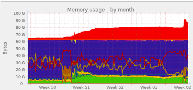
Lynn W Deffenbaugh (Mr)
Jan 12, 2023, 11:10:51 AM1/12/23
to apr...@googlegroups.com, Heikki Hannikainen
Here's hoping the OSMF allows you
unrestricted access to their tile servers. That would be MUCH
easier than configuring, running, and maintaining your own tile
server. I tried to find the map tile that they return if they
think you've abused their servers, but came up empty.
I'm doing a full re-render of my cached
tiles on my own tile server having updated to the latest OSM style
sheet and was reminded of one issue that you need to be aware
of. When rendering lower level zooms, renderd will grown in
physical and virtual memory use and won't shrink back down until
you restart the service. So if your tile server seems like it is
getting sluggish, check the swap usage and you'll probably find
renderd swapping while rendering. "systemctl restart renderd"
does wonders! The following graph shows what happens if when I
forgot about this "feature":
Lynn (D) - KJ4ERJ - Author of APRSISCE
for Windows Mobile and Win32
PS. For those not familiar with OSM's
Tile Usage Policy, you can read about it here:
The key statement is:
OpenStreetMap data is free for everyone to use. Our tile servers are not.
Heikki Hannikainen
Jan 12, 2023, 5:54:35 PM1/12/23
to apr...@googlegroups.com
On Thu, 12 Jan 2023, Lynn W Deffenbaugh (Mr) wrote:
> Here's hoping the OSMF allows you unrestricted access to their tile
> servers. That would be MUCH easier than configuring, running, and
> maintaining your own tile server. I tried to find the map tile that they
> return if they think you've abused their servers, but came up empty.
Yep. It's been possible to select OSM tiles on aprs.fi previously using
> Here's hoping the OSMF allows you unrestricted access to their tile
> servers. That would be MUCH easier than configuring, running, and
> maintaining your own tile server. I tried to find the map tile that they
> return if they think you've abused their servers, but came up empty.
the Google Maps JS API tooling, but very few visitors actually used it.
Now my tile server is handling some 40-50 requests per second which would
actually cost something on the CDN (which is currently sponsored to OSMF
by fastly if I read their 2023 budget right).
> I'm doing a full re-render of my cached tiles on my own tile server having
> updated to the latest OSM style sheet and was reminded of one issue that you
> need to be aware of. When rendering lower level zooms, renderd will grown
> in physical and virtual memory use and won't shrink back down until you
> restart the service.
https://github.com/openstreetmap/mod_tile/issues/181#issuecomment-813253225
I'll have to reload the DB with a new set of filters to get place names
and administrative boundaries (country borders etc) in place, after
figuring out what else we're missing. If someone can spot something that
really should be in the map tiles, but isn't, please speak out now. :)
It'll be interesting to see if the server is capable of reloading the data
set in a new database in parallel while serving tiles from the previous
database. I have it running in a docker container so recreating it with
slightly different settings is easy, it just takes 4.5 hours with fairly
high parallelism on the 16-CPU box, and with the service running I'll
surely have to run it slower.
- Hessu
Lynn W Deffenbaugh (Mr)
Jan 12, 2023, 6:28:28 PM1/12/23
to apr...@googlegroups.com, Heikki Hannikainen
On 1/12/2023 5:54 PM, Heikki Hannikainen wrote:
> On Thu, 12 Jan 2023, Lynn W Deffenbaugh (Mr) wrote:
>
>> I'm doing a full re-render of my cached tiles on my own tile server
>> having updated to the latest OSM style sheet and was reminded of one
>> issue that you need to be aware of. When rendering lower level
>> zooms, renderd will grown in physical and virtual memory use and
>> won't shrink back down until you restart the service.
>
> Noticed! Disabling JIT in PG seemed to help with memory use, too.
>
> https://github.com/openstreetmap/mod_tile/issues/181#issuecomment-813253225
>
Crazy! I just threw the jit switch on my tile server while upgrading
> On Thu, 12 Jan 2023, Lynn W Deffenbaugh (Mr) wrote:
>
>> I'm doing a full re-render of my cached tiles on my own tile server
>> having updated to the latest OSM style sheet and was reminded of one
>> issue that you need to be aware of. When rendering lower level
>> zooms, renderd will grown in physical and virtual memory use and
>> won't shrink back down until you restart the service.
>
> Noticed! Disabling JIT in PG seemed to help with memory use, too.
>
> https://github.com/openstreetmap/mod_tile/issues/181#issuecomment-813253225
>
to the latest OSM stylesheet. It's listed as one of the
openstreetmap-carto installation steps, but interestingly not copied
through to the Switch2OSM guides.
https://github.com/gravitystorm/openstreetmap-carto/blob/master/INSTALL.md#disable-jit

Randy Nelson
Jan 13, 2023, 2:59:27 AM1/13/23
to aprs.fi
Nosey Nick VA3NNW
Jan 13, 2023, 3:00:00 AM1/13/23
to aprs.fi
Heikki Hannikainen wrote:
I gradually shifted 100% of http://aprs.fi visitors on the Leaflet map &
OSM tile server this morning. Good news: it's not immediately breaking up!
How does the OSM tile server hosting work out, do you actually maintain
the service or just host the physical server for the OSM operations group
who maintains it?
I sent an email to the OSMF Operations Working Group asking for permission
to use their tile service on aprs.fi. It'd sure be less hassle if they'd
allow it.
The OSM data is quite good these days in many areas, but lacks in others
(rural areas may be hit-and-miss).
(rural areas may be hit-and-miss).
... but fixable if there's areas you know / can edit yourself! :-)
OSM tile server this morning. Good news: it's not immediately breaking up!
Well I'm liking the new look!
the service or just host the physical server for the OSM operations group
who maintains it?
I'll confess I don't know much about it, it was set up by someone else at my company, but I think it was just that we gave them a VM of X CPU / Y memory / Z disk, installed the base distro they asked for, dropped an SSH key onto it and handed it over to the OSM team to install / maintain it from then on.
to use their tile service on aprs.fi. It'd sure be less hassle if they'd
allow it.
Depending on how you pay for bandwidth, this can work out quite well, I think that's how my company ended up hosting one. When you're buying enough bandwidth, "local" bandwidth is mega-cheap (almost free) but international / transit costs a lot more. We could have run our own exclusive tile server, for only "our" users, but globally... or if we donate a server to the pool, it serves a lot more "local" users (almost free) because their GeoIP sends users to their "closest" tile server(s)... but our international users get to use OSM pool servers much more "local" to them. Cheaper on our bandwidth bill, faster AND more resilient for our international users, win-win-win!
Nick VA3NNW
Heikki Hannikainen
Jan 13, 2023, 4:53:56 AM1/13/23
to aprs.fi
On Thu, 12 Jan 2023, Randy Nelson wrote:
> What's the secret to get aprs.fi new map to work in Chrome? I've
> allowed JS for aprs.fi but still no stations appear. Also get a "site
> is having problems" error when I try and do a track callsign search.
> FireFox is working OK but it's not my daily browser.
Do you have some unusual plugins or settings in Chrome, or is it a bog
> What's the secret to get aprs.fi new map to work in Chrome? I've
> allowed JS for aprs.fi but still no stations appear. Also get a "site
> is having problems" error when I try and do a track callsign search.
> FireFox is working OK but it's not my daily browser.
standard basic Chrome install?
I do all of my normal development and testing work on Chrome, and it does
seem work for me. Not a lot of complaints like this are coming in, so I
suppose it does work for most people.
- Hessu

Christian H
Jan 13, 2023, 5:16:07 AM1/13/23
to apr...@googlegroups.com
Very interesting Heikki.
And a bit funny.As a active contributor to OSM, I would also like to point out as you say.
That area's lacking data in OSM, are a very fixable problem :).
What comes to Finland at least, we have exceptionally good, open-data too, for most of the needs.
Ranging from forests to landuse.. etc etc
The biggest problem many times, for fixing large areas at once, by doing imports.
Is actually trying to coordinate these processes with the OSM community.
When you go to a main OSM channel and propose a mass import.
You get told to go to your country specific osm channel.
And well, when you get there, it might be quite passive.
Ahh but yeah.. to the point...
I like it, that there is a transition taking place, over to Leaflet instead.
Thumbs up. // OH6FOR
--
You received this message because you are subscribed to the Google Groups "aprs.fi" group.
To unsubscribe from this group and stop receiving emails from it, send an email to aprsfi+un...@googlegroups.com.
To view this discussion on the web visit https://groups.google.com/d/msgid/aprsfi/alpine.DEB.2.21.2301131151220.23909%40jazz2.he.fi.
--
73s de OH6FOR Christian Hansson

Todd Dugdale
Jan 13, 2023, 7:07:15 AM1/13/23
to aprs.fi
I must be one of the accounts being experimented on. My experience: when I go to my local map, I get an OSM map and "Loading" overlayed on it without any stations shown. It's been ten minutes, and no stations have appeared. When I try to see my gateway's "gated" map, I get a message that says the site is experiencing difficulty.
KD0TLS
Heikki Hannikainen
Jan 13, 2023, 7:13:02 AM1/13/23
to aprs.fi
On Fri, 13 Jan 2023, Todd Dugdale wrote:
> I must be one of the accounts being experimented on. My experience: when
> I go to my local map, I get an OSM map and "Loading" overlayed on it
> without any stations shown. It's been ten minutes, and no stations have
> appeared. When I try to see my gateway's "gated" map, I get a message
> that says the site is experiencing difficulty.
The percentage is already at 100%, so everyone is getting the experiment.
> I must be one of the accounts being experimented on. My experience: when
> I go to my local map, I get an OSM map and "Loading" overlayed on it
> without any stations shown. It's been ten minutes, and no stations have
> appeared. When I try to see my gateway's "gated" map, I get a message
> that says the site is experiencing difficulty.
The experiment being whether it works, and whether the tile server will
hold up under the load.
For you it's certainly bugging then. Could you please provide more
information:
* Exact browser make, model, version? Operating system?
* Can you go to the Developer Tools -> Console view of your browser, and
if there are any red errors or exceptions in there, pass them on (copy
& paste preferred)?
- Hessu

Wayne Mahnker
Jan 13, 2023, 8:44:43 AM1/13/23
to aprs.fi
I am having the same issue here with Crome. It started here when I turned on my computer yesterday. I have another computer that I never turn off and it's working on Crome. Firefox is showing stations on both computers but I can't change the map type. It's only showing what I think you call a OSM map.
Wayne
WA5LUY
Heikki Hannikainen
Jan 13, 2023, 9:13:21 AM1/13/23
to aprs.fi
On Fri, 13 Jan 2023, Wayne Mahnker wrote:
> I am having the same issue here with Crome. It started here when I
> turned on my computer yesterday. I have another computer that I never
> turn off and it's working on Crome. Firefox is showing stations on both
> computers but I can't change the map type. It's only showing what I
> think you call a OSM map.
* Exact browser make, model, version? Operating system? Go to the Help ->
> I am having the same issue here with Crome. It started here when I
> turned on my computer yesterday. I have another computer that I never
> turn off and it's working on Crome. Firefox is showing stations on both
> computers but I can't change the map type. It's only showing what I
> think you call a OSM map.
About Chrome view, it should say something like "Version 108.0.5359.124
(Official Build) (x86_64)", but what exactly?
* Can you go to the More Tools -> Developer Tools -> Console tab of your
browser, and load aprs.fi in that tab, and check there are any red errors

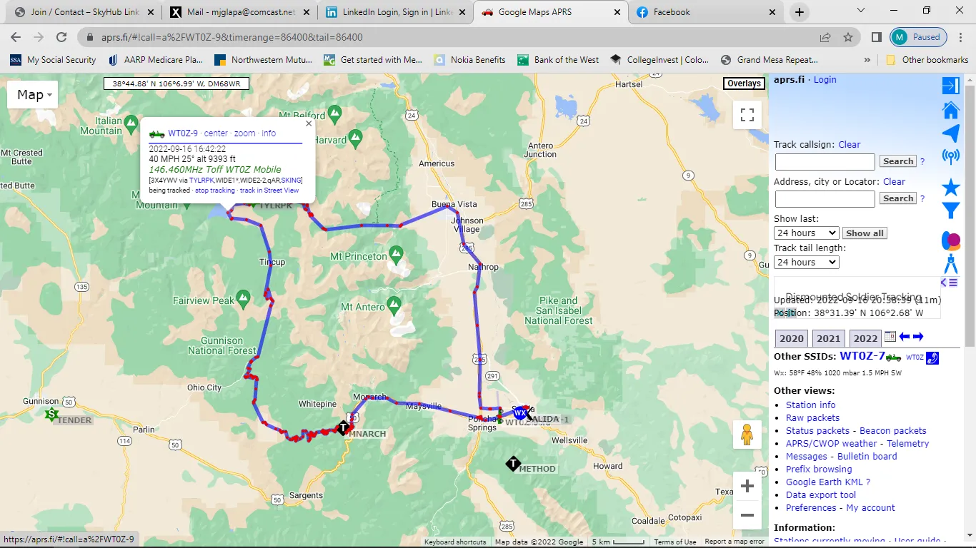
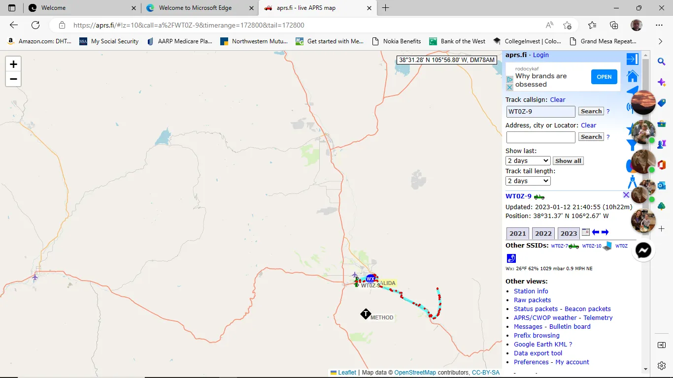
mjglapa
Jan 13, 2023, 12:16:05 PM1/13/23
to apr...@googlegroups.com, mjg...@gmail.com
Just FYI
Seeing much less detail now than before on aprs.fi. For my application, detail is important. I live in a rural area. First attachment shows screenshot of tracking from several months ago, second attachment shows screenshot in same geographic area from yesterday.
Marty
WT0Z-9
Sent via the Samsung Galaxy A13 5G,an AT&T 5G smartphone
--
You received this message because you are subscribed to the Google Groups "aprs.fi" group.
To unsubscribe from this group and stop receiving emails from it, send an email to aprsfi+un...@googlegroups.com.
You received this message because you are subscribed to the Google Groups "aprs.fi" group.
To unsubscribe from this group and stop receiving emails from it, send an email to aprsfi+un...@googlegroups.com.
To view this discussion on the web visit https://groups.google.com/d/msgid/aprsfi/alpine.DEB.2.21.2301131610450.8122%40jazz2.he.fi.
Nosey Nick VA3NNW
Jan 13, 2023, 12:16:57 PM1/13/23
to aprs.fi
oh6for wrote:
As a active contributor to OSM, I would also like to point out as you say.
That area's lacking data in OSM, are a very fixable problem :).
What comes to Finland at least, we have exceptionally good, open-data too, for most of the needs.
I like to compare a local church on google vs OSM:
Google: Has a perfectly good outline of the church, a church symbol, the church name, the car park, including both rows of spaces and connecting roads to the main road, shows the footpath running up the side of the property, all looks perfectly adequate.
OSM: As above but perhaps a more accurate building outline. Also notes that this is a multi-denominational church, clarifies both denominations and both names for the same church, both searchable. Mentions the girl guide troop that meets there weekly. Includes the number of parking spaces (they are unmarked, but the number is close enough). Between the car park and the footpath, also shows the connecting path, and the staircase, and notes that there are SEVEN steps. :-O
YES OSM also has a few poorly mapped rural areas, but the great thing about OSM is it's also the "Wikipedia of maps" - if it's missing something, or wrong, YOU can edit it! It helps if you can drive it once and upload your GPS track, you might even be able to work out how to get your APRS track into it (*), but otherwise you can overlay one of the free-to-use sat maps and just "freehand it". I imagine aprs.fi's tileserver will then pick up your edits within ... about a week?
(*) Now THERE'S an interesting question / feature request - does APRS.fi offer GPX / similar export? :-)
Nick VA3NNW

Andy Coetzee
Jan 13, 2023, 12:18:36 PM1/13/23
to aprs.fi
Uncaught ReferenceError: google is not defined
at (index):320:1
lib.js:5 loading leaflet, t_now 1673625294
lib.js:5 loading common
lib.js:5 init_map_common
lib.js:5 timerange_set 3600 with t_start undefined
lib.js:5 range_set(3600): 2
lib.js:5 range_set(3600): 3
lib.js:5 show_others_set: 1 => undefined
lib.js:5 reload_timerange
lib.js:5 starting leaflet
lib.js:5 starting point: none - using js hardcoded Helsinki
lib.js:5 load time init_map end: 378
lib.js:5 load done
lib.js:5 loaded
lib.js:5 leaflet deferred executed
lib.js:5 upd_bounds set, setting lastupd_bounds: 23.84445190429688,59.87061965367043,26.06918334960938,60.50488365760671
maps_leaflet.js:160 Uncaught TypeError: Cannot read properties of undefined (reading '4')
at it (maps_leaflet.js:160:102)
at eval (eval at execute_xml (lib.js:77:111), <anonymous>:1:1)
at execute_xml (lib.js:77:111)
at Object.Xlj [as success] (maps_leaflet.js:198:159)
at j (jquery.js:3148:30)
at Object.fireWith [as resolveWith] (jquery.js:3260:7)
at x (jquery.js:9314:14)
at XMLHttpRequest.b (jquery.js:9718:8)
amp-inabox.js:129 Powered by AMP ⚡ HTML – Version 2211111611000 https://aprs.fi/
amp-inabox.js:129 Powered by AMP ⚡ HTML – Version 2211111611000 https://aprs.fi/
amp-ad-exit.js:439 Unrecognized feature: 'attribution-reporting'.
detectAttributionReportingSupport @ amp-ad-exit.js:439
amp-ad-exit.js:439 Unrecognized feature: 'attribution-reporting'.
detectAttributionReportingSupport @ amp-ad-exit.js:439
DevTools failed to load source map: Could not load content for https://aprs.fi/js/ext/bootstrap.min.js.map: HTTP error: status code 404, net::ERR_HTTP_RESPONSE_CODE_FAILURE
DevTools failed to load source map: Could not load content for https://aprs.fi/css/ext/bootstrap.min.css.map: HTTP error: status code 404, net::ERR_HTTP_RESPONSE_CODE_FAILURE
DevTools failed to load source map: Could not load content for https://aprs.fi/css/ext/bootstrap-reboot.min.css.map: HTTP error: status code 404, net::ERR_HTTP_RESPONSE_CODE_FAILURE
Heikki Hannikainen
Jan 13, 2023, 12:29:44 PM1/13/23
to apr...@googlegroups.com
On Fri, 13 Jan 2023, mjglapa wrote:
> Just FYI
>
> Seeing much less detail now than before on aprs.fi. For my application,
> detail is important. I live in a rural area. First attachment shows
> screenshot of tracking from several months ago, second attachment shows
> screenshot in same geographic area from yesterday.
The names of cities and towns should make a comeback in the near future
> Just FYI
>
> Seeing much less detail now than before on aprs.fi. For my application,
> detail is important. I live in a rural area. First attachment shows
> screenshot of tracking from several months ago, second attachment shows
> screenshot in same geographic area from yesterday.
when I fix the data filtering and reload the OSM data set in the tile
server database.
Topographic data is not available in the OSM data, so unfortunately that
won't be available while Leaflet / OSM mapping is used. Unless maybe if
someone eventually improves the tile server software to incorporate one of
the public elevation data sets, and it doesn't have a terrible performance
impact.
But I hope we can have Google Maps available again later on, we'll see. At
this point I just need to confirm the OSM option works on some level, as I
can't afford paying a four-digit sum monthly for Google Maps.
- Hessu
Heikki Hannikainen
Jan 13, 2023, 12:31:15 PM1/13/23
to aprs.fi
On Fri, 13 Jan 2023, Nosey Nick VA3NNW wrote:
> (*) Now THERE'S an interesting question / feature request - does APRS.fi offer GPX / similar export? :-)
https://aprs.fi/doc/guide/aprsfi-exporting-data.html
> (*) Now THERE'S an interesting question / feature request - does APRS.fi offer GPX / similar export? :-)
https://aprs.fi/export/
Not GPX though, and the data collection interval on APRS might not be so
great for OSM work.
- Hessu
Heikki Hannikainen
Jan 13, 2023, 12:48:01 PM1/13/23
to aprs.fi
On Fri, 13 Jan 2023, Andy Coetzee wrote:
> Uncaught ReferenceError: google is not defined
> at (index):320:1
> Uncaught ReferenceError: google is not defined
> at (index):320:1
> > I am having the same issue here with Crome. It started here when I
> > turned on my computer yesterday.
Hey, thank you, that trace was useful. Please try again now, I think I
> > turned on my computer yesterday.
found and fixed the bug!
- Hessu
Nosey Nick VA3NNW
Jan 13, 2023, 2:47:42 PM1/13/23
to aprs.fi
> Not GPX though, and the data collection interval on APRS might not be so
> great for OSM work.
KMZ would do, and plenty of tools will convert KMZ to GPX or other more "open" standards.
I wasn't expecting APRS to be ideal, but perhaps slightly better than nothing if you are the first to drive an unmarked road on OSM.
For other Qs about topo... What does https://www.osmand.net/blog/topo-style/ use?
Nick VA3NNW
Todd Dugdale
Jan 13, 2023, 7:51:49 PM1/13/23
to aprs.fi
Later in the evening it started working. I now get OSM maps (like in APRSIS32).
Once you get outside the MSP metro, there are no towns marked. But I'm getting what I'm paying for.
Todd Dugdale
KD0TLS
Plymouth, MN
Randy Nelson
Jan 14, 2023, 3:35:19 AM1/14/23
to aprs.fi
Chrome is working now, thanks.

Darcy Buskermolen
Jan 14, 2023, 3:35:50 AM1/14/23
to apr...@googlegroups.com
On Fri, Jan 13, 2023, 12:29 p.m. Heikki Hannikainen <he...@hes.iki.fi> wrote:
On Fri, 13 Jan 2023, mjglapa wrote:
> Just FYI
>
> Seeing much less detail now than before on aprs.fi. For my application,
> detail is important. I live in a rural area. First attachment shows
> screenshot of tracking from several months ago, second attachment shows
> screenshot in same geographic area from yesterday.
The names of cities and towns should make a comeback in the near future
when I fix the data filtering and reload the OSM data set in the tile
server database.
Topographic data is not available in the OSM data, so unfortunately that
won't be available while Leaflet / OSM mapping is used. Unless maybe if
someone eventually improves the tile server software to incorporate one of
the public elevation data sets, and it doesn't have a terrible performance
impact.
If you move to using vector tiles then topo with 2.5d is certainly possible. Also with vector maps, the map tiles are rendered client side, supporting may diffrent style sheets if very possible. (Light mode, dark mode,.....) a further bonus to this is that serving vector tiles is a lot less intensive on the server side of things.
But I hope we can have Google Maps available again later on, we'll see. At
this point I just need to confirm the OSM option works on some level, as I
can't afford paying a four-digit sum monthly for Google Maps.
- Hessu
--
You received this message because you are subscribed to the Google Groups "aprs.fi" group.
To unsubscribe from this group and stop receiving emails from it, send an email to aprsfi+un...@googlegroups.com.
To view this discussion on the web visit https://groups.google.com/d/msgid/aprsfi/alpine.DEB.2.21.2301131922430.8122%40jazz2.he.fi.
Wayne Mahnker
Jan 14, 2023, 8:47:49 AM1/14/23
to aprs.fi
Crome is working now.
Darn Google's expensive cost for map usage. I now understand the reason for change. Good luck on providing back some of the past features.
Wayne
WA5LUY
Todd Dugdale
Jan 14, 2023, 3:22:20 PM1/14/23
to aprs.fi
Could you post a link for donations? I've looked around the site a bit and didn't find one.
I'm already sending you an annual donation, but I was unable to find a way to change that to monthly on PayPal. I just got lucky and saw the donation link on one of the rotating ads previously.
Have you considered a subscription option for upgraded service (e.g. Google Maps, increased retention time, exclusive server. etc)?
Todd D.
KD0TLS
Plymouth, MN
On Friday, 13 January 2023 at 06:13:02 UTC-6 Heikki Hannikainen wrote:
Andy Coetzee
Jan 16, 2023, 5:07:45 AM1/16/23
to aprs.fi
Hi Heikki,
lib.js:5 range_set(3600): 2
lib.js:5 range_set(3600): 3
lib.js:5 show_others_set: 1 => undefined
lib.js:5 range_set(3600): 2
lib.js:5 range_set(3600): 3
lib.js:5 show_others_set: 1 => undefined
lib.js:5 reload_timerange
lib.js:5 starting leaflet
lib.js:5 load done
lib.js:5 loaded
lib.js:5 leaflet deferred executed
amp-inabox.js:129 Powered by AMP ⚡ HTML – Version 2211111611000 https://aprs.fi/
amp-inabox.js:129 Powered by AMP ⚡ HTML – Version 2211111611000 https://aprs.fi/
amp-ad-exit.js:439 Unrecognized feature: 'attribution-reporting'.
detectAttributionReportingSupport @ amp-ad-exit.js:439
amp-ad-exit.js:439 Unrecognized feature: 'attribution-reporting'.
detectAttributionReportingSupport @ amp-ad-exit.js:439
Working way better, think you have found the problem:
o load source map: Could not load content for https://aprs.fi/js/ext/bootstrap.min.js.map: HTTP error: status code 404, net::ERR_HTTP_RESPONSE_CODE_FAILURE
DevTools failed to load source map: Could not load content for https://aprs.fi/css/ext/bootstrap.min.css.map: HTTP error: status code 404, net::ERR_HTTP_RESPONSE_CODE_FAILURE
DevTools failed to load source map: Could not load content for https://aprs.fi/css/ext/bootstrap-reboot.min.css.map: HTTP error: status code 404, net::ERR_HTTP_RESPONSE_CODE_FAILURE
lib.js:5 loading leaflet, t_now 1673860122
lib.js:5 loading common
lib.js:5 anchor_check: has 'z', zooming to 11
lib.js:5 anchor_check: has lat&lng, panning to 52.0685 -2.3353
lib.js:5 timerange_set 3600 with t_start 0
lib.js:5 loading common
lib.js:5 anchor_check: has 'z', zooming to 11
lib.js:5 anchor_check: has lat&lng, panning to 52.0685 -2.3353
lib.js:5 timerange_set 3600 with t_start 0
lib.js:5 range_set(3600): 2
lib.js:5 range_set(3600): 3
lib.js:5 show_others_set: 1 => undefined
lib.js:5 anchor_check done
lib.js:5 init_map_common
lib.js:5 timerange_set 3600 with t_start 0
lib.js:5 init_map_common
lib.js:5 timerange_set 3600 with t_start 0
lib.js:5 range_set(3600): 2
lib.js:5 range_set(3600): 3
lib.js:5 show_others_set: 1 => undefined
lib.js:5 reload_timerange
lib.js:5 starting leaflet
lib.js:5 starting point in vars: 52.0685 -2.3353
lib.js:5 load time init_map end: 490
lib.js:5 load time init_map end: 490
lib.js:5 load done
lib.js:5 loaded
lib.js:5 leaflet deferred executed
lib.js:5 upd_bounds set, setting lastupd_bounds: -2.8365325927734375,51.67576406810642,-1.8340301513671882,52.46001882122404
lib.js:5 redrawing, force: undefined last_expired 1673860122
lib.js:5 redrawing, force: undefined last_expired 1673860122
amp-inabox.js:129 Powered by AMP ⚡ HTML – Version 2211111611000 https://aprs.fi/
amp-inabox.js:129 Powered by AMP ⚡ HTML – Version 2211111611000 https://aprs.fi/
amp-ad-exit.js:439 Unrecognized feature: 'attribution-reporting'.
detectAttributionReportingSupport @ amp-ad-exit.js:439
et @ amp-ad-exit.js:103
ge @ custom-element.js:1317
Ws @ custom-element.js:1250
upgrade @ custom-element.js:379
Ir @ custom-element-registry.js:97
br @ custom-element-registry.js:82
(anonymous) @ custom-element-registry.js:40
ka @ extensions-impl.js:390
Ca @ extensions-impl.js:378
(anonymous) @ extensions-impl.js:340
addDocFactory @ extensions-impl.js:445
addElement @ extensions-impl.js:339
(anonymous) @ amp-ad-exit.js:582
f @ amp-ad-exit.js:582
registerExtension @ extensions-impl.js:162
(anonymous) @ runtime.js:205
Promise.then (async)
(anonymous) @ runtime.js:201
us @ chunk.js:190
vs @ chunk.js:409
(anonymous) @ chunk.js:465
Promise.then (async)
ws @ chunk.js:464
Ms @ chunk.js:483
(anonymous) @ chunk.js:435
Promise.then (async)
vs @ chunk.js:424
(anonymous) @ chunk.js:465
Promise.then (async)
ws @ chunk.js:464
Ms @ chunk.js:483
(anonymous) @ chunk.js:435
Promise.then (async)
vs @ chunk.js:424
(anonymous) @ chunk.js:465
Promise.then (async)
ws @ chunk.js:464
Ms @ chunk.js:483
Rs @ chunk.js:368
runForStartup @ chunk.js:357
Zn @ chunk.js:59
(anonymous) @ runtime.js:315
h @ runtime.js:216
(anonymous) @ runtime.js:257
(anonymous) @ timer-impl.js:71
setTimeout (async)
delay @ timer-impl.js:77
(anonymous) @ runtime.js:510
Dh @ runtime.js:239
(anonymous) @ runtime.js:326
us @ chunk.js:190
vs @ chunk.js:409
(anonymous) @ chunk.js:465
Promise.then (async)
ws @ chunk.js:464
Ms @ chunk.js:483
(anonymous) @ chunk.js:435
Promise.then (async)
vs @ chunk.js:424
(anonymous) @ chunk.js:465
Promise.then (async)
ws @ chunk.js:464
Ms @ chunk.js:483
(anonymous) @ chunk.js:435
Promise.then (async)
vs @ chunk.js:424
(anonymous) @ chunk.js:465
Promise.then (async)
ws @ chunk.js:464
Ms @ chunk.js:483
(anonymous) @ chunk.js:435
Promise.then (async)
vs @ chunk.js:424
(anonymous) @ chunk.js:465
Promise.then (async)
ws @ chunk.js:464
Ms @ chunk.js:483
Rs @ chunk.js:368
runForStartup @ chunk.js:357
Zn @ chunk.js:59
(anonymous) @ amp-inabox.js:64
(anonymous) @ version.js:11
amp-ad-exit.js:439 Unrecognized feature: 'attribution-reporting'.
detectAttributionReportingSupport @ amp-ad-exit.js:439
et @ amp-ad-exit.js:103
ge @ custom-element.js:1317
Ws @ custom-element.js:1250
upgrade @ custom-element.js:379
Ir @ custom-element-registry.js:97
br @ custom-element-registry.js:82
(anonymous) @ custom-element-registry.js:40
ka @ extensions-impl.js:390
Ca @ extensions-impl.js:378
(anonymous) @ extensions-impl.js:340
addDocFactory @ extensions-impl.js:445
addElement @ extensions-impl.js:339
(anonymous) @ amp-ad-exit.js:582
f @ amp-ad-exit.js:582
registerExtension @ extensions-impl.js:162
(anonymous) @ runtime.js:205
Promise.then (async)
(anonymous) @ runtime.js:201
us @ chunk.js:190
vs @ chunk.js:409
(anonymous) @ chunk.js:465
Promise.then (async)
ws @ chunk.js:464
Ms @ chunk.js:483
(anonymous) @ chunk.js:435
Promise.then (async)
vs @ chunk.js:424
(anonymous) @ chunk.js:465
Promise.then (async)
ws @ chunk.js:464
Ms @ chunk.js:483
Rs @ chunk.js:368
runForStartup @ chunk.js:357
Zn @ chunk.js:59
(anonymous) @ runtime.js:315
h @ runtime.js:216
(anonymous) @ runtime.js:257
(anonymous) @ timer-impl.js:71
setTimeout (async)
delay @ timer-impl.js:77
(anonymous) @ runtime.js:510
Dh @ runtime.js:239
(anonymous) @ runtime.js:326
us @ chunk.js:190
vs @ chunk.js:409
(anonymous) @ chunk.js:465
Promise.then (async)
ws @ chunk.js:464
Ms @ chunk.js:483
(anonymous) @ chunk.js:435
Promise.then (async)
vs @ chunk.js:424
(anonymous) @ chunk.js:465
Promise.then (async)
ws @ chunk.js:464
Ms @ chunk.js:483
(anonymous) @ chunk.js:435
Promise.then (async)
vs @ chunk.js:424
(anonymous) @ chunk.js:465
Promise.then (async)
ws @ chunk.js:464
Ms @ chunk.js:483
(anonymous) @ chunk.js:435
Promise.then (async)
vs @ chunk.js:424
(anonymous) @ chunk.js:465
Promise.then (async)
ws @ chunk.js:464
Ms @ chunk.js:483
Rs @ chunk.js:368
runForStartup @ chunk.js:357
Zn @ chunk.js:59
(anonymous) @ amp-inabox.js:64
(anonymous) @ version.js:11
lib.js:5 redrawing, force:
Don Rolph
Jan 18, 2023, 9:05:31 PM1/18/23
to apr...@googlegroups.com
I am finding the OSM map to be quite acceptable.
- Hessu
--
You received this message because you are subscribed to the Google Groups "aprs.fi" group.
To unsubscribe from this group and stop receiving emails from it, send an email to aprsfi+un...@googlegroups.com.
To view this discussion on the web visit https://groups.google.com/d/msgid/aprsfi/alpine.DEB.2.21.2301120052350.23380%40jazz2.he.fi.
AB1PH
Don Rolph

Mike, OE3MZC
Jan 27, 2023, 12:16:50 PM1/27/23
to aprs.fi
Hi Hessu,
apreciate all your good work on aprs.fi.
But does this mean; we will never get the useful selection of different map layers back again? I have been using it for TERRAIN visualisation and others.
I also tracking Amateurs in remote areas, like Africa (OE3SEU-9) sending APRS via our satellite QO-100 from near Kilimanjaro in Tansania and OSM maps are somehow not very detailed here.
So I understand the reason for this decision against a high Google bill, but there seem to be some downsides too.
(besides all the work it causes to you)
73 de Mike, OE3MZC / KW4XC
Heikki Hannikainen
Jan 27, 2023, 7:39:22 PM1/27/23
to aprs.fi
Hi,
Correct, OSM is better in some areas, but it doesn't offer all those other
layers, and in some areas the plain map data is also better on Google
Maps. Perhaps at some point I can find replacement solutions, but it'll
take time.
I wouldn't say "never", it might still be possible to run on Google Maps
as well. It depends on the level and stability of the free use credits I
get from Google in the future - I still have the possibility to use it,
but the monthly credits might not cover a full month, so I might have to
switch back to OSM for the last 1 or 2 weeks every month to not get a
bill. That'd be fun - you'd get a different mapping system depending on
which day it is.
Or I may have to spend a lot more time to rework the aprs.fi web site to
work more like a single-page application (SPA), and do less map view
loads, to reduce the charges. I'm not sure if I can find the time to do
that in the near future. Or maybe make it default to OSM and require users
to do some additional clickety-clicking to go to Google Maps, which would
again reduce the use of it.
At this point I'm just making sure that it is possible to run with OSM in
practice, so that there is a continuity plan if it becomes impossible to
use Google Maps in the long term.
On the upside, Google already did a reverse charge for the Large Bill I
got for usage in December, so I got that money back! I just need to make
sure I won't get any more of those.
On Fri, 27 Jan 2023, Mike, OE3MZC wrote:
> Hi Hessu,apreciate all your good work on aprs.fi.
>
>
- Hessu

Mateusz SP8EBC
Jan 28, 2023, 1:50:09 AM1/28/23
to aprs.fi
Hi Hekki,
I think a solution to that problem might be adding another OSM layer to choose from. At least in my area (JN99MT) CyclOSM works much better. It has land form with a lot of details and great resolution of contour lines etc. Standard OSM doesn't work at all in the mountains especially that on APRS.FI it lacks few class of objects, like borders etc.
// ML
Heikki Hannikainen
Jan 28, 2023, 2:06:21 AM1/28/23
to aprs.fi
On Fri, 27 Jan 2023, Mateusz SP8EBC wrote:
> I think a solution to that problem might be adding another OSM layer to
> choose from. At least in my area (JN99MT) CyclOSM works much better.
Right, but as I currently have to run my own OSM tile server, which
> I think a solution to that problem might be adding another OSM layer to
> choose from. At least in my area (JN99MT) CyclOSM works much better.
generates the raw PNG images for your browser, and only hosts the data for
this single layer, it's not that simple.
It's a server with 128G of memory and 16 CPU cores, two SSDs in RAID0 for
the data (if it fails I can just download a new copy). If I'd add a lot of
detail or more layers I'd have to rent a larger server, and it costs more.
I'm not loading all OSM details (buildings, amenities, lamp posts...) in
the PostgreSQL GIS database which is used to generate the tiles, so that
it runs fast enough on this small server. It's still quite sluggish for
some time after the data is updated.
It's a possible path at some point. If someone else lets me use their tile
service, that's easier of course.
- Hessu
Mike, OE3MZC
Feb 5, 2023, 12:39:11 PM2/5/23
to aprs.fi
Hi,
thank you for long answer and explaination.
So whenever you see a chance to get the old Google layers back into aprs.fi, I would appreciate.
It is also about the Satellite view and Terraine views...
Let me say again big THANK YOU for all the extremely professional work, you are doing on this site aprs.fi.
I have now checked out all alternatives and found nothing that would be comparable with your service...
73 de Mike OE3MZC / KW4XC
President of ICSSW-AMSAT-OE
Mateusz SP8EBC
Feb 6, 2023, 1:47:45 PM2/6/23
to aprs.fi
Hi,
So maybe replace existing OSM layer with that CycleOSM or somethinf like that ? Don't get me wrong, but now aprs.fi is quite unusable in my area. There are too less details on the map. For instance please look at neighbourhood of SR9WXP station.
// ML
Heikki Hannikainen
Feb 6, 2023, 2:25:13 PM2/6/23
to aprs.fi
On Mon, 6 Feb 2023, Mateusz SP8EBC wrote:
> So maybe replace existing OSM layer with that CycleOSM or somethinf like that ? Don't get me wrong, but now aprs.fi is
> quite unusable in my area. There are too less details on the map. For instance please look at neighbourhood of SR9WXP
> station.
If CyclOSM has a lot more details, it will be larger, and will probably
> So maybe replace existing OSM layer with that CycleOSM or somethinf like that ? Don't get me wrong, but now aprs.fi is
> quite unusable in my area. There are too less details on the map. For instance please look at neighbourhood of SR9WXP
> station.
not fit on the server I have. They have a tile server, but it's under the
same policy (https://operations.osmfoundation.org/policies/tiles/).
- Hessu

mike moore
Feb 11, 2023, 10:28:25 AM2/11/23
to aprs.fi
In Rochester New York we use aprs.fi for our public service events. Two of the events that we support are bike rides and we overlay the bike routes in different colors over the aprs.fi map by specifying the center point, zoom level, and include a kml file pointer that details the bike route. The map then shows the route with our support vehicles on the route in our command center. The kml file overlay does not appear to be a part of the OSM implementation currently. Does anyone have an idea about how we can implement the route map in the present scheme?
73, KC2NM
Nosey Nick VA3NNW
Feb 12, 2023, 6:52:31 AM2/12/23
to aprs.fi
Leaflet has good support for GeoJSON. There are various plugins for GPX, and yes even KML, though KML is a bit google-specific. I bet Hessu could expose one/some of the above at some point?
Heikki Hannikainen
Feb 12, 2023, 3:09:00 PM2/12/23
to aprs.fi
Hi,
Yes, I could add parameters to load GeoJSON. The Google Maps API supports
GeoJSON these days too, so it should be possible to support it on both.
I cannot commit to a timeline at this time.
> --
> You received this message because you are subscribed to the Google Groups "aprs.fi" group.
> To unsubscribe from this group and stop receiving emails from it, send an email to aprsfi+un...@googlegroups.com.
> To view this discussion on the web visit https://groups.google.com/d/msgid/aprsfi/eef261d6-ace2-4c04-8e2d-17a81698e475n%40googlegroups.com.
> You received this message because you are subscribed to the Google Groups "aprs.fi" group.
> To unsubscribe from this group and stop receiving emails from it, send an email to aprsfi+un...@googlegroups.com.
>
>
- Hessu
Reply all
Reply to author
Forward
0 new messages