User defined shapes?
110 views
Skip to first unread message

Simon Roberts
Sep 24, 2021, 7:16:05 PM9/24/21
to Apps4Av Forum
I've succeed in getting Avare to display user defined points in a KML file, but I just tried to define a shape (actually just a line) the same way, and it's ignored.
I think I remember a discussion about shapes, but I have failed to find it here. Can anyone tell me how to achieve this (if indeed it's possible?)
Cheers,
Simon

Dana
Oct 12, 2021, 6:49:01 PM10/12/21
to Apps4Av Forum
I'd be interested in this too. I'd like to be able to depict a couple of areas near my home field where aerobatics are legal (4 NM from the centerline of any federal airway).

Eric Tamme
Jan 18, 2022, 10:57:06 PM1/18/22
to Apps4Av Forum
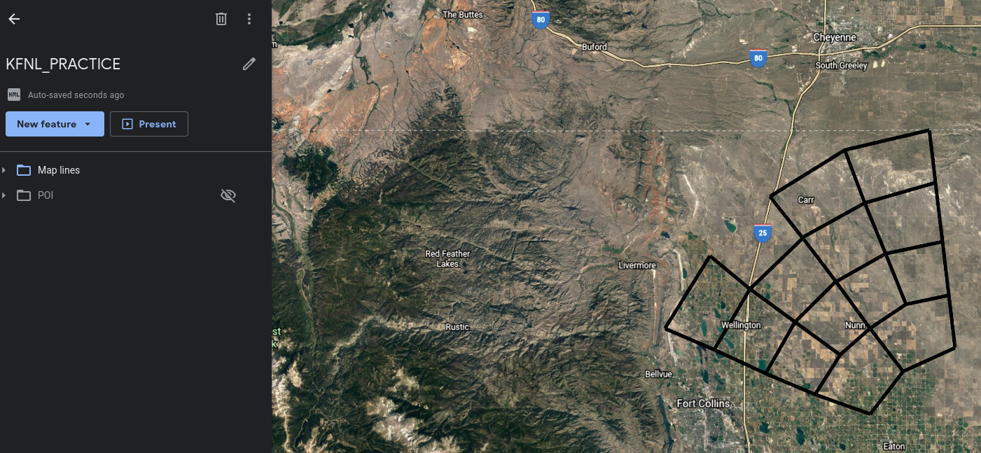
Bump here - my flight school uses a KML that makes up a practice area (well a
set of them really) which is a series of lines following radials off a
VOR, and some outer arcs at 10 mile intervals. All of this seems
totally ignored by Avare. If I instead mark each line intersection with
a point ... it works, but its quite unruly looking. I'd love for Avare
to be able to overlay lines or shapes, not just "points" - is this currently possible?

t v
Jan 19, 2022, 1:29:36 PM1/19/22
to Apps4Av Forum
I'd love for Avare
to be able to overlay lines or shapes, not just "points" - is this currently possible?
Hi.
You can accomplish the same thing many different ways in Avare, and that was one the reasons I use Avare for in training.
When you fly a pattern save the Track / Screen and and Reload / Tag, see below. Recently there have been problems with the T in older AOS version, test it first.
Use a Flight simulator to create your Pattern on any georeferenced chart save and Tag, see below.
Just Copy the screen, if the Map is georeferenced, with the Practice area you want Save it as CUSTOM in your nearby Airport Plate (within 25NM) and Tag it. When you need it jut load it. SEE some old posts about CAP and you can also use the Draw, Create distance points from Radials in Find, create and reload flight plans... TV
Eric Tamme
Jan 19, 2022, 4:15:07 PM1/19/22
to Apps4Av Forum
I don't understand any of your potential solutions, please forgive me. Saving a track is the same thing as uploading a KML with a "breadcrumb" of points of interest, is it not? I have seen other posts where people create a KML of points, but avare does not render a "line" for the track if it is not varying elevation. I don't want to have to "fly" a track in the simulator, I want to lay it out on a sectional, and use the KML from that.
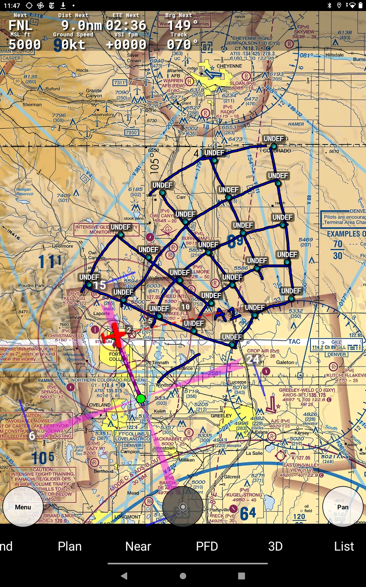
Re: Drawing, yes you can draw, and that is what I have done... import the KML with each line intersection as a POI, then I draw lines to connect them...(see screnshot below) this "works" but its fiddly and not very good because there is no undo, no save, etc. all you have to do is hit clear by mistake once and its gone.
Re: creating distance points from radials in find and create flight plans ... I looked in here and can't figure out anything that relates to what you described. Can you please provide more verbose descriptions of your solutions? I've read the avare manual and it does not have much information on the subject other than setting the data directory for which to read tracks from.
Re: creating distance points from radials in find and create flight plans ... I looked in here and can't figure out anything that relates to what you described. Can you please provide more verbose descriptions of your solutions? I've read the avare manual and it does not have much information on the subject other than setting the data directory for which to read tracks from.
Thank you,
Eric
t v
Jan 19, 2022, 6:03:11 PM1/19/22
to Apps4Av Forum
Hi Eric and everyone.
A quick response, you may be on the East Coast and I will not be able to respond with more details until much later tonight, to:
>>Re: creating distance points from radials in find and create flight plans ...<<
Here is some info from Menu>Help...
"You can also specify radial/DME pairs in destination like BOS275010 for BOS VOR, 275 degree radial, 10 miles."
"You can also specify radial/DME pairs in destination like BOS275010 for BOS VOR, 275 degree radial, 10 miles."
I personally think that only You, Me, Z and a maybe couple of others / Instructors may be interested in this discussion but your best solution may be to use the CUSTOM Plate 25NM distance solution? Do a Search for CAP for more details. Assuming Tag still works? I did not use it in a while and many changes have taken place recently. TV

Jim Roberts
Jan 20, 2022, 11:24:36 AM1/20/22
to Apps4Av Forum
https://anyconv.com/kml-to-gpx-converter then download to your user defined waypoints file. You can then load it from the plans tab and make it active.
Reply all
Reply to author
Forward
0 new messages