MapView Plugin

ECEisLife

Steve Garman
If so, how do I install it?
Steve Garman
Steve Garman
"map.ShowLocation is not a function"

wheelie tips
wheelie tips
wheelie tips
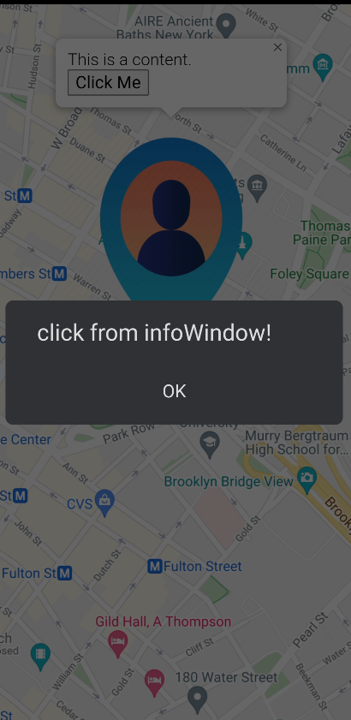
userInfo
= "<div style='float:left'><img src='http://i.stack.imgur.com/g672i.png'></div><div
style='float:right; padding: 10px;'><b>Title</b><br/>123
Address<br/> City,Country</div>"
infowindow
= map.CreateInfoWindow( userInfo, objPayload.latitude, objPayload.longitude,
false );
But that broke something and no infowindow pops when clicking the icon, using other tags like <b> and <br> work, but I couldn’t get the <img> tag to work; any suggestions on how to add an image to the infowindow (preferably a local image)?
Steve Garman
I'm sure you will get excellent support from Jumar as always but you might find it interesting to know that I have a little function I sometimes use as a callback when I find a callback I don't know what arguments are available and how many
It can't guess the names of the parameters but it tries to tell you as much as it can about each one
// DroidScript test callback
function testCallback()
{
var arg,argType,argVal;
var argc=arguments.length;
var ths = typeof this;
if(this && this.hasOwnProperty("GetType")&& typeof this.GetType=="function")
ths=this.GetType();
var msg="this is "+ ths;
if(argc==0) msg+="\nno arguments";
for(var i=0; i<argc; i++)
{
arg="p"+(i+1);
argType = typeof arguments[i];
if(argType=="object")
argVal=JSON.stringify(arguments[i]);
else argVal = arguments[i];
msg += "\n"+ arg+"("+argType+") = "+argVal;
}
alert(msg);
wheelie tips
wheelie tips
infoWindow.SetContent(info)
wheelie tips
wheelie tips
- center_changed
- click
- dblclickdrag
- dragend
- dragstart
wheelie tips
ECEisLife
wheelie tips
@Jumar
Thank you for your
reply!
I know that you are super busy with the new editor (I assume with other things too);I do appreciate you finding the time to reply.
I will draft a few examples for you tomorrow as my current code is too full to copy/paste an example.
Thanks again!
WT
wheelie tips
//Called when application is started.
function OnStart()
{
lay = app.CreateLayout("Absolute", "VCenter, FillXY");
// map stays in default view, no dark mode applied
map = app.CreateMapView(apiKey, 1, 1.07, 7, 125, 11, "DARKMAP");
map.SetOnReady(Map_OnReady);
lay.AddChild(map)
//Add layout to app.
app.AddLayout( lay );
}
function Map_OnReady()
{
console.log(">>>>>> Map_OnReady")
circle = map.CreateCircle(7, 125, 5000);
circle.SetDraggable(true);
circle.SetEditable(true);
circle.AddListener('dragend', 'On_CircleDragEnd');
circle.AddListener('center_changed','On_CircleCenterChanged');
circle.AddListener('radius_changed','On_CircleRadiusChanged');
}
function On_CircleDragEnd(e) {
console.log(">>>>>> On_CircleDragEnd " + e)
}
function On_CircleRadiusChanged(e) {
console.log(">>>>>> On_CircleRadiusChanged " + e)
}
function On_CircleCenterChanged(e) {
console.log(">>>>>> On_center_changed " + e)
}
///////////////////////////////////////////////////
ECEisLife
wheelie tips
ECEisLife
wheelie tips
@Jumar - many thanks for your email!
ECEisLife
wheelie tips
wheelie tips
wheelie tips
wheelie tips

Alan Hendry
Jumar
wheelie tips
wheelie tips
wheelie tips
wheelie tips
wheelie tips
var myMarkerGreen = "Img/green_map_marker_static.png"
myMarker.AddListener("click", "Show_Marker_Floating_Buttons")
{
lay_Contact_Member = app.CreateLayout("Absolute")
lay_Contact_Member.SetBackColor('yellow')
lay_Contact_Member.SetPosition(0.7, 0.3, 0.3, 0.6)
lay_Contact_Member.SetOnTouch(moveIt)
//Add layout to app.
app.AddLayout( lay_Contact_Member )
{
lay_Contact_Member.SetPosition(0.7, 0.3, 0.3, 0.6)
}/////////////////////////////////////////////////////////////
- App.CreateLayout( Absolute )
- -> #3
- Lay.SetBackColor( yellow )
- Obj.SetPosition( 0.7, 0.3, 0.3, 0.6, )
- Lay.SetOnTouch( moveIt )
- App.AddLayout( #3 )
- Obj.SetPosition( 0.7, 0.3, 0.3, 0.6, )
- WARNING: Obj.SetPosition() failed! (SetPosition only works in Absolute layouts!)
02-24 09:46:55.691 14915 14915 D Nxt : Web.Execute(♀CreateMarker('{"position":{"lat":0,"lng":0},"id":0}')♀null)
02-24 09:46:55.691 14915 14915 D Nxt : ->
02-24 09:46:55.693 14915 14915 D Nxt : Web.Execute(♀markers[0].setMap(map)♀null)
02-24 09:46:55.693 14915 14915 D Nxt : ->
02-24 09:46:55.696 14915 14915 D Nxt : Web.Execute(♀markers[0].SetIcon('{"url":"Img/green_map_marker_static.png","scaledSize":{"width":40,"height":40}}')♀null)
02-24 09:46:55.696 14915 14915 D Nxt : ->
02-24 09:46:55.699 14915 14915 D Nxt : Web.Execute(♀markers[0].SetPosition('{"lat":0,"lng":0}')♀null)
02-24 09:46:55.700 14915 14915 D Nxt : ->
02-24 09:46:55.702 14915 14915 D Nxt : Web.Execute(♀markers[0].AddEvent('click', 'Show_Marker_Floating_Buttons', 0)♀null)
02-24 09:46:55.702 14915 14915 D Nxt : ->
02-24 09:46:55.704 14915 14915 D Nxt : Web.Execute(♀map.PanTo('{"lat":0,"lng":0}')♀null)
02-24 09:46:55.705 14915 14915 D Nxt : ->
02-24 09:46:55.905 14915 14915 D Nxt : _UseDbg(♀false)
02-24 09:46:56.908 14915 14915 D Nxt : _UseDbg(♀false)
02-24 09:46:58.260 14915 14915 D Nxt : App.Execute(Show_Marker_Floating_Buttons('{"latLng":{"lat":0,"lng":0},"domEvent":{"isTrusted":true,"__gm_interna...)
02-24 09:46:58.261 14915 14915 D Nxt : Executing statement...
02-24 09:46:58.266 14915 14915 D Nxt : App.CreateLayout(Absolute♀undefined)
02-24 09:46:58.268 14915 14915 D Nxt : Object Count = 4
02-24 09:46:58.268 14915 14915 D Nxt : -> #3
02-24 09:46:58.270 14915 14915 D Nxt : Lay.SetBackColor(♀yellow)
02-24 09:46:58.271 14915 14915 D Nxt : Obj.SetPosition(♀0.7♀0.3♀0.3♀0.6♀undefined)
02-24 09:46:58.273 14915 14915 D Nxt : Lay.SetOnTouch(♀moveIt)
02-24 09:46:58.274 14915 14915 D Nxt : App.AddLayout(#3)
02-24 09:47:01.067 14915 14915 D Nxt : Firing activity event _Call('#3',moveIt,[{source:_map[\"#3\"],action:\"Down\",count:1,X:0.59488934,Y:0.8657014,screenX:0.1784668,screenY:0.5539675,rawX:192.74414,rawY:1208.2031,x:[0.59488934,0.0,0.0],y:[0.8657014,0.0,0.0]}])
02-24 09:47:01.071 14915 14915 D Nxt : Obj.SetPosition(♀0.7♀0.3♀0.3♀0.6♀undefined)
02-24 09:47:01.072 14915 14915 E Nxt : ------ ERROR: Script method failed ------
02-24 09:47:01.072 14915 14915 E Nxt : java.lang.Exception: SetPosition only works in Absolute layouts!
02-24 09:47:01.072 14915 14915 E Nxt : at com.smartphoneremote.ioioscript.IOIOScript.L(Unknown Source:15)
02-24 09:47:01.072 14915 14915 E Nxt : at com.smartphoneremote.ioioscript.ChromeClient.onJsPrompt(Unknown Source:18398)
02-24 09:47:01.072 14915 14915 E Nxt : at n9.run(chromium-TrichromeWebViewGoogle6432.aab-stable-475810134:7)
02-24 09:47:01.072 14915 14915 E Nxt : at android.os.Handler.handleCallback(Handler.java:938)
02-24 09:47:01.072 14915 14915 E Nxt : at android.os.Handler.dispatchMessage(Handler.java:99)
02-24 09:47:01.072 14915 14915 E Nxt : at android.os.Looper.loopOnce(Looper.java:226)
02-24 09:47:01.072 14915 14915 E Nxt : at android.os.Looper.loop(Looper.java:313)
02-24 09:47:01.072 14915 14915 E Nxt : at android.app.ActivityThread.main(ActivityThread.java:8582)
02-24 09:47:01.072 14915 14915 E Nxt : at java.lang.reflect.Method.invoke(Native Method)
02-24 09:47:01.072 14915 14915 E Nxt : at com.android.internal.os.RuntimeInit$MethodAndArgsCaller.run(RuntimeInit.java:563)
02-24 09:47:01.072 14915 14915 E Nxt : at com.android.internal.os.ZygoteInit.main(ZygoteInit.java:1133)
02-24 09:47:01.094 14915 14915 D Nxt : Firing activity event _Call('#3',moveIt,[{source:_map[\"#3\"],action:\"Move\",count:1,X:0.5995565,Y:0.8657014,screenX:0.17986694,screenY:0.5539675,rawX:194.2563,rawY:1208.2031,x:[0.5995565,0.0,0.0],y:[0.8657014,0.0,0.0]}])
Alan Hendry
wheelie tips
Many thanks!!
wheelie tips
featureType: "poi.business",
elementType: "all",
stylers: [ { visibility: "off" } ]
}
map.SetOptions ({zoomControl:false, styles:styles})
Jumar
featureType: "poi.business",
elementType: "all",
stylers: [ { visibility: "off" } ]
}
wheelie tips
Thank you for your reply!
wheelie tips
Best,
Jumar
wheelie tips
Jumar
styles: [
{
featureType: "poi",
elementType: "all",
stylers: [{ visibility: "off" } ]
{
featureType: "transit",
elementType: "all",
stylers: [{ visibility: "off" } ]
]
})
wheelie tips
Jumar
{elementType: 'geometry', stylers: [{color: '#242f3e'}]},
{elementType: 'labels.text.stroke', stylers: [{color: '#242f3e'}]},
{elementType: 'labels.text.fill', stylers: [{color: '#746855'}]},
{
featureType: 'administrative.locality',
elementType: 'labels.text.fill',
stylers: [{color: '#d59563'}]
},
{
featureType: 'poi',
elementType: 'labels.text.fill',
stylers: [{color: '#d59563'}]
},
{
featureType: 'poi.park',
elementType: 'geometry',
stylers: [{color: '#263c3f'}]
},
{
featureType: 'poi.park',
elementType: 'labels.text.fill',
stylers: [{color: '#6b9a76'}]
},
{
featureType: 'road',
elementType: 'geometry',
stylers: [{color: '#38414e'}]
},
{
featureType: 'road',
elementType: 'geometry.stroke',
stylers: [{color: '#212a37'}]
},
{
featureType: 'road',
elementType: 'labels.text.fill',
stylers: [{color: '#9ca5b3'}]
},
{
featureType: 'road.highway',
elementType: 'geometry',
stylers: [{color: '#746855'}]
},
{
featureType: 'road.highway',
elementType: 'geometry.stroke',
stylers: [{color: '#1f2835'}]
},
{
featureType: 'road.highway',
elementType: 'labels.text.fill',
stylers: [{color: '#f3d19c'}]
},
{
featureType: 'transit',
elementType: 'geometry',
stylers: [{color: '#2f3948'}]
},
{
featureType: 'transit.station',
elementType: 'labels.text.fill',
stylers: [{color: '#d59563'}]
},
{
featureType: 'water',
elementType: 'geometry',
stylers: [{color: '#17263c'}]
},
{
featureType: 'water',
elementType: 'labels.text.fill',
stylers: [{color: '#515c6d'}]
},
{
featureType: 'water',
elementType: 'labels.text.stroke',
stylers: [{color: '#17263c'}]
},
{
featureType: "poi.business",
elementType: "all",
stylers: [ { visibility: "off" } ]
}
wheelie tips
wheelie tips
wheelie tips
{
newPolygon.GetPath(function (e)
{
console.log(">>>>> getNewPolygonPath" ) // never fire
console.log(">>>>> " + e)
})
}
03-19 13:12:28.754 11217 11217 D Nxt : ->
03-19 13:12:28.756 11217 11217 D Nxt : Web.Execute(♀polygons[1].setMap(map)♀null)
03-19 13:12:28.756 11217 11217 D Nxt : ->
03-19 13:12:28.757 11217 11217 D Nxt : Web.Execute(♀polygons[1].setEditable(true)♀null)
03-19 13:12:28.757 11217 11217 D Nxt : ->
03-19 13:12:38.211 11217 11217 D Nxt : Firing activity event _Call('#3',getNewPolygonPath,[])
03-19 13:12:38.216 11217 11217 D Nxt : Web.Execute(♀polygons[1].Get('getPath')♀null)
03-19 13:12:38.217 11217 11217 D Nxt : ->
wheelie tips
Alan Hendry
wheelie tips
'event' and 'callback' parameter is a string
Jumar
Hi there Wheelie
wheelie tips
Good morning Jumar,
Thank you for the updated plugin!
After a couple of hours of testing, here are my findings:
When creating a new polygon and setting GetPath and SetEditable(true) :
newPolygon =
map.CreatePolygon(path, "#009688", 0.1, 5, "#009688", true)
newPolygon.GetPath(newPolygon_GetPath)
newPolygon.SetEditable(true)
function
newPolygon_GetPath( e )
{
console.log(">>
newPolygon_GetPath = " + e)
app.WriteFile('poly.json',
JSON.stringify(e))
}
The callback function “newPolygon_GetPath” is fired only once on the creation; from that moment on, the callback is not fired anymore.
Trying to set newPolygon.SetEditable(false) and then set the callback newPolygon.GetPaths(newPolygon_GetPath) after finishing editing the new polygon also doesn’t fire the callback.
I couldn’t addListener to the polygon path as they did in your link.
I’ve also tried to addListener to the polygon mouseup which did fire whenever a point on the edited polygon changed, but the callback returned only the latlng of that point (I tried to add those points to an array but if the user changes the same point twice, it causes differences between the array and the true polygon array )
If I understand correctly the problem is there’s an issue with getting the path of the polygon while editing it; this is not our need; we need to get the final path array of the edited polygon after the editing part has ended; so the question is how to get an existing polygon point array after it was edited and is no longer in edit mode?
Thanks again for taking the time to look into this issue, looking forward to solving this!!
Best,
WT
wheelie tips
Alan Hendry
wheelie tips
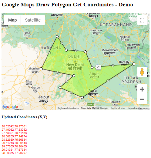
<head>
<title>Google Maps Draw Polygon Get Coordinates</title>
<script type="text/javascript" src="https://maps.googleapis.com/maps/api/js?key=YOUR-KEY"></script>
<script type="text/javascript">
var draggablePolygon; function InitMap() {
var location = new google.maps.LatLng(28.620585, 77.228609);
var mapOptions = {
zoom: 7,
center: location,
mapTypeId: google.maps.MapTypeId.RoadMap
};
var map = new google.maps.Map(document.getElementById('map-canvas'),
mapOptions);
var shapeCoordinates = [
new google.maps.LatLng(28.525416, 79.870605),
new google.maps.LatLng(27.190518, 77.530518),
new google.maps.LatLng(29.013807, 77.67334)
];
// Construct the polygon
draggablePolygon = new google.maps.Polygon({
paths: shapeCoordinates,
draggable: true,
editable: true,
strokeColor: '',
strokeOpacity: 0.8,
strokeWeight: 2,
fillColor: '#ADFF2F',
fillOpacity: 0.5
});
draggablePolygon.setMap(map);
google.maps.event.addListener(draggablePolygon, "dragend", Getpolygoncoordinates);
google.maps.event.addListener(draggablePolygon.getPath(), "insert_at", Getpolygoncoordinates);
google.maps.event.addListener(draggablePolygon.getPath(), "remove_at", Getpolygoncoordinates);
google.maps.event.addListener(draggablePolygon.getPath(), "set_at", Getpolygoncoordinates);
}
function Getpolygoncoordinates() {
var len = draggablePolygon.getPath().getLength();
var strArray = "";
for (var i = 0; i < len; i++) {
strArray += draggablePolygon.getPath().getAt(i).toUrlValue(5) + "<br>";
}
document.getElementById('info').innerHTML = strArray;
}
</script>
</head>
<body onload="InitMap();Getpolygoncoordinates();">
<h2>Google Maps Draw Polygon Get Coordinates - Demo</h2>
<div id="map-canvas" style="height: 400px; width: auto;"></div>
<h4>Updated Coordinates (X,Y)</h4>
<div id="info" style="position:absolute; color:red; font-family: Arial; height:200px; font-size: 12px;"></div>
</body>
</html>
//////////////////////////////////////////////////////////////

Erez Mor
wheelie tips
wheelie tips
- marker SetIcon cannot load images located at the root folder; the marker itself doesn't show without any error msg, same icon would be shown if located in the Img folder for ex.
- marker SetOptions seems to be broken, trying to format a label breaks the marker and it doesn't show, for ex.:
myMarker.SetOptions({color: "#eb3a44",fontSize: "44px",fontWeight: "bold"}) // I guess this is the correct way but not 100% sure
wheelie tips
map.FindPlaceByTextQuery(query, 52.48109315453335, -1.8989471566062308, 5000, null, OnResult)
wheelie tips
wheelie tips
wheelie tips
function circle_bounds( event )
{
console.log(event)
}
wheelie tips
rec.SetEditable(true)
wheelie tips
wheelie tips
Jumar
wheelie tips
wheelie tips
border = JSON.parse(app.ReadFile(' border.json'))
polygon = map.CreatePolygon( border , "#009688", 0.0001, 2, "#FF0000", true)
polygon.SetOptions({icons: [{icon: lineSymbol, offset: '0', repeat: '20px'}]})
const line = [{'lat':lat, 'lng':lng},{'lat':lat + 0.1, 'lng':lng + 0.1}]
polyBorder = map.CreatePolyline( line, null, '#EDFF14' )
polyBorder.SetOptions({icons: [{icon: lineSymbol, offset: '0', repeat: '20px'}]})
////////////////////////////////////////
Erez Mor
Alan Hendry
wheelie tips
wheelie tips
wheelie tips
circle.SetDraggable(true)
circle.SetDraggable(true)
circle.SetDraggable(false)
Alan Hendry
wheelie tips
Alan Hendry
wheelie tips
Alan Hendry
Jumar
Jumar
wheelie tips
Hi Jumar,
The following are open issues/questions accumulated over the last couple of months, is there any estimated time, if any, for those issues to be addressed?
newPolygon.GetPath
marker SetOptions
circle.GetBounds(circle_bounds)
circle.GetCenter(circle_center)
CreateRectangle
set
an anchor point
circle
SetDraggable
I really appreciate any help you can provide.
WT
Jumar
Jumar
Jumar
wheelie tips

Blaine Smith
Jumar
wheelie tips
I've tested the latest ver 1:10 against the open issues and this is my findings, please let me know if i have missed anything:
marker.SetOptions - not fixed
circle.GetBounds(circle_bounds) - FIXED!!
circle.GetCenter(circle_center) - FIXED!!
CreateRectangle - not fixed (also the link for it in the docs is broken)
set an anchor point - not fixed (i guess its part of the marker.SetOptions issue?)
wheelie tips
wheelie tips
Thx again,
WT
Jumar
Jumar
- Fixed marker.SetOptions
- Fixed polygon.GetPath for editable and draggable polygon
- Fixed polyline.GetPath for editable and draggable polyline
- Fixed broken rectangle docs link
function OnStart() {
lay = app.CreateLayout("Linear", "VCenter, FillXY");
var apiKey = "AIzaSyD2eHntKEmh272p3ac6YjWPbPkwo3m2mck";
map = app.CreateMapView(apiKey, 0.9, 0.5, 7.0689323, 125.6114588, 13);
map.SetOnReady(MapOnReady);
lay.AddChild(map);
btn = app.AddButton( lay, "GetPath" )
btn.SetOnTouch( function() {
app.Alert( JSON.stringify( polygon.GetPath() ) )
})
app.AddLayout(lay);
}
function MapOnReady() {
var path = [
{lat: 7.069226, lng: 125.604101},
{lat: 7.067352, lng: 125.608382},
{lat: 7.070056, lng: 125.610388},
{lat: 7.071771, lng: 125.607009}
];
polygon = map.CreatePolygon(path, "#009688", 0.1, 2, "#009688");
polygon.SetEditable( true )
}
Jumar
wheelie tips
Jumar
Jumar
label: { color: "#eb3a44",fontSize: "44px",fontWeight: "bold" }
}
myMarker.SetOptions( options )