Stereo Error: Permission denied
53 views
Skip to first unread message

sai venkat
Nov 3, 2021, 9:25:06 AM11/3/21
to Ames Stereo Pipeline Support
Hi all,
I'm trying to make a fine resolution (0.5m) DSM with Pleiades' Triple stereo imagery and a reference srtm dem of 30m. However, I'm experiencing trouble making dem from a reference image.
1. There are two options to provide dem, one is using pc_align tool and the other is using stereo.default file's parameter i.e., "disparity-estimation-dem" and "disparity-estimation-dem-error" with "corr-seed-mode 2". Here i am confused which one is the correct method to use. Also disparity-estimation-dem same as output of stereo--> followed by --> point2dem?
2. stereo output prints, "Warning: It appears that the input images are map-projected. In that case a DEM needs to be provided for stereo to give correct results." but the documentation says "corr-seed-mode 2 is not compatible with map projected input images." confused which one to follow.
Pls have a glance at documentation below.
2 - Low-resolution disparity from
an input DEM
Use a lower-resolution DEM together with an estimated value for its error to compute the low-resolution disparity, which will then be used to find the full-resolution disparity as above. These quantities can be specified via the options disparity-estimation-dem and disparity-estimation-dem-error respectively. This option is not compatible with map projected input images.
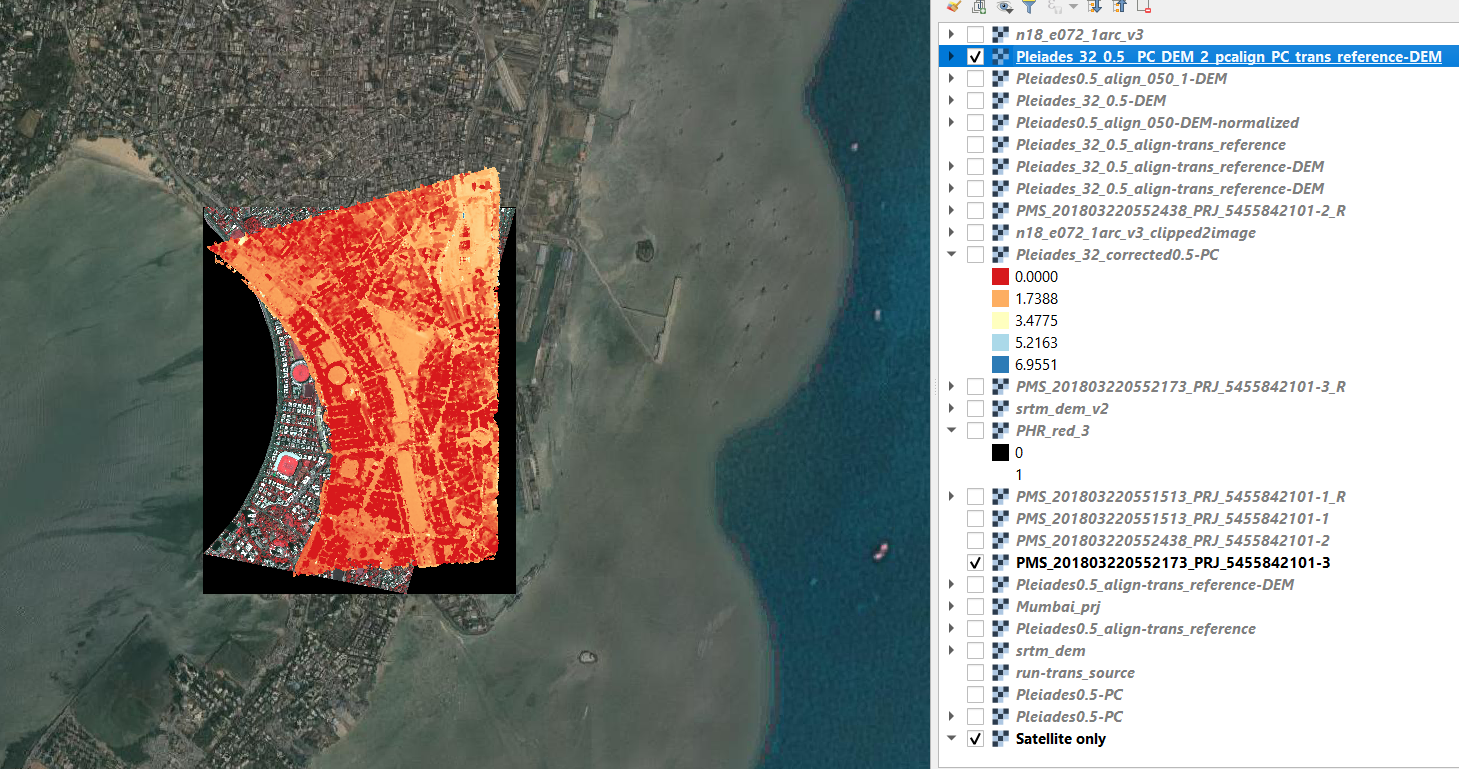
3. According to pc_align documentation <reference cloud> should be provided first and then <source cloud> but when i tried this way i am getting bad result. the output is a very small tif file with with only 4 pixels in it (i.e., after converting pc_align's out using point2dem tool). but surprisingly it works well with the reverse order i.e., <source cloud> first and then <reference cloud>, however the out is little off from the input's geolocation and also slightly a rotated version (Please find the image below). Aslo the elevation values are raging from negative to position with the significant amount of pixels covering the negative axis in the histogram (FYI: The dark orange color represent the negative values while the light orange is positive) even though there are no negative values in the reference srtm dem. So Tried --"rotation-order <string (default: xyz)>" i.e., --x-offset 270253 --y-offset 2096810 --z-offset 0 but still the results are even worse.
Also pls find my input shell script, stereo.default file and error-log below
Thanks & Regards
Sai Venkat Gajavelli |Data Scientist |GeoSpoc |www.geospoc.com| +91 9700085548 |

Scott McMichael
Nov 3, 2021, 10:35:04 AM11/3/21
to sai venkat, Ames Stereo Pipeline Support
The first thing you need to resolve is whether your input images are map projected. ASP can't run stereo with map projected images unless you have the exact DEM that was used to map project them, which is usually not available unless you created them yourself.
The ASP option to use a DEM to compute low-resolution disparity is rarely used and probably not what you want here. If both DEMs are reasonable then pc_align should be able to do a good job lining them up, you can try using --compute-translation-only to eliminate rotation as a potential problem. Start by plotting the two DEMs pre-alignment and see if they both look correct before you try to experiment with pc_align though. There are also options to incorporate a DEM during the bundle adjustment step but this is not needed in most cases.
Scott
--
You received this message because you are subscribed to the Google Groups "Ames Stereo Pipeline Support" group.
To unsubscribe from this group and stop receiving emails from it, send an email to ames-stereo-pipeline...@googlegroups.com.
To view this discussion on the web visit https://groups.google.com/d/msgid/ames-stereo-pipeline-support/274ffccf-1af9-4312-a548-49a7e081d3e6n%40googlegroups.com.

venkat sai
Nov 3, 2021, 11:01:03 AM11/3/21
to Scott McMichael, sai venkat, Ames Stereo Pipeline Support
Thanks a lot for the reply Mr.Scott. I Will try both ways DEM with bundle adjustment and also stereo after map projecting it with the reference dem. Here I am looking for help to correctly use reference DEM with stereo.
I am using map projected input but it's not created by me and hence it is not projected by using 30m farm den which I wanted to use as a low resolution dem to generate high resolution dem.
Thank you.
To view this discussion on the web visit https://groups.google.com/d/msgid/ames-stereo-pipeline-support/CAFVQiDTkd6RppZ1vqWB18ycHaJ%2BojWtExseF3PsW1WRQ9ieg5w%40mail.gmail.com.

Oleg Alexandrov
Nov 3, 2021, 11:39:24 AM11/3/21
to venkat sai, Scott McMichael, sai venkat, Ames Stereo Pipeline Support
ASP will not work with your projected inputs. You would need to get raw camera images. The reason is the following. ASP needs to do triangulation at the end, but then it needs to start from the cameras and project rays to the ground. If all you have is images which are already projected we cannot do that, unless we can undo that projection, which we cannot if we don't know how that projection was done.
Likely at this stage you don't need to do bundle adjustment yet. Likely you don't need to do alignment yet either, that is much later, after you already have a DEM that you are happy with.
If you are able to get raw camera images, you can start with our tutorial, at https://stereopipeline.readthedocs.io/en/latest/tutorial.html. Then one can read more about stereo algorithms, terrain creation, and mapprojection, here https://stereopipeline.readthedocs.io/en/latest/next_steps.html.
Let us know how it goes. Our doc is big and may indeed be confusing.
Oleg
To view this discussion on the web visit https://groups.google.com/d/msgid/ames-stereo-pipeline-support/CANDyy0DsJwQftT_ngSKuUt4JGO9%2BA-a9FADuz%3D-Xss_jgDYbNw%40mail.gmail.com.
Reply all
Reply to author
Forward
0 new messages