questions about subarea delineation or scenario simulation
98 views
Skip to first unread message

minfeng tang
May 13, 2021, 11:49:28 AM5/13/21
to EPIC / APEX Modeling Forum
Dear Luca,
I have some questions about subarea delineation and scenario simulation.
My study area is a subwatershed consisting about 61.9% cropland, 21.6% grassland/pasture, and 16.5% others. I want to know how different management practices affect grassland. There are several thoughts I have on evaluating this. However, I am not sure if any of these thoughts are appropriate associated with the application of APEX model.
The first thought is assuming the whole subwatershed is 100% grassland. My research interest is on grassland not on cropland. But here comes the questions:1) is it appropriate to make such as assumption ignoring the cropland? 2) if so, how to ignore the cropland in the application of the model? Just replacing the cropland area with grassland or eliminating cropland area and only focusing on the grassland?
The second thought is delineating the subwatershed into different subareas depending on different management practices on grazing. In this case, it might lead to numerous subareas due to the mixture nature of grassland and cropland within the subwatershed. How to model these subareas more effectively in WinAPEX with numerous subarea within a subwatershed.
Above are just some of my thoughts and any suggestions/comments are appreciated. Thank you!
Sincerely,
Minfeng

Luca
May 14, 2021, 11:49:18 AM5/14/21
to EPIC / APEX Modeling Forum
Dear Minfeng,
I think that the way you will move forward depends on the objective of your research. I understand that your interest is the grassland land use but, in my opinion, it is important to understand if the research focuses on the land use itself (for instance, the effect of different management on grassland) or on the effects on the watershed itself as it is (for instance, how the water yield and soil erosion on the entire watershed change when the grassland management change). If you are interested in the effect on the watershed, I would leave the cropland as it is now while changing the management on the cropland.
If you are interested in the effects on the entire watershed, I would do a simulation with the actual conditions (baseline) and then I would change the grassland management leaving the cropland management unaltered. In this way, you will be able to see the impact of the watershed of different grassland management scenarios. If you simulate the entire watershed as grassland, it might be unrealistic but, it can also be a scenario answering the question "what would happen if the entire watershed is converted to grassland"?
On the other hand, if you are interested in the impact of the management on the grassland, you can even use one subarea or you can do the simulation using EPIC instead of APEX.
For your second thought, how large is the area you are simulating? If it is very large with complex topography, you might consider using the ArcAPEX interface based on ArcGIS. This will make easy the delineation process but it might require quite a lot of work to get prepare the input data required by the GIS. If you want to use WinAPEX, I would suggest drawing on paper the configuration of the different subareas so you will have an idea of how they must be hydrologically connected. Then, you can assign the correct management to each of them.
Since this topic can be quite complicated, we can continue to discuss it here so, feel free to post your questions and we can move forward in designing your simulation.
Best,
Luca
minfeng tang
May 20, 2021, 11:04:46 AM5/20/21
to EPIC / APEX Modeling Forum
Dear Luca,
Thank you for your insightful suggestions. It took a while for me to go back to reconsider my study objective. I think at this stage, I am interested in the impact of the management on the grassland. I am considering using either EPIC or APEX with one subarea. Which one would you recommend? I know they are much alike, but it looks that differences do exist between these two models.
For the size of the study area, the EPIC manual says: the drainage area or HLU considered by EPIC is generally a field-size area, up to about 100 ha, where weather, soils, and management systems are assumed to be homogeneous. Can I use a study area that is a 1000 ha continuous tract of native range for simulation in EPIC?
Thank you!
Sincerely,
Minfeng
Luca
May 21, 2021, 10:59:20 AM5/21/21
to EPIC / APEX Modeling Forum
Dear Minfeng,
It is true that differences exist between EPIC and APEX but, they are very similar (in fact, many parts of the APEX code are identical to the EPIC code). Between the two, I prefer EPIC but I think it is only because it is what I used at the beginning of my adventure with simulation models. If I have to work with just one subarea, I would use EPIC but it is just a matter of personal preferences.
Now, because you are interested in the impact of the management on the grassland, the field size should not play a role. If all the conditions are kept constant, the impact is going to be the same on a 100 ha and 1000 ha field. The impact of the management can vary if different types of soils are present in the field you are simulating. If this is the case you can do a simulation with APEX creating a subarea for each soil type that is present in your study area. To keep things simple (and if you are not interested in the impact at the watershed level) you can even keep each subarea as an extreme without hydrologically connect them.
Let me know if this helps or if you need more information.
Best,
Luca

Carlos Alberto Arnillas
May 21, 2021, 11:04:12 AM5/21/21
to EPIC / APEX Modeling Forum
Hi Luca, Mingfeng
sorry for jumping into your discussion. Luca, you mentioned that you would prefer EPIC over APEX, does it mean that both models are being updated simultaneously?
Carlos Alberto
Luca
May 21, 2021, 11:26:15 AM5/21/21
to EPIC / APEX Modeling Forum
Yes, we try to keep both of them updated. Usually, a new development is first developed and tested in EPIC (to avoid the complication introduced with the routing we have in APEX) and then it is "exported" to APEX.
Luca
Carlos Alberto Arnillas
May 21, 2021, 11:32:46 AM5/21/21
to EPIC / APEX Modeling Forum
And do they both use similar input files and documentation?
in other words, what we learn from using one can be translated to the other one?
Luca
May 24, 2021, 9:14:44 AM5/24/21
to EPIC / APEX Modeling Forum
Yes, most of the input files are compatible between EPIC and APEX (for example, the management file, the daily and monthly weather files, the tables with the crop, fertilizer, tillage, and pesticide information). Some input files are not compatible such as the parameter table (PARM***.DAT, control table). Then, the subarea file is unique to APEX.
Hope this helps,
Luca
minfeng tang
May 24, 2021, 11:37:23 PM5/24/21
to EPIC / APEX Modeling Forum
Dear Luca,
I will keep using APEX then as it might allows me to simulate different management practices within the same study area. I was not able to fully understand this statement: To keep things simple (and if you are not interested in the impact at the watershed level) you can even keep each subarea as an extreme without hydrologically connect them. According to the WinAPEX Users guide, it looks like that some primary variables must be specified to determine the subarea including management, watershed area (WSA), longest distance from outlet (CHL), and routing reach length (RCHL). So say, if I want to study and compare two subareas, which are delineated solely by different management due to soil type differences, how can I enter those variables in the WinAPEX interface? Can I use assumed value for WSA, CHL, and RCHL? In real situations, will I have the issue that I essentially do not have these variables to fill the blanks in WinAPEX interface to delineate the subareas as these subareas are delineated by "subjectivity" instead of hydrological conditions? I mean soil types or management practices could always be determined as different (depending on thresholds) as long as the research objective needs.
Another question is about the herdfile.dat. I looked through the sample data in APEX file and didn't see a herd data that is as complete as the the figure 2.32 shows (p166, The APEX1501 user manual). It looks like the sample data ignores grazing. In the Texas Central database, a data file named Owner has the corresponding variables explained in the manual (p164, The APEX1501 user manual). Are the sample data set in APEX package independent from the Central Texas database in WinAPEX package? If we want to customize our own model, which one do we need to modify?
I apologize if my questions are not stated clearly. I feel I still got many questions while reading these manuals and trying to apply those in my own research. Thank you for your help.
Sincerely,
Minfeng
Luca
May 25, 2021, 10:12:44 AM5/25/21
to EPIC / APEX Modeling Forum
Dear Minfeng,
you are right, WSA, CHL, and RCHL are required by the model in order to work. You can assume these values since you are not using real landscape and site conditions to delineate the field. What I would do is to assume that the shape of the field I am simulating is a square (you can decide the area of the field which will be the WSA) and then I would calculate the CHL and RCHL according to the size of the field following the scheme I have attached here. When creating the different subareas in WinAPEX, the interface will ask where the water will flow and this information will be used to hydrologically connect the subareas.
I am not sure I am fully understanding the second question. I am not sure how the sample data was cerated but definitely, it is different from what you see in the user manual. Figure 2.32 shows a herd file with several owners and herds but this is not always the case since you can use the model without simulating grazing operation. Where do you see the file named Owner? Is it in the database or is it an actual text file?
Best,
Luca
minfeng tang
May 25, 2021, 11:11:23 AM5/25/21
to EPIC / APEX Modeling Forum
Dear Luca,
Now I kind of understanding your statement: To keep things simple (and if you are not interested in the impact at the watershed level) you can even keep each subarea as an extreme without hydrologically connect them. I can define the subareas using the assumed values for WSA, CHL, and RCHL using the method you mentioned. I can even assume these two subareas as two extreme subareas (as the left graph shows), and they are not hydrologically connected. The graphs are vey helpful.
The file named Owner is in the Central Texas database not an actual text file. So when I edit the database through interface in WinAPEX, does that change reflect in the actual text files in APEX? Or. they are essentially independent. When I am doing my project, I just need to modify the database if using WinAPEX? Thank you!
Sincrely,
Minfeng
Luca
May 26, 2021, 9:50:33 AM5/26/21
to EPIC / APEX Modeling Forum
Minfeng,
When you edit or create something with the WinAPEX interface, it is applied to the database only. This is the chain of events when the user edits something using the WinAPEX interface and then runs the model. For this example let's say the user wants to change the amount of fertilizer applied in a management. The user selects the management using the WinAPEX interface and applies the modification. The interface will write this modification in the Access database. When the user runs the model, the interface reads the database and creates all the text files required by the model to run. At the end of the simulation, the interface reads the output files and writes the values in the output Access database (this is a separate database).
Let me know if you need more information.
Luca
minfeng tang
Jun 3, 2021, 12:00:18 PM6/3/21
to EPIC / APEX Modeling Forum
Dear Luca,
Thanks the detailed explanation. Now I have processing weather data using weather import and had some issues. When I wanted to find out the latitude and longitude of the new weather station, I used the function that was designed in weather import. Somehow I feel that function might now work, and I actually found thee information from somewhere else already. It looks like that function led me to a page where there is no way to turn it off and go back to the home page of the app. I had to close the app and re-started it. It then repeatedly showed that this app is being used (pic attached) whenever I restated it. I am not sure if this issued had happed in rare instances or quite often. Thank you.
Sincerely,
Minfeng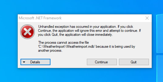
minfeng tang
Jun 3, 2021, 12:07:09 PM6/3/21
to EPIC / APEX Modeling Forum
It turned out that weather import app could not be turned off just by clicking exit. I finally solved this issue by running task manager and clicking end task and turned it off and then restart. It worked. Just give some information for those who might have such issue in the future. Thanks.
Sincerely,
MInfeng
minfeng tang
Jun 3, 2021, 12:34:09 PM6/3/21
to EPIC / APEX Modeling Forum
Dear Luca,
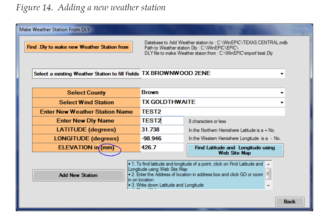
Is the unit for elevation in weather import mm (millimeter) or m (meter)? Just want to confirm that the unit is correct based on the example in the manual (page 16, Creating a WinEPIC/CropMan WinAPEX Database and Related....). Thanks.
Sincerely,
Minfeng
Luca
Jun 4, 2021, 10:41:47 AM6/4/21
to EPIC / APEX Modeling Forum
The elevation of the weather station must be entered in meters as indicated in the manual on how to create a database and not millimeters as indicated in the interface. I will see if we can fix the error in the interface.
Thanks for reporting this problem.
Regards,
Luca
minfeng tang
Jun 4, 2021, 11:09:17 AM6/4/21
to EPIC / APEX Modeling Forum
Thanks for letting me know.
Sincerely,
Minfeng
Reply all
Reply to author
Forward
0 new messages