TODAY'S FUN LINKS: |  | The Weather Channel - March 26, 2022 Earlier this week, on World Meteorological Day (March 23), we spoke to Dr Rajeevan to learn more about his experience as a renowned meteorologist and scientist in India. |
|
|
|---|
|
| | Earth Island Journal - March 28, 2022 In the past decade, two interactive maps have changed the way we see the weather. |
|
|
|---|
|
| | NOAA - March 28, 2022 Launching the first ever national rip current forecast model, creating high-resolution sea ice information to improve navigation, and using artificial intelligence to process marine mammal calls: These are just a few of NOAA’s many notable scientific accomplishments from the past year. |
|
|
|---|
|
| | USA Today - March 24, 2022 Satellite images taken before and after a tornado struck the Arabi area of New Orleans show the extensive damage. |
|
|
|---|
|
| | Forbes - March 24, 2022 A recent tornado in Texas highlights how far this lifesaving technology has come in just a few years. |
|
|
|---|
|
| | CBS 42 - March 25, 2022 What do “the Ed Sullivan Show,” “I Love Lucy,” and early 20th-century weather reports have in common? Censorship. |
|
|
|---|
|
| | ScienceDaily - March 28, 2022 Researchers have used computer simulations to show that weather phenomena such as sudden downpours could potentially be modified by making small adjustments to certain variables in the weather system. |
|
|
|---|
|
| | The Washington Post - March 18, 2022 Scientists were shocked this month when a research station in Antarctica reported extraordinarily warm weather. The temperature at Concordia Research station atop Dome C on the Antarctic Plateau – typically known as the coldest place on Earth – surged to an astounding 11.3 degrees Fahrenheit (minus-11.5 Celsius) on March 18. |
|
|
|---|
|
|
|
|
|
WEATHER HAZARDS (During The Next 24 Hours)
SEVERE WEATHER OUTLOOK
(potential for tornadoes, damaging winds, and large hail within the next 24 hours)
ISOLATED Severe Thunderstorms
(Microbursts, Large Hail, Isolated Tornadoes)
Lower CO, NM Front Range
Some Thunderstorms May APPROACH Severe Limits
S FL
HEAVY RAINFALL OUTLOOK
(potential for an inch or more total rainfall within the next 24 hours)
Isolated Locations In
S FL
(QPF 1-2")
Isolated Locations In
SW BC....W WA
(QPF 1-2")
WINTER WEATHER POTENTIAL
(potential for Moderate Icing, Snow 2 - 4" or more, and/or temperatures below 10 deg F)
Isolated Locations In
RI....CT....NY....NE PA....N NJ
(Snow, Mostly Mixed Or Rain NYC, LI; 3 - 6")
Scattered Locations In
WA Olympic Peninsula....BC....AB Rocky Mountains
Snow: Above 4000 Feet; 4 - 16")
Isolated Locations In
SW ND....W, N SD....IA....S MN
(Wet Snow; Rain, Sleet May Mix In; 2 - 4")
Isolated Locations In
NL (Labrador And NW Newfoundland)
(Snow; 4 - 12")
(a review of important weather features around the world)
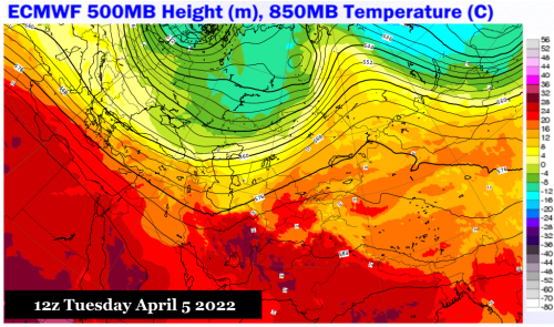
IODC
ECMWF, METEOBLUE, EUMETSAT
A warmer, and much stormier, prognosis for the Levant and Persia.
The retreat of the coldest air toward Arctic Siberia continues apace. and chances for important deliveries of harsh chill are just about finished for the spring. But there are still high-impact disturbances embedded within the polar westerlies, and at least two of these will make a mark on the Middle East, Iran and the Central Asian Republics over the course of the next ten days. What makes these impulses troublesome is that there will be inflow from the famed "Out Of Africa" moisture fetch. Higher dewpoints are building in the Nile Headwaters, and you can see the approach of a stronger southwest flow from across the Sahara Desert. This moist flow will interact with the warming atmosphere from Mesopotamia into Pakistan to produce bouts of severe weather and torrential rains.
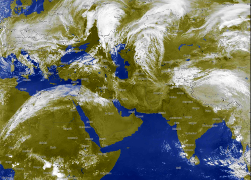
HIMAWARI 8
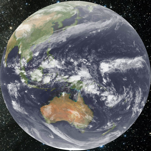
Kochi University
There is a linkage between tropical forcing associated with the Madden-Julian Oscillation (Indonesia into the middle equatorial Pacific Basin) and the polar westerlies (Vietnam to the Aleutian Islands). But the orientation of the connection is such that amplification of the 500MB flow over and about North America will be marginal, with ridges and troughs not having any anchoring in the Arctic Circle. The main influences in apparent weather will be in the tropics, with some potential for warm-core cyclogenesis in the Marianas Chain and the Philippines. Heavy rainfall and thunderstorms are an ongoing threat over the Maritime Continent, but Australia will be relatively mild and mostly dry.
GOES WEST
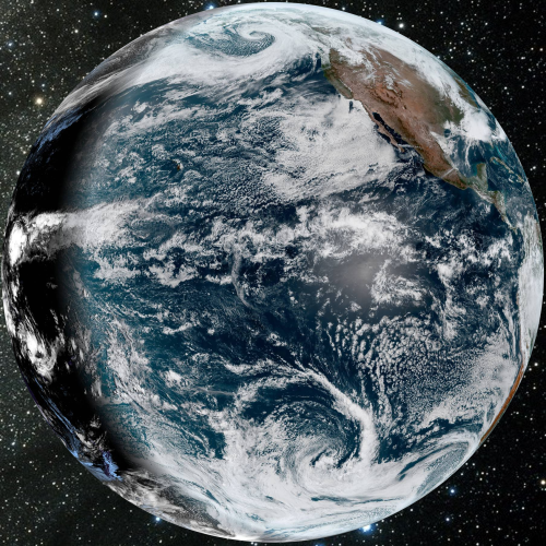
NOAA/NESDIS
The numerical models are having a difficult time figuring out the interplay between the impressive subtropical jet stream (just off of Baja California coastline) and a very intense Gulf of Alaska vortex. These two features will soon shift inland, with the southern branch, rich in moisture, setting up a severe weather threat along the southern and eastern tiers of the U.S., and the northern stream component bringing a colder change to the Intermountain Region and Prairie Provinces by late in the new week.
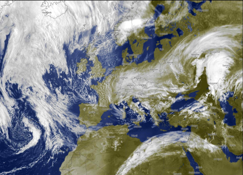
GOES EAST

NOAA/NESDIS
Cold air did sweep down again through the Northeast. But milder air and an upper disturbance over the Great Plains, Texas and Dixie will progress to the Atlantic shoreline by midweek. Another impulse in the Southwest poses a threat for intense thunderstorms in the High Plains Sunday, and later into Texas and Oklahoma.
Note the broad tropical wave over the western Amazon Basin and Upper Andes Chain. This system may be the last in a series of intense convection groups that started life off of the coast of Brazil and worked westward. Cold fronts continue to make progress across Chile and Argentina, with the strongest convective threats above the Rio De La Plata system.
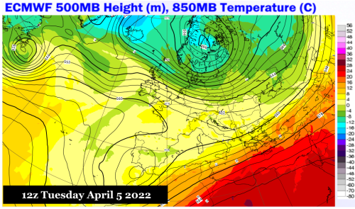
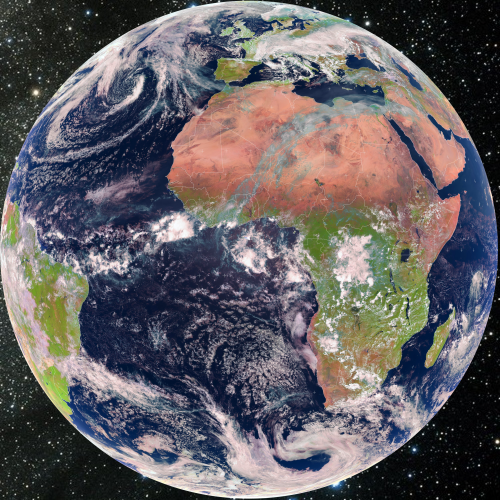
METEOSAT
ECMWF, METEOBLUE, EUMETSAT
It is still cold enough to snow in parts of central Europe. But the vast 500MB cold pool in Germany and Austria will tend to break in two, with a southern system in the Iberian Peninsula and a vortex retreating through Scandinavia into northern Russia.
Pay close attention to the satellite view over northern Africa, where a vigorous jet stream branch is bringing linear shower and thunderstorm activity eastward, setting up a moisture fetch and increasing rainfall potential in the Levant in about five to seven days.
There are impressive ITCZ thunderstorm groups, especially in the Congo Basin. Convection is also affecting an area from South Africa into Mozambique.

.png?cb=969458)

.png?cb=372003)
.png?cb=159259)
.png?cb=850977)
.png?cb=853952)
.png?cb=253979)
.png?cb=339673)