TODAY'S FUN LINKS: |  | The Conversation - 7 April 2023 New BAMS research is the first formal scientific investigation that proves global warming is helping fuel baseball’s recent home run spree. |
|
|
|---|
|
| | Mike Brennan Selected as Director of NOAA’s National Hurricane Center NOAA - 10 April 2023 As branch chief of the Hurricane Specialist Unit since 2018, Brennan supervised one of NOAA’s highest-profile operational forecast units through 18 U.S. landfalling hurricanes and more than 20 U.S. tropical storm landfalls. He now fills the vacancy left by the new director of NWS, Ken Graham. |
|
|
|---|
|
| | Yale Climate Connections - 3 April 2023 The fourth-deadliest U.S. hurricane of the past 60 years attained category 5 status with 160-mph sustained winds and a central pressure of 937 mb for a few hours before weakening slightly and hitting Florida as a category 4. |
|
|
|---|
|
| | Weather Underground - 31 March 2023While all tornadoes are capable of damage, meteorologists use the term "violent tornadoes" to refer to those rated EF4 or EF5, the highest two ratings on the Enhanced-Fujita scale. |
|
|
|---|
|
| | Sandia National Laboratories - 6 April 2023 The model simulates critical aspects of Earth’s climate system that might impact conditions in the United States in the coming decades. |
|
|
|---|
|
| | (may require subscription) E&E News - 7 April 2023 America's favorite pastime will need to adapt as major league cities face more extreme weather in a changing climate. |
|
|
|---|
|
|
WEATHER HAZARDS (During The Next 24 Hours)
SEVERE WEATHER OUTLOOK
(potential for tornadoes, damaging winds, and large hail within the next 24 hours)
ISOLATED Severe Thunderstorms
(Microbursts, Large Hail, Isolated Tornadoes)
FL....AL....GA....E TN....C, E KY....IN....OH....W PA....WV....W MD....W MD....W, C NC....SC
HEAVY RAINFALL OUTLOOK
(potential for an inch or more total rainfall within the next 24 hours)
Scattered Locations In
C, S ON....MI....N OH....N IN....N IL
(QPF 1 - 3")
Scattered Locations In
Coastal BC, WA, OR
(QPF 1 - 3")
WINTER WEATHER POTENTIAL
(potential for Moderate Icing, Snow 2 - 4" or more, and/or temperatures below 10 deg F)
Scattered Locations In
W ON....MN....W WI
(Wet Snow; 4- 10")
Scattered Locations In
BC....W WA....W OR
Wet Snow; 4 - 24"; Above 5000 Feet)
(a review of important weather features around the world)
IODC
ECMWF; METEOBLUE; EUMETSAT
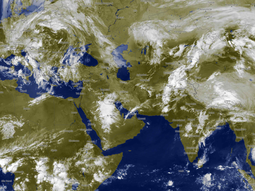
The transition from thunderstorm threats to high heat and dryness is a slow one.
This being a building El Nino episode, what starts out as a stormy/humid spring in the Middle East and Persia is bound to turn very sunny, hot and dry. Most likely the transition will be complete by the second week of May. For now, however, the lingering cold trough complex across eastern Europe continues to eject shortwaves at 500MB that create opportunities for rain and thunderstorms from Anatila and the Levant across the western half of Iran. You will note that on the synoptic charts that some intense heat is building across parts of North Africa, Saudi Arabia and India. The cores of the subtropical highs are already visible. Risks for severe weather and flooding will be ongoing, and may be more widespread across southwestern Asia in the last week of April.
HIMAWARI 8
Kochi University
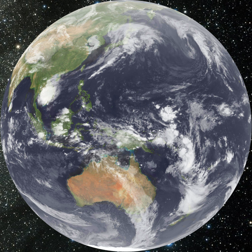
At the same time as a tropical cyclone may be forming over Oceania, strong cold fronts are developing over the southern Indian Ocean and progressing through Australia into New Zealand. This set-up, which employs both deep tropical moisture from the dying Madden-Julian Oscillation pulse across Indonesia and the equatorial Pacific Ocean. The polar westerlies have strong disturbances (see off of eastern Asia shoreline), but less connection to the MJO. Cold air is less and less of a factor as we move into the middle of Spring across the Northern Hemisphere.
GOES WEST
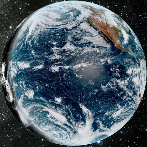
NOAA/NESDIS
Perhaps a perfect title for this GOES WEST image might be "this is a classic Gulf Of Alaska Low". The gyre has input from the subtropical jet stream, and helps to flatten the mean 500MB flow across North America. So while impulses will eject out of the sprawling 500MB low, amplification will not be severe and drainage of colder air will be minimal. Now that cAk regimes are nonexistent or staying above the Arctic Circle, opportunities for meaningful drops in temperature will be limited.
GOES EAST

NOAA/NESDIS
The storm track sequence over North America has reactivated. The first impulse in the series is over the western Atlantic Ocean. The second and stronger disturbance, with activating frontal structure, is emerging from the Great Plains. This next feature will set off an array of severe thunderstorms, followed by a brief cooler trend. The last major snowfall in populated North America will affect the north central states and Ontario through Sunday night.
Cold frontal passages are ramping up across the southern half of South America. Much colder air through the southern Pacific Ocean will impact Chile and Argentina into southern Brazil. The hot and humid values over the Amazon Basin and Caribbean shoreline continue to exhibit diurnal thunderstorm production.
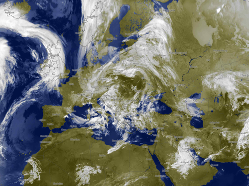
METEOSAT
ECMWF; METEOBLUE; EUMETSAT
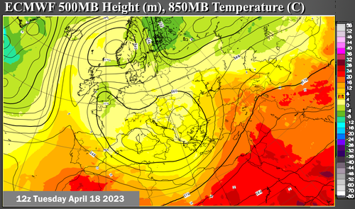
Many official projections of last winter had a blocking signature over far northern Europe, which would set up a colder infiltration and increased snow chances across the British Isles and much of the subcontinent. That never happened, but lo and behold that very alignment is setting up now! The deep closed 500MB low continues in play over the Danube Valley and Balkan Peninsula. Temperatures are cool, but not cold, and widespread stratiform rain within the cold sectorm is balanced by the ongoing threat of intense thunderstorms over Italy and Greece, and likely soon over Asia Minor.
The Saharan heat ridge is trying to organize through northern Africa. The eastern boundary of the anticyclone is across the Arabian Peninsula (thunderstorms), while the ITC is fairly well-developed in the equatorial regions with widespread, mostly diurnal, convection. A small tropical system remains in Mozambique.