WEATHERAmerica Newsletter, Saturday, June 3, 2023 at 11:15 P.M. CT; Weather Extremes And Global Satellite Imagery
30 views
Skip to first unread message

Larry Cosgrove
Jun 4, 2023, 12:17:24 AM6/4/23
to weather...@googlegroups.com
TODAY'S FUN LINKS:
WEATHER HAZARDS (During The Next 24 Hours)
SEVERE WEATHER OUTLOOK
(potential for tornadoes, damaging winds, and large hail within the next 24 hours)
(potential for tornadoes, damaging winds, and large hail within the next 24 hours)
ISOLATED Severe Thunderstorms
(Microbursts, Large Hail, Isolated Tornadoes)
NE AB....N, C SK....MB....W ON....NW QC
NE AB....N, C SK....MB....W ON....NW QC
Some Thunderstorms May APPROACH Severe Limits
W LA....TX....W, C OK....W, C KS....NB....SD....WY....CO....NM....N, C AZ....UT....ID....SW MT
Some Thunderstorms May APPROACH Severe Limits
FL
Some Thunderstorms May APPROACH Severe Limits
W MD....E WV....W VA....E KY....TN....NW GA....N AL
Some Thunderstorms May APPROACH Severe Limits
CA High Sierra
HEAVY RAINFALL OUTLOOK
(potential for an inch or more total rainfall within the next 24 hours)
(potential for an inch or more total rainfall within the next 24 hours)
Isolated Locations In
Coastal ME....NS
(QPF 1 - 3")
Isolated Locations In
W LA....TX....W, C OK....W, C KS....NB....SD....WY....CO....NM....N, C AZ....UT....ID....SW MT
(QPF 1 - 3")
Isolated Locations In
N BC
(QPF 1 - 3"; Higher Elevation Heavy Snows)
EXCESSIVE HEAT RISK
(Potential For Temperature To Exceed 95 deg F)
Isolated Locations In
C, E CA....NV....AZ....UT....W CO....W, C NM....W TX
Isolated Locations In
ND....E SK
GLOBAL WEATHER SUMMARY
(a review of important weather features around the world)
IODC
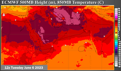

ECMWF; METEOBLUE; EUMETSAT
Insult To Injury? Extreme Heat In The Middle East And Persia With Threat Of Arabian Sea Cyclone!
The heat ridge complex has been a given across the Levant, Iran, and India for the past six years running. So it comes as no surprise that with a European trough complex pumping up 500MB heights from northern Africa into Central Asia, brutally hot and dry weather will settle into a wide stretch of territory and stick around for a while. But notice the convective groupings to the west of the Indian subcontinent. The new, upgraded version of the ECMWF series is forecasting a major tropical cyclone formation to form to the left of Goa. This system, if it verifies, would crawl beneath the big subtropical high and could threaten either the eastern Arabian Peninsula or the portion of Iran nearest to the Strait of Hormuz. Strike time, if any, is probably not until the middle of June. In the meantime, we may see readings surpass 50 deg C in parts of southwestern Asia and in the Indian states below the Himalaya.
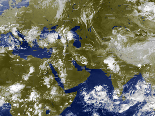
HIMAWARI 8
METEOBLUE; Kochi University
The demise of Typhoon Mawar is now complete, having merged with a broad, cold upper low below the Aleutian Islands. This combinant feature will likely be a vortex for a few days, and help to rebuild the ridge complex now over the Prairie Provinces. The ITCZ is incoherent, but could spin up another tropical cyclone soon with threats to the Marianas and the Philippines. It is also possible that a new storm could develop across the Bay of Bengal, with impacts to Myanmar and Thailand.
Curiously, despite the very obvious El Nino development along the equatorial regions, colder air and storms are starting to impact Australia and New Zealand. Typically, in a formative +ENSO environment, warmth and drought will escalate across the Maritime Continent (which includes that nation). But a broad trough complex, and convective area, involves much of the subcontinent, and keeps moisture potential going. At least for now.
GOES WEST

NOAA/NESDIS
The elongated and dirty ridge complex covering the western half of North America is still resilient enough to prevent penetration of disturbances and impulses in the eastern Pacific Basin into the U.S. and Canada. Some energy west of California will undercut the ridging, however, increasing threats for thunderstorms over the Desert and Intermountain Region, eventually reaching the Great Plains and Texas. For those living along and to the right of the ridge axis, dry and warm conditions may give way to cool intrusions pushing through the Prairie Provinces.
GOES EAST

NOAA/NESDIS
The outline of a vast, but relatively weak, trough is shown across the eastern half of North America. Shortwaves from the Arctic Regions modify as they slowly fill the trough complex. This pattern occasionally reduces temperatures and triggers thunderstorms, though not as persistent and strong as the convection occurring west of the Mississippi Valley.
Cold frontal passages are stronger across Chile and Argentina. Dry but very warm air controls the central third of South America, while tropical impulses are setting off diurnal convection across the eastern Amazon Basin.
METEOSAT
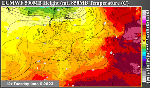
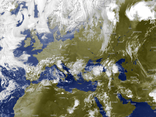

ECMWF; METEOBLUE; EUMETSAT
An El Nino episode often increases the longevity of a Mediterranean climate, as is evidenced by the pattern shown by the ECMWF series through June 13. The concentration of energy and cool air across the central and southern portion of the subcontinent triggers precipitation and prevents hot weather. Most numerical model projections show a closed 500MB low forming over the Balkan Peninsula and Danube Valley, which will increase thunderstorm threats in Asia Minor while intensifying the heat ridge complex across the Middle East and Iran.
The ITCZ is struggling to maintain a presence across equatorial Africa. Sandwiched between two very dry and hot air masses to its north and south, impulses do not survive after diurnal lifting. The only truly colder air is across the coastline of South Africa.
Reply all
Reply to author
Forward
0 new messages