TODAY'S FUN LINKS: |  | The Providence Journal - April 7, 2022 Part of the Weather Service's Skywarn program, storm spotters help form the nation's "first line of defense against hazardous weather," the Weather Service says. Each year, the Weather Service recruits more storm spotters, and it's offering another free training program starting next week. |
|
|
|---|
|
| | Popular Science - April 8, 2022 Camaliot allows your phone to crowd source weather data that could help predict rainfall and cosmic events like solar flares. |
|
|
|---|
|
| | USA Today - April 11, 2022 A wild week of weather is on tap for parts of the northern and central USA, including softball-sized hail and a tornado that has already touched down Monday in Arkansas. |
|
|
|---|
|
| | Forbes - April 8, 2022 The U.S. tornado season, which typically runs from March until June, is already off to an active start, particularly with some long and dangerous storms happening outside of “Tornado Alley.” |
|
|
|---|
|
| | Phys.org -April 7, 2022 An international team of researchers has found evidence of a megathrust earthquake occurring approximately 3,800 years ago off the coast of what is now Chile. |
|
|
|---|
|
| | NASA Earth Observatory - April 9, 2022 A high-pressure region combined with a passing frontal system off the South African coast to create an eye-catching gap in the clouds. |
|
|
|---|
|
| | Axios - April 6, 2022 Just as the spring tornado season kicks into high gear, the National Weather Service is facing shortages in key gases it uses to fill weather balloons. |
|
|
|---|
|
| | The New York Times - April 7, 2022 Hurricanes and winter weather, such as snow, ice storms and blizzards, were the most common events cited, according to a Gallup poll. |
|
|
|---|
|
|
WEATHER HAZARDS (During The Next 24 Hours)
SEVERE WEATHER OUTLOOK
(potential for tornadoes, damaging winds, and large hail within the next 24 hours)
STRONG WINDS
(Pressure Gradient Derived)
NS....NB....PE....Extreme E QC....S Labrador
ISOLATED Severe Thunderstorms
(Microbursts, Large Hail, Isolated Tornadoes)
Coastal, E TX....LA....MS....AL....GA....FL
HEAVY RAINFALL OUTLOOK
(potential for an inch or more total rainfall within the next 24 hours)
Scattered Locations In
Coastal, E TX....LA....MS....AL....GA....FL
(QPF 1 - 4")
WINTER WEATHER POTENTIAL
(potential for Moderate Icing, Snow 2 - 4" or more, and/or temperatures below 10 deg F)
Isolated Locations In
E MT....ND....N MN....Far W ON....S MB
(Wet Snow; 2 - 4")
Isolated Locations In
QC....S Labrador
(Wet Snow; 4 - 8")
GLOBAL WEATHER SUMMARY
(a review of important weather features around the world)
IODC
ECMWF, METEOBLUE, EUMETSAT
The thunderstorm threats are keeping the heat from advancing northward. But given some time, the disturbances and jet stream wukk head north. And the heat ridge complex will return to prominence.
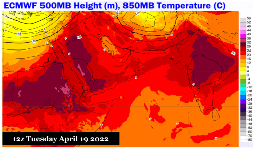
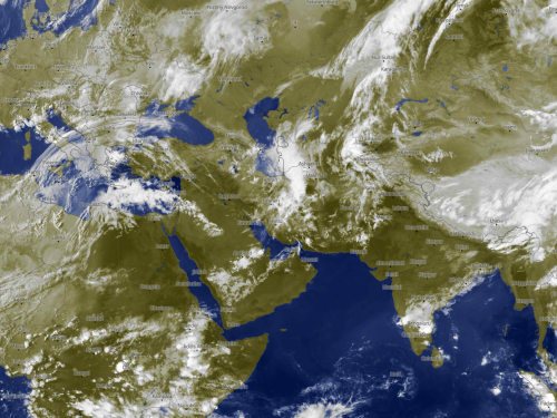
In a pattern that has been repeated every late winter and spring for the past five years, there is a transition period between cold intrusions from Europe or Siberia and hot weather connected with the rise of the Persian/Saharan subtropical high. That "back and forth" is in play now, and should continue through the end of the month. You can see shortwaves on regional satellite images, which originate within the polar westerlies and pass through Asia Minor, the Caucasus, and the Central Asian Republics. As long as the core of the impulses stays close to the Levant and Persia, thunderstorms will fire along the surface thermal boundary that usually runs from Egypt into the Strait of Hormuz, then on through Pakistan and northern India. That convection suppresses the striations of hot air that move from Africa into the Arabian Peninsula, then on into the Indian subcontinent. When a moisture fetch is established from the Nile Headwaters into Saudi Arabia and Iran, excessive rainfall and severe weather may occur in much of the Middle East through the Indus River watershed. This is a rough patch in weather, but more than likely May will see more sunshine, and unbearably hot temperatures.
HIMAWARI 8
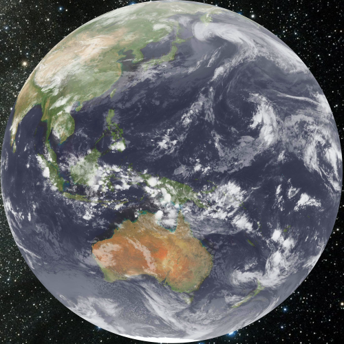
Kochi University
The Madden-Julian Oscillation weakens. And with it falling apart will come an end to the northern Pacific Basin storm sequence. The MJO signal has been quite impressive, built around a Kelvin wave that migrated from the equatorial Indian Ocean. But the impulse has fragmented, with convective remnants along and below the Equator over Indonesia and northern Australia. Most of the energy has transferred to the trough and storm complex along and to the right of the International Dateline, which will soon congeal due to an impression of the former Typhoon Malakas. But the cold air parcels in Asia will soon have little impact further east, and the risks for moisture being derived into the Australian frontal structures will return. Much of the Maritime Continent will have a run of very hot temperatures with reduced precipitation.
GOES WEST
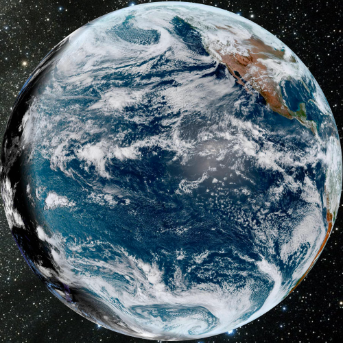
NOAA/NESDIS
It took all winter and early spring t0o see consecutive cold intrusions and rising precipitation chances, but the West Coast of North America is awaiting the passage of two very strong troughs and embedded storms. The first will arrive in about five days, and another in about a week or so. The Desert and Intermountain Region will be subject to colder air, heavy high elevation snows, and strong/severe thunderstorms off and on until the start of May, when ridging will return out of northern Mexico. The first system in the series, meanwhile, has three separate jet streams attached and plenty of available moisture from the equatorial Pacific Ocean.
GOES EAST
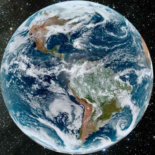
NOAA/NESDIS
The giant storm that hit the Midwest and Great Plains is now over Quebec, and will likely reorganize further east with cold advection across the Great Lakes and Northeast. But the influence of this large cyclone is fairly limited, owing to the lateness of the season. Additional energy is building over NM and W TX, and will soon activate frontal wave cyclogenesis over the Lone Star State by Sunday morning. I am expecting a severe weather event along the Interstate 10 and 20 corridor on April 17, with the resultant surface low turning up along the Atlantic shoreline as a sort of Nor'easter on Monday.
There is a dramatic difference of weather across the northern half of South America (diurnal convection and hot/humid weather) and Chile/Argentina. Already there are strong cold fronts and cold upper lows arriving from the Pacific Ocean, which will mean important drops in temperature for the southern reaches of the continent.
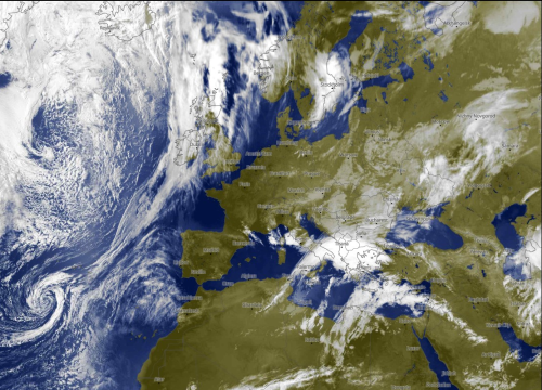
METEOSAT
ECMWF, METEOBLUE, EUMETSAT
This is no way to start spring.
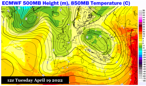
A blocking signature is taking shape over Scandinavia, which in turn will force the elongated trough and frontal structure over the eastern Atlantic Ocean into Europe, and help to form two closed 500MB lows. The first cools down the British Isles and France; the second and larger feature will mean very chilly weather over the eastern portion of the subcontinent, and chances for off-season snowfall in mountainous areas.
Note the blow-up, once again, of thunderstorms across South Africa into Mozambique, tied to a stagnant upper disturbance that has entrained moisture from the western Indian Ocean and the ITCZ. See also the lone tropical wave over Niger, which will migrate westward and fall apart in a sheared and dry environment.

.png?cb=217788)
.png?cb=401815)
.png?cb=222282)
.png?cb=903106)
.png?cb=799542)
.png?cb=312857)
.png?cb=51202)
.png?cb=56991)