TODAY'S FUN LINKS: |  | The Weather Channel - April 3, 2022 A team of scientists at NASA has for the first time ever spotted regional fluctuations in atmospheric carbon dioxide (CO2) across the globe due to emissions from human activities during the COVID-19 pandemic. |
|
|
|---|
|
| | Phys.org - April 5, 2022 Large quantities of plastic—transported by rivers, the air and shipping–can now be found in the Arctic Ocean. High concentrations of microplastic can be found in the water, on the seafloor, remote beaches, in rivers, and even in ice and snow. |
|
|
|---|
|
| | FOX 10 - April 1, 2022 Each year jokers around the world get the day of April 1 to play tricks on unsuspecting victims, but as the flowers are blooming and air masses clash, Mother Nature never seems to take a day off to play pranks on the unsuspecting. |
|
|
|---|
|
| | UN News - April 1, 2022 Antarctica, the world’s coldest, windiest and driest continent, has often been referred to as a stable ‘sleeping giant’, but increasingly extreme temperatures, together with unusual rain and ice shelf shifts, remind us that it must not be taken for granted, the UN Weather Agency (WMO) warned on Friday. |
|
|
|---|
|
| | OUDaily - March 29, 2022 While presenting a weather report for OU Nightly, an OU meteorology and broadcast senior Mikayla Smith utilized American Sign Language for deaf and hard-of-hearing communities who have been “drastically underserved” in broadcast media. |
|
|
|---|
|
| | Boston.com - April 5, 2022 “If there’s a meteorologist out there who doesn’t feel comfortable talking about climate science, they’re missing the boat.” |
|
|
|---|
|
| | Eos - April 5, 2022 The World Meteorological Organization verifies and documents record-setting temperatures, winds, lightning, and more, offering snapshots of Earth’s extremes and hints about its changing climate. |
|
|
|---|
|
| | The Washington Post - April 4, 2022 The National Weather Service says the scrubbed launches won’t affect forecasts, but some meteorologists disagree. |
|
|
|---|
|
|
WEATHER HAZARDS (During The Next 24 Hours)
SEVERE WEATHER OUTLOOK
(potential for tornadoes, damaging winds, and large hail within the next 24 hours)
Some Thunderstorms May APPROACH Severe Limits
C, E TX
HEAVY RAINFALL OUTLOOK
(potential for an inch or more total rainfall within the next 24 hours)
Scattered Locations In
Newfoundland
(QPF 1 - 3")
WINTER WEATHER POTENTIAL
(potential for Moderate Icing, Snow 2 - 4" or more, and/or temperatures below 10 deg F)
Isolated Locations In
BC....WA....OR....ID....MT....N WY....SD....SE ND....NW MN....Far W ON
(Snow, Sleet; Mostly Nocturnal, Above 4000 Feet; 3 - 9")
Isolated Locations In
NE AB....N SK....N MB
(Snow; With Intense Chills; 4 - 12")
(a review of important weather features around the world)
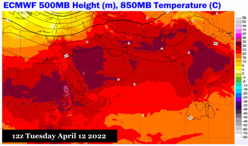
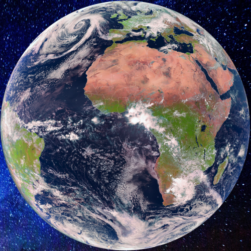
IODC
ECMWF; METEOBLUE; EUMETSAT
Still quite stormy. But the heat ridges are slowly advancing northward.
I counted three viable 500MB shortwaves tracking through the Middle East and Persia between now and April 19. While the cold pools are slowly weakening, the integrity of the impulses is still well-defined, with abundant energy present. You can also detect some capture of deep tropical moisture from the Nile Headwaters, which will be a factor before the jet stream shifts further north in the first of May. This is a pattern that favors severe thunderstorms and flooding rains, with snow limited to the highest elevations of Iraq, the Caucasus, and Iran. Note that within ten days, heat ridge cores are present across India and the Sudan. This sultry, hot air mass will be a staple throughout the entirety of the Levant eastward through the Indian subcontinent by the second week of May.
HIMAWARI 8
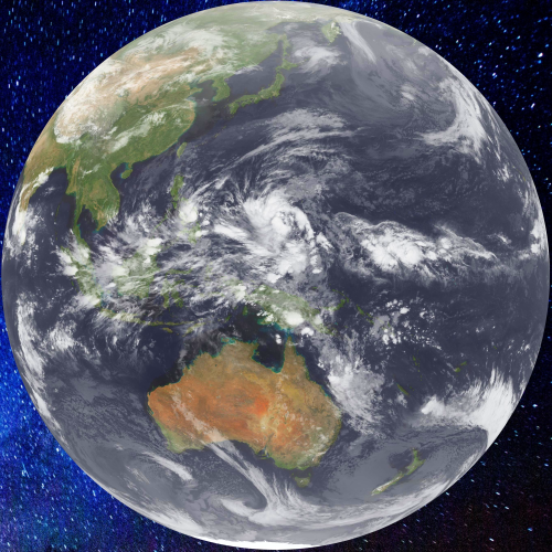
Kochi University
The Madden-Julian Oscillation continues to build and shift eastward. Linked to both the subtropical jet stream and the polar westerlies, the MJO signal is acting to energize and moisten the vigorous storm sequence now approaching the West Coast of North America. Note that the equatorial convection is moving northward, allowing dryness and heat to return to much of Australia.
GOES WEST
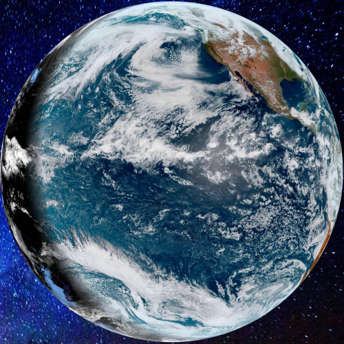
NOAA/NESDIS
There are three very well-defined jet streams in play across the northern Pacific Ocean. The Arctic flow is represented by a small 500MB vortex in the Aleutian Islands, while the polar and subtropical branches cover the entire space from the Gulf of Alaska to the equatorial regions. The problem is that all three entities will either merge or work in concert with one another to produce a string of days with extreme weather conditions from southern Canada into the Gulf States.
GOES EAST
NOAA/NESDIS
The broad trough and storm over the East Coast was accompanied by a deep 500MB cold pool and trough that dropped temperatures and created convective showers with rain, sleet and graupel. Clear and cooler conditions behind the storm will not last long as already there is energy moving out of the Desert Regions.
In South America, the deep mean easterlies are still viable from the equatorial Atlantic Ocean into the northern Andes Range. Recent tropical waves have trended weaker, but are still generating sizable thunderstorm activity from Brazil westward to Colombia and Ecuador. Further south, cold fronts are increasing in intensity with areas of cloudiness across Chile and Argentina.
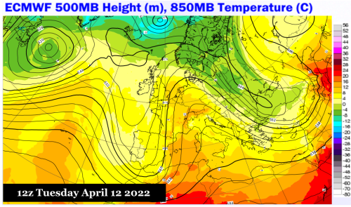
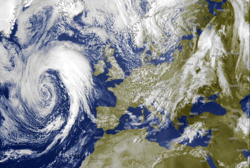
METEOSAT
ECMWF; METEOBLUE; EUMETSAT
Temperatures may not be as cold as has been seen in Europe, but the general weather pattern is still very active with new threats for heavy rain and thunderstorms from France into the Iberian Peninsula (see large storm approaching from the Atlantic Ocean). Italy may turn fair and warmer, but another deep negative-tilt trough from Russia into Poland and the Ukraine will suppress temperature and increase chances for both liquid and frozen precipitation.
One intense ITCZ wave is about to move into equatorial waters west of Guinea-Bissau, but otherwise the only concentrated precipitation is with a 500MB weakness and degraded polar front from South Africa into Mozambique.

.png?cb=640155)
.png?cb=227456)
.png?cb=380471)
.png?cb=556075)
.png?cb=578624)
.png?cb=468471)
.png?cb=979140)
.png?cb=91769)