WEATHERAmerica Newsletter, Saturday, May 7, 2022 at 8:00 PM CT; Summer JJAS 2022 Forecast
90 wyświetleń
Przejdź do pierwszej nieodczytanej wiadomości

Larry Cosgrove
7 maj 2022, 21:08:037.05.2022
do weather...@googlegroups.com
SUMMER SEASON (JJAS) FORECAST SUMMARY
(For North America And Surrounding Areas)
CIMSS
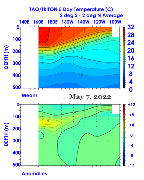
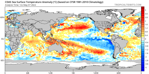
NOAA/PMEL
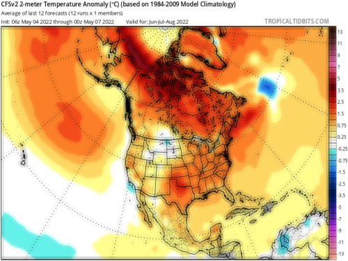
TropicalTidbits.Com (Dr. Levi Cowan) (2)
NOAA/PSL
WEATHERAmerica (4)
This summer outlook is somewhat of a scaled-down version of what I provide professionally to my clients. I use an analog+persistence+climatology system that measures up trends seen in winter and spring against past years, then takes current system development and what has transpired with chief measures of the past thirty years (yes, to account for the influence of global warming that is not seen in indicators from the 1950s through 1980s). Simply put, I apply a coat of warming/drying to any averaged result I get from the prediction that I have arrived at.
After all is said and done, this outlook runs differently from what we have seen in recent forecasts. Here is a quick breakdown of what I expect:
Summer Monsoon in the American Southwest:
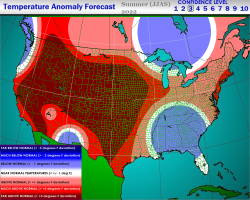
Near to above average, based on exceptionally strong Sonoran heat ridge with weakness from northern Mexico and Sea of Cortez and Gulf waters moisture sources producing strong pulse convection that will encompass the Desert Regions, but never fully reach Utah, Nevada and California. Strike time between mid-July and September 1.
Extreme Heat And Fire Hazards:
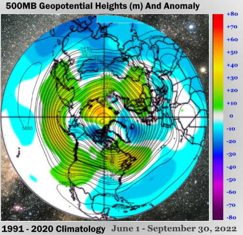
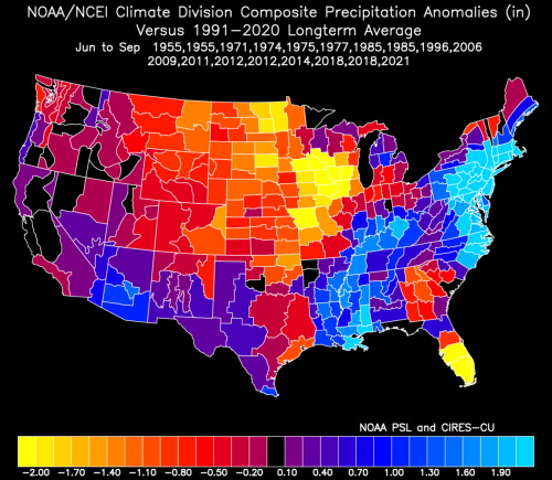
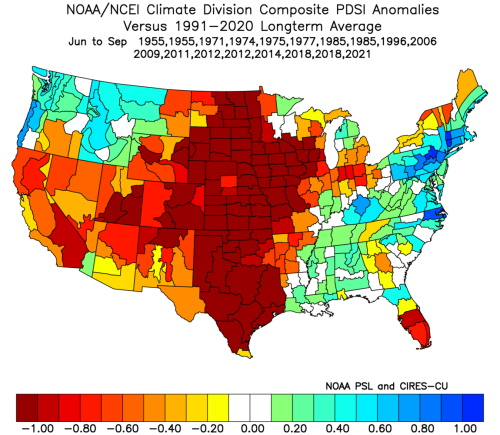
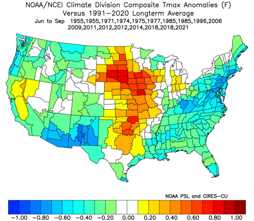
Many cases, mostly centered in locations west of the Mississippi River to the California shoreline of the Pacific Ocean. Ongoing dryness is a helpful indicator for future heat waves. There may be some jumps to excessive warmth in the Midwest and also in the Mid-Atlantic and New England, if and when the Bermuda High undergoes percolation. Conversely, a weakness or diffuse trough could form over the Southeast and in eastern Canada, so potential for hot air advection may be limited. The analog outlines also have a stronger cold front penetration rate in late August and September east of the Rocky Mountains.
Fire dangers will be quite high in a belt from New Mexico and Texas into the Dakotas, and later in the summer and fall be numerous in California and the interior of the Pacific Northwest. Recession of the ridge axis may not occur in the Golden State until November, so the typical incendiary season might be extended.
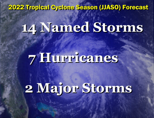
Tropical Cyclone Potential:
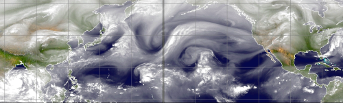
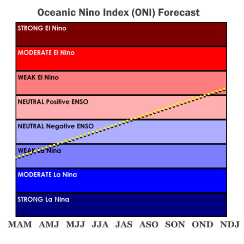
This is a tough call for many reasons, the least of which is not the ongoing cool water pattern in the central and eastern Pacific Ocean. Where many have been calling for a "three year La Nina", I have to voice a contrary estimation. The continued warming and wave pulsation out of the Indian Ocean will ultimately start to moderate sectors 4, 3.4 and 3. Very strong dual banding of the westerlies continues, and may not leave much room over the equatorial Atlantic Basin for growth of convective circulations. Note that the ITCZ has been very feeble in equatorial Africa for some time now, so chances for important warm core cyclogenesis has another mark against it. Recurvature is another possible issue, since the analog set argues for some suppression of the Bermuda High. When you add in the fact that recent years have been exceptionally active, but peaked in 2020, it makes sense to curtail the numbers back to a seasonal normal range.
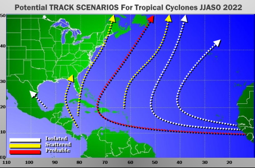
If the westerlies do form a broad trough over the eastern half of the continent in later summer and autumn, the two prime threat zones will be the countries rimming the Caribbean Sea and Atlantic Canada. But the Eastern Seaboard has a fair chance in September/October of seeing a stronger storm interact with a frontal structure. 2012, after all, is a dual analog entry.
If the westerlies do form a broad trough over the eastern half of the continent in later summer and autumn, the two prime threat zones will be the countries rimming the Caribbean Sea and Atlantic Canada. But the Eastern Seaboard has a fair chance in September/October of seeing a stronger storm interact with a frontal structure. 2012, after all, is a dual analog entry.
Prepared by Meteorologist LARRY COSGROVE on
Saturday, May 7, 2021 at 8:00 P.M. CT
Disclaimer:
The previous statements are my opinions only, and should not be construed as definitive fact. Links provided on this newsletter are not affiliated with WEATHERAmerica and the publisher is not responsible for content posted or associated with those sites.
Copyright 2021 by Larry Cosgrove
All rights reserved.
This publication may not be reproduced or redistributed in whole or in part without the expressed written consent of the author.
This publication may not be reproduced or redistributed in whole or in part without the expressed written consent of the author.
Odpowiedz wszystkim
Odpowiedz autorowi
Przekaż
Nowe wiadomości: 0