WEATHERAmerica Newsletter Weather Extremes And Global Satellite Discussion, Saturday, May 14, 2022
44 views
Skip to first unread message

Larry Cosgrove
May 14, 2022, 5:04:09 PM5/14/22
to weather...@googlegroups.com
WEATHER HAZARDS (During The Next 24 Hours)
SEVERE WEATHER OUTLOOK
(potential for tornadoes, damaging winds, and large hail within the next 24 hours)
(potential for tornadoes, damaging winds, and large hail within the next 24 hours)
Some Thunderstorms May APPROACH Severe Limits
Lower MI....S ON....OH....E KY....E TN....NC....VA....WV....PA....DE....MD....DC
ISOLATED Severe Thunderstorms
(Microbursts, Large Hail, Isolated Tornadoes)
W WI....SE MN....IA....SE NE....KS....MO....AR
Some Thunderstorms May APPROACH Severe Limits
WA....OR....ID
Some Thunderstorms May APPROACH Severe Limits
S AL....S GA....FL
HEAVY RAINFALL OUTLOOK
(potential for an inch or more total rainfall within the next 24 hours)
(potential for an inch or more total rainfall within the next 24 hours)
Isolated Locations In
PA....NJ....DE....MD....DC....VA
(QPF 1 - 2")
Isolated Locations In
MB....W ON
(QPF 1 - 2")
EXCESSIVE HEAT POTENTIAL
(risk of temperatures exceeding 95 deg F)
Scattered Locations In
C, S CA....NV....AZ....NM....TX....W LA....W AR....OK....SW KS....CO....UT
GLOBAL WEATHER SUMMARY
(a review of important weather features around the world)
IODC
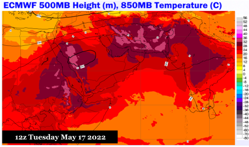

ECMWF, METEOBLUE, EUMETSAT
The heat ridge vs. the Monsoon Trough.
You have been reading about the hellish heat over the Indian subcontinent, with some sources in traditional, meteorological, and social media eclaiming the potential for the soaring temperatures to last all summer long. But a close look at satellite images reveals that the monsoon trough is trying to take shape over eastern India and the Bay of Bengal. Numerical model forecasts retrogress and expand the trough comlex so that by May 24, the core of the weakness is over Jammu/Kashmir. In this manner, a moisture axis will expand through South Asia and set up potential for diurnal (some orographic) convection that may trend in a heavy direction. Conversely, the giant heat ridge across the Red Sea and Arabian Peninsula will merge with the remnants of the ridging to its east, and create a wall of searing heat from the eastern Mediterranean Sea into Afghanistan and western Pakistan. If the center of the subtropical high verifies over the Persian Gulf, as expected, Iraq and Iran will start to lose chances for meaningful rainfall as temperatures reach near-record highs.
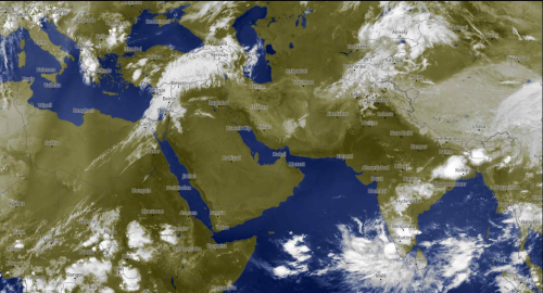
HIMAWARI 8
Kochi University
Moisture and energy from tropical forcing dominates the Orient and the Maritime Continent, with abundant cloudiness and precipitation present in much of the Pacific Basin. It is unusual to see such a pronounced southern branch flow, with a large storm near the International Dateline, this late in the year. The pattern in itself is a strong argument against a hyperactive hurricane season like those seen in the Atlantic Basin in the past few years.. The reason being, that westerly winds aloft will still be present across North America in June, and eliminate the potential for an early start for cases of warm-core cyclogenesis. On the other hand, the broad area of disturbed weather gives promise to an active, and widespread, Asian monsoon.
Note also that southern Australia has stronger cold frontal passages with a deep, Antarctic type trough. The northern portion of the subcontinent is fairly hot, but as austral winter approaches we may be seeing a turn away from recent mild/warm JJAS that have been common over the past twenty years.
GOES WEST

NOAA/NESDIS
Once again, the central and eastern Pacific Basin is cluttered with low-latitude westerlies and disturbances with pockets of cold air aloft. But unlike the pattern seen in the winter and early spring, these systems are disorganized and cover a smaller geographic area, which is typical of spring in weather over the western third of North America. Chances for precipitation will increase in the West, and thunderstorms may appear as far north as the Prairie Provinces. But computer models are somewhat reluctant to post serious amounts of precipitation below 40 N Latitude, owing to the strength of the Sonoran heat ridge.
GOES EAST
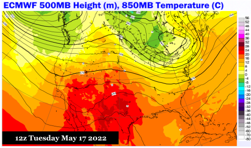

ECMWF, NOAA/NESDIS (2)
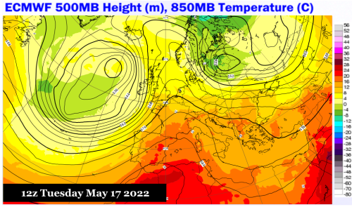
There are two critical features around North America. One is the aforementioned Sonoran heat ridge, which for the next six days will control the fate of the south central U.S., especially Texas, with hot and dry weather. The looming question is if the trough complex in the West will forcibly move the subtropical high into the Bermudan position, a scenario posted by the 12z May 14 ECMWF panels. That might lower temperatures (mostly via thunderstorm production) in the central Great Plains (Nebraska southward to Oklahoma), while at the same time bringing very hot air into Appalachia and the Eastern Seaboard.
Also take a look at the weakness and moisture fetch from Panama into a frontal structure off of the coastline of the Mid-Atlantic region. This dewpoint advection is what is behind the thunderstorm and stratiform rainfall production over the Corn Belt and the East Coast. More importantly, the trans-ridge gap is the source of what many believe to be a bogu hurricane prediction from the operational GFS scheme in teh 11-15 day period. While a convective grouping may arise and reach the eastern Gulf Coast, wind and SST profiles are not favorable for warm-core cyclogenesis.
You can split South America into three tiers. One, between the Caribbean shoreline and the Amazon Basin, is filled with diurnal thunderstorms in a warm and humid atmosphere (contributed by weak, westbound moving ITCZ waves). The other is the changeable central chamber of the continent, with some reach by cold frontal passages in the westerlies. Further south, in Chile and Argentina, colder air and disturbances from the southern Pacific Ocean have wiped out any trace of the warmth seen earlier in the fall.
METEOSAT

ECMWF, METEOBLUE, EUMETSAT
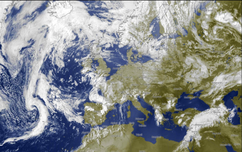
A recent run of warm temperatures over Europe is about to break down. Note the broad trough and cold low over the eastern Atlantic Ocean. This feature will be inching eastward, and by May 20 be located over the central portion of the subcontinent, restoring a synoptic-scale area of cool or normal readings from Scandinavia southward to the Mediterranean Sea.
Tropical wave and thunderstorm activity is trying to become re-established over equatorial Africa and the Atlantic Ocean. But low-latitude southwest flow and surrounding dry air masses will limit potential for needed rainfall, and will delay any chance of meaningful MDR warm-core cyclogenesis around the start day of the 2022 Atlantic Basin hurricane season.
Reply all
Reply to author
Forward
0 new messages