lastile confusion
349 views
Skip to first unread message

Zhou LingJun
Jul 27, 2022, 2:54:16 PM7/27/22
to LAStools - efficient tools for LiDAR processing
Hi, I have the following problem, please see the attached two images.
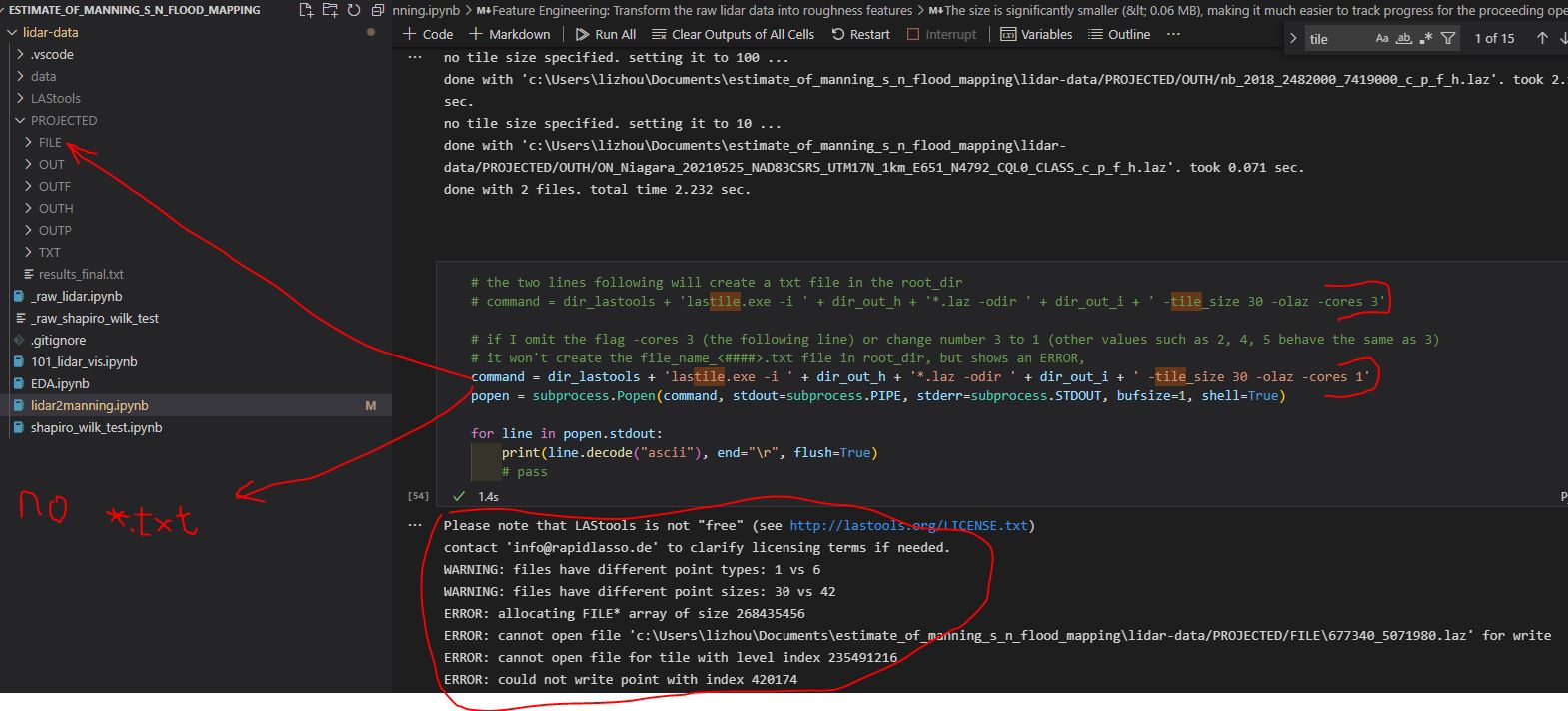
- In image 1, I ran cmd:
- lastile.exe -i <input-data> -odir <output_dir> -tile_size 30 -olaz -cores 3
- This creates a bunch of *.laz files in the <output_dir>, and a .txt file.
- Why does this command create a file_name_list.###.txt file in the root directory?
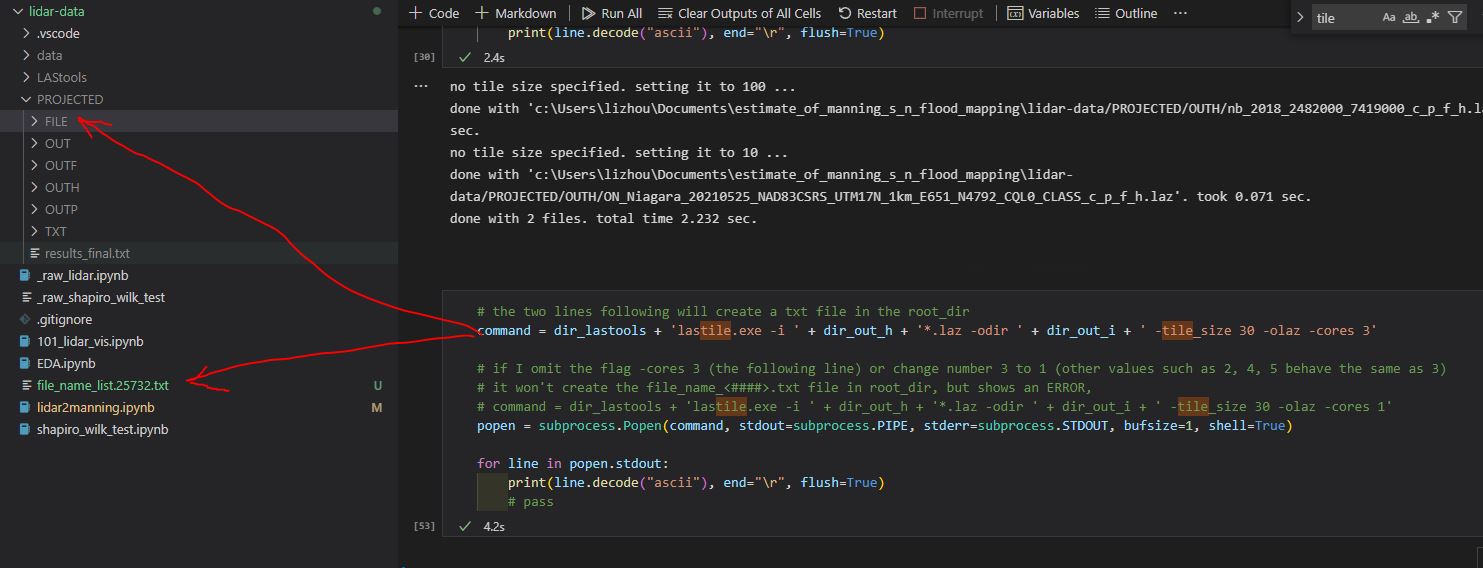
- In image 2, I ran cmd:
- lastile.exe -i <input-data> -odir <output_dir> -tile_size 30 -olaz -cores 1
- The only difference is the number of cores, the first one uses -cores 3, the second one uses -cores 1. This ALSO creates a bunch of the SAME *.laz files in the <output_dir>, which makes sense. However:
- Why does the 2nd command NOT create a .txt file in the root directory?
- Why does this command generate an output in notebook? (circled in red) And is there an ERROR in the output?
Thank you so much

Jochen Rapidlasso
Jul 28, 2022, 3:29:53 AM7/28/22
to LAStools - efficient tools for LiDAR processing
Hi
Zhou LingJun,
you run your LAStools command in an environment: Which environment is this?
Does the problem occur also if you run your commands in a traditional cmd terminal?
Please run the commands direct on a cmd promt and copy/past the result to your answer as text (so I can use copy/paste to reproduce this without the need to do a OCR on your screenshots ;))
Thanks for more information,
Jochen @rapidlasso
Zhou LingJun
Jul 28, 2022, 2:10:42 PM7/28/22
to last...@googlegroups.com
Hi Jochen
I ran the same command in cmd prompt/terminal. Here is the results
- When the <input_data> has MORE THAN 1 (LAZ) files, and -cores is more than 1, the cmd always creates a file_name_list.###.txt in the root directory every time we ran it.
- not sure why this happens, but whatever.
- When -cores 1, there is always an ERROR in the output, not sure why, but there must be enough cores for something??
- Please go and test on your side to see if you can repeat the same results. The variables are:
- the number of cores, -cores ##
- the number of LAZ files as <input_data>, try within ONLY 1 and more than 1
- Please note the ERROR messages when running the cmds.
- Not sure if -tile_size should have some constraints or not, but I picked it randomly.
Thank you
Jochen Rapidlasso <rapid...@gmail.com> 於 2022年7月28日 週四 凌晨2:29寫道:
--
Download LAStools at
https://rapidlasso.de
Manage your settings at
https://groups.google.com/g/lastools/membership
---
You received this message because you are subscribed to the Google Groups "LAStools - efficient tools for LiDAR processing" group.
To unsubscribe from this group and stop receiving emails from it, send an email to lastools+u...@googlegroups.com.
To view this discussion on the web visit https://groups.google.com/d/msgid/lastools/1743333c-1e65-4f73-8bcb-e8849ce384fen%40googlegroups.com.
Jochen Rapidlasso
Jul 28, 2022, 2:19:32 PM7/28/22
to LAStools - efficient tools for LiDAR processing
Hi Zhou LingJun,
you did not answer my question :( "Which environment is this?"
Then: You did not gave me the output of the lastile command. Please run it with -v option, to get even more information.
I tested your commands - and they run smooth, with -cores 1 and -cores 3
The program give some information during processing: This information is important - for you and me.
The program give some information during processing: This information is important - for you and me.
About your question of the file "file_name...txt": This is a temporary file, created during processing and then deleted.
If it is still there after the run the program did abort - and I am quite sure it delivered some useful output before:
Please deliver this output (again: use -v option).
Also: May a single input file is corrupt, not indexed, invalid,... did you check your files before?
You may should check your input files using lasinfo or lasvalidate to check if one of your input files is invalid.
Thanks,
Jochen @rapidlasso
Zhou LingJun
Jul 28, 2022, 3:43:50 PM7/28/22
to last...@googlegroups.com
Here are the outputs
Please note that LAStools is not "free" (see http://lastools.org/LICENSE.txt)
contact 'in...@rapidlasso.de' to clarify licensing terms if needed.
WARNING: files have different point types: 1 vs 6
WARNING: files have different point sizes: 30 vs 42
reading 7800263 points and tiling with size 300 ...
WARNING: written 7800263 points but expected 7373762 points
Please note that LAStools is not "free" (see http://lastools.org/LICENSE.txt)
contact 'in...@rapidlasso.de' to clarify licensing terms if needed.
WARNING: files have different point types: 1 vs 6
WARNING: files have different point sizes: 30 vs 42
Please note that LAStools is not "free" (see http://lastools.org/LICENSE.txt)
contact 'in...@rapidlasso.de' to clarify licensing terms if needed.
Please note that LAStools is not "free" (see http://lastools.org/LICENSE.txt)
contact 'in...@rapidlasso.de' to clarify licensing terms if needed.
WARNING: files have different point types: 1 vs 6
WARNING: files have different point sizes: 30 vs 42
WARNING: files have different point types: 1 vs 6
WARNING: files have different point sizes: 30 vs 42
took 0.07 sec.
took 0.173 sec.
Please note that LAStools is not "free" (see http://lastools.org/LICENSE.txt)
contact 'in...@rapidlasso.de' to clarify licensing terms if needed.
WARNING: files have different point types: 1 vs 6
WARNING: files have different point sizes: 30 vs 42
Please note that LAStools is not "free" (see http://lastools.org/LICENSE.txt)
contact 'in...@rapidlasso.de' to clarify licensing terms if needed.
WARNING: files have different point types: 1 vs 6
WARNING: files have different point sizes: 30 vs 42
took 0.113 sec.
took 0.196 sec.
Please note that LAStools is not "free" (see http://lastools.org/LICENSE.txt)
contact 'in...@rapidlasso.de' to clarify licensing terms if needed.
WARNING: files have different point types: 1 vs 6
WARNING: files have different point sizes: 30 vs 42
removing PROJECTED\FILE\651000_4792200.laz
took 0.003 sec.
Please note that LAStools is not "free" (see http://lastools.org/LICENSE.txt)
contact 'in...@rapidlasso.de' to clarify licensing terms if needed.
WARNING: files have different point types: 1 vs 6
WARNING: files have different point sizes: 30 vs 42
removing PROJECTED\FILE\651300_4792200.laz
took 0.005 sec.
Please note that LAStools is not "free" (see http://lastools.org/LICENSE.txt)
contact 'in...@rapidlasso.de' to clarify licensing terms if needed.
WARNING: files have different point types: 1 vs 6
WARNING: files have different point sizes: 30 vs 42
removing PROJECTED\FILE\651000_4792500.laz
took 0.003 sec.
Please note that LAStools is not "free" (see http://lastools.org/LICENSE.txt)
contact 'in...@rapidlasso.de' to clarify licensing terms if needed.
WARNING: files have different point types: 1 vs 6
WARNING: files have different point sizes: 30 vs 42
removing PROJECTED\FILE\651300_4792500.laz
took 0.004 sec.
Please note that LAStools is not "free" (see http://lastools.org/LICENSE.txt)
contact 'in...@rapidlasso.de' to clarify licensing terms if needed.
WARNING: files have different point types: 1 vs 6
WARNING: files have different point sizes: 30 vs 42
ERROR: allocating FILE* array of size 268435456
reading 7800263 points and tiling with size 30 ...
ERROR: cannot open file 'PROJECTED\FILE\677340_5071980.laz' for write
ERROR: cannot open file for tile with level index 235491216
ERROR: could not write point with index 420174
lastile.exe -i <data-dir>*.laz -odir <output-dir> -tile_size 300 -olaz -cores 1 -v
contact 'in...@rapidlasso.de' to clarify licensing terms if needed.
WARNING: files have different point types: 1 vs 6
WARNING: files have different point sizes: 30 vs 42
reading 7800263 points and tiling with size 300 ...
WARNING: written 7800263 points but expected 7373762 points
took 5.106 sec.
lastile.exe -i <data-dir>*.laz -odir <output-dir> -tile_size 300 -olaz -cores 2 -v
Please note that LAStools is not "free" (see http://lastools.org/LICENSE.txt)
contact 'in...@rapidlasso.de' to clarify licensing terms if needed.
WARNING: files have different point types: 1 vs 6
WARNING: files have different point sizes: 30 vs 42
Please note that LAStools is not "free" (see http://lastools.org/LICENSE.txt)
contact 'in...@rapidlasso.de' to clarify licensing terms if needed.
Please note that LAStools is not "free" (see http://lastools.org/LICENSE.txt)
contact 'in...@rapidlasso.de' to clarify licensing terms if needed.
WARNING: files have different point types: 1 vs 6
WARNING: files have different point sizes: 30 vs 42
WARNING: files have different point types: 1 vs 6
WARNING: files have different point sizes: 30 vs 42
took 0.07 sec.
took 0.173 sec.
Please note that LAStools is not "free" (see http://lastools.org/LICENSE.txt)
contact 'in...@rapidlasso.de' to clarify licensing terms if needed.
WARNING: files have different point types: 1 vs 6
WARNING: files have different point sizes: 30 vs 42
Please note that LAStools is not "free" (see http://lastools.org/LICENSE.txt)
contact 'in...@rapidlasso.de' to clarify licensing terms if needed.
WARNING: files have different point types: 1 vs 6
WARNING: files have different point sizes: 30 vs 42
took 0.113 sec.
took 0.196 sec.
Please note that LAStools is not "free" (see http://lastools.org/LICENSE.txt)
contact 'in...@rapidlasso.de' to clarify licensing terms if needed.
WARNING: files have different point types: 1 vs 6
WARNING: files have different point sizes: 30 vs 42
removing PROJECTED\FILE\651000_4792200.laz
took 0.003 sec.
Please note that LAStools is not "free" (see http://lastools.org/LICENSE.txt)
contact 'in...@rapidlasso.de' to clarify licensing terms if needed.
WARNING: files have different point types: 1 vs 6
WARNING: files have different point sizes: 30 vs 42
removing PROJECTED\FILE\651300_4792200.laz
took 0.005 sec.
Please note that LAStools is not "free" (see http://lastools.org/LICENSE.txt)
contact 'in...@rapidlasso.de' to clarify licensing terms if needed.
WARNING: files have different point types: 1 vs 6
WARNING: files have different point sizes: 30 vs 42
removing PROJECTED\FILE\651000_4792500.laz
took 0.003 sec.
Please note that LAStools is not "free" (see http://lastools.org/LICENSE.txt)
contact 'in...@rapidlasso.de' to clarify licensing terms if needed.
WARNING: files have different point types: 1 vs 6
WARNING: files have different point sizes: 30 vs 42
removing PROJECTED\FILE\651300_4792500.laz
took 0.004 sec.
...(and this just continues, never stop, had to Ctrl+c to break out)
lastile.exe -i <data-dir>*.laz -odir <output-dir> -tile_size 30 -olaz -cores 2 -v
Please note that LAStools is not "free" (see http://lastools.org/LICENSE.txt)
contact 'in...@rapidlasso.de' to clarify licensing terms if needed.
WARNING: files have different point types: 1 vs 6
WARNING: files have different point sizes: 30 vs 42
contact 'in...@rapidlasso.de' to clarify licensing terms if needed.
WARNING: files have different point types: 1 vs 6
WARNING: files have different point sizes: 30 vs 42
lastile.exe -i <data-dir>*.laz -odir <output-dir> -tile_size 30 -olaz -cores 3 -v
Please note that LAStools is not "free" (see http://lastools.org/LICENSE.txt)
contact 'in...@rapidlasso.de' to clarify licensing terms if needed.
WARNING: files have different point types: 1 vs 6
WARNING: files have different point sizes: 30 vs 42
ERROR: allocating FILE* array of size 268435456
reading 7800263 points and tiling with size 30 ...
ERROR: cannot open file 'PROJECTED\FILE\677340_5071980.laz' for write
ERROR: cannot open file for tile with level index 235491216
ERROR: could not write point with index 420174
lastile.exe -i <data-dir>*.laz -odir <output-dir> -tile_size 30 -olaz -cores 3 -v
Please note that LAStools is not "free" (see http://lastools.org/LICENSE.txt)
contact 'in...@rapidlasso.de' to clarify licensing terms if needed.
WARNING: files have different point types: 1 vs 6
WARNING: files have different point sizes: 30 vs 42
contact 'in...@rapidlasso.de' to clarify licensing terms if needed.
WARNING: files have different point types: 1 vs 6
WARNING: files have different point sizes: 30 vs 42
Zhou LingJun <lingjun...@gmail.com> 於 2022年7月28日 週四 下午2:20寫道:
Hi JochenI'm not sure what do you mean by "Which environment is this?"BestJochen Rapidlasso <rapid...@gmail.com> 於 2022年7月28日 週四 下午1:19寫道:
To view this discussion on the web visit https://groups.google.com/d/msgid/lastools/47665d71-6bf2-4c1d-9d4c-cbef859c5076n%40googlegroups.com.
Jochen Rapidlasso
Jul 28, 2022, 3:48:33 PM7/28/22
to LAStools - efficient tools for LiDAR processing
Thanks for the more detailed data.
So it seems all your input files are corrupt:
<<
WARNING: files have different point types: 1 vs 6
WARNING: files have different point sizes: 30 vs 42
WARNING: files have different point sizes: 30 vs 42
>>
The files are mixed with different point types and different point sizes. I think this causes the trouble.
The files are mixed with different point types and different point sizes. I think this causes the trouble.
Please fix the files first, so they produce no warnings and try again.
Optional you can send us a filelink and I will check the file here.
Best
Jochen @rapidlasso

Paul Manley
Jul 28, 2022, 4:21:54 PM7/28/22
to last...@googlegroups.com
Do the cores need to refer to the list of files and when only specifying one, LAStools doesn’t require a list of input files?
Paul
To view this discussion on the web visit https://groups.google.com/d/msgid/lastools/6130470a-a1fd-4dbd-9fa8-1ebb8cb9b222n%40googlegroups.com.
Regards,
Paul Manley
Jochen Rapidlasso
Jul 28, 2022, 5:01:54 PM7/28/22
to LAStools - efficient tools for LiDAR processing
Thanks for the files.
I did not post them to the public cause you told they are confidential.
First I fixed the issues:
WARNING: files have different point types: 1 vs 6
WARNING: files have different point sizes: 30 vs 42
PERFORMANCE ERROR: input files are not indexed. multi-core tiling will have
horrible I/O performance and totally overload the file
system. first run 'lasindex -i *.laz -cores 2' across
the input to spatially index all LAS or LAZ files. You
can force operation without spatial indexing by adding
the switch '-unindexed' to the command line.
las2las -i 1.laz -set_point_type 6 -set_point_size 42 -o 11.laz
las2las -i 2.laz -set_point_type 6 -set_point_size 42 -o 22.laz
lasindex -i 11.laz 22.laz
Then I checked the files itself:
11.laz:
min x y z: 676351.74 5071106.46 67.75
max x y z: 677382.45 5072137.01 90.24
22.laz:
min x y z: 651173.75 4792000.00 73.964
max x y z: 652000.00 4792129.29 74.596
There is a lot of space inbetween - most is "nothing", therefore
most of the file will be deleted after creation.
Taking the bounding box around this you got a range of
min x y 651173.75 4792000.00
max x y 677382.45 5072137.01
range = 26209 280137
I did not post them to the public cause you told they are confidential.
First I fixed the issues:
WARNING: files have different point types: 1 vs 6
WARNING: files have different point sizes: 30 vs 42
horrible I/O performance and totally overload the file
system. first run 'lasindex -i *.laz -cores 2' across
the input to spatially index all LAS or LAZ files. You
can force operation without spatial indexing by adding
the switch '-unindexed' to the command line.
las2las -i 1.laz -set_point_type 6 -set_point_size 42 -o 11.laz
las2las -i 2.laz -set_point_type 6 -set_point_size 42 -o 22.laz
lasindex -i 11.laz 22.laz
Then I checked the files itself:
11.laz:
min x y z: 676351.74 5071106.46 67.75
max x y z: 677382.45 5072137.01 90.24
22.laz:
min x y z: 651173.75 4792000.00 73.964
max x y z: 652000.00 4792129.29 74.596
There is a lot of space inbetween - most is "nothing", therefore
most of the file will be deleted after creation.
Taking the bounding box around this you got a range of
min x y 651173.75 4792000.00
max x y 677382.45 5072137.01
range = 26209 280137
With Tilesize of 300 this result into
tiles in x/y dir = 88 934
tiles in total (x*y) = 82192 (!!)
This is a lot.
And I am not sure if this make sense.
lastile.exe -i *.laz -odir out -tile_size 300 -olaz -cores [n] -v
will run, bit it takes a while (and you should not press ctrl-c) until all 82192 files are created (and then most of them deleted because they are empty).
may you better run file by file:
lastile.exe -i 11.laz -odir out -tile_size 300 -olaz -cores 3 -v
lastile.exe -i 22.laz -odir out -tile_size 300 -olaz -cores 3 -v
This makes more sense.
It seems you do not have a license of LAStools:
Working with small files without a license should work perfect for testing.
Working with large files without license will run into other limitations.
So if you want to work beside of testing you should may buy a license.
Best,
Jochen @rapidlasso
Zhou LingJun
Jul 29, 2022, 1:27:54 PM7/29/22
to last...@googlegroups.com
Hi Jochen
Thank you for looking into this.
We're aware of the license issue, let me talk to my team and get back to you.
Best regards
To view this discussion on the web visit https://groups.google.com/d/msgid/lastools/0d35268d-ead9-4951-9a75-b3a529ee1cean%40googlegroups.com.
Zhou LingJun
Aug 9, 2022, 4:52:11 PM8/9/22
to last...@googlegroups.com
Hi Jochen
So we actually have license for ArcGIS, I'm wondering if we use LAStools functionality from within ArcGIS, do we still need a license for say "lasheight, lastile"?
Thank you
Zhou LingJun <lingjun...@gmail.com> 於 2022年7月29日 週五 中午12:06寫道:
Jochen Rapidlasso
Aug 10, 2022, 2:31:52 AM8/10/22
to LAStools - efficient tools for LiDAR processing
Yes :)
Jochen @rapidlasso

Jorge Delgado García
Aug 15, 2022, 7:19:53 AM8/15/22
to last...@googlegroups.com
Dear Zhou,
Indeed LAStools requires its own license if you want to use it to its full potential, as you can check in the information of the company responsible for its development (Rapidlasso GmbH) https://lastools.github.io/LICENSE.txt and see the prices depending on the entity and use https://rapidlasso.com/pricing/.
LAStools is a totally independent program from ArcGIS, therefore, the license purchased from ESRI does not include its use. LAStools works as a plugin in ArcGIS (although it can also be used in QGIS or independently).
The modules that you indicate do not have free use, therefore the output of the unlicensed version can be slightly distorted after certain point limits are exceeded. after certain point limits are exceeded. Control output in the console (aka "the black window") informs the user whenever this happens.
Jorge Delgado
University of Jaén (Spain)
jdel...@ujaen.esTo view this discussion on the web visit https://groups.google.com/d/msgid/lastools/CA%2Bmtrd-4cuMBWPMsjrQ3bFYEoH%2BcZy6EZ9%2BmZaw3Z_mZXrk9mw%40mail.gmail.com.
--

Reply all
Reply to author
Forward
0 new messages