Anyone know about cycling Death Valley
197 views
Skip to first unread message

Tim
Nov 5, 2017, 8:39:08 PM11/5/17
to RBW Owners Bunch
I'll be taking the Hunqapillar, Roadeo and either the Hilsen or MAP out there for some camping and cycling here in the next couple of weeks camping and doing a lot of riding. Any advice?

dougP
Nov 5, 2017, 8:52:00 PM11/5/17
to RBW Owners Bunch
Tim:
People tend to underestimate the size of Death Valley. Some of did a trip where we camped at Texas Spring & did rides out of there for a few days. Dante's view is one serious climb. The view is almost worth the effort. Further north in the valley are a few campgrounds but primitive. I believe there is one with water. Even in winter you need lots of water as it's very dry. Check the elevations at various places you plan to ride. There is lots of elevation gain. Plan for wind. Hunq w/large tires is the ticket. Early AM photos can be awesome, and fantastic night skies.
dougP

George Schick
Nov 5, 2017, 10:22:06 PM11/5/17
to RBW Owners Bunch
If you do a search on this blog using the keys "death valley" up will pop a number posts from the past, including well documented coverage of the Death Valley Double Century by riders like Eric Norris. Some of these might be helpful.

Christopher Cote
Nov 6, 2017, 7:55:59 AM11/6/17
to RBW Owners Bunch
I spent a week there in 2011, but on a motorcycle, not a bicycle. I'll echo previous sentiments about the scale of the place. It's huge. And steep. You're either climbing or descending one side or the other at all times. Check the NPS road reports they put out each morning. Weather can be dramatic.
I think I liked the Panamint range side, and Panamint valley the best. Panamint springs campground is a good base camp. Ballarat is pretty cool. There's old mining cabins outside the park you can stay in. No power or water, though.
Scotty's Castle is worth a visit.
Have fun and post some pics when you get back!
Chris

Jonathan Neve
Nov 6, 2017, 9:22:45 AM11/6/17
to RBW Owners Bunch
I rode there last week, from Badwater Basin to the peak of White Mountain. Cached water along the way at a few different spots. Temperature range was 28-99 degrees.
Here’s a link to the Strava file: https://www.strava.com/activities/1253071477
Scotty’s Castle is closed due to crazy flooding, unfortunately. However, I loved the route we took to get to White. We didn’t see any cars between mile 40 and mile 165. Great place to (carefully) have a bike adventure.
Here’s a link to the Strava file: https://www.strava.com/activities/1253071477
Scotty’s Castle is closed due to crazy flooding, unfortunately. However, I loved the route we took to get to White. We didn’t see any cars between mile 40 and mile 165. Great place to (carefully) have a bike adventure.

Jim Bronson
Nov 6, 2017, 11:59:02 AM11/6/17
to RBW Owners Bunch
Epic Suffer Score, indeed. Was this some kind of event?
Christopher Cote
Nov 6, 2017, 12:06:22 PM11/6/17
to RBW Owners Bunch
I didn't realize Scotty's Castle was still closed. I heard about the damage back when it happened, but I figured it would be open now. I just read up on it at the NPS website, and the extent of the damage. Wow.
Chris

StewUtah
Nov 7, 2017, 10:45:02 AM11/7/17
to RBW Owners Bunch
On the Appaloosa? I just requested to follow you on Strava. You have certainly put the miles on this year :)
Jonathan Neve
Nov 7, 2017, 1:59:51 PM11/7/17
to rbw-owne...@googlegroups.com
I did this ride on a Cannondale SuperX with 45mm WTB Riddlers.
Eh, mileage wise I’ve slipped quite a bit, but thanks! Last year I was already to 10k. Alas, real life takes its toll.
J
--
You received this message because you are subscribed to a topic in the Google Groups "RBW Owners Bunch" group.
To unsubscribe from this topic, visit https://groups.google.com/d/topic/rbw-owners-bunch/OMP1gfXwxeQ/unsubscribe.
To unsubscribe from this group and all its topics, send an email to rbw-owners-bun...@googlegroups.com.
To post to this group, send email to rbw-owne...@googlegroups.com.
Visit this group at https://groups.google.com/group/rbw-owners-bunch.
For more options, visit https://groups.google.com/d/optout.
dougP
Nov 8, 2017, 2:17:41 PM11/8/17
to RBW Owners Bunch
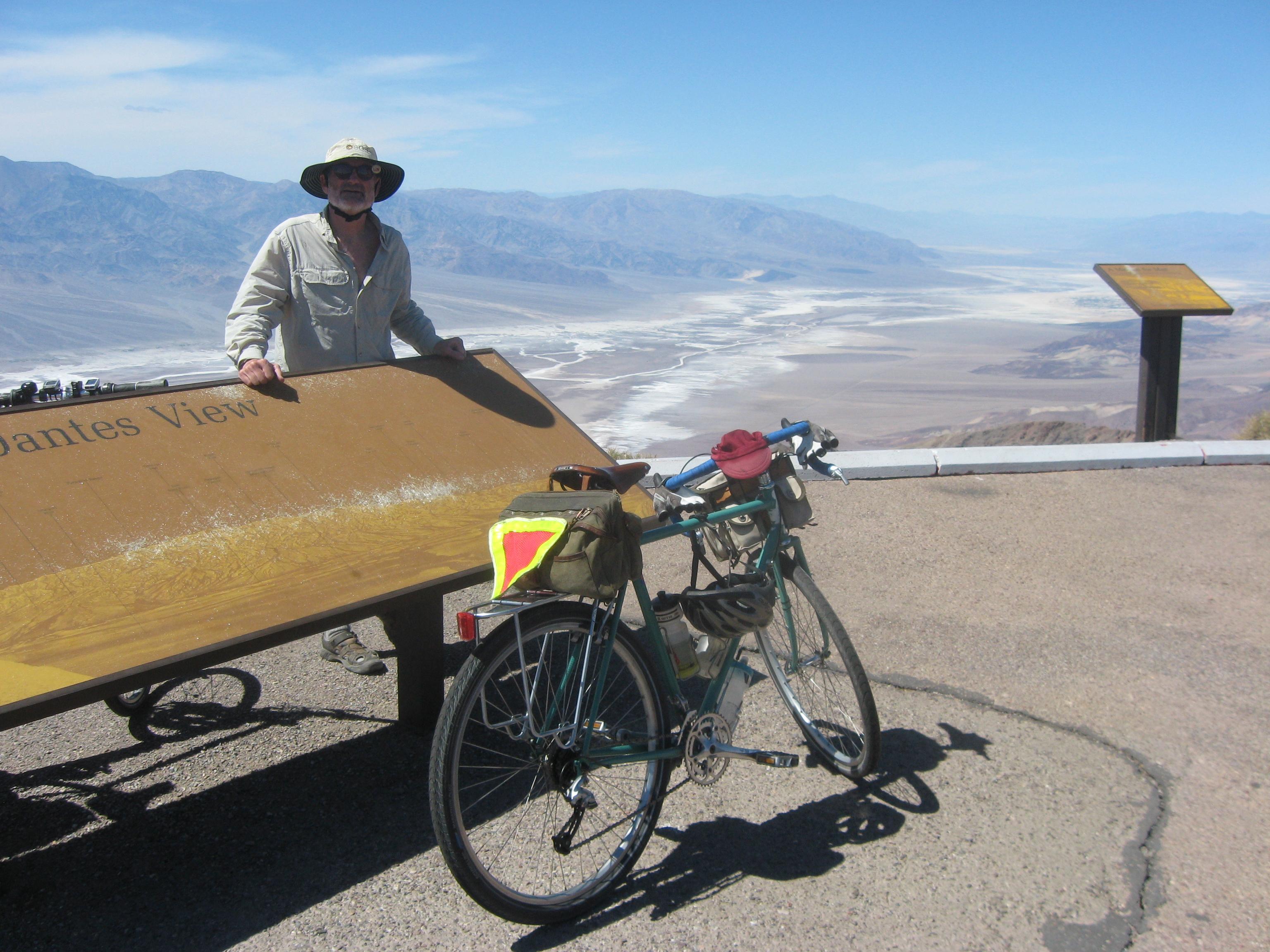
Just took the time to find a couple of photos. This was April 2013. You have to track it down but there is a "Stovepipe Well" and a story explaining the name. My notes show that the climb from Texas Spring to Dante's View is 5,400' in approx 25 miles. One of the guys who attempted the climb noted he was doing 4 mph with 4 miles to go; should be there in an hour. Then at 3 miles to go he was down to 3 mph; still another hour. He did the math & decided the downhill option was more attractive.
dougP
On Sunday, November 5, 2017 at 5:39:08 PM UTC-8, Tim wrote:

Ryan Fleming
Nov 8, 2017, 2:53:29 PM11/8/17
to RBW Owners Bunch
Who's the scruffy character? Is it you? Whoever it is the scenery looks like something out of Mad Max or High Plains Drifter or something
dougP
Nov 8, 2017, 3:07:47 PM11/8/17
to RBW Owners Bunch
Yours truly. As to the scenery, that's why it's called "Dante's View". Wild. There's a lot of variety in Death Valley.
dougP
dougP
Tim
Nov 8, 2017, 5:41:52 PM11/8/17
to RBW Owners Bunch
I'm looking forward to the ride to Dante's View.

Jon Spangler
Nov 9, 2017, 12:35:49 AM11/9/17
to RBW Owners Bunch
Tim,
Gorgeous country, some of my favorite ever.
Probably dry as a bone most of the time and it could also be hot, so LOTS of water and hydration awareness is required.
The weather in the desert can change in an instant and it is unforgiving territory.
(Just because it is mild now does not mean you will have mild weather all during your trip.) ;-)
You may also get snowed on and/or have below-freezing temps this time of year. And it does rain in Death Valley, too: if it does,
make sure you are out of and away from washes, gullies, canyon bottoms, etc.. top avoid flash floods.
It can also be windy as hell, so be prepared and ALWAYS guy out your tent. (Prepare for windy, cold, winter weather but be
ready to strip and stay cool if it heats up.
Check the weather forecasts and the long-range predictions as your departure date approaches:
And call the park headquarters for the latest in weather forecast, expected conditions, and road conditions as you plan your trip.
Oh, and be prepared to have USAF jets overhead almost every day...
Enjoy!
Jon Spangler
Alameda, CA
On Sunday, November 5, 2017 at 5:39:08 PM UTC-8, Tim wrote:

Steve S
Nov 12, 2017, 11:53:40 AM11/12/17
to RBW Owners Bunch
If you are planning to go to Furnace Creek area, then:
Consider the dirt road into Echo Canyon. Entrance is not far from Furnace Creek. Echo Canyon gives you near zero car traffic, very interesting canyon views, and a mine about 9 miles. If you are setup to bike/camp, there are places not far from the mine where camping is allowed. No water on this route, so you may want to cache water, or carry a lot of water.
Consider the dirt road into Echo Canyon. Entrance is not far from Furnace Creek. Echo Canyon gives you near zero car traffic, very interesting canyon views, and a mine about 9 miles. If you are setup to bike/camp, there are places not far from the mine where camping is allowed. No water on this route, so you may want to cache water, or carry a lot of water.
On Sunday, November 5, 2017 at 5:39:08 PM UTC-8, Tim wrote:
Reply all
Reply to author
Forward
0 new messages