New combined dataset: Co-ordinates and IDs of UK rail stations, TIPLOCs & other locations
1,779 views
Skip to first unread message

Carl Partridge
Jul 11, 2014, 7:38:23 AM7/11/14
to openrail...@googlegroups.com
Hi all
Please find attached a merged dataset of UK rail locations with the various unique ID codes and Latitude/Longitude co-ordinates. These are derived from:
3. The TipLoc->Stanox mappings as found in the CORPUS data.
Data fields are as follows:
| name | description | tiploc | crs | nlc | stanox | notes | longitude | latitude | isOffNetwork | timingPointType |
I've performed some cleaning and de-duplication; as far as I'm aware this is the best it gets in terms of data quality for now. Note that not all lat/lng co-ordinates are necessarily correct.
Do with this what you will!
Best,
Carl
Carl Partridge
FatAttitude Ltd / Transix

Steve Ardagh-Walter
Jul 17, 2014, 5:05:37 AM7/17/14
to openrail...@googlegroups.com
Here's a kml version of Carl's csv file for the 6000 - odd locations which have lats & longs
Most appear good looking at them in Google Earth - but there's an impressive secret network of several hundred undersea sites I was totally unaware of as well as some interesting sites in the Peak district etc ;)
Just picking one of these wet spots, I can't see an obvious correction or error factor. If there is value in cleaning this up and no-one's doing this already ( ... ?), other than a manual cleanup, the next step would probably be to match location names with the google geocoding api
Steve
Carl Partridge
Jul 17, 2014, 5:34:29 AM7/17/14
to openrail...@googlegroups.com
Steve
Thanks for posting that; it's great to see the data evolve.
I suspect that the rogue underwater sites are the result of 'placeholder' values in the original dataset, which were never updated to reflect the real-world coordinates of the locations. But that's entirely conjecture on my part, somebody out there who maintained the original data may be able to offer some insight into this.
There is definitely value to be had to the community in further cleaning the data, although I won't have any spare time myself, so do go ahead and process this if you are so-inclined. If you send me a CSV of any corrected lat/lngs (indexed by whatever code is most appropriate, e.g. TIPLOC) I'm happy to merge these back into the original data, or feel free to do so yourself.
First thing that would be helpful is to strip out the obvious incorrect coordinates and replace them with null values.
If you take things further than that, you'd need to manually review any auto-generated results obtained from geocoding. This is to guard against incorrect matches (e.g. Newcastle Upon Tyne versus Newcastle Under Lyme) etc. Plus, there's the issue of exactly where to place the coordinate, which I believe has been discussed before without resolution. Personally, I'd opt for a coordinate that is on the physical track itself if possible. It depends what people use the data for and how intelligent any routing algorithms are that make use of the coordinates.
bw,
Carl

Mike J
Oct 19, 2014, 1:15:58 PM10/19/14
to openrail...@googlegroups.com
Hi!
Few points.
I made comparison between google geolocation data coordinates and coordinates in this kml file. About 50% of coordinates bring up near values. (distance less than 5 km) I guess those are right. I haven't done this for all data and there still remains manual work after this.
I can make excel file from these (Stanox, tiploc, coordinates..) and show there what coordinates should be reviewed or reset... I tried to find stations corodinates from google map and other mapservices but it is really slow process.. I could share locations to different excel file and put them to github... ie. 100 stations / file and then they could be manually investigated.
Please tell me if you got any ideas and let's discuss.
Mikko
-

Bobby Doherty
Nov 6, 2014, 9:04:48 AM11/6/14
to openrail...@googlegroups.com
I too have been looking for a source of accurate lat/lons of tiplocs.
I extracted Ordnance Survey Meridian 2 stations and converted them to kml, see attached. The station locations appear to be accurate, but other locations such as junctions are missing.
Hope it helps.
Bobby
I extracted Ordnance Survey Meridian 2 stations and converted them to kml, see attached. The station locations appear to be accurate, but other locations such as junctions are missing.
Hope it helps.
Bobby

Peter Hicks
Nov 6, 2014, 11:18:39 AM11/6/14
to Bobby Doherty, openrail...@googlegroups.com
Hi Bobby
On 6 Nov 2014, at 14:04, Bobby Doherty <robert.jo...@gmail.com> wrote:
I too have been looking for a source of accurate lat/lons of tiplocs.
I extracted Ordnance Survey Meridian 2 stations and converted them to kml, see attached. The station locations appear to be accurate, but other locations such as junctions are missing.
There isn’t an open set of coordinates for TIPLOCs. The Meridian2 data has the station_points and rail_ln_polyline data aligned, however if you plotted this on, say, another Ordnance Survey dataset that included railway lines, you’d find the station points are off a bit. Snapping points to the nearest line works most of the time, but there are also lines not included in the Meridian2 data. For example, the red lines on the map below between Cricklewood and Acton aren’t in the Meridian2 data:
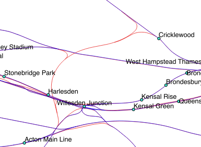
A further problem is that, where there are different TIPLOCs on different lines (e.g. Bushey below), the Meridian2 data shows this as one line splitting off in to two with one station point, however the actual geography of the network (in red) is two lines, with one TIPLOC for the main line route, and one for the Overground route on the left:

I’m hoping there’ll be a solution to this from NR at some point, although I am struggling to get a 100% up-to-date set of geospatial data internally too - everyone seems to have their own stash or data set!
Peter
Bobby Doherty
Nov 7, 2014, 9:24:55 AM11/7/14
to openrail...@googlegroups.com, robert.jo...@gmail.com
I was aware it contained only the stations, but the other information about the accuracy and missing track sections is new if not surprising, so thanks Peter.
I had looked at the national grid references used in the Train Planning feed, but found them to be unreliable too.
I was considering investigating data from OpenStreetMap, how accurate have people found the tracks & stations (I'm guessing they won't have all the tiplocs) there?
Bobby
I had looked at the national grid references used in the Train Planning feed, but found them to be unreliable too.
I was considering investigating data from OpenStreetMap, how accurate have people found the tracks & stations (I'm guessing they won't have all the tiplocs) there?
Bobby

K Müller
Feb 18, 2016, 6:30:38 AM2/18/16
to A gathering place for the Open Rail Data community, robert.jo...@gmail.com
Hello Peter,
I'm conscious this post is quite old, but are there any updates or new datasets with the lat/long of all TIPLOCs?
Overall there are 10879 TIPLOCs in total but coordinates published (for example on NATPAN) are only 2600 or so. It would be great to get hold of coordinates from the missing ones.
There are many ways to extract coordinates automatically, for example using googlemaps, but Google doesn't know the junctions either, so I am running out of options to get the coordinates..
Any suggestions would be appreciated.
On Thursday, 6 November 2014 16:18:39 UTC, Peter Hicks wrote:
Peter Hicks
Feb 18, 2016, 6:31:54 AM2/18/16
to K Müller, A gathering place for the Open Rail Data community, robert.jo...@gmail.com
Hello
On 18 Feb 2016, at 11:30, 'K Müller' via A gathering place for the Open Rail Data community <openrail...@googlegroups.com> wrote:I'm conscious this post is quite old, but are there any updates or new datasets with the lat/long of all TIPLOCs?
Overall there are 10879 TIPLOCs in total but coordinates published (for example on NATPAN) are only 2600 or so. It would be great to get hold of coordinates from the missing ones.
There are many ways to extract coordinates automatically, for example using googlemaps, but Google doesn't know the junctions either, so I am running out of options to get the coordinates..
Any suggestions would be appreciated.
Check out https://www.whatdotheyknow.com/request/geographical_information_on_tipl - it has about 9,000 of them.
Peter

Matt Carlson
Oct 5, 2017, 12:22:33 PM10/5/17
to A gathering place for the Open Rail Data community
I combined the Freedom Of Information TIPLOC co-ordinates (as mentioned above by Peter) with the network (NWK records) data from the geography file (from 2016 or 2017_ReferenceData.gz), and it works a lot better than the LOC co-ordinates contained in those files. I wonder whether these more correct co-ordinates will eventually make it into the Reference Data?
I have noted the following:
- There are about 64 incorrect locations in the FOI data (often clustered together) - I've marked these as 'bad' for now, and excluded them;
- There may be some missing TIPLOCS - e.g. Solihull / SOLIHUL is one;
- There are many 'hyperlinks' in the routes, an example shown is on the GWML;

The oddly-located TIPLOCs identified so far are below. They seem to be either located in the 'wrong' version of the same name, e.g. the 'wrong' Alresford / Bourne End / Beeston etc., or are often dumped in a cluster in a seemingly random place:
"ALRSFRD";"ALRESFORD"
"AVIGCMT";"AVIGNON C M T"
"AVIGVIL";"AVIGNON VILLE"
"BARRDCG";"BARRY DOCKS DOW CHEMICALS"
"BARRDNS";"BARRY DKS ABP NONSHIPMENT"
"BARRDUN";"BARRY DOCKS DUNN BROS"
"BCSTES";"BICESTER NORTH ENG SDG"
"BEST344";"BESTON SIGNAL 344"
"BEST918";"BEESTON SIG TN4918"
"BEST931";"BEESTON SIG TN4931"
"BESTGBR";"BEESTON SIMS METALS GBRF"
"BESTHST";"BEESTON HEADSHUNT"
"BESTRR";"BEESTON RUN ROUND"
"BORGSTM";"BOURG ST MAURICE"
"BORN412";"BOURNE END SIGNAL WT1412"
"BORN414";"BOURNE END SIGNAL WT1414"
"BORN419";"BOURNE END SIGNAL WT1419"
"BORN421";"BOURNE END SIGNAL WT1421"
"CALAFGV";"CALAIS FRETHUN GARE VGRS"
"CALAFT";"CALAIS FRETHUN (TUNNEL)"
"CHAT65";"CHATBURN OVERBRIDGE 65"
"CREWSSN";"CREWE SSN SIGNAL BOX"
"CRKL539";"CRICKLEWOOD SIGNAL 539"
"CRKLLAF";"CRICKLEWOOD LAFARGE"
"CRKLSCS";"CRICKLEWOOD SCS (GBRF)"
"CROFFHH";"CROFT QUARRY FLHH"
"FENN715";"FENNY COMPTON SIG. OL7150"
"GRTN";"GRANGETOWN (CLEVELAND)"
"HIGHBYA";"HIGHBURY & ISLINGTON"
"HIGHBYE";"HIGHBURY AND ISLINGTON ELL"
"HONDEGM";"HONDEGHEM"
"HRGY419";"HARRINGAY SIG K85"
"JARRGIN";"TYNE DOCK INTERMODAL GBRF"
"KINBTLP";"KINBRACE TIMBER LOADING PT"
"LEAGSDG";"LEAGRAVE TAMPER SDG"
"LEST325";"LEICESTER SIGNAL LR325"
"LEST327";"LEICESTER SIGNAL 327"
"LILLE";"LILLE EUROPE"
"LISK9";"LISKEARD SIG 9"
"MARNELV";"MARNE-LA-VALLEE"
"MRKS872";"MARKS TEY SIGNAL L872"
"MRKSDG";"MARKET HARBOROUGH CCE SDG"
"MRSLSTC";"MARSEILLE ST CHARLES"
"NBLYAGB";"NORTH BLYTH ALCAN GBRF"
"NBLYEWS";"NORTH BLYTH (DBS)"
"NBLYGBF";"NORTH BLYTH GBRF"
"NBLYRP";"NORTH BLYTH RP GBRF"
"NEWB824";"NEWBURY GROUND SIG 824"
"NMPTEMA";"NORTHAMPTON EMU ARRIVALS"
"RBRTRPG";"DONCASTER ROBERTS RD RP GB"
"REDHLS";"REDHILL L.H.S."
"REDHY";"REDHILL GOODS LOOP"
"RTHG849";"RUTHERGLEN SIGNAL G849"
"RTHG873";"RUTHERGLEN SIGNAL G873"
"RUGLGBR";"RUGELEY PS (FGD) GBRF"
"SKPT031";"SKIPTON STH JN SIG L4031"
"THET15";"THETFORD GROUND SIGNAL T15"
"TOTON04";"TOTON SIGNAL 4604"
"TRFDFLF";"TRAFFORD PARK SDGS (FLF)"
"WHMP236";"WEST HAMPSTEAD SIGNAL 236"
"WHMP467";"WEST HAMPSTEAD SIGNAL 467"
"WHMP617";"WEST HAMPSTEAD SIGNAL 617"
"WOOLS1";"WOOL SIGNAL S1"
"WROXHMR";"WROXHAM RECP."
Hope that helps!
Matt
Peter Hicks (Poggs)
Oct 5, 2017, 12:29:40 PM10/5/17
to Matt Carlson, A gathering place for the Open Rail Data community
Hi Matt
On 5 Oct 2017, at 17:22, Matt Carlson <matt.ca...@gmail.com> wrote:I combined the Freedom Of Information TIPLOC co-ordinates (as mentioned above by Peter) with the network (NWK records) data from the geography file (from 2016 or 2017_ReferenceData.gz), and it works a lot better than the LOC co-ordinates contained in those files. I wonder whether these more correct co-ordinates will eventually make it into the Reference Data?
I doubt it - the system that the geography file comes from doesn’t have that much of a use for them, so I can’t see that system being updated with data that nothing downstream really uses (apart from all the Open Data users)
I have noted the following:
- There are about 64 incorrect locations in the FOI data (often clustered together) - I've marked these as 'bad' for now, and excluded them;
- There may be some missing TIPLOCS - e.g. Solihull / SOLIHUL is one;
- There are many 'hyperlinks' in the routes, an example shown is on the GWML;
These ‘hyperlinks’ are fine - the network links exist because they’re effectively sections which are individually timed. There are many TIPLOCs where trains only need a time if they have an activity (i.e. not just ‘pass’), such as Kings Langley just north of Watford Junction. The next mandatory timing point is Bourne End Junction, so there will be a link from Watford Junction to Bourne End junction, plus a link from Watford Junction to Kings Langley for trains which stop there, probably one to Apsley too for trains which call at Watford and Apsley, but not Kings Langley - and also one from Watford to Hemel Hempstead for trains which don’t stop at Kings Langley or Apsley.
The oddly-located TIPLOCs identified so far are below. They seem to be either located in the 'wrong' version of the same name, e.g. the 'wrong' Alresford / Bourne End / Beeston etc., or are often dumped in a cluster in a seemingly random place:
"ALRSFRD";"ALRESFORD""AVIGCMT";"AVIGNON C M T""AVIGVIL";"AVIGNON VILLE""BARRDCG";"BARRY DOCKS DOW CHEMICALS""BARRDNS";"BARRY DKS ABP NONSHIPMENT"
"BARRDUN";"BARRY DOCKS DUNN BROS”
At a guess, somebody went through and populated the ‘location’ of these TIPLOCs at some time in the past and wasn’t aware of the similarly spelled names at completely different parts of the country. I bet Garston (Herts) and How Wood (Herts) are mixed up with Garston (Merseyside) and Howwood (Strathclyde).
Peter

petermount
Oct 5, 2017, 12:42:36 PM10/5/17
to A gathering place for the Open Rail Data community
Ah, didn't send to the group, so here goes again :-(
I've done something similar, combining that data set along with corpus, nr CIF timetable, darwin reference etc which I'm using partially for better naming of certain tiplocs but also for their positions, e.g. finding stations near to a post code is one example.
Any how, some for a station are way off (I've corrected a few), but it's been a low priority project of late.
Anyhow, you can see some tiplocs appear in the North Sea, so there's a few wrong:

Reply all
Reply to author
Forward
0 new messages