Large and accurate map of North America.

blake...@hotmail.com
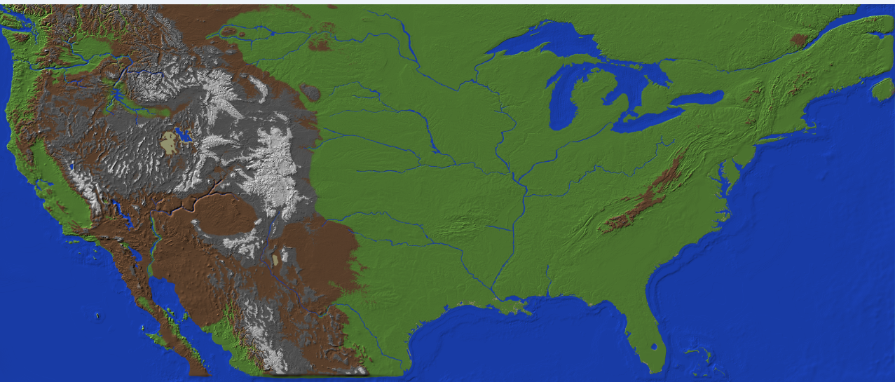
This is a map i have developed using a grayscale height map
NASA made.
Development took around 7 months.
Would anyone like to use this?
[IMG]http://i21.photobucket.com/albums/b283/blakealley/America-Map-1A_4125696_lrg.png[/IMG]
I am also making a map with Early European Colonial Cities. like Williamsburg, St. Augustine and New Orleans. as well as a few native American settlements. Coming soon.

Williamsburg VA.

St. Augustine FL.

Elisabeth Bellamy
blake...@hotmail.com
Thank you for the kind words. If you need any help with your Mexico map let me know id be more then happy to assist.
Michael Harvey
blake...@hotmail.com
The process was not simple haha. I did write a crude blog about the process on Planet Minecraft but it turned out to be more of a rant then a how to haha. you can find that here. I never did the math on the scale of the map. I expanded the NASA Image 206% and the map ended up being approximately 15000 blocks coast to coast and 6000 blocks Canada to mexico so the scale is quite large. The map is free for all to download here The America Map. I am in the long process of creating Colonial Cities and at this point i have about 6 out of a planned 25 done. however i wont be able to continue work after February 26th because i am shipping off to the Navy in an advanced computer field.

Joel Levin
The process was not simple haha. I did write a crude blog about the process on Planet Minecraft but it turned out to be more of a rant then a how to haha. you can find that here. I never did the math on the scale of the map. I expanded the NASA Image 206% and the map ended up being approximately 15000 blocks coast to coast and 6000 blocks Canada to mexico so the scale is quite large. The map is free for all to download here The America Map. I am in the long process of creating Colonial Cities and at this point i have about 6 out of a planned 25 done. however i wont be able to continue work after February 26th because i am shipping off to the Navy in an advanced computer field.
I am so happy that this Hobby of mine might actually be used for something good haha. when i was in grade school the only game we were allowed to play was Oregon trail. and i always died of dysentery ....
--

PJVermont
PJVermont
Owen Long
Owen Long
Network Manager (And Middle School Minecraft club advisor)
The Spence School
646.943.6830
-----Original Message-----
From: minecraft...@googlegroups.com [mailto:minecraft...@googlegroups.com]
Sent: Friday, December 21, 2012 3:07 PM
To: Owen Long; minecraft...@googlegroups.com
Subject: {Minecraft Teachers} Re: Large and accurate map of North America.
Importance: Low
The process was not simple haha. I did write a crude blog about the process on Planet Minecraft but it turned out to be more of a rant then a how to haha. you can find that[ http://www.planetminecraft.com/blog/making-a-real-map-the-long-endevor-and-why-nobody-does-it/ ] here. I never did the math on the scale of the map. I expanded the NASA Image 206% and the map ended up being approximately 15000 blocks coast to coast and
6000 blocks Canada to mexico so the scale is quite large. The map is free for all to download here [ http://www.planetminecraft.com/project/big-map-the-continent-of-north-america/ ]The America Map. I am in the long process of creating Colonial Cities and at this point i have about 6 out of a planned 25 done. however i wont be able to continue work after February 26th because i am shipping off to the Navy in an advanced computer field.
blake...@hotmail.com
Planet minecraft has banned my post for being unoriginal...
you removed my submission. i can understand that bumping my project may have been wrong and i should have better understood the rules behind update logs. my bad. but as for the unoriginality of the map. i have to say that is not true.
I spent 7 months of my life putting in the details on that map from the rivers lakes valleys biomes and natural land marks...
everything from ocean depths to sand on the beaches were hand made and not imported at all In contains resources and everything to make it a very legit map. your welcome to try it. i think you may have grossly oversimplified my work. and i must appeal your decision to remove my map from the site. 300 diamonds and it was never once on the popular reel. I put a ton of time and effort into the project and i must ask you to reconsider its removal.
I made a popular blog detailing the amount of work i put into this map you can find it here
http://www.planetminecraft.com/blog/making-a-real-map-the-long-endevor-and-why-nobody-does-it/
the response was as follows:
Look man im sorry. But importing height maps is not allowed. Next we will have people importing 3D files and posting them. etc.
Joel Levin
--

Michael Harvey
Michael Harvey
Michael Harvey
blake...@hotmail.com


John Calvert
Michael Harvey
Michael Harvey

Justin Eames
On Monday, January 7, 2013 2:37:28 PM UTC-5, Michael Harvey wrote:
Michael Harvey
blake...@hotmail.com
yes. the spawn is along the Mississippi in Louisiana. I figured that was a good central point to begin from. as far as fast travel goes the server method is the easiest. an online server can support fluid travel via Coordinates, warp points or portals. My personal favorite however is included in the Custom NPC mod. with this mod you can create an NPC make them look how you want, give them Scripts, and you can even use them as fast travel hubs. the original idea behind the colony map was to include cities and towns inhabited by fully scripted npcs who could give backstory and allow for some immersion into life in that era.
blake...@hotmail.com
here is a treat for anyone interested in the current state of development for the colony map of north america
Michael Harvey
blake...@hotmail.com
On Friday, January 11, 2013 2:26:46 PM UTC-8, Michael Harvey wrote:
That's awesome! The colonies look great too. I like the spiderwebs coming out of the chimneys. :)I'd love to know how you made this work. It would be a great lesson to show students how a three dimensional world can translate to a two dimensional map. Treasure hunt, anyone?

dparty6

Rick M
Rick M
Rick M

Eric
sithload
--
You received this message because you are subscribed to the Google Groups "Minecraft Teachers" group.
To unsubscribe from this group and stop receiving emails from it, send an email to minecraft-teach...@googlegroups.com.
For more options, visit https://groups.google.com/groups/opt_out.