Blank map after conversion of shapefile to .map (mapsforge)

Wagner de Carvalho Ferreira
I am currently developing an android app with mapsforge. And I need to display a shapefile with mapsforge.
I know that there were some post's about this subject here in this forum. However I've just started
work with all this (android and mapsforge). Sorry if this is a dumb question.
However I couldn't be able to figure it out what I am doing wrong.
I'm getting a blank map after converting .shp to .map
I downloaded brazil.map from http://download.geofabrik.de/south-america.html and follow the steps of
this link: https://groups.google.com/forum/#!topic/mapsforge-dev/WCpBoO1tA8M.
I'm using Merkaartor version 0.18.2 and the latest version of osmosis (0.45).
file:///home/wagner/maps/bb.map
That's the command that I used to do the conversion.
bin/osmosis --rx file=/home/wagner/maps/brazil.osm --sort --mw file=/home/wagner/maps/bb.map bbox=-23.805,-47.065,-23.383,-46.077 map-start-zoom=15 tag-conf-file=/home/wagner/maps/tagmap.xml
Could anyone please help me figure it out what am I doing wrong ?
Wagner
--
You received this message because you are subscribed to a topic in the Google Groups "mapsforge-dev" group.
To unsubscribe from this topic, visit https://groups.google.com/d/topic/mapsforge-dev/YW0ZvKLcEv4/unsubscribe.
To unsubscribe from this group and all its topics, send an email to mapsforge-dev+unsubscribe@googlegroups.com.
To post to this group, send email to mapsfo...@googlegroups.com.
Visit this group at https://groups.google.com/group/mapsforge-dev.
To view this discussion on the web visit https://groups.google.com/d/msgid/mapsforge-dev/b1d4d8dd-0dcd-487a-aa00-fe0e4524852c%40googlegroups.com.
For more options, visit https://groups.google.com/d/optout.

Emux
You don't need any shp files for that, those osm / pbf files already contain all the data.
Also it's recommended to use the compressed pbf files.
You need to take care the tag-mapping (if you use a custom one) to be in match with the render theme used later. i.e. the tags used in both should be similar and existent
See the default tag-mapping and theme as guides.
Also be careful with the bounding box you use, it's in degrees with the form: minLat,minLon,maxLat,maxLon.
e.g. in your tag-mapping you have only nodes (not ways / areas) and do those exist in the render theme?
Emux
Wagner
So ... just to clarify, I am developing an android app for agricultural area, and one of the scopes of this project is to display a shapefile in my app using mapsforge.
So, this path that I am following is correct ? or should I do that differently ?
--
You received this message because you are subscribed to a topic in the Google Groups "mapsforge-dev" group.
To unsubscribe from this topic, visit https://groups.google.com/d/topic/mapsforge-dev/YW0ZvKLcEv4/unsubscribe.
To unsubscribe from this group and all its topics, send an email to mapsforge-dev+unsubscribe@googlegroups.com.
To post to this group, send email to mapsfo...@googlegroups.com.
Visit this group at https://groups.google.com/group/mapsforge-dev.
To view this discussion on the web visit https://groups.google.com/d/msgid/mapsforge-dev/4eae75ee-eca6-2388-828b-ea293c2141b0%40gmail.com.
Emux
(I thought that you want to render only OSM data from Geofabrik, that's why I said that you could just use their osm/pbf files for convenience)
Ok you want to include in the map also custom data from shp files, that's a little different.
As you already found, Mapsforge map-writer is a plugin for Osmosis tool which uses for input mainly osm/pbf files.
So you need to convert any other format (e.g. shp) in osm/pbf, see here a list of more such tools.
The path you follow is indeed correct. Most important thing you need to take care is the element tags.
For any element entering the map file, there are tags that describe it.
Those tags must exist in the tag-mapping AND in the render theme you'll use next.
And if they are not regular OSM tags, but your custom ones, you have to add them.
Let's take for example the declaration in tag-mapping for place=city.
This rule exists also in render theme describing its rendering.
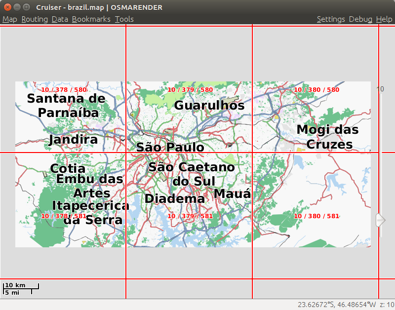
e.g. if I use the following command
osmosis --rb file=brazil-latest.osm.pbf --mw file=brazil.map bbox=-23.805,-47.065,-23.383,-46.077
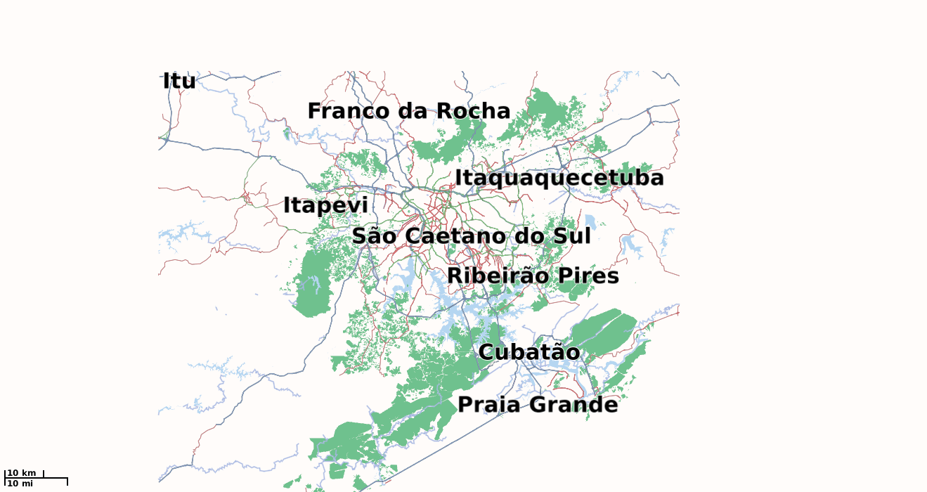
then a filled brazil.map of 16.6MB is built (see screenshot).
The bounding box seems right inside Brazil, I don't know if the conversion of shp files was right.
Have you opened the .osm file with Josm?
Emux
Wagner
wagner@wagner-pc:~/osmosis$ bin/osmosis --rb file=/home/wagner/maps/brazil-latest.osm.pbf --mw file=/home/wagner/maps/brazil.map bbox=-23.805,-47.065,-23.383,-46.077
set 27, 2016 1:26:45 PM org.openstreetmap.osmosis.core.Osmosis run
INFO: Osmosis Version 0.45
set 27, 2016 1:26:46 PM org.openstreetmap.osmosis.core.Osmosis run
INFO: Preparing pipeline.
set 27, 2016 1:26:46 PM org.mapsforge.map.writer.osmosis.MapFileWriterTask <init>
INFO: mapfile-writer version: mapsforge-map-writer-0.6.1
set 27, 2016 1:26:46 PM org.mapsforge.map.writer.osmosis.MapFileWriterTask <init>
INFO: mapfile format specification version: 3
set 27, 2016 1:26:46 PM org.openstreetmap.osmosis.core.Osmosis run
INFO: Launching pipeline execution.
set 27, 2016 1:26:46 PM org.openstreetmap.osmosis.core.Osmosis run
INFO: Pipeline executing, waiting for completion.
set 27, 2016 1:26:47 PM org.mapsforge.map.writer.osmosis.MapFileWriterTask process
INFO: start reading data...
set 27, 2016 1:27:15 PM org.openstreetmap.osmosis.core.pipeline.common.ActiveTaskManager waitForCompletion
SEVERE: Thread for task 1-rb failed
java.lang.OutOfMemoryError: Java heap space
at gnu.trove.map.hash.TLongObjectHashMap.rehash(TLongObjectHashMap.java:157)
at gnu.trove.impl.hash.THash.postInsertHook(THash.java:388)
at gnu.trove.map.hash.TLongObjectHashMap.doPut(TLongObjectHashMap.java:248)
at gnu.trove.map.hash.TLongObjectHashMap.put(TLongObjectHashMap.java:222)
at org.mapsforge.map.writer.RAMTileBasedDataProcessor.addNode(RAMTileBasedDataProcessor.java:81)
at org.mapsforge.map.writer.osmosis.MapFileWriterTask.process(MapFileWriterTask.java:160)
at crosby.binary.osmosis.OsmosisBinaryParser.parseDense(OsmosisBinaryParser.java:138)
at org.openstreetmap.osmosis.osmbinary.BinaryParser.parse(BinaryParser.java:124)
at org.openstreetmap.osmosis.osmbinary.BinaryParser.handleBlock(BinaryParser.java:68)
at org.openstreetmap.osmosis.osmbinary.file.FileBlock.process(FileBlock.java:135)
at org.openstreetmap.osmosis.osmbinary.file.BlockInputStream.process(BlockInputStream.java:34)
at crosby.binary.osmosis.OsmosisReader.run(OsmosisReader.java:45)
at java.lang.Thread.run(Thread.java:745)
set 27, 2016 1:27:15 PM org.openstreetmap.osmosis.core.Osmosis main
SEVERE: Execution aborted.
org.openstreetmap.osmosis.core.OsmosisRuntimeException: One or more tasks failed.
at org.openstreetmap.osmosis.core.pipeline.common.Pipeline.waitForCompletion(Pipeline.java:146)
at org.openstreetmap.osmosis.core.Osmosis.run(Osmosis.java:92)
at org.openstreetmap.osmosis.core.Osmosis.main(Osmosis.java:37)
at sun.reflect.NativeMethodAccessorImpl.invoke0(Native Method)
at sun.reflect.NativeMethodAccessorImpl.invoke(NativeMethodAccessorImpl.java:62)
at sun.reflect.DelegatingMethodAccessorImpl.invoke(DelegatingMethodAccessorImpl.java:43)
at java.lang.reflect.Method.invoke(Method.java:498)
at org.codehaus.plexus.classworlds.launcher.Launcher.launchStandard(Launcher.java:330)
at org.codehaus.plexus.classworlds.launcher.Launcher.launch(Launcher.java:238)
at org.codehaus.plexus.classworlds.launcher.Launcher.mainWithExitCode(Launcher.java:415)
at org.codehaus.plexus.classworlds.launcher.Launcher.main(Launcher.java:356)
at org.codehaus.classworlds.Launcher.main(Launcher.java:47)
--
You received this message because you are subscribed to a topic in the Google Groups "mapsforge-dev" group.
To unsubscribe from this topic, visit https://groups.google.com/d/topic/mapsforge-dev/YW0ZvKLcEv4/unsubscribe.
To unsubscribe from this group and all its topics, send an email to mapsforge-dev+unsubscribe@googlegroups.com.
To post to this group, send email to mapsfo...@googlegroups.com.
Visit this group at https://groups.google.com/group/mapsforge-dev.
To view this discussion on the web visit https://groups.google.com/d/msgid/mapsforge-dev/67219bfe-a6f3-f65a-a4b9-996b952c4386%40gmail.com.
Emux
JAVACMD_OPTIONS="-Xmx6g"
The -Xmx value should be based on your available RAM, try above and put smaller if problem.
Another thing to try is to use the type=hd parameter in command line for map-writer (see here).
That will use also the HD for the map creation but the process could take a lot longer.
The output of the command is a Mapsforge vector map file.
You will be able to include your data in a map file, see previous post for tag details.
Emux
Wagner
bin/osmosis --rb file=/home/wagner/maps/sao-paulo_brazil.osm.pbf --mw file=/home/wagner/maps/saopaulo.map bbox=-24.046,-47.120,-23.373,-46.176
So in order to do that I grepped the .osm file.
<tag k="landuse" v="allotments"/>
<tag k="landuse" v="basin"/>
<tag k="landuse" v="brownfield"/>
<tag k="landuse" v="cemetery"/>
<tag k="landuse" v="commercial"/>
<tag k="landuse" v="condominium"/>
<tag k="landuse" v="conservation"/>
<tag k="landuse" v="construction"/>
<tag k="landuse" v="events"/>
<tag k="landuse" v="farm"/>
<tag k="landuse" v="farmland"/>
<tag k="landuse" v="farmyard"/>
<tag k="landuse" v="forest"/>
<tag k="landuse" v="garages"/>
<tag k="landuse" v="grass"/>
<tag k="landuse" v="greenfield"/>
<tag k="landuse" v="industrial"/>
<tag k="landuse" v="landfill"/>
<tag k="landuse" v="meadow"/>
<tag k="landuse" v="military"/>
<tag k="landuse" v="orchard"/>
<tag k="landuse" v="park"/>
<tag k="landuse" v="plant_nursery"/>
<tag k="landuse" v="port"/>
<tag k="landuse" v="quarry"/>
<tag k="landuse" v="railway"/>
<tag k="landuse" v="recreation_ground"/>
<tag k="landuse" v="religious"/>
<tag k="landuse" v="reservoir"/>
<tag k="landuse" v="residential"/>
<tag k="landuse" v="retail"/>
<tag k="landuse" v="trees"/>
<tag k="landuse" v="village_green"/>
<tag k="landuse" v="vineyard"/>
<tag k="landuse" v="yes"/>
<tag k="landuse" v="condominium"/>
<tag k="landuse" v="conservation"/>
<tag k="landuse" v="events"/>
<tag k="landuse" v="garages"/>
<tag k="landuse" v="park"/>
<tag k="landuse" v="plant_nursery"/>
<tag k="landuse" v="port"/>
<tag k="landuse" v="religious"/>
<tag k="landuse" v="trees"/>
--
You received this message because you are subscribed to a topic in the Google Groups "mapsforge-dev" group.
To unsubscribe from this topic, visit https://groups.google.com/d/topic/mapsforge-dev/YW0ZvKLcEv4/unsubscribe.
To unsubscribe from this group and all its topics, send an email to mapsforge-dev+unsubscribe@googlegroups.com.
To post to this group, send email to mapsfo...@googlegroups.com.
Visit this group at https://groups.google.com/group/mapsforge-dev.
To view this discussion on the web visit https://groups.google.com/d/msgid/mapsforge-dev/859045d1-4e64-28c8-59d2-ba3d1f3b75f0%40gmail.com.
Emux
Java default Xmx is often small, so you can try -Xmx6g or another value first to see what happens.
And you don't need a smaller osm/pbf in order to build a smaller map file, you simply change the map-writer's bounding box parameter.
In default tag-mapping we have included the most commonly used tags, I'm sure there many others.
In order to produce a full map with extra elements you need to modify original tag-mapping, not erasing it completely and inserting only your tags. Because in that case you'll produce an empty map.
So take the original and just modify the part you need, leaving the rest file 'as is'.
Then you can feed it to the map-writer with the parameter "tag-conf-file" and your mapping file path.
Of course then you have to edit the osmarender.xml theme accordingly adding the new tags with rules for how to be rendered.
- The tag-mapping is used in map-writer to guide it what tags to include in the built map (not shp) file.
- The render theme (e.g. osmarender) is used in the application for the reader to know how to render that map.
I suggest to invest some time and study our documentation, e.g. map-writer and render themes where we describe those and many other things.
Emux
Wagner
I haven't had the time to look into the issue related to the supposedely lack of memory that I ran into when I ran the osmosis command. Bu t I will soon.
Emux,
When I ran that command that you have exemplified in one of your previous e-mail, I got a map identical with the map that I have downloaded from here.
If I understood correctly, when I ran the osmosis command, the tag-mapping (as it is) is used by default. That's why I got a full map exactly as the map that I have downloaded from the link above.
So the tag-mapping file have all the tags to generate a full map. Correct ?
I read the documents about map-writer and rendertheme that you have mentioned, and things became a little bit more clear. However this subject is not so easy to grasp, that's why I have some many doubts yet. Once again sorry about that!
So, if I remove some tags that it's not important to my project, I'll be able to generate a map with only the data that it's important to me. Is that correct ?
However I must to figure out what are the minimum tags that a custom tag-mapping file must have, to show only data related to landuse for instace, so I don´t end up with a blank map. Is my understanding correctly so far ?
I was poking around in the tag-mapping file, and I've learned that it has two main sections (main tags), which are POIS and WAYS. Those two tags are somehow linked. I've just haven't figure out how yet.
I was trying to generate a map, with a custom tag-mapping with only landuse tags, which is by the way included in the WAYS section. I even sent this file (tag-sp.xml) to you earlier. However I end up with a blank map. That's how I fond out that I needed more than landuse tags in this file.
My question is how can I know what tags do I need to provide, to have in a simple custom tag-mapping file that can generates a map related to landuse or highway only for instance ? I know that the answer for this question could be in the links that you have mentioned earlier. But I could not understand how so far.
Wagner
--
You received this message because you are subscribed to a topic in the Google Groups "mapsforge-dev" group.
To unsubscribe from this topic, visit https://groups.google.com/d/topic/mapsforge-dev/YW0ZvKLcEv4/unsubscribe.
To unsubscribe from this group and all its topics, send an email to mapsforge-dev+unsubscribe@googlegroups.com.
To post to this group, send email to mapsfo...@googlegroups.com.
Visit this group at https://groups.google.com/group/mapsforge-dev.
To view this discussion on the web visit https://groups.google.com/d/msgid/mapsforge-dev/35397727-f56e-db9b-9974-d4a29f5c8dcf%40gmail.com.
Wagner
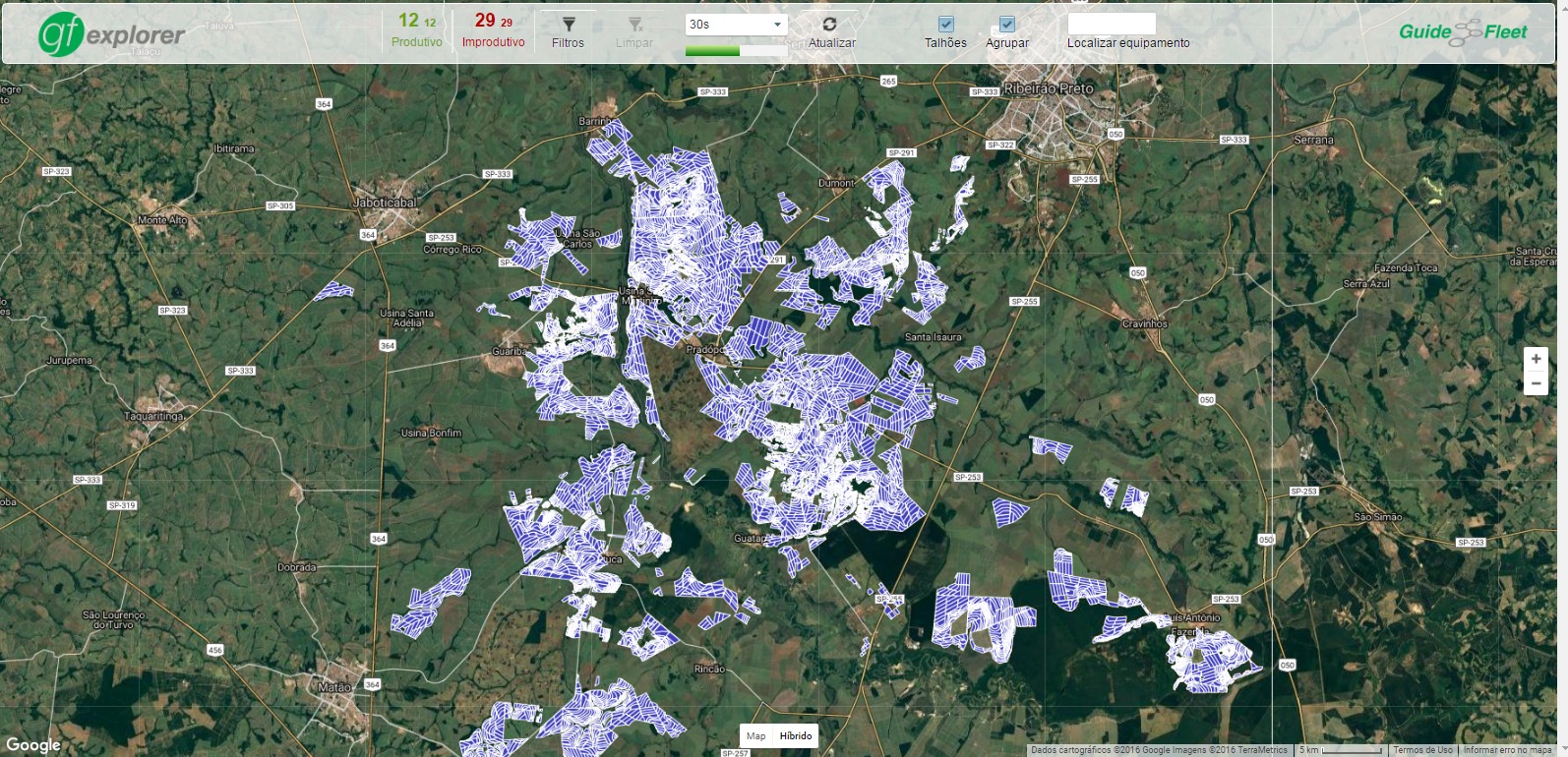
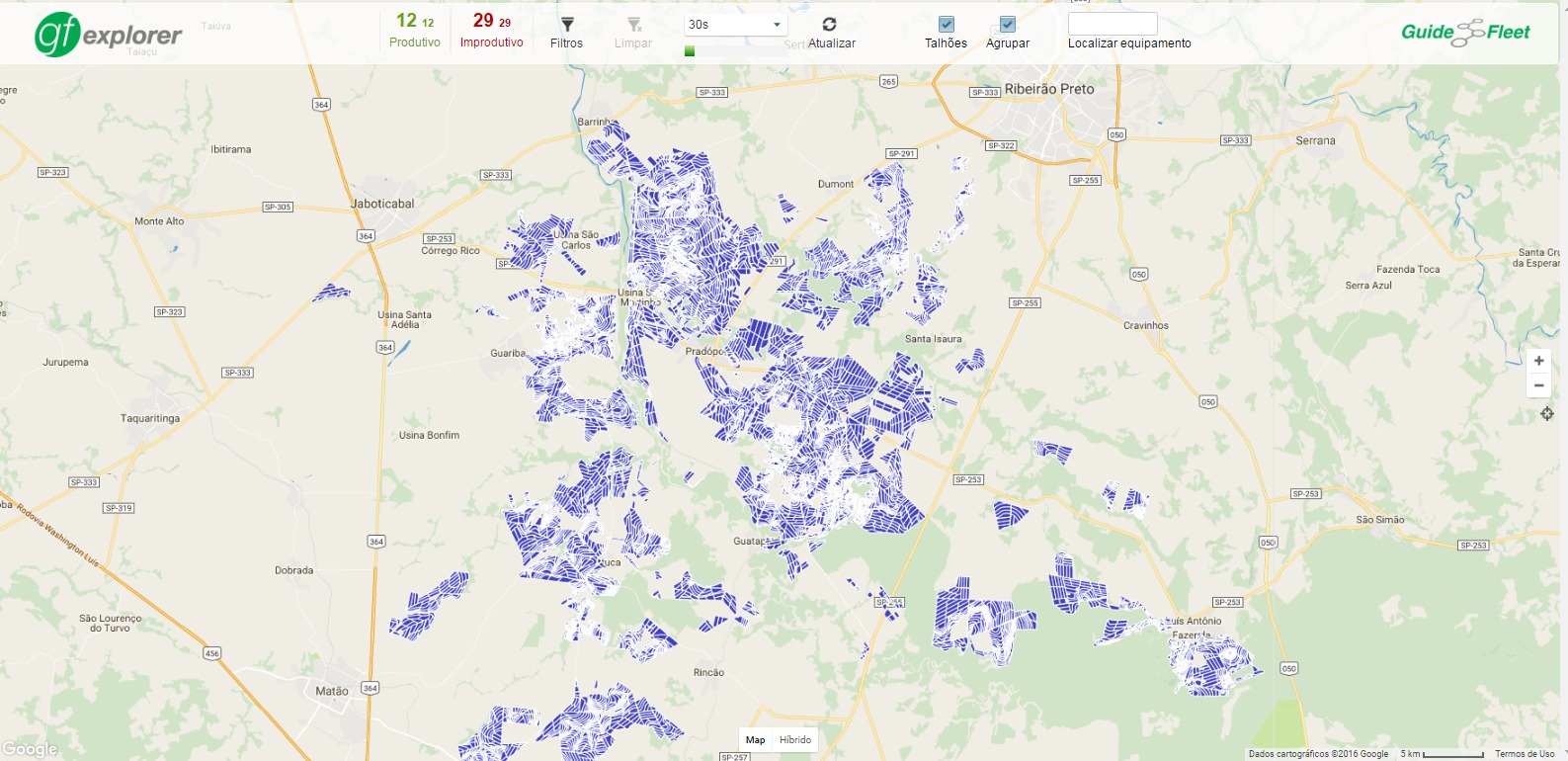
Another thing that I forgot to ask you is related to those shapefiles images that I sent you earlier.
Those images are shapefiles that were imported into google maps. So we have an image (shapes) over the map (google maps). Image over image.
The way I see, If I want a map similar to the map in those images, I have to customize the tag-mapping in order to have a map with the shapes that is related to my project.
So if I want to see in my map water(oceans, sea, lakes etc), I need to customize the tag-mapping with natural tags, if want to see only highways I have to customize the tag-mapping with highway tags and so on. Is my understanding correct?
If yes using mapsforge, the map will be a little different compared to the map in those images. I mean, there won't be an image (shape) over a map (google maps) like the ones in those images that I sent you. It will be just a map with the shapes (natural, highway, landuse) that I have predefined.
I don' t know if I was able to make myself clear. But could you understand my point ?
Emux
I haven't had the time to look into the issue related to the supposedely lack of memory that I ran into when I ran the osmosis command. Bu t I will soon.
So the tag-mapping file have all the tags to generate a full map. Correct ?
So, if I remove some tags that it's not important to my project, I'll be able to generate a map with only the data that it's important to me. Is that correct ? However I must to figure out what are the minimum tags that a custom tag-mapping file must have, to show only data related to landuse for instace, so I don´t end up with a blank map. Is my understanding correctly so far ?
My question is how can I know what tags do I need to provide, to have in a simple custom tag-mapping file that can generates a map related to landuse or highway only for instance ? I know that the answer for this question could be in the links that you have mentioned earlier. But I could not understand how so far.
Emux
So if I want to see in my map water(oceans, sea, lakes etc), I need to customize the tag-mapping with natural tags, if want to see only highways I have to customize the tag-mapping with highway tags and so on. Is my understanding correct?
Wagner
Thank you very much for your help.
I was able to run the osmosis command after setting the JAVACMD_OPTIONS="-Xmx6g" variable as you have said. That way I could generate a full map of Brazil with 17MB. Like you warned me this task took about 32 minutes.
I was also able to customize the tag-mapping in order to generate a map with only landuse tags.
Once again thank you very much for your support.
Emux,
I've just one more question, in order to proceed to the next phase of my project. I'd like to mark an area of the map. Suppose for a moment that I have a set of coordinates that create a rectangle (could be any other shape) for instance. Is it possible to mark this coordinates in the map and highlight this area in the map ?
Thanks in advance,
Wagner
--
You received this message because you are subscribed to a topic in the Google Groups "mapsforge-dev" group.
To unsubscribe from this topic, visit https://groups.google.com/d/topic/mapsforge-dev/YW0ZvKLcEv4/unsubscribe.
To unsubscribe from this group and all its topics, send an email to mapsforge-dev+unsubscribe@googlegroups.com.
To post to this group, send email to mapsfo...@googlegroups.com.
Visit this group at https://groups.google.com/group/mapsforge-dev.
To view this discussion on the web visit https://groups.google.com/d/msgid/mapsforge-dev/a0353d95-5f4b-d24c-0df6-bcc0736959af%40gmail.com.
Emux
I've just one more question, in order to proceed to the next phase of my project. I'd like to mark an area of the map. Suppose for a moment that I have a set of coordinates that create a rectangle (could be any other shape) for instance. Is it possible to mark this coordinates in the map and highlight this area in the map ?
Wagner
--
You received this message because you are subscribed to a topic in the Google Groups "mapsforge-dev" group.
To unsubscribe from this topic, visit https://groups.google.com/d/topic/mapsforge-dev/YW0ZvKLcEv4/unsubscribe.
To unsubscribe from this group and all its topics, send an email to mapsforge-dev+unsubscribe@googlegroups.com.
To post to this group, send email to mapsfo...@googlegroups.com.
Visit this group at https://groups.google.com/group/mapsforge-dev.
To view this discussion on the web visit https://groups.google.com/d/msgid/mapsforge-dev/e87dc857-04eb-591e-aa8a-fc019fe5ee4c%40gmail.com.