Map Maker Update - June 27, 2012

Sneha
The Map Maker team has been busy closing bugs and building new features. In this release we have made a concerted effort to eliminate some of your long standing grievances with the product. You can post your thoughts and suggestions on this update here.
The following issues reported through forums and issue tracker are now resolved:
| Issues Fixed | Issue Tracker Link | Forum Post Link |
| “Find near this point” now works better. | Issue 35 Issue 56 | http://goo.gl/BshF1, http://goo.gl/wGHCB |
| Convert any establishments to a building. | Issue 2102 | -- |
| Incorrect duplicate detection - showing political features and postal codes as duplicates for establishments. | Issue 1474 (partial) | -- |
| Pending 2.5D polygons will no longer obscure satellite imagery | -- | -- |
| Duplicate options and the marker will not be seen after cancelling, while adding a duplicate point. | -- | -- |
| Phone Numbers will be correctly displayed from left to right in Arabic interface | -- | -- |
| The height will be displayed on the country’s unit of measurement. | -- | -- |
| Improvements | Issue Tracker Link | Forum Post Link |
| Ability to edit profile photos and nickname | Issue 2220 | http://goo.gl/ZD2Nk |
| You can now have “Private” roads where there is no auto traffic. | Issue 1962 | http://goo.gl/kXwYy |
| Roads dug up for construction? You can now mark it as such in Map Maker. | Issue 1584 (partial) | -- |
Here’s a detailed look at the changes:
We’ve been hearing your thoughts on forums about introducing an option to
change your Map Maker profile photos and nicknames. Previously, this was only possible through Google Places.
It was a gaping hole that we should have closed. We're glad it’s now fixed!

As indicated in Issue tracker and forum post, including "Private" as a value under Priority was not logically accurate. To address this, we have introduced a new attribute, Road Access to qualify the accessibility of a road as a Private road or accessible to the general public. You have two options now: 1. Public 2. Private
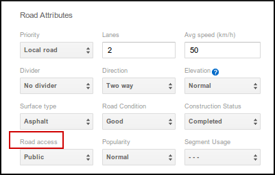
Additionally, the Accuracy attribute no longer has any impact on Maps and it was a rarely modified attribute in any case. We’ve removed this attribute and replaced this field with the Road Access field.

3. Introducing two new options for Construction Status Attribute
We’ve added two new options to better qualify the construction status of a road:
- Closed for maintenance : Roads that exist but are temporarily closed due to maintenance.
- Disturbed by maintenance: Roads undergoing maintenance, while remaining open to traffic

4. Political features and postal codes not shown as duplicates of establishments:
Previously, while adding new features, political features and postal codes were also mistakenly identified as possible duplicates. You will no longer have this issue.

5. Improved Find near this point option:
We have made some improvements to how Find near this point works, and this should resolve some of the complaints we have heard from all of you on forums regarding the results of find.
6.Pending 2.5D polygons will no longer obscure satellite imagery:
The 2.5D polygons on pending features were being rendered incorrectly in the hybrid view and obscuring a lot of the satellite imagery. This has been now fixed.
7. Building will now be interchangeable with most of the categories:
It was noted that not all business/non business categories can be converted to Building category. This has been fixed for you and now you’ll be able to change most of the categories to Building.
8. Duplicate options and the marker will not been seen after cancelling, while adding a duplicate point:
While adding a feature, the tool prompts for the possible duplicates of the feature that you’re adding. Once you select on any of the possible duplicate, it takes you to the merged left hand pane. It was observed that if you go ahead and click cancel on this page, there was a blank left pane appearing which leads nowhere. This is fixed.
9. The height will be displayed on the country’s unit of measurement:
There was some discrepancy on the unit in which height was displayed on Map Maker. This has been rectified and the height will appear as per the unit specified for that country.
10. Phone Numbers will be correctly displayed from left to right in Arabic interface:
It was observed that the phone numbers were displayed in the reverse order in the Arabic Map Maker interface. Thanks for reporting this. We’ve fixed this for you.
Thanks,
Sneha (on behalf of Map Maker Team, Google)