Re: [MI-L] REgistering the coordinates of a Raster Image
717 views
Skip to first unread message

Mats Elfström
Jul 31, 2012, 6:12:03 AM7/31/12
to mapi...@googlegroups.com
Hi Bob!
Two things to consider of great importance:
1/ Make sure that you use the correct coordsys/projection of your scanned map before you start entering control points.
2/ Make sure that the control points are evenly spaced over the area in question.
Consider using other control points nearby instead of those with large errors. The feature you see on the scanned map may not be the one it appears to be in your vector data.
HTH Mats.E
--
______________________________________________
Mats Elfström, Väpplingvägen 21, SE-227 38 LUND, Sweden
tel: +46 46 145959 / mob: +46 70 595 39 35
alt e-mail: mats.e...@telia.com
Two things to consider of great importance:
1/ Make sure that you use the correct coordsys/projection of your scanned map before you start entering control points.
2/ Make sure that the control points are evenly spaced over the area in question.
Consider using other control points nearby instead of those with large errors. The feature you see on the scanned map may not be the one it appears to be in your vector data.
HTH Mats.E
2012/7/31 bobsays48 <shua...@gmail.com>
Hi all, this might be a beginner question,but I am recently trying to register a scanned geological map, but it has constantly given me pixel errors and no matter how precise i tried to get it continues to give me error. I just want to ask around to see if they're is a more efficient to do it especially when it comes to a large scanned map ?--
You received this message because you are subscribed to the
Google Groups "MapInfo-L" group.To post a message to this group, send
email to mapi...@googlegroups.com
To unsubscribe from this group, go to:
http://groups.google.com/group/mapinfo-l/subscribe?hl=en
For more options, information and links to MapInfo resources (searching
archives, feature requests, to visit our Wiki, visit the Welcome page at
http://groups.google.com/group/mapinfo-l?hl=en
--
______________________________________________
Mats Elfström, Väpplingvägen 21, SE-227 38 LUND, Sweden
tel: +46 46 145959 / mob: +46 70 595 39 35
alt e-mail: mats.e...@telia.com

David R Sherrod
Jul 31, 2012, 6:33:24 AM7/31/12
to mapi...@googlegroups.com
How large is the pixel error?
For scanned maps, you should expect 1-2 pixel error commonly. It's distortion from using nonstable base materials and the nature of scanners. You can deduce the map dimension of your pixels once you get it projected, and then you'll have to decide the acceptable amount of error. If I'm scanning and registering a legacy map, and the pixel error is only 2-3, that may amount to 10 meters on the ground, and it's unlikely the original linework was placed with precision better than that.
-----------------------------------------
| From: | Mats Elfström <mats.e...@gmail.com> |
| To: | mapi...@googlegroups.com |
| Date: | 07/31/2012 03:12 AM |
| Subject: | Re: [MI-L] REgistering the coordinates of a Raster Image |
| Sent by: | mapi...@googlegroups.com |

AlexZ
Jul 31, 2012, 11:18:13 PM7/31/12
to mapi...@googlegroups.com
Hello Shuang,
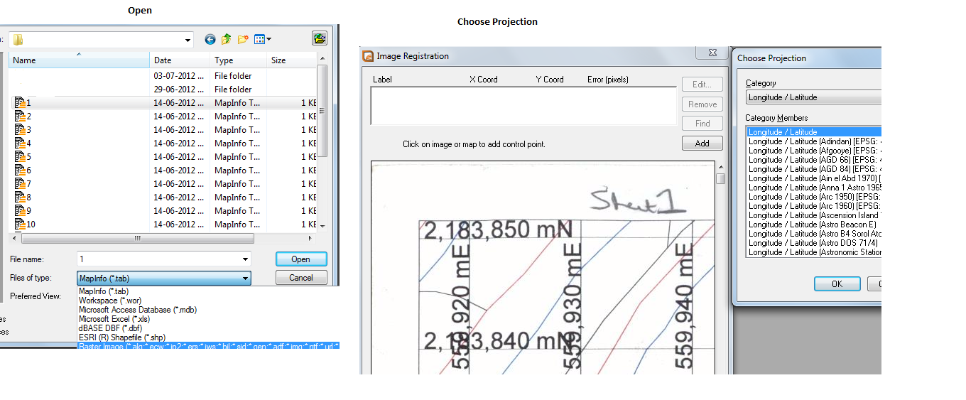
I noticed you mentioned a geological map; if you have a version of Encom Discover installed, I'd be strongly suggesting using the Image>Rectify tool to 'register' your image. This will accomodate a degree of warping, streching and skewing that a simple MI Pro registration process will not.
More details:
http://encomkb.encom.com.au/questions.php?questionid=138
Alex Zdziarski

KTG Infotech
Aug 1, 2012, 12:34:14 AM8/1/12
to mapi...@googlegroups.com
Encom discover though a power tool is not needed as default for registering an image.
There is an inbuilt option to register the image,Below is the snap shot to make you understand how the registering happens.
--
You received this message because you are subscribed to the
Google Groups "MapInfo-L" group.To post a message to this group, send
email to mapi...@googlegroups.com
To unsubscribe from this group, go to:
http://groups.google.com/group/mapinfo-l/subscribe?hl=en
For more options, information and links to MapInfo resources (searching
archives, feature requests, to visit our Wiki, visit the Welcome page at
http://groups.google.com/group/mapinfo-l?hl=en
--
Kalai Selvan
KTG Infotech
KTG Infotech
GIS (Mineral Exploration)
Data Integration, Analysis, Capturing and Data Conversion
for Geochemistry,IP and Drill logs
Skypes-ktgcad
Data Integration, Analysis, Capturing and Data Conversion
for Geochemistry,IP and Drill logs
Skypes-ktgcad

T.H
Aug 22, 2012, 3:19:07 PM8/22/12
to mapi...@googlegroups.com
Just want to resume this discussion. I'm just curious how people go about it when they're trying to register a raster image where the grid lines are slanted and this might be due to the way the maps were scanned(perhaps the sheet was slanted when it was scanned). I'm having a difficult time registering as i've been getting huge errors due to the issue.
T.H
Aug 22, 2012, 3:31:58 PM8/22/12
to mapi...@googlegroups.com
can you all say that as long as the coordinate matches the coordinate on the raster image then it's fine regardless of how many pixel errors there are ?
Mats Elfström
Aug 22, 2012, 4:58:55 PM8/22/12
to mapi...@googlegroups.com
I think I said earlier: make certain you register the scanned map with the correct projection. I do not know what you mean by slanting grid lines? Converging longitudes are natural in many projections but I am sure you know that.
Hälsning / Regards
Mats.E
Skickat från min / Sent from my iPhone, Ursäkta att jag är kortfattad / Excuse my brevity.
--
KTG Infotech
Aug 22, 2012, 10:10:33 PM8/22/12
to mapi...@googlegroups.com
Irrespective of the slant grid due to poor scanning or some sort, if your co-ords are legible and correct, the raster registration would be still correct. check out.

college.atlas
Aug 23, 2012, 2:44:13 AM8/23/12
to mapi...@googlegroups.com
TH,
Some of what is mentioned is true by others but don't always give the best results.
I think what your saying is you have a scanned topo map(or similar) rectangularly projected that normally has rectangular grids aligned North-South East-West. Due to some scanning error the original map wasn't exactly square in the scanner and the grids now off cardinal. Am I right?
In this case the first step is to get yourself a raster image tool that has the ability to rotate the image in precise increments. A freeware tool I use is Paint.NET. If you have access to Photoshop all the better.
Using which ever image manipulation tool, rotate the image until the grid lines are correctly rotated N-S, E-W. Then and only then should you attempt to apply your registration using the original map coordinates.
If you register your map in it's rotated form you'll get something close to right but any data imposed over it will look very odd. True Mapinfo Ellipses and Rectangles will appear warped and mis-shapen. Digitized data may also appear odd when the image is removed.
I would do this a lot with scanned aerial photos back when you bought 30cm prints and scanned them yourself. When you have many rasters your aim should be to have them as close to cardinal as possible so that when each individual image is registered the residuals are minimal and the image registration parameters between each image are similar. That way you'll get good alignment between images and overlayed vector data won't look warped.
T.H
Aug 23, 2012, 5:30:49 PM8/23/12
to mapi...@googlegroups.com
So I have been trying to register the coordinate in which I am sure the projection is correct and that my registered coordinate are e xactly where they're suppose to be. However MapInfo is constantly telling me that there are pixel errors despite the fact that I have triple checked my work to make sure they're where they're suppose to be. My coordinates are acroos the map so i'm sure that's not the issue. Any suggestion in resolving this issue would be appreciated.
college.atlas
Aug 24, 2012, 12:19:02 AM8/24/12
to mapi...@googlegroups.com
TH what is the magnitude of the pixel error?
Also you say "across the map" Hopefully you don't mean in a straight line.
The basic principles of geometric rigidity state that a triangle is the strongest geometric shape and particularly a right triangle when it comes to fixing points.
Ideally you'll have control points in three corners of your image OR at least three points that form a right triangle whose apexes are close to the extremities of the image.
If you don't then you will get pixel errors. They are also sometimes called residuals.
Mind you a rookie mistake can be to transpose the geographic coordinate pairs when entering the data. That will surely give you pixel errors if the points aren't exactly equidistant and rectangular.
Do us a favour, open the TAB file for this image in a text editor, pixel errors and all, and copy the sections out of the tab file that has your coordinate registration details.
With this we can easily see what you're entering as pixels and geographic coordinates. It will help in the diagnostic.
A point though is that pixel errors in the less than 10 is often quite acceptable given the source data and the accuracy of the scan.
Don't forget the grid line a 1:25000 scale map is about 20m wide, so when you click on the intersection you're clicking in a 20m square. Depending on the scan, maybe 600 dpi, every 24 pixels is 1mm. You'll be able to pick out the centre of the grid so you're smallest resolution will only be about 10 pixels.
I aim for 5 or less.
Here's a bit of theory to help you and others who may find this thread.
The "pixel error" being referred to is a measure of geometric alignment between the points you select on the image AND the geographic coordinates you provide.
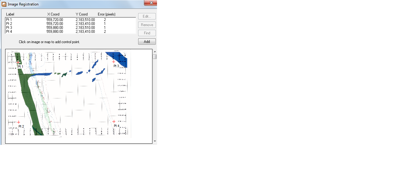
Using the smallest number of registration points allowed for a valid registration that will generate a residual, 4 points, here is an example.
Lets say you have the top-left, top-right, bottom-left and bottom-right point coordinates for your image.
Lets say the image represents a 1000m square and is 1000 pixels by 1000 pixels eg 1m pixels. This is for simplicity.
When we register we are comparing the image coordinates for these points and the ACTUAL geographic coordinates for these points and calculating the relationship.
In this ideal image if we selected these exact corners of the image and gave them each the right grid coordinate or residuals would be zero.
Please note image coordinate systems and map coordinate systems are set up differently so don't jump all over me when the following coordinates are listed. Origins for images are top-left and increase going right and down.
eg
Image Map residual(pixel error)
0,0 1000,1000 (top left) 0
1000,0 2000,1000(top right) 0
0,1000 1000,0 (bottom left) 0
1000,1000 2000,0(bottom right) 0
This is because the image is perfectly rectangular and the image coordinates selected are exactly in the corners and the geographic coordinates are exactly rectangular.
This is because the image is perfectly rectangular and the image coordinates selected are exactly in the corners and the geographic coordinates are exactly rectangular.
OK that's the perfect example.
Lets say your image, during scanning was slightly skew, maybe 2 or 3 degrees clockwise.
To get the same reference points in your image, your image will now be slightly larger, not by much, perhaps 5 or 6 pixels larger all around.
If you perform your registration as above your residuals will be zero again. This is because the geometry between the points is the same even though the image is skew.
But
If during scanning something caused the image to warp or stretch or otherwise change shape then you're going to get serious residuals and there's pretty much nothing you can do to address the issue.
If the image is warped Mapinfo has almost no way of dealing with this other than applying warping factors that often don't give great results.
A simple test it to draw a circle on an image with residuals and then remove the image from the layer list. You'll find the circle will change into an ellipse. Same with squares and rectangles. With poor image registrations these will change into parallolgrams or stretch them out without the influence of the image. This is because the image registration applies a "best fit" warp to your vector data.
The problem with scanned sources is that the scanning may have warped them or, one beauty I found, the original printing process warped the map I was scanning.
In these cases I often use open source tools like GDALwarp to apply my control to the image and create a " rubber sheeted" image that's had the scanning defects substantially removed.
Reply all
Reply to author
Forward
0 new messages