lasclip shapefile limitation
46 views
Skip to first unread message

Steeve Brissette
Mar 9, 2018, 6:38:21 AM3/9/18
to LAStools - efficient tools for LiDAR processing
Hi. I have final map sheets around a lake. I tried to clip inside the lake in order to classify the bad ground classification to unclassified like so:
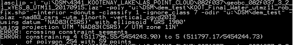
lasclip -i *_2500_sheet.laz -poly biglake.shp -interior -classify 1 -ignore_class 7 -donut -odir C:\delivery -epsg 2955 -olas
But I have an error message. Screenshot is attached. I don't understand what is going on? Is there a size limit to a lake, is the lake become a line at some point?
Thanks for your help
Steeve

Tobias K Kohoutek
Mar 9, 2018, 7:51:49 AM3/9/18
to LAStools - efficient tools for LiDAR processing
Dear Steeve,
I had sometimes similar problems using shapefiles for lastools processes in which it seems that the poligons aren't closed correctly. No idea if Martin's error message is using the same error message for those cases as well. The weird thing is, that in GIS software the same poligon appears correct but lastools seems to detect an error in the poligon which isn't visible on the screen.
Maybe Martin can give some more detail here.
Cheers,
Tobias
Steeve Brissette
Mar 9, 2018, 10:46:19 AM3/9/18
to last...@googlegroups.com
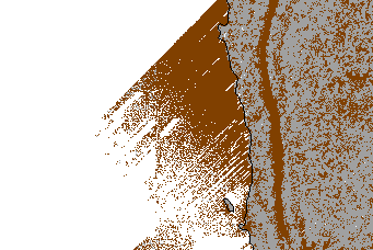
Thanks for your Reply Tobias, but I just find out the shapefile (polygon) was intersecting itself, which is a topological error, I would imagine, but I found a work around using ogr2ogr. I clip the lake to the extent of each map sheet, than I use the new shape, and everything work like a charm. I hope that can help someone…
lasclip -i *_2500_sheet.laz -poly biglake.shp -interior -classify 1 -ignore_class 7 -donut -odir C:\delivery -epsg 2955 -olas
Sincerely.
Steeve
--
Download LAStools at
http://lastools.org
http://rapidlasso.com
Be social with LAStools at
http://facebook.com/LAStools
http://twitter.com/LAStools
http://linkedin.com/groups/LAStools-4408378
Manage your settings at
http://groups.google.com/group/lastools/subscribe

Jean-François Bourdon
Mar 9, 2018, 10:59:58 AM3/9/18
to LAStools - efficient tools for LiDAR processing
I already had problems with shapefiles with lastools (shp produced by lastools I think however) and if I remember correctly the issue was with the order in which the vertices were stored in the file. The right way is in clockwise direction as you can verify with the Vertex Editor in QGIS. I know that ArcMap can correctly display a SHP with vertex in conter-clockwise direction but will fail to do any geoprocessing with it, maybe something similar is going on here...
Reply all
Reply to author
Forward
0 new messages