sample data wanted: Albers CONUS / Albers Equal Area Conic
60 views
Skip to first unread message

Martin Isenburg
May 15, 2015, 3:54:21 PM5/15/15
to LAStools - efficient command line tools for LIDAR processing
Hello,
does someone have sample LAS / LAZ data in a Albers CONUS / Albers Equal Area Conic projection such as one of those?
I would need a small tile for testing.
Thanks!
Martin @rapidlasso

Heidemann, Hans
May 29, 2015, 2:58:34 AM5/29/15
to LAStools
5072
Karl
 H. Karl Heidemann, GISP
Physical Scientist, Lidar Science
U.S. Geological Survey
Mundt Federal Building
47914 252nd Street
Sioux Falls, SD 57110
"Nothing matters very much, and very few things ... matter at all."
- Arthur James Balfour
--
Download LAStools at
http://lastools.org
http://rapidlasso.com
Be social with LAStools at
http://facebook.com/LAStools
http://twitter.com/LAStools
http://linkedin.com/groups/LAStools-4408378
Manage your settings at
http://groups.google.com/group/lastools/subscribe
Martin Isenburg
May 29, 2015, 5:33:27 AM5/29/15
to LAStools - efficient command line tools for LIDAR processing
Hello,
thanks for the sample data. Not that interesting though (a bit of the water surface of commencement bay). But it the new EPSG codes (and the Albers Equal Area Conic projection) seem to work okay:
// using EPSG 5072 directly
las2dem -i WA_PierceCo_2010_w1987n2977.laz -last_only -hillshade -opng
lasinfo -i WA_PierceCo_2010_w1987n2977.laz -odix _info -otxt
// reproject to UTM
las2las -i WA_PierceCo_2010_w1987n2977.laz -target_utm auto -odix _utm -olaz
// using reprojected UTM
las2dem -i WA_PierceCo_2010_w1987n2977_utm.laz -last_only -hillshade -opng
lasinfo -i WA_PierceCo_2010_w1987n2977_utm.laz -odix _info -otxt
Regards,
Martin @rapidlasso
PS: Looks like I need to make sure that when reprojection las2las will *delete* the then out-of-date LAStiling information from the LAS header ...
Martin Isenburg
May 29, 2015, 6:00:18 AM5/29/15
to LAStools - efficient command line tools for LIDAR processing
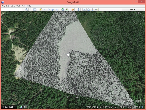
Hello again.
offline Karl had send me a larger LAZ file with about half a million points that already has the ESPG code 5072 in its GeoTIFF tags.
las2dem -i EPSG-5072_Sample.laz -last_only -hillshade -opng
the resulting geo-referenced KML embedded PNG seems reasonably well aligned with Google Earth imagery (see attached pic). Nevertheless we use las2las to set (*only* set. this does not reproject) the EPSG key to 5072 via the GeoTIFF tags
las2las -i EPSG-5072_Sample.laz -epsg 5072 -odix _5072 -olaz
and look at the new GeoTIFF tags with lasinfo
lasinfo -i EPSG-5072_Sample_5072.laz
reporting all LAS header entries:
file signature: 'LASF'
file source ID: 0
global_encoding: 0
project ID GUID data 1-4: 905441C8-9857-4AB7-62A2-F970E8D1D7D2
version major.minor: 1.2
system identifier: 'LAStools (c) by rapidlasso GmbH'
generating software: 'las2las (version 150516)'
file creation day/year: 55/2012
header size: 227
offset to point data: 1085
number var. length records: 2
point data format: 1
point data record length: 28
number of point records: 448566
number of points by return: 369493 72679 6196 198 0
scale factor x y z: 0.01 0.01 0.01
offset x y z: 0 0 0
min x y z: 2128000.00 2711000.00 28.21
max x y z: 2128568.03 2711760.39 87.18
variable length header record 1 of 2:
reserved 43707
user ID 'LASF_Projection'
record ID 34735
length after header 40
description 'by LAStools of rapidlasso GmbH'
GeoKeyDirectoryTag version 1.1.0 number of keys 4
key 1024 tiff_tag_location 0 count 1 value_offset 1 - GTModelTypeGeoKey: ModelTypeProjected
key 3072 tiff_tag_location 0 count 1 value_offset 5072 - ProjectedCSTypeGeoKey: NAD83(NSRS2007) / Conus Albers
key 3076 tiff_tag_location 0 count 1 value_offset 9001 - ProjLinearUnitsGeoKey: Linear_Meter
key 4099 tiff_tag_location 0 count 1 value_offset 9001 - VerticalUnitsGeoKey: Linear_Meter
variable length header record 2 of 2:
reserved 43707
user ID 'liblas'
record ID 2112
length after header 710
description 'OGR variant of OpenGIS WKT SRS'
LASzip compression (version 2.3r0 c2 50000): POINT10 2 GPSTIME11 2
LAStiling (idx 9591, lvl 7, sub 0, bbox 2.065e+006 2.642e+006 2.193e+006 2.77e+006)
reporting minimum and maximum for all LAS point record entries ...
X 212800000 212856803
Y 271100000 271176039
Z 2821 8718
intensity 0 255
return_number 1 4
number_of_returns 1 4
edge_of_flight_line 0 1
scan_direction_flag 0 1
classification 1 18
scan_angle_rank -3 23
user_data 198 255
point_source_ID 811 812
gps_time -26285365.622809 -26284922.939496
WARNING: range violates GPS week time specified by global encoding bit 0
overview over number of returns of given pulse: 297200 132611 17965 790 0 0 0
histogram of classification of points:
193899 unclassified (1)
58853 ground (2)
161 noise (7)
332 road surface (11)
159141 bridge deck (17)
36180 Reserved for ASPRS Definition (18)
Regards,
Martin @rapidlasso
Reply all
Reply to author
Forward
0 new messages