DEMzip - first independent compression results are in

Martin Isenburg
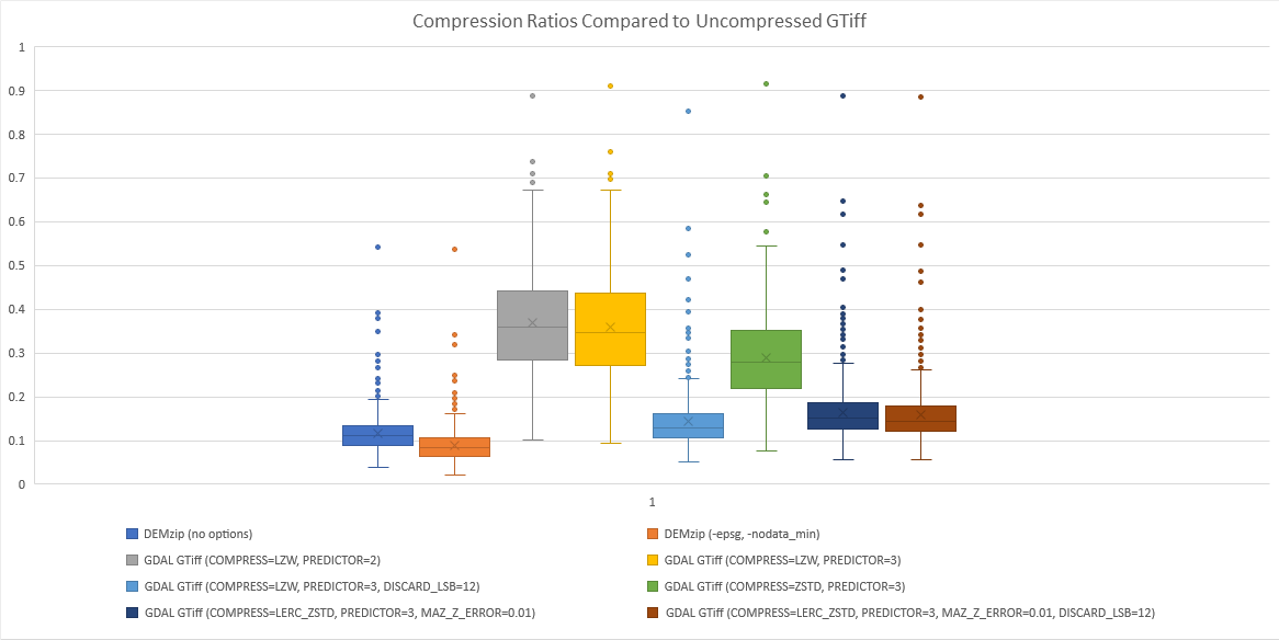
Compression Scheme | Median Compression Ratio |
DEMzip (no options) | 11.0% |
DEMzip (-epsg, -nodata_min) | 8.4% |
GDAL GTiff (COMPRESS=LZW, PREDICTOR=2) | 34.5% |
GDAL GTiff (COMPRESS=LZW, PREDICTOR=3) | 36.0% |
GDAL GTiff (COMPRESS=LZW, PREDICTOR=3, DISCARD_LSB=12) | 13.0% |
GDAL GTiff (COMPRESS=ZSTD, PREDICTOR=3) | 27.8% |
GDAL GTiff (COMPRESS=LERC_ZSTD, PREDICTOR=3, MAZ_Z_ERROR=0.01) | 15.1% |
GDAL GTiff (COMPRESS=LERC_ZSTD, PREDICTOR=3, MAZ_Z_ERROR=0.01, DISCARD_LSB=12) | 14.5% |
He writes that "the only compressor that occasionally beats DEMzip is the very dangerous “only use if you know what you’re doing” LZW with predictor 3 and discarding the least significant 12 bits, which also produces somewhat unreliable results (I only guessed at the 12 bits instead of actually thinking about it). So DEMzip with NODATA removal is by far the best compression tested."
Thank you, Nathanael, for these excellent experiments.
Martin

Brent Edwards
-scale [src_min src_max [dst_min dst_max]]Martin Isenburg
The typical use would be for DEM, DTM, DSM, CHM, metrics, and GEOID difference rasters.
usage:
demzip -i dem.tif -o dem.laz
demzip -i dem.laz -o dem.tif
demzip -i dem.bil -o dem.laz
demzip -i dem.laz -o dem.bil
demzip -i dem.asc -o dem.laz
demzip -i dem.laz -o dem.asc
demzip -i dem\*.tif -olaz -cores 3
demzip -i dem\*.bil -olaz -cores 3
demzip -i dem\*.asc -olaz -cores 3
demzip -i dem\*.laz -otif -cores 3
demzip -i dem\*.laz -obil -cores 3
demzip -i dem\*.laz -oasc -cores 3
demzip -i dem\*.asc -odir compressed_dem -olaz -cores 2
demzip -i compressed_dem\*.laz -odir dem -oasc -cores 2
demzip -h
other options:
-nodata_value -9999 : raster value -9999 considered nodata
-nodata_min -1000 : raster values -1000 or below considered nodata
-nodata_min 32768 : raster values 32768 or above considered nodata
-scale 1.0 : set vertical resolution to meter (or feet)
-scale 0.1 : set vertical resolution to decimeter (or decifeet)
-scale 0.01 : set vertical resolution to centimeter (or centifeet)
-longlat -wgs84 : set horizontal datum to longlat on WGS84
-longlat -etrs89 : set horizontal datum to longlat on ETRS89
-longlat -gda94 : set horizontal datum to longlat on GDA94
-longlat -nad83 : set horizontal datum to longlat on NAD83
-longlat -nad83_csrs : set horizontal datum to longlat on NAD83(CSRS)
-longlat -nad83_2011 : set horizontal datum to longlat on NAD83(2001)
-longlat -nad83_harn : set horizontal datum to longlat on NAD83(HARN)
-utm 32north -wgs84 : set horizontal datum to UTM32 north on WGS84
-epsg 27700 : set horizontal datum to EPSG code 27700
-vertical_wgs84 : set vertical datum to WGS84
-vertical_navd88 : set vertical datum to NAVD88
-vertical_cgvd2013 : set vertical datum to CGVD2013
-vertical_nn2000 : set vertical datum to NN2000
-vertical_dhhn92 : set vertical datum to DHHN92
-vertical_dhhn2016 : set vertical datum to DHHN2016
-elevation_survey_feet : set vertical units from meters to US survey feet
-sigmaxy 0.5 : horizontal accuracy expected at 0.5 meters (inactive)