Restrict Access to National LiDAR??? It ain't worth it!!!
226 views
Skip to first unread message

Martin Isenburg
Dec 1, 2014, 2:20:24 AM12/1/14
to LAStools - efficient command line tools for LIDAR processing
Hello,
policy makers in many countries are debating whether to open their National LiDAR holdings - collected with tax-payer money - for free access or whether they should sell this data to recoup expenses to finance the next survey.
Someone made a "Freedom of Information" request to the "Environment Agency" which are collecting, processing, and selling LiDAR data and products for England.
"Dear Environment Agency, Please could you provide me with a breakdown by year of all revenue made from the sale of LiDAR Data? Yours faithfully, Louise Huby"
The answer: Revenue from LiDAR sales is shockingly low. Read the full story here:
Regards,
Martin @rapidlasso
Martin Isenburg
Dec 2, 2014, 9:59:22 AM12/2/14
to LAStools - efficient command line tools for LIDAR processing
Hello,
Received a great follow up by Fabrizio Tadina who writes:
I agree, the open access to all the geospatial national data generates within 5 years more indirect revenue for the country than keeping it locked up and inaccessible [...] look at the Danish concept and figures:
Regards,
Martin
Message has been deleted
Message has been deleted
Martin Isenburg
Jun 16, 2015, 10:32:55 AM6/16/15
to LAStools - efficient command line tools for LIDAR processing
Hello,
"[...] By making the LIDAR data open to all, users will be able to access it free of charge, even for commercial use. We hope that by removing any cost barriers, our data will improve the quality of flood risk modelling used by businesses and local communities and allow for the development of innovative tools and techniques to further benefit the environment. [...]"
Great news bulletin [1] from the Environment Agency in England titled
Opening up our LIDAR data
that essentially states that all LIDAR is to become Open Data on 1 September. You may remember our blog post arguing that it makes no financial (or any other) sense for a national agency to sell geospatial data in an attampt to recoup the collection costs:
And yes, all open *including* commercial use as it states in the corresponding blog article [2]:
"[...] By making the LIDAR data open to all, users will be able to access it free of charge, even for commercial use. We hope that by removing any cost barriers, our data will improve the quality of flood risk modelling used by businesses and local communities and allow for the development of innovative tools and techniques to further benefit the environment. [...]"
Woot. Woot. England joins the "hip" and innovative club of Europe countries with "open national LiDAR" that currently consists of Finland, Holland, Denmark, Spain, and ... ?
Too bad in my native Germany we still live in dark LiDAR caves ... (-;
Regards,
Martin @rapidlasso
Martin Isenburg
Sep 1, 2015, 4:58:29 PM9/1/15
to LAStools - efficient tools for LiDAR processing
Hello,
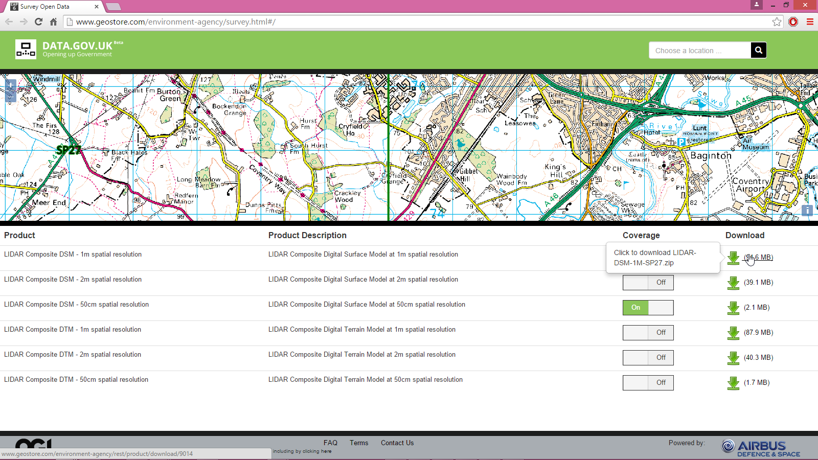
it seems that the UK "LiDAR data" is now open. Attached is a screenshot from the download site. It looks good but there still seem to be a few hick-ups with the server because all the ZIP files that I have been trying to download so far had zero bytes in size. Maybe server overload ... (-: ... But it's also a bit odd why the 50cm DTM and DSM rasters are reported to be much much smaller in size than the 1m or 2m raster products. See attached screenshot or try for yourself here:
However ... given all my excitement back on June 16th about the news by the Environment Agency about releasing all of the LiDAR data from England there appears to be one big downer. It seems that the actual LiDAR data (meaning the point cloud) is not part of this open data release. The only thing released so far are derivative raster products: DTM and DSM rasters in three resolutions: 50 cm, 1 m, and 2m. That is already great for many folks but not for us here in the LAStools user forum ... \-:
Regards,
Martin @rapidlasso

Terje Mathisen
Sep 2, 2015, 2:14:46 AM9/2/15
to last...@googlegroups.com
Martin Isenburg wrote:
> Hello,
>
> it seems that the UK "LiDAR data" is now open. Attached is a
> screenshot from the download site. It looks good but there still seem
> to be a few hick-ups with the server because all the ZIP files that I
> have been trying to download so far had zero bytes in size. Maybe
> server overload ... (-: ... But it's also a bit odd why the 50cm DTM
> and DSM rasters are reported to be much much smaller in size than the
> 1m or 2m raster products. See attached screenshot or try for yourself
> here:
This is similar to the initial Swiss approach, only ground and
> Hello,
>
> it seems that the UK "LiDAR data" is now open. Attached is a
> screenshot from the download site. It looks good but there still seem
> to be a few hick-ups with the server because all the ZIP files that I
> have been trying to download so far had zero bytes in size. Maybe
> server overload ... (-: ... But it's also a bit odd why the 50cm DTM
> and DSM rasters are reported to be much much smaller in size than the
> 1m or 2m raster products. See attached screenshot or try for yourself
> here:
vegetation surface rasters were available, all the rest of the scanning
data got thrown away!
About a year or two ago they realized that this was really stupid and
all new scans are saving the raw data.
In the meantime it has definitely hindered their national mapping
industry, i.e. OCAD.COM is the Swiss developer of the sw used for pretty
much all orienteering mapping worldwide, as well as lots of national
mapping agencies, and it has native methods for processing DTM & DSM
rasters but the only LiDAR capability is to read in LAS files and
convert them to either a DTM or a DSM. They can also subtract one from
the other to come up with a vegetation height model.
Now, with national point clouds they are looking at how much more data
they can extract from the raw point cloud. :-)
Terje
>
> http://www.geostore.com/environment-agency/survey.html#/
>
> However ... given all my excitement back on June 16th about the news
> by the Environment Agency about releasing all of the LiDAR data from
> England there appears to be one big downer. It seems that the actual
> LiDAR data (meaning the point cloud) is not part of this open data
> release. The only thing released so far are derivative raster
> products: DTM and DSM rasters in three resolutions: 50 cm, 1 m, and
> 2m. That is already great for many folks but not for us here in the
> LAStools user forum  ...  \-:
> http://www.geostore.com/environment-agency/survey.html#/
>
> However ... given all my excitement back on June 16th about the news
> by the Environment Agency about releasing all of the LiDAR data from
> England there appears to be one big downer. It seems that the actual
> LiDAR data (meaning the point cloud) is not part of this open data
> release. The only thing released so far are derivative raster
> products: DTM and DSM rasters in three resolutions: 50 cm, 1 m, and
> 2m. That is already great for many folks but not for us here in the
> http://us6.campaign-archive1.com/?u=e7311d49e9ac144a359ee2a96&id=99993214be
> <http://us6.campaign-archive1.com/?u=e7311d49e9ac144a359ee2a96&id=99993214be>
> [2]Â
> http://environmentagency.blog.gov.uk/2015/06/16/free-mapping-data-will-elevate-flood-risk-knowledge/
> <http://environmentagency.blog.gov.uk/2015/06/16/free-mapping-data-will-elevate-flood-risk-knowledge/>
>
>
>
> On Tue, Dec 2, 2014 at 3:58 PM, Martin Isenburg
> <martin....@gmail.com <mailto:martin....@gmail.com>> wrote:
>
> Hello,
>
> Received a great follow up by Fabrizio Tadina who writes:
>
> I agree, the open access to all the geospatial national data
> generates within 5 years more indirect revenue for the country
> than keeping it locked up and inaccessible [...] look at the
> Danish concept and figures:
>
> http://www.digst.dk/Home/Servicemenu/English/Digitisation/~/media/Files/English/Fact_sheet_BasicData_pdf.ashx
> <http://www.digst.dk/Home/Servicemenu/English/Digitisation/%7E/media/Files/English/Fact_sheet_BasicData_pdf.ashx>
>
>
>
> On Tue, Dec 2, 2014 at 3:58 PM, Martin Isenburg
> <martin....@gmail.com <mailto:martin....@gmail.com>> wrote:
>
> Hello,
>
> Received a great follow up by Fabrizio Tadina who writes:
>
> I agree, the open access to all the geospatial national data
> generates within 5 years more indirect revenue for the country
> than keeping it locked up and inaccessible [...] look at the
> Danish concept and figures:
>
> http://www.digst.dk/Home/Servicemenu/English/Digitisation/~/media/Files/English/Fact_sheet_BasicData_pdf.ashx
>
> Regards,
>
> Martin
>
> On Dec 1, 2014 2:18 PM, "Martin Isenburg"
> <martin....@gmail.com <mailto:martin....@gmail.com>>
> Regards,
>
> Martin
>
> On Dec 1, 2014 2:18 PM, "Martin Isenburg"
> wrote:
>
> Hello,
>
> policy makers in many countries are debating whether to
> open their National LiDAR holdings - collected with
> tax-payer money - for free access or whether they should
> sell this data to recoup expenses to finance the next survey.
>
> Someone made a "Freedom of Information" request to the
> "Environment Agency" which are collecting, processing, and
> selling LiDAR data and products for England.
>
> "Dear Environment Agency, Please could you provide me with
> a breakdown by year of all revenue made from the sale of
>
> Hello,
>
> policy makers in many countries are debating whether to
> open their National LiDAR holdings - collected with
> tax-payer money - for free access or whether they should
> sell this data to recoup expenses to finance the next survey.
>
> Someone made a "Freedom of Information" request to the
> "Environment Agency" which are collecting, processing, and
> selling LiDAR data and products for England.
>
> "Dear Environment Agency, Please could you provide me with
> LiDAR Data? Yours faithfully, Louise Huby"
>
> The answer: Revenue from LiDAR sales is shockingly low.
> Read the full story here:
>
> http://rapidlasso.com/2014/11/30/restricting-access-to-national-lidar-is-it-worth-it/
> <http://rapidlasso.com/2014/11/30/restricting-access-to-national-lidar-is-it-worth-it/>
>
> Regards,
>
> Martin @rapidlasso
>
>
> --
>
> The answer: Revenue from LiDAR sales is shockingly low.
> Read the full story here:
>
> http://rapidlasso.com/2014/11/30/restricting-access-to-national-lidar-is-it-worth-it/
> <http://rapidlasso.com/2014/11/30/restricting-access-to-national-lidar-is-it-worth-it/>
>
> Regards,
>
> Martin @rapidlasso
>
>
> Download LAStools at
> http://lastools.org
> http://rapidlasso.com
> Be social with LAStools at
> http://facebook.com/LAStools
> http://twitter.com/LAStools
> http://linkedin.com/groups/LAStools-4408378
> Manage your settings at
> http://groups.google.com/group/lastools/subscribe
--
- <Terje.M...@tmsw.no>
"almost all programming can be viewed as an exercise in caching"
Martin Isenburg
Sep 22, 2015, 9:56:01 AM9/22/15
to LAStools - efficient command line tools for LIDAR processing
Hello,
great news!!! The anticipated domino-effect of England's opening of their national LiDAR seems to have started. According to a tweet by @NatResWales that was retweeted by @EnvAgencyGeomat the government of Wales will also open their own national LiDAR data holdings soon:
http://twitter.com/EnvAgencyGeomat/status/646308933234200576
http://twitter.com/EnvAgencyGeomat/status/646308933234200576
Germany, Austria, France, Poland ... stop living in the darkages of closed data containters. We paid for that LiDAR. Restricting access to it won't help paying for updating it [1]. So please open it already as long as its "cool" to do so ... (-:
Martin
Martin
Martin Isenburg
Jan 2, 2016, 11:45:08 AM1/2/16
to LAStools - efficient command line tools for LIDAR processing
Hello,
This discovery of 2000 year old roads in the UK by amateur archaeologists [1] makes another great story about the potential for discovery and innovation when government agencies - in this case England - open up their geospatial data containers to the tax-paying public (who financed the data collect in the first place). It ca also be viewed as yet another showcase of how restricting access to national LiDAR hinders a nation to get the highest possible return on the investment for its citizens [2].
But so far this message has fallen on deaf ears in my native Germany as well as in other European countries. A prime candidate for implementing the next European open LiDAR portal would probably be Poland. According to what I have heard, the Polish government has recently conducted a national LiDAR survey of very high-resolution (8 pulses/m^2 in cities and 4 pulses/m^2 in the countryside). Apparently 85 % of the cost was subsidized with EU funding. So if that data was paid for by tax payers all across the European Union then please give us access so we can all, for example, find tanks in polish forests [3] or locate old German bunkers under the canopy [4] ... (-:
Regards,
Martin @rapidlasso
Reply all
Reply to author
Forward
0 new messages