how to use project GUID of LAS header?

Martin Isenburg
A proprietary format is a file format of a company, organization, or individual
- that contains data that is ordered and stored according to a particular encoding-scheme, designed by the company or organization to be secret, such that the decoding and interpretation of this stored data is only easily accomplished with particular software or hardware that the company itself has developed. The specification of the data encoding format is not released, or underlies non-disclosure agreements.
In contrast an open format is a file format that is published and free to be used by everybody.

Evon Silvia
--
--
You are subscribed to "The LAS room - a friendly place to discuss the the LAS or LAZ formats" for those who want to see LAS or LAZ succeed as open standards. Go on record with bug reports, suggestions, and concerns about current and proposed specifications.
Visit this group at http://groups.google.com/group/lasroom
Post to this group with an email to las...@googlegroups.com
Unsubscribe by email to lasroom+u...@googlegroups.com
---
You received this message because you are subscribed to the Google Groups "The LAS room - a friendly place to discuss the LAS and LAZ formats" group.
To unsubscribe from this group and stop receiving emails from it, send an email to lasroom+u...@googlegroups.com.
For more options, visit https://groups.google.com/d/optout.

Lewis Graham
The GUID is infinitely useful.
It is guaranteed to be unique across the universe of all GUIDs.
You can generate one using any of a number of on-line GUID generators.
Remember, no one need know anything at all about the GUID so long as the same GUID is used for all files in a project.
Thus if a GUID is properly assigned to a project, all data within that project (all the way down to single points) can be uniquely identified.
Lewis Graham
Evon Silvia
--
Download LAStools at
http://lastools.org
http://rapidlasso.com
Be social with LAStools at
http://facebook.com/LAStools
http://twitter.com/LAStools
http://linkedin.com/groups/LAStools-4408378
Manage your settings at
http://groups.google.com/group/lastools/subscribe
Jan Depner
Exactly *how* is it guaranteed to be unique across the universe of all GUIDs. The implied question in the original post was, "where is the centralized system to lookup or assign globally-unique GUIDs". Please explain how a GUID is, to quote you, "properly assigned to a project". I can inadvertently (or on purpose for that matter) create a duplicate of any GUID that exists in any LAS file, therefore, it is *not* guaranteed to be unique across the universe of all GUIDs. Please explain how we can make sure that we aren't using something that was previously used by some other project. Can you provide a central clearing house for GUIDs? Can *anyone* provide a central clearing house for GUIDs? If so we would all like to know about it. I'd love to be able to label every file I create as USACE JALBTCX or Naval Oceanographic Office JALBTCX or NOAA JALBTCX but I don't know if I'll be duplicating something that already exists. The definition in the LAS v.1.4 specification is woefully inadequate.
V/r,
Jan Depner
--
Lewis Graham
GUIDs are unique by construction – that’s the entire purpose of the invention of GUIDs. They solve the problem of uniqueness without the need for centralized arbitration.
If you create a GUID (using a proper GUID generator which, again, does not require a lookup of precreated GUIDs), the chances of creating a duplicate are less than the chance you get hit in the head by a meteorite.
We envisioned these as being used (in LAS) for managing data while still “near” the sensor. For example, I could tag a bunch of LAS files that came from the same sortie with a GUID and then tag the related metadata (such as the trajectory) with that same GUID. It is an optional field in the LAS header and can be freely used for project management schemes.
We did not envision the GUID as being particularly useful once data hit the exploitation phase (for example, a county government taking delivery of some LAS data). Once you have merged, at the tile level, a bunch of individual LAS files, the individual point tracking requires a local catalog (which can be stored in a VLR of the LAS file). I am not aware of any implementations of this.
Thus the GUID is primarily used in production management. It is particularly useful in multi-sensor, multi-contractor projects.
Regards,
Lewis
Lewis Graham
Terje Mathisen
>
> Hi Jan,
>
> GUIDs are unique by construction – that’s the entire purpose of the
> invention of GUIDs. They solve the problem of uniqueness without the
> need for centralized arbitration.
>
> If you create a GUID (using a proper GUID generator which, again, does
> not require a lookup of precreated GUIDs), the chances of creating a
> duplicate are less than the chance you get hit in the head by a
> meteorite.
>
With 2^128 possible values, the Birthday paradox states that you need to
produce approximately 2^64 of them (in a single usage domain) before you
get the _first_ duplicate, i.e. since the surface area of the Earth is
about 5.1e8 sq km we need an average of 36170 surveys per square meter,
each with its own randomly generated GUID, before we can expect the
first collision.
BTW, those numbers include all the oceans; if we limit ourselves to land
surveys we get about 250 000 GUIDs per square meter or one for every 2x2
mm spot on the planet.
Even if you reserve part of the space for a vendor or application ID
string, most of that calculation will still hold. :-)
Terje
--
- <Terje.M...@tmsw.no>
"almost all programming can be viewed as an exercise in caching"
Jan Depner
Now the next question is - where can I get a proper GUID generator ;-) Is there one in LASlib?
The second point though is covered here - http://news.nationalgeographic.com/news/2013/02/130220-russia-meteorite-ann-hodges-science-space-hit/
Cheers,
Jan
Lewis Graham
Here is an on-line generator:
Second part – she must have duplicated a doppelganger’s GUID…..
Regards,
Lewis
Lewis Graham
AirGon LLC, small UAS Solutions
GeoCue Group
9668 Madison Blvd., Suite 202
Madison, AL USA 35758
01-256-461-8289
Terje Mathisen
> Thanks Lewis,
>
> Now the next question is - where can I get a proper GUID generator
> ;-) Is there one in LASlib?
Linux and most of the other unix derivatives have something like
/dev/random which combines a true random number generator (collecting
entropy from all available sources, including mouse and kbd
interactions, packet arrival times and any cpu hw source.
What kind of cpu hardware?
On a reasonably modern INtel chip you have the RDRAND instruction which
returns true hw random values of up to 64 bits:
Call it twice (checking the carry flag each time to verify that data was
available) and you have the 128 bits needed.
BTW, the minimum code needed to use this instruction requires either
inline asm or compiler intrinsics, you should first check that the
RDRAND opcode is available, which you do with the following code:
if (cpuid(0,abcd) >= 1 && (cpuid(1,abcd)) && (abcd[2] >> 30) & 1) {
// Safe to read the RDRAND register!
I can code up a minimal-size Win32 application to do just this, it
should be _very_ tiny! :-)
Terje
>
> The second point though is covered here -
> http://news.nationalgeographic.com/news/2013/02/130220-russia-meteorite-ann-hodges-science-space-hit/
obviously significantly larger than those for accidentally getting
duplicate GUIDs. :-)
Terje
>> *On Behalf Of *Jan Depner
>> *Sent:* Monday, May 11, 2015 21:24
>> *To:* last...@googlegroups.com
>> *Subject:* Re: [LAStools] RE: [The LAS room] how to use project GUID
>> [mailto:las...@googlegroups.com] *On Behalf Of *Evon Silvia
>> *Sent:* Monday, May 11, 2015 10:38
>> *To:* las...@googlegroups.com <mailto:las...@googlegroups.com>
>> *Cc:* LAStools - efficient command line tools for LIDAR processing
>> *Subject:* Re: [The LAS room] how to use project GUID of LAS header?
>> <http://en.wikipedia.org/wiki/File_format> of a company,
>>
>> ·that contains data that is ordered and stored according to a
>> particular encoding-scheme, designed by the company or
>> organization to be secret, such that the decoding and
>> company itself has developed. The specification of the data
>> encoding format is not released, or underlies non-disclosure
>> agreements
>> In contrast an open format
>>
>>
>> [1] http://en.wikipedia.org/wiki/Proprietary_format
>>
>> --
>> --
>> You are subscribed to "The LAS room - a friendly place to
>> discuss the the LAS or LAZ formats" for those who want to see
>> LAS or LAZ succeed as open standards. Go on record with bug
>> reports, suggestions, and concerns about current and proposed
>> specifications.
>>
>> Visit this group at http://groups.google.com/group/lasroom
>> <http://groups.google.com/group/lasroom>
>> Post to this group with an email to las...@googlegroups.com
>> You received this message because you are subscribed to the
>> Google Groups "The LAS room - a friendly place to discuss the
>> LAS and LAZ formats" group.
>> To unsubscribe from this group and stop receiving emails from
>> it, send an email to lasroom+u...@googlegroups.com
>> --
>> --
>> You are subscribed to "The LAS room - a friendly place to discuss
>> the the LAS or LAZ formats" for those who want to see LAS or LAZ
>> succeed as open standards. Go on record with bug reports,
>> suggestions, and concerns about current and proposed specifications.
>>
>> Visit this group at http://groups.google.com/group/lasroom
>> Post to this group with an email to las...@googlegroups.com
>> You received this message because you are subscribed to the
>> Google Groups "The LAS room - a friendly place to discuss the LAS
>> and LAZ formats" group.
>> To unsubscribe from this group and stop receiving emails from it,
>> send an email to lasroom+u...@googlegroups.com

Malcolm Williamson
http://en.wikipedia.org/wiki/Universally_unique_identifier for an
overview. These are particularly useful in enterprise-level GIS
databases to support check-out/check-in editing and synchronization
capabilities.
-Malcolm

Dennis Shimer
https://stackoverflow.com/questions/16372433/linux-command-to-generate-new-guid/21191302#21191302
import uuid
print str(uuid.uuid1())
python new_uuid.py
c83a0330-f8bd-11e4-b7fa-001ec9404dd1

Ramesh Sridharan
Regards,
Jan Depner
Martin Isenburg

Andrew Bell
Hello,
okay. I am adding an option to lasinfo called '-set_GUID' that takes in a hexastring. That said, there is still an issue with endian-ness. The GUIDs seem to be defined as big endian [1] but the LAS specification states all fields are little endian [2]. Hence, I am not even sure the current way these strings are reported by lasinfo has been correct all these years.Are all GUIDs reported by lasinfo in the wrong byte order? I am admittingly much more knowledgable about grilling SQUIDs than being grilled over GUIDs ... (-;
andrew....@gmail.com
Martin Isenburg
--

tjorda01
Evon Silvia
I, too, am interested to know how LAStools, LP360, TerraSolid, GeoCue, and similar tools implement this.Also added lasroom back to this email chain.Evon
Evon Silvia
Lewis Graham
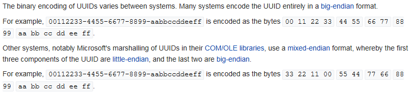
After a close read of the spec, I'm getting the impression that it was originally intended to follow with the Microsoft-style of UUIDs, as described on the Wikipedia page.
<image.png>

Tom Jordan
Evon Silvia
lasinfo -i myfile.las -set_GUID F794F8A4-A23E-421E-794D-725031306A6F