las2las: get_ProjectedCSTypeGeoKey error
47 views
Skip to first unread message

Max Musterman
May 18, 2018, 8:29:10 AM5/18/18
to LAStools - efficient tools for LiDAR processing
Hi all,
Need to store projection in files!
I have a set of LiDAR las or laz files. Some have the projection stored others do not. From the metadata file I know the projection should be GDA94 / MGA zone 56.
I have tried to use las2las to store the projection info with the las or laz files.
Script was as fo
llows:::batch script for copy of las to laz format
set PATH=%PATH%;C:\lastools\bin;
::set variables
set HOMETEMP=H:\Corporate1\LAS\LPMA\2010103_Wooli
set OUTPUT_LAZ=%HOMETEMP%\LAZ
set OUTPUT_BOUND=%HOMETEMP%\Boundaries
:: or 55south
set WGS=utm 56south
set NUM_CORES=12
::Change Projection, make laz
las2las -i %HOMETEMP%\LAZ\*.laz ^
-cores %NUM_CORES% ^
-gda94 ^
-%WGS% ^
-elevation_meter ^
-vertical_wgs84^
-olaz -odir %OUTPUT_LAZ%\
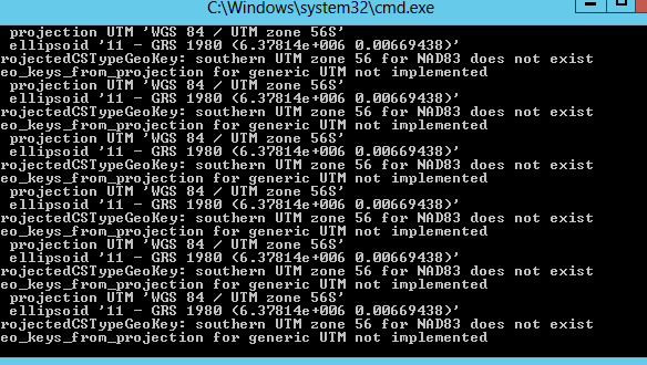
I have attached a screen shot of the cmd.Would appreciate any thoughts shared on this!!!Thanks!

Martin Isenburg
May 18, 2018, 9:52:10 AM5/18/18
to LAStools - efficient command line tools for LIDAR processing
Hello,
there's some special handling built into LAStools so that reading an auxiliary file from disk can be avoided for common projections such as NAD83 and UTM combinations but it looks like the special UTM /
MGA /
GDA94
case for Australia is treated about as poorly as immigrants on Christmas Island ... I've got to fix that code segment. Until then you could simply specify the correct EPSG code directly:
Hence replace all this:
-gda94 ^
-utm 56south ^
-elevation_meter ^
with
-epsg 28356
^
Regards,
Martin @rapidlasso
--
Download LAStools at
http://lastools.org
http://rapidlasso.com
Be social with LAStools at
http://facebook.com/LAStools
http://twitter.com/LAStools
http://linkedin.com/groups/LAStools-4408378
Manage your settings at
http://groups.google.com/group/lastools/subscribe
Max Musterman
May 20, 2018, 6:38:55 PM5/20/18
to LAStools - efficient tools for LiDAR processing
Awesome! Worked like a charm!
Thanks for that!!!
Martin Isenburg
May 20, 2018, 10:08:45 PM5/20/18
to LAStools - efficient command line tools for LIDAR processing
Hello,
in the meantime LAStools was also updated to correctly handle your previous command line. Download the latest version (180520) that also have these changes below:
20 May 2018 -- LASlib, all LAStools: bug fix when trying to set CRS via '-gda94 -utm 56south' in command line
19 May 2018 -- lasnoise, lasheight, & others: bug fix when on-the-fly filtering on additional attributes
12 May 2018 -- las2las, LASlib: new filters '-drop_RGB_red 5000 6000' and '-drop_RGB_green 200 10000'
8 May 2018 -- las2las: handling of OGC WKT and more clear "setting" versus "reprojecting" the CRS
29 April 2018 -- all LAStools GUIs: allow to overlay a PNG assuming it has a world-coordinate PGW file
23 April 2018 -- lasview: for manual editing also "<r>egister changes" avaulable via pop-up menu
22 April 2018 -- lasview: also display 'user data' attribute for points picked with 'i'
21 April 2018 -- lasgrid, las2dem, lascanopy: fix bug of removed filters/transforms when gridding/rasterizing '-attribute ...'
Regards,
Martin @rapidlasso
Reply all
Reply to author
Forward
0 new messages