lascontrol for horizontal accuracy check
289 views
Skip to first unread message

Tobias K Kohoutek
Mar 6, 2017, 2:59:11 PM3/6/17
to LAStools - efficient tools for LiDAR processing
Dear Martin,
is there any possibility that you add horizontal accuracy check to lascontrol or add a second lascontrol_hor?
I'm asking because horizontal and vertical accuracy are values given by the LiDAR manufacturers which do not fulfill all project scales. For example our Trimble Harrier 68i System's horizontal accuracy doesn't fulfill the accuracy limit of scales smaller than 1:1000. So for project scales of 1:500 the point cloud has to be checked and probably needs an adjustment.
Until now lascontrol is made to check ground and/or model points against a *.csv file including GCP's. People who don't use lascontrol most likely follow the ASPRS advice and compare every single GCP with the closest point (Euclidean distance) of the point cloud. which represents the ground. Here lascontrol definitely is the better solution by comparing the height of the GCP with the TIN.
By checking ASPRS guidelines, there's a similar setup for horizontal accuracy reporting in which RMSE for X and Y are calculated also from a GCP towards the closest point of the point cloud.
However, I think it's clear that, as long as you don't have a real dense point cloud, it's impossible to represent this GCP with one point of the cloud.
So here comes now what we would ask to implement in LAStools. From terrestrial laser scanning the fitting of form primitives is well known. From the beginning cyclinders and spheres have been used to register scans. Our idea is to use polygons, which corners are measured GCP's and check those polygons against the cloud. For example the 4 corners of a roof a measured with GNSS. Mostly the coordinate is reduced to the ground by pole height but this doesn't matter in our idea. Here the polygon would be constructed only by X and Y coordinates of those 4 corner points and all classified building points have to lay inside this polygon. The amount of points which actually are inside the polygon, checked with "lascontrol_hor" should be a percentile value, which should be higher than 95% to fulfill horizontal accuracy. Something similar can be realized by using GIS software and "count the number of point features within a polygon" and then calculate their percentile value. Kang and Li's publication Primitive Fitting Based on the Efficient multiBaySAC Algorithm is what I'm looking for to implement in lascontrol_hor for simple primitives like 2D polygons. I'll repeat the Z value doesn't matter in the case of classified roof tops when the measurement is reduced to the bare ground. (If a bridge deck is measured of course X, Y and Z can be checked at the same time.)
Another possibility would be like it is solved in open source software GeoRegression and its Transform Fitting by comparing the classified points of the ALS cloud and a generated point cloud from the GCP-polygon. Or vice versa, compare the GCP-polygon with a polygon created out of the classified points of the point cloud.
If anybody knows how I can check horizontal accuracy of a ALS point cloud already in LAStools I'm really hapy if you can point me in the right direction.
Cheers,
Tobias

Sampath (CTR), Aparajithan
Mar 9, 2017, 9:53:16 AM3/9/17
to last...@googlegroups.com
Hi
Regards
If you are interested in measuring "relative" inter swath horizontal accuracy, you could download the software here : (https://edcftp.cr.usgs.gov/project/rst/DQM/),
The software requires lidar swath data in the ASPRS LAS (or the LAZ) format.
You would require python with numpy ans scipy to run the python scripts, call the windows executables and analyze the output
Ajit
Aparajithan Sampath, PhD
Stinger Ghaffarian Technologies, Inc. (SGT)
Contractor to the U.S. Geological Survey (USGS)
Earth Resources Observation and Science (EROS) Center
47914 252nd Street
Sioux Falls, SD 57198
Phone: 605-594-6102
Fax: 605-594-2828
NOTE - E-mail address change as of April 4, 2016. Please update your contact list accordingly!
--
Download LAStools at
http://lastools.org
http://rapidlasso.com
Be social with LAStools at
http://facebook.com/LAStools
http://twitter.com/LAStools
http://linkedin.com/groups/LAStools-4408378
Manage your settings at
http://groups.google.com/group/lastools/subscribe
Tobias K Kohoutek
Mar 9, 2017, 3:49:24 PM3/9/17
to LAStools - efficient tools for LiDAR processing
Thank you Ajit,
but I'm talking about absolut horizontal accuracy control.
The relatice strip adjustment in 3D is part of the processing, but as I wrote quality control for scales bigger 1:1000 (e.g. 1:500) demand absolut horizontal accuracy check, which isn't possible to do with simple GCP's (RMSE for X and Y).
Cheers,
Tobias

Sam Hackett
May 13, 2018, 6:36:24 PM5/13/18
to LAStools - efficient tools for LiDAR processing
Hi Tobias,
Did you make any progress with this? I will soon trial two methods of using GCP for XY checks using sloping roof planes for one method and using auto-extracted roof corners for the other. Wondering if you have any advice?
Thanks
Sam
Tobias K Kohoutek
May 14, 2018, 12:43:48 PM5/14/18
to LAStools - efficient tools for LiDAR processing
Dear Sam,
what we're doing is checking polygons (roofs, cars, ... corners measured in the field by GNSS) agianst the echos that represent those surfaces for their horizontal position inside a GIS Software. Due to the fact that GNSS measurement is at least 1 magnitude better we apply a buffer in range of radial accuracy of the LiDAR, corresponding towards the scale. The radial accuracy we calculate corresponding towards formula written in ASPRS_Positional_Accuracy_Standards_Edition1_Version100_November2014.pdf. So in the end it's statistical analisys of how many points of the representing surface are inside the measured surface.
Slope or elevation aren't considered in our approach because we only check horizontal position. Vertical accuracy can be checked easily via lascontrol.
Cheers,
Tobias

Hong Tran
Nov 13, 2018, 4:27:26 AM11/13/18
to LAStools - efficient tools for LiDAR processing
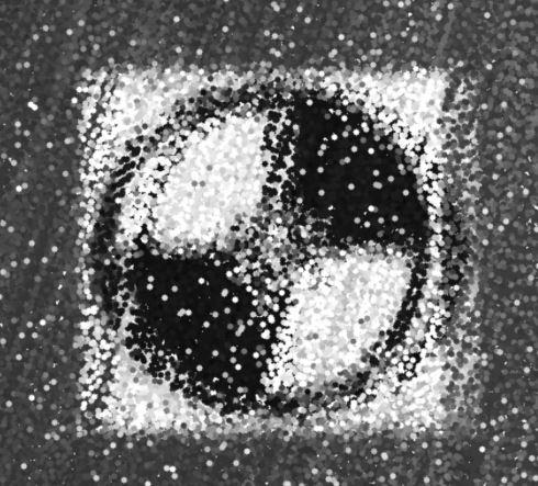
I have done something quite different and stumbled across this when dealing with Lidar point clouds. First, we lay down ground control points (painted black and white within a cross), then we fly over the area and switch the raw point cloud view to intensity. Subjectively, you can see the control points in position to your lidar point cloud.
Below is an image of a control point with lidar points coloured by intensity
Tobias K Kohoutek
Nov 14, 2018, 8:20:15 AM11/14/18
to LAStools - efficient tools for LiDAR processing
Dear Hong,
so how did you check the horizontal accuracy?
Did you check all representing points of the target against a polygon of the target?
Did you try manually to pinch the eco that represents your center point of the target and compare it against a coordinate measured by GNSS?
The problem is, and this is perfectly visible in your image, that 1 single point (center of your cross) will never be 100% represented by 1 LiDAR pulse/echo. And the module I was asking for, and the task I have to solve is, how to check horizontal accuracy of a point cloud in relation to the project scale.
Cheers,
Tobias
Tobias
Hong Tran
Apr 10, 2020, 12:27:43 AM4/10/20
to LAStools - efficient tools for LiDAR processing
I agree, no 100% positive measurement as yet. However, we did find there is a strong correlation between RMSEz and RMSExy.
I hope that helps, apologies for the delayed message by 2 years ! =O
Reply all
Reply to author
Forward
0 new messages