las1.2 to las1.4 header information

Srinu B
file signature: 'LASF'
file source ID: 0
global_encoding: 16
project ID GUID data 1-4: 00000000-0000-0000-0000-000000000000
version major.minor: 1.4
system identifier: ''
generating software: ''
file creation day/year: 112/2016
header size: 375
offset to point data: 375
number var. length records: 0
point data format: 6
point data record length: 30
number of point records: 10293254
number of points by return: 10293254 0 0 0 0
scale factor x y z: 0.0001 0.0001 0.0001
offset x y z: 6041000.0001504663 1992000.0000501564 532.28815000000009
min x y z: 6039500.0010 1991000.0001 358.0566
max x y z: 6042499.9993 1993000.0000 706.5197
start of waveform data packet record: 0
start of first extended variable length record: 308797995
number of extended_variable length records: 1
extended number of point records: 10293254
extended number of points by return: 10293254 0 0 0 0 0 0 0 0 0 0 0 0 0 0
extended variable length header record 1 of 1:
reserved 0
user ID 'LASF_Projection'
record ID 2112
length after header 1175
description 'Georeference Info'
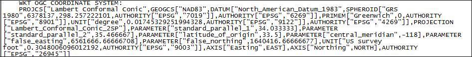
OGC COORDINATE SYSTEM WKT:
PROJCS["NAD83 / California zone 5 (ftUS)",
GEOGCS["NAD83",
DATUM["North_American_Datum_1983",
SPHEROID["GRS 1980",6378137,298.257222101,
AUTHORITY["EPSG","7019"]],
AUTHORITY["EPSG","6269"]],
PRIMEM["Greenwich",0,
AUTHORITY["EPSG","8901"]],
UNIT["degree",0.01745329251994328,
AUTHORITY["EPSG","9122"]],
AUTHORITY["EPSG","4269"]],
UNIT["US survey foot",0.3048006096012192,
AUTHORITY["EPSG","9003"]],
PROJECTION["Lambert_Conformal_Conic_2SP"],
PARAMETER["standard_parallel_1",35.46666666666667],
PARAMETER["standard_parallel_2",34.03333333333333],
PARAMETER["latitude_of_origin",33.5],
PARAMETER["central_meridian",-118],
PARAMETER["false_easting",6561666.667],
PARAMETER["false_northing",1640416.667],
AUTHORITY["EPSG","2229"],
AXIS["X",EAST],
AXIS["Y",NORTH]]
VERT_CS["North American Vertical Datum of 1988",
VERT_DATUM["North American Vertical Datum 1988",2005,
AUTHORITY["EPSG","5103"]],
UNIT["foot_survey_us",0.30480060960121924],
AXIS["Gravity-related height",UP],
AUTHORITY["EPSG","6360"]]
reporting minimum and maximum for all LAS point record entries ...
X -14999991 14999991
Y -9999998 10000000
Z -1742315 1742315
intensity 0 65535
return_number 1 1
number_of_returns 1 1
edge_of_flight_line 0 0
scan_direction_flag 0 0
classification 1 2
scan_angle_rank 0 0
user_data 0 0
point_source_ID 0 0
gps_time 0.000000 0.000000
extended_number_of_returns 1 1
extended_return_number 1 1
extended_classification 1 2
extended_scan_angle 0 0
extended_scanner_channel 0 0
WARNING: 1 points outside of header bounding box
overview over number of returns of given pulse: 10293254 0 0 0 0 0 0
histogram of classification of points:
6355094 unclassified (1)
3938160 ground (2)
real max y larger than header max y by 0.000050

Martin Isenburg
offset x y z: 6041000.0001504663 1992000.0000501564 532.28815000000009
user_data 0 0
point_source_ID 0 0
gps_time 0.000000 0.000000
extended_scanner_channel 0 0
--
Download LAStools at
http://lastools.org
http://rapidlasso.com
Be social with LAStools at
http://facebook.com/LAStools
http://twitter.com/LAStools
http://linkedin.com/groups/LAStools-4408378
Manage your settings at
http://groups.google.com/group/lastools/subscribe
Srinu B
Hi Martin,
Thanks for quick response. Basically, we unable to get the format of OGc_WKT as shown below and also vertical information not getting through lastools
Ex: Format that we are getting through las tools continuous line format
EX : Required line format as shown with vertical datum
Martin Isenburg
http://groups.google.com/d/topic/lasroom/ng3rcDSV2Gc/discussion

batt...@eaglemapping.com
VERTCRS["CGVD28 height",VDATUM["Canadian Geodetic Vertical Datum of 1928"],CS[vertical,1],AXIS["gravity-related height (H)",up],LENGTHUNIT["metre",1.0],ID["EPSG",5713]]
VERTCRS["CGVD2013 height",VDATUM["Canadian Geodetic Vertical Datum of 2013"],CS[vertical,1],AXIS["gravity-related height (H)",up],LENGTHUNIT["metre",1.0], ID["EPSG",6647]]
Martin Isenburg
--

Albert Godfrind
EX : Required line format as shown with vertical datum
Albert Godfrind | Geospatial technologies | Tel: +33 4 93 00 80 67 | Mobile: +33 6 09 97 27 23 | Skype: albert-godfrind
Oracle Server Technologies
400 Av. Roumanille, BP 309 | 06906 Sophia Antipolis cedex | France
Everything you ever wanted to know about Oracle Spatial

Thomas Knudsen
Martin Isenburg
in the latest version of LAStools (160606) you will find that las2las has some (basic) support for vertical datums in the OCG WKT output. What is the correct OGC WKT string for ellipsoid datums such as for the VerticalCSTypeGeoKey of GeoTIFF with value 5030 VertCS_WGS_84_ellipsoid ... ?
Below some (senseless) samples that show how to add various projections with vertical datums:
D:\LAStools\bin>las2las -i ..\data\fusa.laz -nad83 -utm 11N -vertical_cgvd28 -elevation_feet -set_ogc_wkt -o fusa_cgvd28_ft.laz
using datum 'NAD83' with ellipsoid 'GRS 1980'
using projection UTM 'NAD83 / UTM zone 11N'
D:\LAStools\bin>lasinfo fusa_cgvd28_ft.laz
lasinfo (160524) report for fusa_cgvd28_ft.laz
reporting all LAS header entries:
file signature: 'LASF'
file source ID: 0
project ID GUID data 1-4: 00000000-0000-0000-0000-000000000000
system identifier: 'LAStools (c) by rapidlasso GmbH'
generating software: 'las2las (version 160524)'
file creation day/year: 40/2010
header size: 227
offset to point data: 1206
number var. length records: 2
point data format: 1
point data record length: 28
number of point records: 277573
number of points by return: 263413 13879 281 0 0
scale factor x y z: 0.01 0.01 0.01
offset x y z: 0 0 0
min x y z: 277750.00 6122250.00 42.21
max x y z: 277999.99 6122499.99 64.35
variable length header record 1 of 2:
reserved 43707
user ID 'LASF_Projection'
record ID 34735
length after header 48
description 'by LAStools of rapidlasso GmbH'
GeoKeyDirectoryTag version 1.1.0 number of keys 5
key 1024 tiff_tag_location 0 count 1 value_offset 1 - GTModelTypeGeoKey: ModelTypeProjected
key 3072 tiff_tag_location 0 count 1 value_offset 26911 - ProjectedCSTypeGeoKey: NAD83 / UTM 11N
key 3076 tiff_tag_location 0 count 1 value_offset 9001 - ProjLinearUnitsGeoKey: Linear_Meter
key 4099 tiff_tag_location 0 count 1 value_offset 9002 - VerticalUnitsGeoKey: Linear_Foot
key 4096 tiff_tag_location 0 count 1 value_offset 5114 - VerticalCSTypeGeoKey: VertCS_Canadian_Geodetic_Vertical_Datum_1928
variable length header record 2 of 2:
reserved 43707
user ID 'LASF_Projection'
record ID 2112
description 'by LAStools of rapidlasso GmbH'
WKT OGC COORDINATE SYSTEM:
PROJCS["NAD83 / UTM zone 11N",GEOGCS["NAD83",DATUM["North_American_Datum_1983",SPHEROID["GRS 1980",6378137,298.257222101,AUTHORITY["EPSG","7019"]],AUTHORITY["EPSG","6269"]],PRI
MEM["Greenwich",0,AUTHORITY["EPSG","8901"]],UNIT["degree",0.01745329251994328,AUTHORITY["EPSG","9122"]],AUTHORITY["EPSG","4269"]],PROJECTION["Transverse_Mercator"],PARAMETER["latit
ude_of_origin",0],PARAMETER["central_meridian",-117],PARAMETER["scale_factor",0.9996],PARAMETER["false_easting",500000],PARAMETER["false_northing",0],UNIT["metre",1,AUTHORITY["EPSG
","9001"]],AXIS["Easting",EAST],AXIS["Northing",NORTH],AUTHORITY["EPSG","26911"]]VERT_CS["CGVD28",VERT_DATUM["Canadian Geodetic Vertical Datum of 1928",2005,AUTHORITY["EPSG","5114"
]],UNIT["foot",0.3048,AUTHORITY["EPSG","9002"]]AXIS["Gravity-related height",UP],AUTHORITY["EPSG","5713"]]
LASzip compression (version 2.4r2 c2 50000): POINT10 2 GPSTIME11 2
reporting minimum and maximum for all LAS point record entries ...
Y 612225000 612249999
Z 4221 6435
intensity 10 62293
return_number 1 3
number_of_returns 1 3
edge_of_flight_line 0 0
scan_direction_flag 0 0
scan_angle_rank 79 103
user_data 0 197
point_source_ID 1 1
gps_time 5880.963028 5886.739738
number of first returns: 263413
number of intermediate returns: 283
number of last returns: 263370
number of single returns: 249493
overview over number of returns of given pulse: 249493 27232 848 0 0 0 0
histogram of classification of points:
180868 ground (2)
37030 high vegetation (5)
42122 building (6)
D:\LAStools\bin>lasinfo fusa_cgvd2013_m.laz
lasinfo (160524) report for fusa_cgvd2013_m.laz
reporting all LAS header entries:
file signature: 'LASF'
file source ID: 0
project ID GUID data 1-4: 00000000-0000-0000-0000-000000000000
system identifier: 'LAStools (c) by rapidlasso GmbH'
generating software: 'las2las (version 160524)'
file creation day/year: 40/2010
header size: 227
offset to point data: 1206
number var. length records: 2
point data format: 1
point data record length: 28
number of point records: 277573
number of points by return: 263413 13879 281 0 0
scale factor x y z: 0.01 0.01 0.01
offset x y z: 0 0 0
min x y z: 277750.00 6122250.00 42.21
max x y z: 277999.99 6122499.99 64.35
variable length header record 1 of 2:
reserved 43707
user ID 'LASF_Projection'
record ID 34735
length after header 48
description 'by LAStools of rapidlasso GmbH'
GeoKeyDirectoryTag version 1.1.0 number of keys 5
key 1024 tiff_tag_location 0 count 1 value_offset 1 - GTModelTypeGeoKey: ModelTypeProjected
key 3072 tiff_tag_location 0 count 1 value_offset 26911 - ProjectedCSTypeGeoKey: NAD83 / UTM 11N
key 3076 tiff_tag_location 0 count 1 value_offset 9001 - ProjLinearUnitsGeoKey: Linear_Meter
key 4099 tiff_tag_location 0 count 1 value_offset 9001 - VerticalUnitsGeoKey: Linear_Meter
key 4096 tiff_tag_location 0 count 1 value_offset 1127 - VerticalCSTypeGeoKey: VertCS_Canadian_Geodetic_Vertical_Datum_2013
variable length header record 2 of 2:
reserved 43707
user ID 'LASF_Projection'
record ID 2112
description 'by LAStools of rapidlasso GmbH'
WKT OGC COORDINATE SYSTEM:
PROJCS["NAD83 / UTM zone 11N",GEOGCS["NAD83",DATUM["North_American_Datum_1983",SPHEROID["GRS 1980",6378137,298.257222101,AUTHORITY["EPSG","7019"]],AUTHORITY["EPSG","6269"]],PRI
MEM["Greenwich",0,AUTHORITY["EPSG","8901"]],UNIT["degree",0.01745329251994328,AUTHORITY["EPSG","9122"]],AUTHORITY["EPSG","4269"]],PROJECTION["Transverse_Mercator"],PARAMETER["latit
ude_of_origin",0],PARAMETER["central_meridian",-117],PARAMETER["scale_factor",0.9996],PARAMETER["false_easting",500000],PARAMETER["false_northing",0],UNIT["metre",1,AUTHORITY["EPSG
","9001"]],AXIS["Easting",EAST],AXIS["Northing",NORTH],AUTHORITY["EPSG","26911"]]VERT_CS["CGVD2013",VERT_DATUM["Canadian Geodetic Vertical Datum of 2013",2005,AUTHORITY["EPSG","112
7"]],UNIT["metre",1.0,AUTHORITY["EPSG","9001"]]AXIS["Gravity-related height",UP],AUTHORITY["EPSG","6647"]]
LASzip compression (version 2.4r2 c2 50000): POINT10 2 GPSTIME11 2
reporting minimum and maximum for all LAS point record entries ...
Y 612225000 612249999
Z 4221 6435
intensity 10 62293
return_number 1 3
number_of_returns 1 3
edge_of_flight_line 0 0
scan_direction_flag 0 0
scan_angle_rank 79 103
user_data 0 197
point_source_ID 1 1
gps_time 5880.963028 5886.739738
number of first returns: 263413
number of intermediate returns: 283
number of last returns: 263370
number of single returns: 249493
overview over number of returns of given pulse: 249493 27232 848 0 0 0 0
histogram of classification of points:
180868 ground (2)
37030 high vegetation (5)
42122 building (6)
D:\LAStools\bin>las2las -i ..\data\fusa.laz -nad83 -utm 11N -vertical_navd88 -elevation_survey_feet -set_ogc_wkt -o fusa_navd88_sft.laz
using datum 'NAD83' with ellipsoid 'GRS 1980'
using projection UTM 'NAD83 / UTM zone 11N'
D:\LAStools\bin>lasinfo fusa_navd88_sft.laz
lasinfo (160524) report for fusa_navd88_sft.laz
reporting all LAS header entries:
file signature: 'LASF'
file source ID: 0
project ID GUID data 1-4: 00000000-0000-0000-0000-000000000000
system identifier: 'LAStools (c) by rapidlasso GmbH'
generating software: 'las2las (version 160524)'
file creation day/year: 40/2010
header size: 227
offset to point data: 1223
number var. length records: 2
point data format: 1
point data record length: 28
number of point records: 277573
number of points by return: 263413 13879 281 0 0
scale factor x y z: 0.01 0.01 0.01
offset x y z: 0 0 0
min x y z: 277750.00 6122250.00 42.21
max x y z: 277999.99 6122499.99 64.35
variable length header record 1 of 2:
reserved 43707
user ID 'LASF_Projection'
record ID 34735
length after header 48
description 'by LAStools of rapidlasso GmbH'
GeoKeyDirectoryTag version 1.1.0 number of keys 5
key 1024 tiff_tag_location 0 count 1 value_offset 1 - GTModelTypeGeoKey: ModelTypeProjected
key 3072 tiff_tag_location 0 count 1 value_offset 26911 - ProjectedCSTypeGeoKey: NAD83 / UTM 11N
key 3076 tiff_tag_location 0 count 1 value_offset 9001 - ProjLinearUnitsGeoKey: Linear_Meter
key 4099 tiff_tag_location 0 count 1 value_offset 9003 - VerticalUnitsGeoKey: Linear_Foot_US_Survey
key 4096 tiff_tag_location 0 count 1 value_offset 5103 - VerticalCSTypeGeoKey: VertCS_North_American_Vertical_Datum_1988
variable length header record 2 of 2:
reserved 43707
user ID 'LASF_Projection'
record ID 2112
description 'by LAStools of rapidlasso GmbH'
WKT OGC COORDINATE SYSTEM:
PROJCS["NAD83 / UTM zone 11N",GEOGCS["NAD83",DATUM["North_American_Datum_1983",SPHEROID["GRS 1980",6378137,298.257222101,AUTHORITY["EPSG","7019"]],AUTHORITY["EPSG","6269"]],PRI
MEM["Greenwich",0,AUTHORITY["EPSG","8901"]],UNIT["degree",0.01745329251994328,AUTHORITY["EPSG","9122"]],AUTHORITY["EPSG","4269"]],PROJECTION["Transverse_Mercator"],PARAMETER["latit
ude_of_origin",0],PARAMETER["central_meridian",-117],PARAMETER["scale_factor",0.9996],PARAMETER["false_easting",500000],PARAMETER["false_northing",0],UNIT["metre",1,AUTHORITY["EPSG
","9001"]],AXIS["Easting",EAST],AXIS["Northing",NORTH],AUTHORITY["EPSG","26911"]]VERT_CS["NAVD88",VERT_DATUM["North American Vertical Datum 1988",2005,AUTHORITY["EPSG","5103"]],UNI
T["US survey foot",0.3048006096012192,AUTHORITY["EPSG","9003"]],AXIS["Gravity-related height",UP],AUTHORITY["EPSG","5703"]]
reporting minimum and maximum for all LAS point record entries ...
Y 612225000 612249999
Z 4221 6435
intensity 10 62293
return_number 1 3
number_of_returns 1 3
edge_of_flight_line 0 0
scan_direction_flag 0 0
scan_angle_rank 79 103
user_data 0 197
point_source_ID 1 1
gps_time 5880.963028 5886.739738
number of first returns: 263413
number of intermediate returns: 283
number of last returns: 263370
number of single returns: 249493
overview over number of returns of given pulse: 249493 27232 848 0 0 0 0
histogram of classification of points:
180868 ground (2)
37030 high vegetation (5)
42122 building (6)
D:\LAStools\bin>las2las -i ..\data\fusa.laz -epsg 2198 -vertical_dvr90 -elevation_feet -set_ogc_wkt -o fusa_dvr90.laz
D:\LAStools\bin>lasinfo fusa_dvr90.laz
lasinfo (160524) report for fusa_dvr90.laz
reporting all LAS header entries:
file signature: 'LASF'
file source ID: 0
project ID GUID data 1-4: 00000000-0000-0000-0000-000000000000
system identifier: 'LAStools (c) by rapidlasso GmbH'
generating software: 'las2las (version 160524)'
file creation day/year: 40/2010
header size: 227
offset to point data: 1208
number var. length records: 2
point data format: 1
point data record length: 28
number of point records: 277573
number of points by return: 263413 13879 281 0 0
scale factor x y z: 0.01 0.01 0.01
offset x y z: 0 0 0
min x y z: 277750.00 6122250.00 42.21
max x y z: 277999.99 6122499.99 64.35
variable length header record 1 of 2:
reserved 43707
user ID 'LASF_Projection'
record ID 34735
length after header 48
description 'by LAStools of rapidlasso GmbH'
GeoKeyDirectoryTag version 1.1.0 number of keys 5
key 1024 tiff_tag_location 0 count 1 value_offset 1 - GTModelTypeGeoKey: ModelTypeProjected
key 3072 tiff_tag_location 0 count 1 value_offset 2198 - ProjectedCSTypeGeoKey: ETRS89 / Kp2000 Bornholm
key 3076 tiff_tag_location 0 count 1 value_offset 9001 - ProjLinearUnitsGeoKey: Linear_Meter
key 4099 tiff_tag_location 0 count 1 value_offset 9002 - VerticalUnitsGeoKey: Linear_Foot
key 4096 tiff_tag_location 0 count 1 value_offset 5206 - VerticalCSTypeGeoKey: VertCS_Dansk_Vertikal_Reference_1990
variable length header record 2 of 2:
reserved 43707
user ID 'LASF_Projection'
record ID 2112
description 'by LAStools of rapidlasso GmbH'
WKT OGC COORDINATE SYSTEM:
PROJCS["ETRS89 / Kp2000 Bornholm",GEOGCS["ETRS89",DATUM["European_Terrestrial_Reference_System_1989",SPHEROID["GRS 1980",6378137,298.257222101,AUTHORITY["EPSG","7019"]],AUTHORI
TY["EPSG","6258"]],PRIMEM["Greenwich",0,AUTHORITY["EPSG","8901"]],UNIT["degree",0.01745329251994328,AUTHORITY["EPSG","9122"]],AUTHORITY["EPSG","4258"]],PROJECTION["Transverse_Merca
tor"],PARAMETER["latitude_of_origin",0],PARAMETER["central_meridian",15],PARAMETER["scale_factor",1],PARAMETER["false_easting",900000],PARAMETER["false_northing",0],UNIT["metre",1,
AUTHORITY["EPSG","9001"]],AXIS["Easting",EAST],AXIS["Northing",NORTH],AUTHORITY["EPSG","2198"]]VERT_CS["DVR90",VERT_DATUM["Dansk Vertikal Reference 1990",2005,AUTHORITY["EPSG","520
6"]],UNIT["foot",0.3048,AUTHORITY["EPSG","9002"]]AXIS["Gravity-related height",UP],AUTHORITY["EPSG","5799"]]
LASzip compression (version 2.4r2 c2 50000): POINT10 2 GPSTIME11 2reporting minimum and maximum for all LAS point record entries ...
X 27775000 27799999
Y 612225000 612249999
Z 4221 6435
intensity 10 62293
return_number 1 3
number_of_returns 1 3
edge_of_flight_line 0 0
scan_direction_flag 0 0
scan_angle_rank 79 103
user_data 0 197
point_source_ID 1 1
gps_time 5880.963028 5886.739738
number of first returns: 263413
number of intermediate returns: 283
number of last returns: 263370
number of single returns: 249493
overview over number of returns of given pulse: 249493 27232 848 0 0 0 0
histogram of classification of points:
180868 ground (2)
37030 high vegetation (5)
42122 building (6)
D:\LAStools\bin>las2las -i ..\data\fusa.laz -epsg 2197 -vertical_dvr90 -elevation_feet -set_ogc_wkt -o fusa_dvr90.laz
D:\LAStools\bin>lasinfo fusa_dvr90.laz
lasinfo (160524) report for fusa_dvr90.laz
reporting all LAS header entries:
file signature: 'LASF'
file source ID: 0
project ID GUID data 1-4: 00000000-0000-0000-0000-000000000000
system identifier: 'LAStools (c) by rapidlasso GmbH'
generating software: 'las2las (version 160524)'
file creation day/year: 40/2010
header size: 227
offset to point data: 1213
number var. length records: 2
point data format: 1
point data record length: 28
number of point records: 277573
number of points by return: 263413 13879 281 0 0
scale factor x y z: 0.01 0.01 0.01
offset x y z: 0 0 0
min x y z: 277750.00 6122250.00 42.21
max x y z: 277999.99 6122499.99 64.35
variable length header record 1 of 2:
reserved 43707
user ID 'LASF_Projection'
record ID 34735
length after header 48
description 'by LAStools of rapidlasso GmbH'
GeoKeyDirectoryTag version 1.1.0 number of keys 5
key 1024 tiff_tag_location 0 count 1 value_offset 1 - GTModelTypeGeoKey: ModelTypeProjected
key 3072 tiff_tag_location 0 count 1 value_offset 2197 - ProjectedCSTypeGeoKey: ETRS89 / Kp2000 Zealand
key 3076 tiff_tag_location 0 count 1 value_offset 9001 - ProjLinearUnitsGeoKey: Linear_Meter
key 4099 tiff_tag_location 0 count 1 value_offset 9002 - VerticalUnitsGeoKey: Linear_Foot
key 4096 tiff_tag_location 0 count 1 value_offset 5206 - VerticalCSTypeGeoKey: VertCS_Dansk_Vertikal_Reference_1990
variable length header record 2 of 2:
reserved 43707
user ID 'LASF_Projection'
record ID 2112
description 'by LAStools of rapidlasso GmbH'
WKT OGC COORDINATE SYSTEM:
PROJCS["ETRS89 / Kp2000 Zealand",GEOGCS["ETRS89",DATUM["European_Terrestrial_Reference_System_1989",SPHEROID["GRS 1980",6378137,298.257222101,AUTHORITY["EPSG","7019"]],AUTHORIT
Y["EPSG","6258"]],PRIMEM["Greenwich",0,AUTHORITY["EPSG","8901"]],UNIT["degree",0.01745329251994328,AUTHORITY["EPSG","9122"]],AUTHORITY["EPSG","4258"]],PROJECTION["Transverse_Mercat
or"],PARAMETER["latitude_of_origin",0],PARAMETER["central_meridian",12],PARAMETER["scale_factor",0.99995],PARAMETER["false_easting",500000],PARAMETER["false_northing",0],UNIT["metr
e",1,AUTHORITY["EPSG","9001"]],AXIS["Easting",EAST],AXIS["Northing",NORTH],AUTHORITY["EPSG","2197"]]VERT_CS["DVR90",VERT_DATUM["Dansk Vertikal Reference 1990",2005,AUTHORITY["EPSG"
,"5206"]],UNIT["foot",0.3048,AUTHORITY["EPSG","9002"]]AXIS["Gravity-related height",UP],AUTHORITY["EPSG","5799"]]
LASzip compression (version 2.4r2 c2 50000): POINT10 2 GPSTIME11 2reporting minimum and maximum for all LAS point record entries ...
X 27775000 27799999
Y 612225000 612249999
Z 4221 6435
intensity 10 62293
return_number 1 3
number_of_returns 1 3
edge_of_flight_line 0 0
scan_direction_flag 0 0
scan_angle_rank 79 103
user_data 0 197
point_source_ID 1 1
gps_time 5880.963028 5886.739738
number of first returns: 263413
number of intermediate returns: 283
number of last returns: 263370
number of single returns: 249493
overview over number of returns of given pulse: 249493 27232 848 0 0 0 0
histogram of classification of points:
180868 ground (2)
37030 high vegetation (5)
42122 building (6)
D:\LAStools\bin>las2las -i ..\data\fusa.laz -epsg 25832 -vertical_dvr90 -elevation_feet -set_ogc_wkt -o fusa_dvr90.laz
D:\LAStools\bin>lasinfo fusa_dvr90.laz
lasinfo (160524) report for fusa_dvr90.laz
reporting all LAS header entries:
file signature: 'LASF'
file source ID: 0
project ID GUID data 1-4: 00000000-0000-0000-0000-000000000000
system identifier: 'LAStools (c) by rapidlasso GmbH'
generating software: 'las2las (version 160524)'
file creation day/year: 40/2010
header size: 227
offset to point data: 1205
number var. length records: 2
point data format: 1
point data record length: 28
number of point records: 277573
number of points by return: 263413 13879 281 0 0
scale factor x y z: 0.01 0.01 0.01
offset x y z: 0 0 0
min x y z: 277750.00 6122250.00 42.21
max x y z: 277999.99 6122499.99 64.35
variable length header record 1 of 2:
reserved 43707
user ID 'LASF_Projection'
record ID 34735
length after header 48
description 'by LAStools of rapidlasso GmbH'
GeoKeyDirectoryTag version 1.1.0 number of keys 5
key 1024 tiff_tag_location 0 count 1 value_offset 1 - GTModelTypeGeoKey: ModelTypeProjected
key 3072 tiff_tag_location 0 count 1 value_offset 25832 - ProjectedCSTypeGeoKey: ETRS89 / UTM 32N
key 3076 tiff_tag_location 0 count 1 value_offset 9001 - ProjLinearUnitsGeoKey: Linear_Meter
key 4099 tiff_tag_location 0 count 1 value_offset 9002 - VerticalUnitsGeoKey: Linear_Foot
key 4096 tiff_tag_location 0 count 1 value_offset 5206 - VerticalCSTypeGeoKey: VertCS_Dansk_Vertikal_Reference_1990
variable length header record 2 of 2:
reserved 43707
user ID 'LASF_Projection'
record ID 2112
description 'by LAStools of rapidlasso GmbH'
WKT OGC COORDINATE SYSTEM:
PROJCS["ETRS89 / UTM 32N",GEOGCS["ETRS89",DATUM["European_Terrestrial_Reference_System_1989",SPHEROID["GRS 1980",6378137,298.257222101,AUTHORITY["EPSG","7019"]],AUTHORITY["EPSG
","6258"]],PRIMEM["Greenwich",0,AUTHORITY["EPSG","8901"]],UNIT["degree",0.01745329251994328,AUTHORITY["EPSG","9122"]],AUTHORITY["EPSG","4258"]],PROJECTION["Transverse_Mercator"],PA
RAMETER["latitude_of_origin",0],PARAMETER["central_meridian",9],PARAMETER["scale_factor",0.9996],PARAMETER["false_easting",500000],PARAMETER["false_northing",0],UNIT["metre",1,AUTH
ORITY["EPSG","9001"]],AXIS["Easting",EAST],AXIS["Northing",NORTH],AUTHORITY["EPSG","25832"]]VERT_CS["DVR90",VERT_DATUM["Dansk Vertikal Reference 1990",2005,AUTHORITY["EPSG","5206"]
],UNIT["foot",0.3048,AUTHORITY["EPSG","9002"]]AXIS["Gravity-related height",UP],AUTHORITY["EPSG","5799"]]
LASzip compression (version 2.4r2 c2 50000): POINT10 2 GPSTIME11 2reporting minimum and maximum for all LAS point record entries ...
X 27775000 27799999
Y 612225000 612249999
Z 4221 6435
intensity 10 62293
return_number 1 3
number_of_returns 1 3
edge_of_flight_line 0 0
scan_direction_flag 0 0
scan_angle_rank 79 103
user_data 0 197
point_source_ID 1 1
gps_time 5880.963028 5886.739738
number of first returns: 263413
number of intermediate returns: 283
number of last returns: 263370
number of single returns: 249493
overview over number of returns of given pulse: 249493 27232 848 0 0 0 0
histogram of classification of points:
180868 ground (2)
37030 high vegetation (5)
42122 building (6)
D:\LAStools\bin>las2las -i ..\data\fusa.laz -epsg 25833 -vertical_dvr90 -elevation_feet -set_ogc_wkt -o fusa_dvr90.laz
D:\LAStools\bin>lasinfo fusa_dvr90.laz
lasinfo (160524) report for fusa_dvr90.laz
reporting all LAS header entries:
file signature: 'LASF'
file source ID: 0
project ID GUID data 1-4: 00000000-0000-0000-0000-000000000000
system identifier: 'LAStools (c) by rapidlasso GmbH'
generating software: 'las2las (version 160524)'
file creation day/year: 40/2010
header size: 227
offset to point data: 1206
number var. length records: 2
point data format: 1
point data record length: 28
number of point records: 277573
number of points by return: 263413 13879 281 0 0
scale factor x y z: 0.01 0.01 0.01
offset x y z: 0 0 0
min x y z: 277750.00 6122250.00 42.21
max x y z: 277999.99 6122499.99 64.35
variable length header record 1 of 2:
reserved 43707
user ID 'LASF_Projection'
record ID 34735
length after header 48
description 'by LAStools of rapidlasso GmbH'
GeoKeyDirectoryTag version 1.1.0 number of keys 5
key 1024 tiff_tag_location 0 count 1 value_offset 1 - GTModelTypeGeoKey: ModelTypeProjected
key 3072 tiff_tag_location 0 count 1 value_offset 25833 - ProjectedCSTypeGeoKey: ETRS89 / UTM 33N
key 3076 tiff_tag_location 0 count 1 value_offset 9001 - ProjLinearUnitsGeoKey: Linear_Meter
key 4099 tiff_tag_location 0 count 1 value_offset 9002 - VerticalUnitsGeoKey: Linear_Foot
key 4096 tiff_tag_location 0 count 1 value_offset 5206 - VerticalCSTypeGeoKey: VertCS_Dansk_Vertikal_Reference_1990
variable length header record 2 of 2:
reserved 43707
user ID 'LASF_Projection'
record ID 2112
description 'by LAStools of rapidlasso GmbH'
WKT OGC COORDINATE SYSTEM:
PROJCS["ETRS89 / UTM 33N",GEOGCS["ETRS89",DATUM["European_Terrestrial_Reference_System_1989",SPHEROID["GRS 1980",6378137,298.257222101,AUTHORITY["EPSG","7019"]],AUTHORITY["EPSG
","6258"]],PRIMEM["Greenwich",0,AUTHORITY["EPSG","8901"]],UNIT["degree",0.01745329251994328,AUTHORITY["EPSG","9122"]],AUTHORITY["EPSG","4258"]],PROJECTION["Transverse_Mercator"],PA
RAMETER["latitude_of_origin",0],PARAMETER["central_meridian",15],PARAMETER["scale_factor",0.9996],PARAMETER["false_easting",500000],PARAMETER["false_northing",0],UNIT["metre",1,AUT
HORITY["EPSG","9001"]],AXIS["Easting",EAST],AXIS["Northing",NORTH],AUTHORITY["EPSG","25833"]]VERT_CS["DVR90",VERT_DATUM["Dansk Vertikal Reference 1990",2005,AUTHORITY["EPSG","5206"
]],UNIT["foot",0.3048,AUTHORITY["EPSG","9002"]]AXIS["Gravity-related height",UP],AUTHORITY["EPSG","5799"]]
LASzip compression (version 2.4r2 c2 50000): POINT10 2 GPSTIME11 2reporting minimum and maximum for all LAS point record entries ...
X 27775000 27799999
Y 612225000 612249999
Z 4221 6435
intensity 10 62293
return_number 1 3
number_of_returns 1 3
edge_of_flight_line 0 0
scan_direction_flag 0 0
scan_angle_rank 79 103
user_data 0 197
point_source_ID 1 1
gps_time 5880.963028 5886.739738
number of first returns: 263413
number of intermediate returns: 283
number of last returns: 263370
number of single returns: 249493
overview over number of returns of given pulse: 249493 27232 848 0 0 0 0
histogram of classification of points:
180868 ground (2)
37030 high vegetation (5)
42122 building (6)
On Fri, May 27, 2016 at 3:47 PM, Martin Isenburg <martin....@gmail.com> wrote:
>
> Hello Srinu,
>
> that is not too surprising as we have not yet implemented OGC WKT support for the vertical datum. It is on our TODO list already. Which are the common vertical datums that people are using? We'll be adding support for a few of the most common ones in the coming weeks ...
>
> Regards,
>
> Martin
>
> PS: But pay attention to the other issues with your LAS 1.4 file. As is it will not pass the check with the latest version of the LASvalidator. Also see this discussion on that topic:
>
> http://groups.google.com/d/topic/lasroom/ng3rcDSV2Gc/discussion
>
> On Friday, May 27, 2016 at 3:39:55 PM UTC+2, Srinu B wrote:
>>
>> Hi Martin,
>>
>>
>>
>> Thanks for quick response. Basically, we unable to get the format of OGc_WKT as shown below and also vertical information not getting through lastools
>>
>>
>>
>> Ex: Format that we are getting through las tools continuous line format
>>
>>
>>
>>
>>
>>
>>
>>
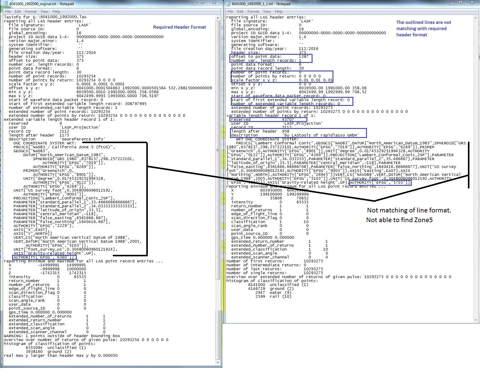
Srinu B
Hi ,
Yes. Now the lastools is able to write vertical datum in header information. However, there are few anomalies between client required format and lastools generated format. Please find enclosed Header_comparision. jpg for your quick reference. Would you suggest.
Thanks and Regards,
BSR
On Friday, May 27, 2016 at 6:26:18 PM UTC+5:30, Srinu B wrote:
Martin Isenburg
[...]
--

Evon Silvia
 |
Evon Silvia PLS
Solutions Developer 517 SW 2nd Street, Suite 400, Corvallis, OR 97333 P: (541) 452-8502 |
Martin Isenburg
Hello Evon,
Thanks for the clarificstion. The latest release of LAStools (160703) also addresses the issue of the differing EPSG codes for NAVD88. EPSG code 5703 is now used when the vertical units are meters white code 6360 is used when not (e.g. because '-elevation_survey_feet' is specified in the command line or because the GEOFF tags say so) ...
Are there also different EPSG codes for the older vertical datum NGVD29 ... ?
We'll see about improving EVLR support. First we really need to finish LASzip for LAS 1.4 as NOAA and USGS seem to start receiving data using the new point types ...
Regards,
Martin
Evon Silvia

Mathieu Tachon
In Norway, the vertical datums commonly used are NN54 (EPSG:5776) and NN2000 (EPSG:5941). Would it be possible to add support for them in lastools?
The OGC WKT are as follows:
NN54: VERT_CS["NN54 height",VERT_DATUM["Norway Normal Null 1954",2005,AUTHORITY["EPSG","5174"]],UNIT["metre",1,AUTHORITY["EPSG","9001"]],AXIS["Up",UP],AUTHORITY["EPSG","5776"]]
NN2000: VERT_CS["NN2000 height",VERT_DATUM["Norway Normal Null 2000",2005,AUTHORITY["EPSG","1096"]],UNIT["metre",1,AUTHORITY["EPSG","9001"]],AXIS["Up",UP],AUTHORITY["EPSG","5941"]]
Thank you.
Regards,
Mathieu
Martin Isenburg
the vertical datums NN54 (EPSG:5776) and NN2000 (EPSG:5941) were added to LAStools in the latest version of today (160710). Some (fake) examples of how to use the new ' -vertical_nn54' and ' -vertical_nn2000' with las2las and '-set_ogc_wkt' are below.
D:\LAStools\bin>las2las -i ..\data\fusa.laz -utm 22n -vertical_nn54 -set_ogc_wkt -o dummy.laz
using projection UTM 'WGS 84 / UTM zone 22N'
D:\LAStools\bin>lasinfo -i dummy.laz
lasinfo (160710) report for dummy.laz
reporting all LAS header entries:
file signature: 'LASF'
file source ID: 0
project ID GUID data 1-4: 00000000-0000-0000-0000-000000000000
system identifier: 'LAStools (c) by rapidlasso GmbH'
file creation day/year: 40/2010
header size: 227
number var. length records: 2
point data format: 1
point data record length: 28
number of point records: 277573
number of points by return: 263413 13879 281 0 0
scale factor x y z: 0.01 0.01 0.01
offset x y z: 0 0 0
min x y z: 277750.00 6122250.00 42.21
max x y z: 277999.99 6122499.99 64.35
reserved 0
user ID 'LASF_Projection'
length after header 48
description 'by LAStools of rapidlasso GmbH'
GeoKeyDirectoryTag version 1.1.0 number of keys 5
key 1024 tiff_tag_location 0 count 1 value_offset 1 - GTModelTypeGeoKey: ModelTypeProjected
key 3076 tiff_tag_location 0 count 1 value_offset 9001 - ProjLinearUnitsGeoKey: Linear_Meter
key 4099 tiff_tag_location 0 count 1 value_offset 9001 - VerticalUnitsGeoKey: Linear_Meter
variable length header record 2 of 2:
user ID 'LASF_Projection'
record ID 2112
description 'by LAStools of rapidlasso GmbH'
WKT OGC COORDINATE SYSTEM:
LASzip compression (version 2.4r2 c2 50000): POINT10 2 GPSTIME11 2
Y 612225000 612249999
Z 4221 6435
intensity 10 62293
return_number 1 3
number_of_returns 1 3
scan_direction_flag 0 0
scan_angle_rank 79 103
user_data 0 197
point_source_ID 1 1
gps_time 5880.963028 5886.739738
number of first returns: 263413
number of intermediate returns: 283
number of last returns: 263370
number of single returns: 249493
histogram of classification of points:
180868 ground (2)
37030 high vegetation (5)
42122 building (6)