panorama aerial photography
17 views
Skip to first unread message

Hagit Keysar
Apr 6, 2014, 3:23:50 PM4/6/14
to publicla...@googlegroups.com, grassroo...@googlegroups.com
Hey there
I am sure this was discussed before, but couldn't find anything
Can anyone suggest ways for doing panorama aerial photography?
I'd like to try the bottle rig and tilt the camera to the right angle
if anyone had done that before i'll be happy to hear how.
Also how does it work with the stitching? is there a way to create an angle in mapknitter's background layers?
thanks!
hagit
----
----
חגית קיסר | 054-6395936
حغيت كيسار | hagit keysar
حغيت كيسار | hagit keysar

Chris Fastie
Apr 8, 2014, 8:52:54 AM4/8/14
to grassroo...@googlegroups.com, publicla...@googlegroups.com
Hi Hagit,
Stitching oblique aerial photos into panoramas is commonly done. Usually the photos are taken by a motorized rig that pans and tilts in increments so the entire scene of interest is systematically covered. The trick is to get all the required photos taken fast while the kite or balloon is in the same place. If the camera location changes much during the shooting, the photos will not stitch together well. So there is a lot of luck involved.
I don't think Mapknitter makes any accommodations for oblique photos. The easiest way to stitch overlapping aerial obliques is to drag them all into Microsoft ICE (free, Windows only). It does an amazing job of stitching and blending the edges. If ICE successfully makes a panorama, it can be uploaded to Photosynth.net and displayed in a great spherical viewer. It can also be exported from ICE as a flat file for printing, etc. Here is a panorama at Photosynth from 22 oblique aerials that ICE stitched into a complete half sphere: http://photosynth.net/view.aspx?cid=1f65dcb9-6c0d-4d84-99e6-ab7569eef21b. This is also printed six feet long and hangs on my wall. Here is the flat version at gigapan: http://www.gigapan.com/gigapans/116414
Chris
Hagit Keysar
Apr 8, 2014, 9:19:33 AM4/8/14
to grassroo...@googlegroups.com, publicla...@googlegroups.com, hilla g
Hi Chris and all, thanks all for your helpful replys
Chris, that's a beautiful example! I was thinking about walking with the kite once it is stabilized, but you are probably right, it will create a lot of differences between each photo and will be difficult to stitch.
I am cc'ing Hilla here who wants to do the panorama as part of her student architecture project in Jerusalem, it sounds like building the motorized rig is an advanced level in comparison to the plastic bottle rig :-)
not sure it will be possible in this framework, but in case it would is there a model you can recommend?
hagit
----
----
חגית קיסר | 054-6395936
حغيت كيسار | hagit keysar
حغيت كيسار | hagit keysar
--
-- Post to this group at grassroo...@googlegroups.com. To unsubscribe, email grassrootsmapp...@googlegroups.com. Options at https://groups.google.com/d/forum/grassrootsmapping?hl=en
---
You received this message because you are subscribed to the Google Groups "grassrootsmapping" group.
To unsubscribe from this group and stop receiving emails from it, send an email to grassrootsmapp...@googlegroups.com.

Patrick Coyle
Apr 8, 2014, 1:16:11 PM4/8/14
to grassroo...@googlegroups.com, publicla...@googlegroups.com, hilla g
I thought of Chris and some of his nice examples. In addition to ICE for autostitching, some of the free Surface From Motion tools like the web-based 123DCatch from Autodesk (http://www.123dapp.com/catch), make a 3D model that you can make a map view from. Others are more savvy than me on this, but one issue is that the traditional panorama tools like the camera to be stationary, which is usually not the case for kite or balloon rigs aloft. For the actual panorama motion, consider ideas in rigs like these with motorized autosteppers for the rig with camera:
http://www.brooxes.com/newsite/BBKK/KITS.html
There are also several examples of the kind of panoramas this KAP community has made at: http://www.brooxes.com/newsite/panoramas/PANOS.html
http://www.brooxes.com/newsite/BBKK/KITS.html
There are also several examples of the kind of panoramas this KAP community has made at: http://www.brooxes.com/newsite/panoramas/PANOS.html
Chris Fastie
Apr 8, 2014, 1:28:17 PM4/8/14
to grassroo...@googlegroups.com, hilla g
Hagit,
You are correct that it is a big step from the soda bottle rig to a motorized pan/tilt rig. You can buy a rig for 200-300 euros, but it is a lot harder than buying a camera. It is still a DIY activity, so some research is required, and it depends on what kind of camera you will use (e.g., can it run CHDK?), how big the camera is, and whether you want to control it from the ground via radio or have it automatically point and take photos. There are lots of options at Kapshop including the Modular 1. You can use that with either radio control or a CAMRemote (both cost another 100 euros).
There are also simpler ways to get the camera to point in different directions and shoot. If a Canon Powershot is shooting every few seconds via CHDK, you can use:
The energy harvester: (at youtube, and at shapeways). I might try to print one of these and try it out.
The silly putty rig: Youtube
A wind-up kitchen timer which rotates the whole rig: http://www.getawaymoments.com/2011/07/how-to-make-cheap-and-easy-ikea-time.html
You can add complexity as desired,
Chris

Eymund Diegel
Apr 8, 2014, 3:09:05 PM4/8/14
to grassroo...@googlegroups.com, publicla...@googlegroups.com
Hi Chris,

That Middlebury Photosynth panorama is really impressive.
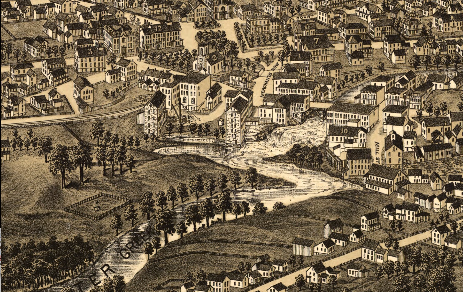
There is a an older 1886 Museum of American Memory version here so you can see how the landscape has changed.
Shows the old since demolished millworks and since buried pond.
The Museum of American Memory has a surprising number of birds eye views of small towns that can be invaluable for setting up "before and after" study projects.
Hagit Keysar
Apr 8, 2014, 4:23:52 PM4/8/14
to grassroo...@googlegroups.com, publicla...@googlegroups.com, hilla g
Eymund, this is incredible!
I love this IKEA time-lapse panning unit...
thank you all for the great suggestions!
----
----
חגית קיסר | 054-6395936
حغيت كيسار | hagit keysar
حغيت كيسار | hagit keysar
Chris Fastie
Apr 9, 2014, 8:16:44 AM4/9/14
to grassroo...@googlegroups.com, publicla...@googlegroups.com, hilla g
Eymund, that's fantastic. I had not seen the Burleigh bird's eye map. I am now on a mission to retake my kite panorama from that vantage point. That is added to my mission to retake my Bristol Vermont panorama from a different perspective to match George Norris's 1889 bird's eye map. George Norris sketched the background mountains from the same place I flew the kite, but the village is depicted from a different angle. You can see the strange match-up of the two images here at a friend's clever side by side viewer. Click "change view" in the upper right when you get there, and drag the right hand image around to scroll.
Must find other bird's eye maps!
Reply all
Reply to author
Forward
0 new messages