Your thoughts and suggestions on Map Maker update - Jan 18, 2013
567 views
Skip to first unread message

Sneha
Jan 18, 2013, 12:11:05 AM1/18/13
to google-...@googlegroups.com
Dear mappers,
Please post your thoughts and suggestions on the recent release on this thread.
Thanks,
Sneha
Sneha
Jan 18, 2013, 12:16:48 AM1/18/13
to google-...@googlegroups.com
Here is the release announcement.
Saikrishna Arcot
Jan 18, 2013, 12:19:00 AM1/18/13
to google-...@googlegroups.com
When creating a ETA/PL road, and setting the appropriate attributes, the attributes aren't taken into account. Instead, the road is created with default attributes (Local road, Two way, no Segment Usage, etc.).
Also, on newly-created unnamed roads, the automatic "Unnamed" name isn't created, and therefore there's no "Edit entire" option.
delta fox
Jan 18, 2013, 4:27:33 AM1/18/13
to google-...@googlegroups.com
Traffic signs: as it does not appear on the maps, is there any interest adding such signs ? Does it add time to driving directions ? BTW, the help has been updated for ferries, not for traffic signs. And the symbol for "no restrictions" is the traffic sign for "no traffic allowed", which is misleading !
 is the traffic sign for "no traffic allowed", which is misleading !
Domanost
Jan 18, 2013, 4:29:47 AM1/18/13
to google-...@googlegroups.com
I have been having the same problem after doing some parking lots had to go back and change again.
Bill Meier
Jan 18, 2013, 7:00:41 AM1/18/13
to google-...@googlegroups.com
This has worked fine for me. just set the terminal and ETA attribute when creating the road before you save it
gzub
Jan 18, 2013, 9:11:30 AM1/18/13
to google-...@googlegroups.com
There are two categories where you removed website where I think one could be useful....
Playgrounds - Often for town run playgrounds there could be a website with information on the appropriate age, whether the playground is handicap accessible and other information...
"Golf Course - Golf Shop" - This category is a duplicate of the "Golf Shop" category and should be deprecated, or the website field should be listed... There can be web pages for the shop which is part of the golf course, it could even be run by a separate business.
Geoff
Geoff
Cory Hughart
Jan 18, 2013, 9:21:29 AM1/18/13
to google-...@googlegroups.com
Not that this pertains directly to the update (Road + Railway intersection addition brought this to mind), but the method for creating an intersection (by creating a dummy road) is very clumsy and prone to denials that can injure a mapper's rating. Even if you explain properly, you're still taking a risk. This doesn't facilitate better crowdsourced data. A tool for bisecting lines would be very helpful.
Saikrishna Arcot
Jan 19, 2013, 7:31:38 AM1/19/13
to google-...@googlegroups.com
Looks like this has been resolved.
Andrew
Jan 19, 2013, 7:41:59 AM1/19/13
to google-...@googlegroups.com
I add traffic signs and they do have an effect on navigation directions and time. The more detail you fill in the more accurate the results are. You do have to be careful, if you add stops signs, yield signs etc. on higher priority roads but not on the lower priority ones then navigation will think the route with less signs is faster and if it thinks there is enough time saved it will redirect that way. It is best therefore to work your way up through the street priority so you don't accidently send the traffic off the main roads to the side streets. Signs on dead end terminal roads obviously don't do much.
I have added a couple of the new traffic light signs to maps and will be watching to see how they affect navigation.
ahmed mousa
Jan 19, 2013, 10:35:47 AM1/19/13
to google-...@googlegroups.com
Simple proposal
Add this feature at intersections
 1- Road Wrap

 2-The road is divided into two parts

Regards
Ahmed Mousa
susan johns
Jan 20, 2013, 9:43:49 AM1/20/13
to google-...@googlegroups.com
Thank u for u knowlage
Otter
Jan 20, 2013, 10:13:54 AM1/20/13
to google-...@googlegroups.com
I agree that playgrounds should still retain the website field. As was said before, cities often have information on their websites about playgrounds that might be relevant.
On Thursday, January 17, 2013 11:11:05 PM UTC-6, Sneha wrote:
On Thursday, January 17, 2013 11:11:05 PM UTC-6, Sneha wrote:
Joscelin Trouwborst
Feb 11, 2013, 1:08:31 PM2/11/13
to google-...@googlegroups.com
I feel that the interface change that now puts the choice about the nature of the feature (place, building, ...) at an earlier stage is an improvement. However, I feel the Help text could do with further improvement still. Also, more on the spot Help that would map makers to make informed and good decisions on this. Especially because changing mistakes here has become more cumbersome, I feel.
anurg72
Feb 11, 2013, 1:50:02 PM2/11/13
to google-...@googlegroups.com
hey, earlier changes made to Google maps will be counted?
Avinash Jadhav
Feb 12, 2013, 1:59:18 AM2/12/13
to google-...@googlegroups.com
After adding the place... how much time it takes to process?
ghostriderhahahaha
Feb 14, 2013, 3:07:05 AM2/14/13
to google-...@googlegroups.com
Thanks for the update and approving my edits, Do u also belongs to gurgaon city?
Regards
On Friday, 18 January 2013 10:41:05 UTC+5:30, Sneha wrote:
Joshy George
Feb 17, 2013, 6:50:26 PM2/17/13
to google-...@googlegroups.com
I have made some edit Thottumukkam area pls chk http://goo.gl/MkPDr
Andrew Sawyer
Feb 17, 2013, 8:56:42 PM2/17/13
to General Map Maker on behalf of Joshy George
This thread is for discussing the January 18th update. Please post Review Requests in the proper sub-forum with the location in the Subject line.
From: Joshy George via General Map Maker <google-mapmaker+noreply-APn2wQdm...@googlegroups.com>
Sender: General Map Maker on behalf of Joshy George <google-...@googlegroups.com>
Date: Sun, 17 Feb 2013 15:50:26 -0800 (PST)
ReplyTo: General Map Maker on behalf of Joshy George <google-...@googlegroups.com>
Subject: Re: Your thoughts and suggestions on Map Maker update - Jan 18,
2013
--
--
You received this message because you are subscribed to the “General Map Maker” Google Group.
- To post a public response in this same thread, please reply to this e-mail.
- To find a list of Frequently Asked Questions, visit- http://goo.gl/yuVdY
- To post a new topic, visit- http://goo.gl/DeX9Z & select 'Post a question'
- To unsubscribe from this list, manage your subscriptions here: http://goo.gl/oGfnJ
Thanks for using Google Map Maker! =)
---
You received this message because you are subscribed to the Google Groups "General Map Maker" group.
To unsubscribe from this group and stop receiving emails from it, send an email to google-mapmak...@googlegroups.com.
For more options, visit https://groups.google.com/groups/opt_out.
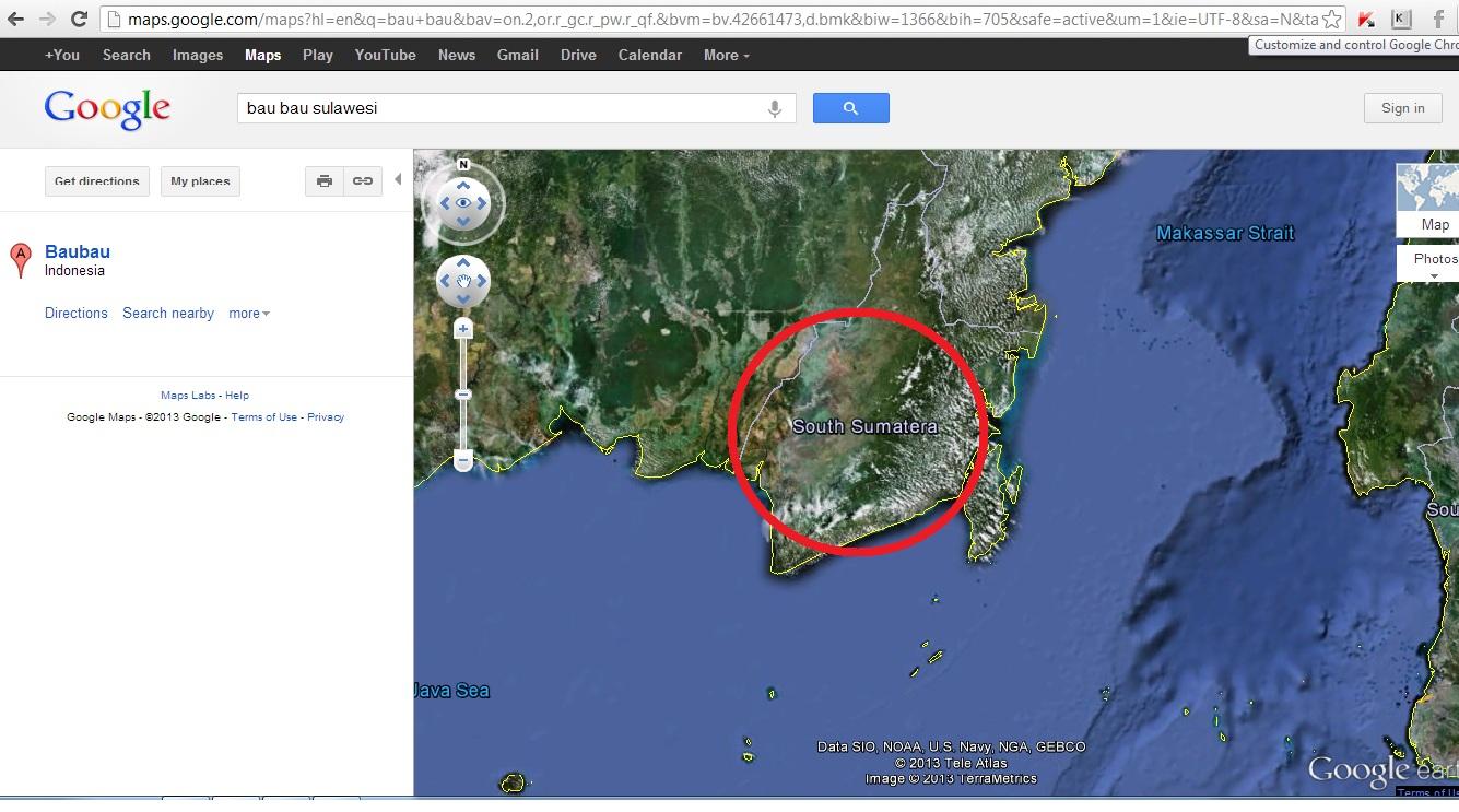
Rachmadi Permana
Feb 21, 2013, 2:58:05 AM2/21/13
to google-...@googlegroups.com
Surabaya, 21 February 2013
Dear Concerns,
Does anybody knows who posted this wrong name ? Do I deserve a prize finding it ? :)
It should read: "South Borneo" or "South Kalimantan" instead of "South Sumatera"
Regards/
Rachmadi
=======
Rajendra Lashkari
Feb 21, 2013, 3:49:27 AM2/21/13
to google-...@googlegroups.com
बृहस्पतिवार, 17 जनवरी 2013 9:11:05 pm UTC-8 को, Sneha ने लिखा:
Enalung
Feb 22, 2013, 9:23:26 PM2/22/13
to google-...@googlegroups.com
-I noticed that elevated places where you have interesting views are called "panorama" in french. As far as I know, theses are usualy refered to as "belvédère" in Québec.
-Remapping large intersections is quite problematic. Being a new user, as soon as I remap one of the line intersection, every adjacent point gets locked. It would make things much easier if it was possible to make a selection of lines, remap all of them in one go, and have them all approved in one go.
-There are some intersections I would like to collapse. I have yet to find a way to achieve this.
-There are some intersections I would like to split in order to reattach the line further down the road. Again, I have yet to find a way to do this.
Enalung
Feb 22, 2013, 9:41:52 PM2/22/13
to google-...@googlegroups.com
-I would like to be able to edit from within google earth. I find that it's faster then my browser and it should be given that it's a dedicated program. It's also a fact that sometime, it's practice to be able to use historical imagery in order to bring up a winter image to be able to see what's under the leaves...
-There should be an option to simply delete redundant intersections, even if those 2 segments have different property. This option should bring up the option window in order to set the property of the new segment. Property conflicts should be highlighted while identical property should be automatically filled in.
-In cases where there is an intersection which shouldn't be there, such as an overpass, there should be an option to de-intersect. This should bring up a popup window asking you which one is above / below.
Enalung
Feb 22, 2013, 9:50:28 PM2/22/13
to google-...@googlegroups.com
-Currently, when a road you add a new road which is connected to a road which is awaiting approval, it's not possible to modify it's properties. This means that I will have to go back at a later to modify said properties.
-Wood (boardwalk) is missing from the surface type.
-Metal (such as stainless steel staircases) is missing from surface type.
-Wood (boardwalk) is missing from the surface type.
-Metal (such as stainless steel staircases) is missing from surface type.
Enalung
Feb 22, 2013, 10:04:54 PM2/22/13
to google-...@googlegroups.com
-Ability to flag a railroad as abandoned but with rail still present ( I have a case in my city where the junction has been disassembled and replaced by a strait piece of track. There is no question about the fact that it's been abandoned ).
Geoffrey Perez
Feb 22, 2013, 10:53:16 PM2/22/13
to General Map Maker on behalf of Enalung
Enalung, I'm glad you decided to bring up your concerns here, but this thread is for discussing any issues that have been solved or have arisen from the update to the Map Maker service that happened on January 18, 2013, and as this thread has been superseded by the thread for the February 15 update, this thread should actually be marked closed. I suggest creating a new topic where you can post your concerns, and if others say to go for it, also post your issues on the Issue Tracker here: https://code.google.com/p/google-mapmaker/issues/list
Please do make sure that your issue isn't already in the Issue Tracker by searching for it first. If it is, please star and provide any comments on the existing one(s), so we don't have any duplicate issues.
On Fri, Feb 22, 2013 at 7:04 PM, Enalung via General Map Maker <google-mapmaker+noreply-APn2wQdh...@googlegroups.com> wrote:
-Ability to flag a railroad as abandoned but with rail still present ( I have a case in my city where the junction has been disassembled and replaced by a strait piece of track. There is no question about the fact that it's been abandoned ).
--
--
You received this message because you are subscribed to the “General Map Maker” Google Group.
- To post a public response in this same thread, please reply to this e-mail.
- To find a list of Frequently Asked Questions, visit- http://goo.gl/yuVdY
- To post a new topic, visit- http://goo.gl/DeX9Z & select 'Post a question'
- To unsubscribe from this list, manage your subscriptions here: http://goo.gl/oGfnJ
Thanks for using Google Map Maker! =)
---
You received this message because you are subscribed to the Google Groups "General Map Maker" group.
To unsubscribe from this group and stop receiving emails from it, send an email to google-mapmak...@googlegroups.com.
For more options, visit https://groups.google.com/groups/opt_out.
Pawan Methre
Feb 23, 2013, 6:46:29 AM2/23/13
to google-...@googlegroups.com
plz can u approve my edits! it would be nice gesture by u.
David
Mar 3, 2013, 10:45:21 PM3/3/13
to google-...@googlegroups.com
I liked the earlier interface more - it used to upload quickly, was simpler to use, and gave more 9past history / updates) than the new current one
I think the new interface -
1) Loads more slowly (ditto for new edits - they take at least 4-10 seconds to update, which means I can make 1/4th lesser updates in 10 minutes than I could before)
2) Shows lesser information on the left side pane than earlier (I would have preferred more number of info items - I could always interrogate one of them to see it in detail, if I wish)
3) Should have a category "SHOP" and "HOUSE"
It is NOT always good to keep adding new features.
=====================================================================================================
Rodica Grecu
Mar 4, 2013, 4:20:49 PM3/4/13
to google-...@googlegroups.com
Hi, my profile in Map maker have the wrong phone number, i was tried to change that and instead i was get DENIED , and now is not letting me to correct my mistake, thank you for the future help , Rodica
ali algaheim
Mar 4, 2013, 5:17:54 PM3/4/13
to google-...@googlegroups.com
its at least improving to being better than before, at a slow rate.. keep up the hard work, and try to update these images as well, E.g. Yemen is about 2 years old in imagery,
Yogesh Sharma
Mar 8, 2013, 1:39:40 AM3/8/13
to google-...@googlegroups.com
Hi,
I am Yogesh from Faridabad, India. I have participated in Google Mapathon 2013.
One thing I realized that there are lot of mistakes in Google Map in my state and others right now.
Many places don't have city, street name, locality filled up and wrong cities are mentioned somewhere.
Does filling them proper and getting them correct, make it count ? Or I need to add only the new places I know about ?
Please reply.
Kind Regards,
Yogesh Sharma
Reply all
Reply to author
Forward
0 new messages