Tree survey in bangalore

Thejesh GN
Do you know of any tree survey that has been done in bangalore?
That which has geo tags etc.
--
Thejesh GN | ತೇಜೇಶ್ ಜಿ.ಎನ್
http://thejeshgn.com
GPG ID : 0xBFFC8DD3C06DD6B0

Samuel Rajkumar
--
For more details about this list
http://datameet.org/discussions/
---
You received this message because you are subscribed to the Google Groups "datameet" group.
To unsubscribe from this group and stop receiving emails from it, send an email to datameet+u...@googlegroups.com.
For more options, visit https://groups.google.com/groups/opt_out.
Samuel Rajkumar

Venkatraman S
--
Thejesh GN
Do you guys its too much to map every tree (trees on footpath, parks n other areas can be handled seaparately) in bangalore by crowd sourcing it. I am sure it will be a great source for all kinds of research.
Do you think we can cover some significant area in an years time?
We can probably do weekend mapathon in particular areas or roads.
--
Thejesh GN | ತೇಜೇಶ್ ಜಿ.ಎನ್
http://thejeshgn.com
GPG ID : 0xBFFC8DD3C06DD6B0
Venkatraman S

rushabh
We had setup a prototype too to be used for Pune:

Meera

Sajjad Anwar
On Jan 5, 2014 12:50 AM, "Thejesh GN" <i...@thejeshgn.com> wrote:
>
> Do you guys its too much to map every tree (trees on footpath, parks n other areas can be handled seaparately) in bangalore by crowd sourcing it. I am sure it will be a great source for all kinds of research.
>
> Do you think we can cover some significant area in an years time?
>
> We can probably do weekend mapathon in particular areas or roads.
>
Use OpenStreetMap? People have attempted this before.
http://wiki.openstreetmap.org/wiki/Tag:natural%3Dtree
Venkatraman S
Use OpenStreetMap? People have attempted this before.

rajesh
What is important when we hear stories like "50,000 trees were planted" is to be able to followup and see if the survival rate was 1% or 0.01% or 0.0001%
If we map every tree we should see how long each tree lives, so we can map how many are being cut. If not, what is the growth and condition (leaves covered with dust). Is it concretized at the base or is there soil and air. Possibly a very depressing picture.
Lets not worry about productizing or revenue.
-rajesh
ps: this thread might get more response on hasiruusiru

Shree D N
Great idea. I think you should talk to CCF of BBMP Brijeshkumar with this idea. They wanted to do some survey, then I think they felt it's impossible with the 20 people they have. he might have some ideas and some data too.
--

Gora Mohanty
> I think its a great idea to map each tree, actually each sapling, but go
> beyond a simple count.
>
> What is important when we hear stories like "50,000 trees were planted" is
> to be able to followup and see if the survival rate was 1% or 0.01% or
> 0.0001%
>
> If we map every tree we should see how long each tree lives, so we can map
> how many are being cut. If not, what is the growth and condition (leaves
> covered with dust). Is it concretized at the base or is there soil and air.
> Possibly a very depressing picture.
>
> Lets not worry about productizing or revenue.
( http://www.fieldata.org ) that can be used for this, free of
cost at the basic tier which should suffice here. One builds
a form for the data collection, using our GUI form builder,
which contains all details necessary. The data can include
GPS locations, photos, etc. The form is downloaded to an
application on an Android phone, based on OpenDataKit,
and anyone with access can submit data. We would also be
glad to help in building the form.
To get a quick picture of the facilities available on Fieldata,
log in to a demo account from the top right of the home page:
User/password = gora+fo...@mimirtech.com/foss.in123
On the dashboard that you arrive at, choose the "Demo
questionnaire", and you can have various views of the data
from under the "Reports & Data" drop-down towards the top.
Data can be exported as CSV.
Regards,
Gora
Thejesh GN
Gora Mohanty
Hi,
Sorry for top-posting, but on my phone. I agree that ODK makes sense for this. As mentioned earlier, we already have a platform, Fieldata, with a web interface, where the data collection part is built on top of ODK. We can offer this both free of cost as well as without restrictions on extracting the data. Also would be glad to help out in setting up the forms. Please let me know.
Regards,
Gora

srinivas kodali
Shree D N
From: Rudresh Kalyani <rudresh...@gmail.com>
Date: 6 March 2014 05:52
Subject: {blrtreeproject} Tree Documentation-Bannerughatta road
To: bangaloret...@googlegroups.com
Programme description:
Avenue trees have provided unconditional shade and shelter not only to fauna and avi-fauna but even human beings from time immemorial. We have depended on these old pillars of our Nature who've existed for centuries. Today we might not need them because we have air-conditioned environments inside cities, but they continue to give so much to the living world around.
This is a unique invitation to members of our Natural society to voluntarily contribute in understanding of the population and species of these beautiful avenue trees in our neighborhood, in an area under-looked by passing traffic and pollution; the trees need to be documented to make ourselves realize that we indeed love and value them, and their presence will not be forgotten.
How do we document:
GPS point with species name and detail
photographs
birds and insect diversity
planning to do short film on Trees.
Who can participate:
Students
Photographers
Tree Lovers
Environment enthusiasts & conservationists
Taxonomy experts
Birders
Why we are documenting:
Its good to know our trees – they are our lifeline
Documentation will help to spread the love and value of trees to younger generation.
Documentation will certainly help to preserve the existing trees
Who we are:
Wildlife Conservation Group [WCG]
A small group of people interested in environmental conservation.
When:
8th and 9th of March 2014 . Documentation begins from Bannerugatta Circle .
Time :8AM to 12 PM
Material you can bring:
Hat and water bottle
Meter tape 10-mt
Books on avenue trees
Bird book
Binocular
Camera
Registration is free
Contacts:
Subbu Badal : +91 9742786628
Shankara Kp :+91 7760517769
Ashwatha Kn: +91 9740919832
Mail :wcg...@gmail.com
You received this message because you are subscribed to the Google Groups "Bangalore Tree Project" group.
To unsubscribe from this group and stop receiving emails from it, send an email to bangaloretreepro...@googlegroups.com.
Visit this group at http://groups.google.com/group/bangaloretreeproject.
For more options, visit https://groups.google.com/groups/opt_out.
Cheers,
Publications: citizenmatters.in | indiatogether.org
Bangalore | Tel: +91-80-4173 7584 | Mobile: +91-95909 35559
Follow us on Twitter | Follow us on Facebook
Thejesh GN
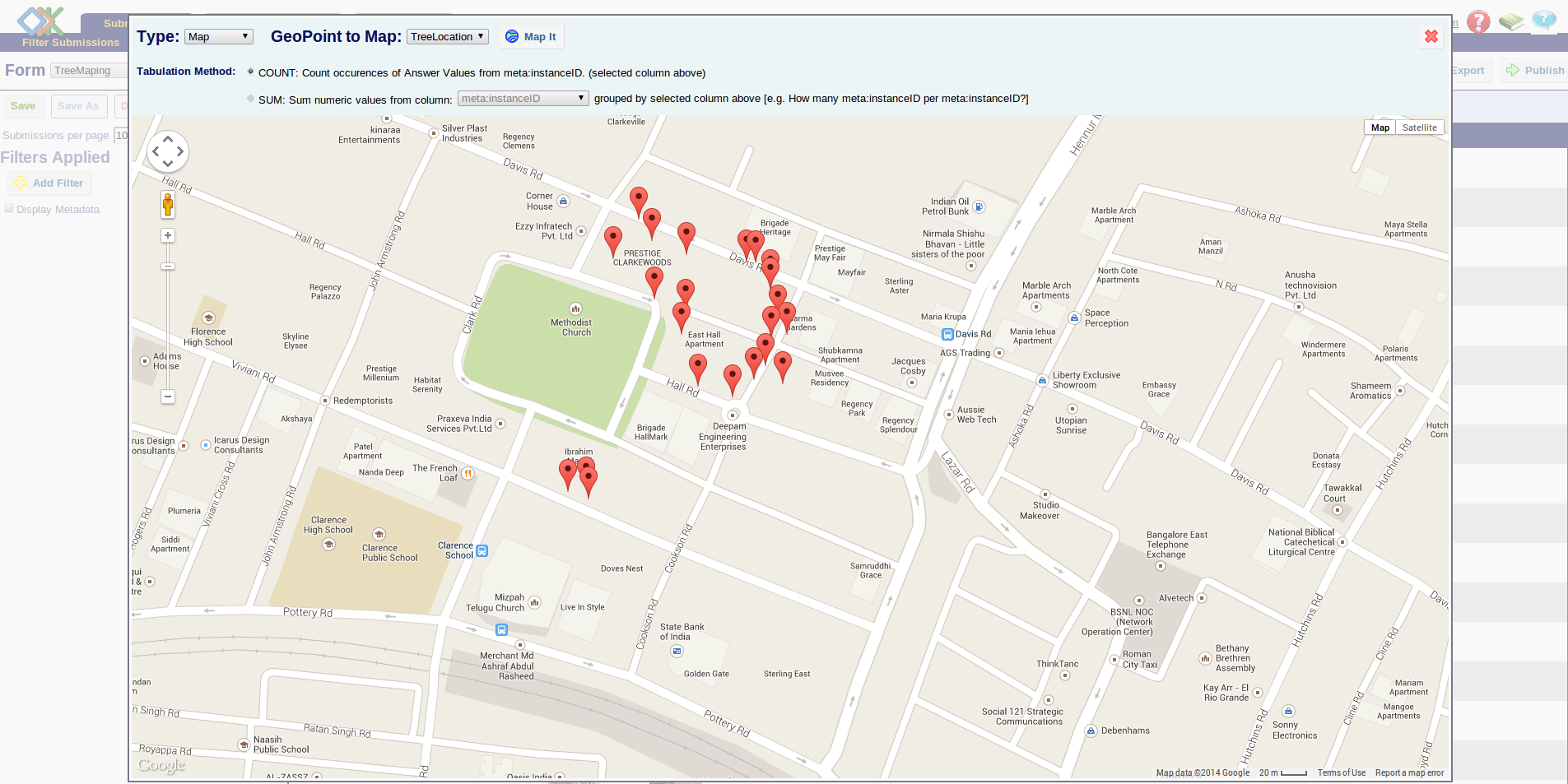
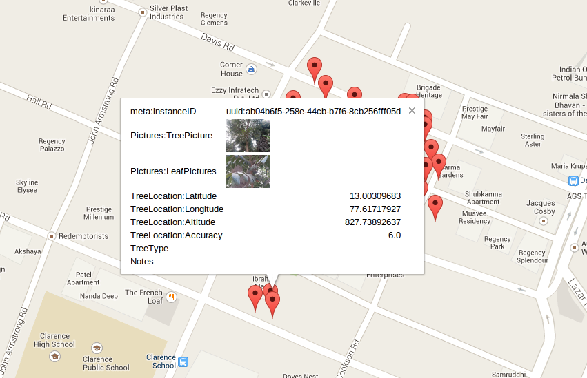
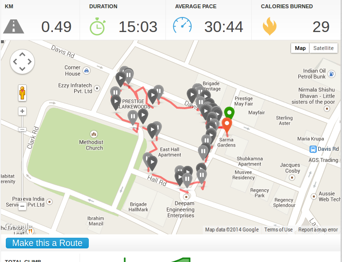
Bangalore, once upon a time called Garden city, still has quite a bit of green cover. Almost every week we read a story about cutting down trees for some reason. But nobody knows the details, including the people who write those articles. I thought it would be great if you had a baseline survey of trees, which can be used for comparing, or many other stories and studies. But imagine mapping every public tree (tress in public areas like road, parks etc) in Bangalore. It will probably take years if I start doing it alone. But then there wa no way to find out other than trying it out. So I asked DataMeet as usual. I figured that a PoC by me would be a great place to begin. Hence I installed ODK on my phone and ODK aggregator on server to collect the survey data. That was easier than I thought. Then this monday I walked around for 15 minutes to survey the trees, in an area which has lots of trees. I mapped around 18 tress in 15 minutes by walking half a kilometer. Some screen shots from the apps
Some issues that I faced
Some ideas, learning and questions |


Gora Mohanty
>
> Thanks a lot Shree. I will get in touch with them.
>
>
> Just to update the group. I did a small POC recently to see if its achievable. I think its quite possible even-though a little difficult.
Yes, ODK is great.
> Some issues that I faced
> 1. GPS logging is not very accurate. It has 4 to 8 meters of error, how do we fix it?
proper GPS fix. Given the quality of the GPS in most phones, a
RMS error of 20m is more realistic. The only way to improve that
is to take a large number of readings, and average over these, but
this cannot be done with ODK out of the box. As the error in the
mean decreases as the square root of the number of observations,
one needs 25 readings to get from 20m to 4m, and 400 to get to
1m. However, if the aim is to identify the general locality, the default
GPS accuracy should be fine.
Regards,
Gora

siddharth hande
Regards,
Gora