India Shape Files
1,735 views
Skip to first unread message

Sutirtha Roy
Jun 13, 2016, 2:03:01 PM6/13/16
to data...@googlegroups.com
Dear everyone: I am not sure if someone in the group has looked at this website: https://ncog.gov.in/garvgis/admin/gisModule.
If one zooms in on the map sufficiently, the website gives district>sub-district>village polygons. I do not have the skills to pull out them out into .shp file but I am hoping that someone in the group might have the time and resources to kindly take a look at it.
Best,
SR

Sharad Lele
Jun 13, 2016, 9:19:41 PM6/13/16
to datameet
Looks like a webGIS platform created by Gujarat State Remote Sensing Agency called BISAG.
It would be wonderful if one could get access to the village layer, especially for Jharkhand, Chhattisgarh, etc. It is visible, but as usually, tightly protected.
Sharad
It would be wonderful if one could get access to the village layer, especially for Jharkhand, Chhattisgarh, etc. It is visible, but as usually, tightly protected.
Sharad

Devdatta Tengshe
Jun 14, 2016, 12:07:50 AM6/14/16
to data...@googlegroups.com
Hi All,
I had looked at this site a few months back, and tried to extract the villages, since it based on a GeoServer Backend.Regards,
Devdatta
--
Datameet is a community of Data Science enthusiasts in India. Know more about us by visiting http://datameet.org
---
You received this message because you are subscribed to the Google Groups "datameet" group.
To unsubscribe from this group and stop receiving emails from it, send an email to datameet+u...@googlegroups.com.
For more options, visit https://groups.google.com/d/optout.

Palash Kulshrestha
Jan 20, 2017, 5:55:57 AM1/20/17
to datameet
Hi Surtirtha, Sharad, Devdatta
I 've extracted all available data of indian subcontinent and stored it in json file https://drive.google.com/file/d/0B8ZjiDWHZ1j-S0taUzRwYmt2NG8/view?usp=sharing
It is till village level. I hope that its put to some use for greater good.
I 've extracted all available data of indian subcontinent and stored it in json file https://drive.google.com/file/d/0B8ZjiDWHZ1j-S0taUzRwYmt2NG8/view?usp=sharing
It is till village level. I hope that its put to some use for greater good.
On Monday, June 13, 2016 at 11:33:01 PM UTC+5:30, Sutirtha wrote:

Thejesh GN
Jan 20, 2017, 6:13:17 AM1/20/17
to data...@googlegroups.com
Seems to have only the following data for each village. Dont know what minx, maxx etc are. Is geo layer stored separately
{"gid":14741,"vilNameSoi":"KAJLA","stateId":"19","distId":"344","subdistId":"02465","villageId":"343022","villageName":"Kajla",
"minx":87.37861784203545,"miny":22.159016472923042,"maxx":87.38472569821403,"maxy":22.162844638588865,"type":"village"}
{"gid":14741,"vilNameSoi":"KAJLA","stateId":"19","distId":"344","subdistId":"02465","villageId":"343022","villageName":"Kajla",
"minx":87.37861784203545,"miny":22.159016472923042,"maxx":87.38472569821403,"maxy":22.162844638588865,"type":"village"}
--
Datameet is a community of Data Science enthusiasts in India. Know more about us by visiting http://datameet.org
---
You received this message because you are subscribed to the Google Groups "datameet" group.
To unsubscribe from this group and stop receiving emails from it, send an email to datameet+unsubscribe@googlegroups.com.
Thejesh GN
Jan 20, 2017, 6:17:04 AM1/20/17
to data...@googlegroups.com
Gives
{"gid":438129,"vilNameSoi":"KAMMASANDRA","stateId":"29","distId":"572","subdistId":"05545","villageId":"613256","villageName":"Kammasandra","minx":77.68262864449315,"miny":12.824103451365033,"maxx":77.69996896356992,"maxy":12.841455112691222}
Then you get the actual layer using

https://ncog.gov.in/garvgis/admin/ows?service=WFS&version=1.0.0&request=GetFeature&typeName=cite:Village2014&PROPERTYNAME=the_geom,VIL_2011,VIL_NAME11&CQL_FILTER=VIL_2011=%27613256%27&maxFeatures=50&outputFormat=json

{"type":"FeatureCollection","totalFeatures":1,"features":[{"type":"Feature","id":"Village2014.438129","geometry":{"type":"MultiPolygon","coordinates":[[[[77.7,12.8348],[77.6995,12.8326],[77.699,12.8305],[77.6983,12.828],[77.6978,12.8262],[77.697,12.8259],[77.6961,12.8255],[77.6951,12.825],[77.6935,12.8243],[77.6929,12.8241],[77.6893,12.8251],[77.6884,12.8253],[77.6871,12.8258],[77.6826,12.8271],[77.6829,12.8288],[77.6841,12.8313],[77.684,12.8333],[77.6838,12.8351],[77.685,12.8374],[77.6856,12.8384],[77.6863,12.84],[77.687,12.8415],[77.6885,12.8394],[77.6896,12.8392],[77.6916,12.8384],[77.6935,12.8379],[77.6954,12.8373],[77.6963,12.8369],[77.697,12.8364],[77.6979,12.8358],[77.6989,12.8351],[77.7,12.8348]]]]},"geometry_name":"the_geom","properties":{"VIL_2011":"613256","VIL_NAME11":"Kammasandra"}}],"crs":{"type":"name","properties":{"name":"urn:ogc:def:crs:EPSG::4326"}}}
Thejesh GN
Jan 20, 2017, 6:24:47 AM1/20/17
to data...@googlegroups.com
@Palash Kulshrestha
Let me know if you downloaded the shapes too.
The accuracy isn't bad for a national level projectLet me know if you downloaded the shapes too.
https://gist.github.com/thejeshgn/2b50ce7fe45287152f55941bd8d76869
Palash Kulshrestha
Jan 20, 2017, 6:34:50 AM1/20/17
to datameet
Hi Thejesh
Thanks for the heads up, I wasn't aware of the underlying architecture which is used in geo systems. So wasn't able to understand the layers data. And now I am able to understand how they come up with polygon on the map. Other wise I was thinking that they somehow came up random shapes using min max x,y.
I'm looking into the new api that you have provided and see what I can come up with. I ll update. Any advice?
To unsubscribe from this group and stop receiving emails from it, send an email to datameet+u...@googlegroups.com.
Thejesh GN
Jan 20, 2017, 7:54:51 AM1/20/17
to data...@googlegroups.com
Imported into mongo to do some initial analysis[1].
Will do some more analysis. > db.states.count()
36
> db.districts.count()
672
> db.taluks.count()
5960
> db.villages.count()
522291
[1] https://gist.github.com/thejeshgn/ea0074077b6fcd6c0108b2a4380fc354
To unsubscribe from this group and stop receiving emails from it, send an email to datameet+unsubscribe@googlegroups.com.
Palash Kulshrestha
Jan 21, 2017, 4:38:30 AM1/21/17
to datameet
With more than 5 lakh villages, it seems like feature data is going to take lot of time owing to the fact that the features api is pretty heavy on their system. will update.
@ThejeshGN I features hope data is useful?
@ThejeshGN I features hope data is useful?

Seetharaman N
May 10, 2018, 9:49:35 AM5/10/18
to datameet
This is great !! Thanks much
I have this constant difficulty of finding data on this UT of Pondicherry - it somehow gets lost among all the big-brother states ... lol
Would be much helpful if you can point me where to look, among all those extracted json files
Thanks
Sharad Lele
May 11, 2018, 4:18:40 AM5/11/18
to datameet
Hi Thejesh:
Sharad
Did you ever manage to convert the data into a polygon file? I could not follow the technical intricacies of what you were discussing with Palash, but certainly the original json file posted by him did not contain the polygons and could not be imported into QGIS. Do you now have one which can be? And is it good quality?
Sharad

Arun Ganesh
Oct 28, 2018, 2:28:17 AM10/28/18
to data...@googlegroups.com
The various village/taluk shapefile layers are available in the Bhuvan GeoServer layer listing:
Search for 'vill' for village boundaries by state. Search for 'taluk' for all taluk boundaries. Note that the page gives a timeout error if you take more than a few seconds and you need to start over. Since WFS export is disabled, you can use the GeoRSS option to download the shape.
The one issue is that the attributes are encoded as an html string and needs to be parsed out. Nikhil has a great python script to do this: https://github.com/answerquest/asi-monuments-xml2csv/blob/master/asi-monuments2.ipynb but needs to be customized for each layer.
Arun Ganesh
Oct 28, 2018, 2:42:13 AM10/28/18
to data...@googlegroups.com
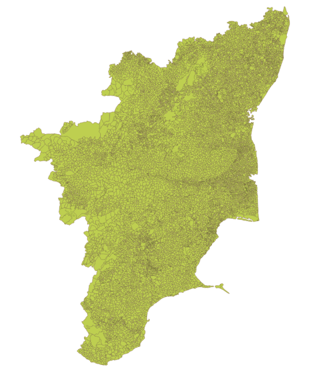
Tamil Nadu villages. Has 17,693 features as against census count of 15243 villages+1097 towns = 16340 in census 2011. Is this is the same as the India Village boundaries? http://projects.datameet.org/indian_village_boundaries/
Sharad Lele (शरच्चंद्र लेले)
Oct 28, 2018, 2:47:59 AM10/28/18
to data...@googlegroups.com, Arun Ganesh
Dear Arun:
Can you help me understand this by downloading, processing attributes, and sharing the village layer for one state--say Madhya Pradesh?
I may be asking too much, but in fact if this method for
downloading village shapefiles from Bhuvan is feasible, it would
be great to complete the repository of village boundary shapefiles
started by Thejesh and other datameet folks.
Sharad
You received this message because you are subscribed to a topic in the Google Groups "datameet" group.
To unsubscribe from this topic, visit https://groups.google.com/d/topic/datameet/XTF4_P-nxU8/unsubscribe.
To unsubscribe from this group and all its topics, send an email to datameet+u...@googlegroups.com.
Devdatta Tengshe
Oct 28, 2018, 5:00:12 AM10/28/18
to data...@googlegroups.com
Hi Arun,
I wrote a simple script for converting this GeoRSS to GeoJSON, along with the attributes.
Do check it out and let me know.
Regards,
Devdatta
On Sun, Oct 28, 2018 at 11:58 AM Arun Ganesh <arung...@gmail.com> wrote:
Devdatta Tengshe
Oct 28, 2018, 5:05:29 AM10/28/18
to data...@googlegroups.com
Hi Arun,
One of the issues I found with the GeoRSS format is that it does not support Multi-part features and has a new item for each part. Hence there could be more features due to this. You could do a distinct query on 'link' attribute to get count of unique villages.
Regards,
Devdatta
Sharad Lele (शरच्चंद्र लेले)
Oct 28, 2018, 6:18:25 AM10/28/18
to data...@googlegroups.com, Devdatta Tengshe
Dear Arun, Devadutta and others:
Sharad
You received this message because you are subscribed to a topic in the Google Groups "datameet" group.
To unsubscribe from this topic, visit https://groups.google.com/d/topic/datameet/XTF4_P-nxU8/unsubscribe.
To unsubscribe from this group and all its topics, send an email to datameet+u...@googlegroups.com.
Arun Ganesh
Oct 29, 2018, 2:58:01 AM10/29/18
to data...@googlegroups.com
Wow, thank you Devdatta. Having mixed success with the script, works on some of the files but not all. I'll investigate more an open issues comparing it with the script Nikhil shared https://github.com/answerquest/asi-monuments-xml2csv/blob/master/asi-monuments2.ipynb
Sharad Lele
Oct 29, 2018, 3:09:30 AM10/29/18
to data...@googlegroups.com
What about the ID issue? if we don't solve that, how do you folks propose to make use of this layer? we cannot even get village names without having Census 2011 ids in there...
You received this message because you are subscribed to a topic in the Google Groups "datameet" group.
To unsubscribe from this topic, visit https://groups.google.com/d/topic/datameet/XTF4_P-nxU8/unsubscribe.
To unsubscribe from this group and all its topics, send an email to datameet+u...@googlegroups.com.
Arun Ganesh
Oct 30, 2018, 1:41:55 PM10/30/18
to data...@googlegroups.com
Wow, thank you Devdatta. Having mixed success with the script, works on some of the files but not all. I'll investigate more an open issues comparing it with the script Nikhil shared https://github.com/answerquest/asi-monuments-xml2csv/blob/master/asi-monuments2.ipynb
While trying to play with the code, I ended up writing a PyQGIS script (my first!) that can be run within QGIS and seems to work on all the GeoRSS files downloaded from Bhuvan.
Uploaded here https://github.com/planemad/qgis-extract-html-attributes
On Mon, Oct 29, 2018 at 12:39 PM Sharad Lele <shara...@gmail.com> wrote:
What about the ID issue? if we don't solve that, how do you folks propose to make use of this layer? we cannot even get village names without having Census 2011 ids in there...
The ids are definitely strange. One way is maybe to join them using the name from the Census codes?
Arun Ganesh
Oct 31, 2018, 5:45:55 PM10/31/18
to data...@googlegroups.com
What about the ID issue? if we don't solve that, how do you folks propose to make use of this layer? we cannot even get village names without having Census 2011 ids in there...The ids are definitely strange. One way is maybe to join them using the name from the Census codes?
Found another set of shapefiles that have the correct village code, but available only for 20 states. Search for 'vill_percent' in http://bhuvannuis.nrsc.gov.in/bhuvan/web/?wicket:bookmarkablePage=:org.geoserver.web.demo.MapPreviewPage

Sashikumar N
Nov 5, 2018, 1:40:17 AM11/5/18
to datameet
Hi Arun,
Thanks for the cool PyQGIS code, it works like a breeze for points and lines, but it gives a error for polygon layers. Just wanted to give this as a feedback. So glad that you, Nikhil, Devdatta and others are contributing voluntarily for the efforts to read bhuvan GeoRSS layers. In our country it's the only way to get access to the locked away datasets!, wish it was not this way and Govt come forward to give the public data.
Here is another link for more bhuvan georss datasets, this page also timeouts after few seconds
This does have a layer for Karnataka Village census (search for Kar_vill_cens), i have not checked for other states. But since its a polygon layer, the code is not working to separate the attributes.
On a different topic, as a group can we make effort to download and archive this and other layers available now?(don't know the legal implications) I wonder how long it will be allowed. Its too big for few people to download all of them. We can make a effort to download state wise with volunteers who can download and collate it later.
wishing everyone a nice day
regards
sashi

Naveen Francis
Nov 5, 2018, 3:43:10 PM11/5/18
to datameet
Which applies we have to ask lawyers.
HERE already acknowledges data.gov.in
--
naveenpf

Nitin Sathe
Nov 7, 2018, 10:53:31 AM11/7/18
to data...@googlegroups.com
thanks

Susanta Mahato
Nov 24, 2018, 1:19:02 PM11/24/18
to data...@googlegroups.com
?? Can anyone have ward shapefile of Kochi and Surat

S.Rashmita Patro
Aug 5, 2019, 8:20:45 AM8/5/19
to data...@googlegroups.com
Hi All,
I am trying to access the http://bhuvannuis.nrsc.gov.in/bhuvan/web/?wicket:bookmarkablePage=:org.geoserver.web.demo.MapPreviewPage link and its not working.
Any suggestions?
Best,
S Rashmita Patro
On Sun, Oct 28, 2018 at 11:58 AM Arun Ganesh <arung...@gmail.com> wrote:

Sridhar
Aug 5, 2019, 11:36:21 PM8/5/19
to datameet
bhuvannuis.nrsc.gov.in : There is no domain with this name or it is not publicly accessible.
To unsubscribe from this group and stop receiving emails from it, send an email to data...@googlegroups.com.
For more options, visit https://groups.google.com/d/optout.
--
Datameet is a community of Data Science enthusiasts in India. Know more about us by visiting http://datameet.org
---
You received this message because you are subscribed to the Google Groups "datameet" group.
To unsubscribe from this group and stop receiving emails from it, send an email to data...@googlegroups.com.

Arjuna Rao Chavala
Aug 9, 2019, 9:54:48 AM8/9/19
to datameet
Hi Sridhar,
bhuvannuis.nrsc.gov.in : There is no domain with this name or it is not publicly accessible.
Sharad Lele
Aug 9, 2019, 10:40:49 AM8/9/19
to data...@googlegroups.com
Arjuna and others: These are layers that one can view via GoogleEarth, but not really downloadable right? Like I tried to look at the Kodagu lulc layer. Seems reasonably accurate. But don't know the year or the legend. Where would this info be? and is there a way to download the layer as a shapefile?
You received this message because you are subscribed to a topic in the Google Groups "datameet" group.
To unsubscribe from this topic, visit https://groups.google.com/d/topic/datameet/XTF4_P-nxU8/unsubscribe.
To unsubscribe from this group and all its topics, send an email to datameet+u...@googlegroups.com.
To view this discussion on the web visit https://groups.google.com/d/msgid/datameet/dfa55908-f2b4-44d1-a554-c39d28a6643f%40googlegroups.com.
Arun Ganesh
Aug 10, 2019, 8:24:20 AM8/10/19
to datameet
On Fri, Aug 9, 2019 at 8:10 PM Sharad Lele <shara...@gmail.com> wrote:
Arjuna and others: These are layers that one can view via GoogleEarth, but not really downloadable right? Like I tried to look at the Kodagu lulc layer. Seems reasonably accurate. But don't know the year or the legend. Where would this info be? and is there a way to download the layer as a shapefile?
They have disabled the WFS protocol which would allow a direct shapefile download. There is a workaround and you can try the GeoRSS option to download it as an XML that will open in QGIS and then use this python script in QGIS console to extract the attributes from the XML fields: https://github.com/planemad/qgis-extract-html-attributes/blob/master/extract_html_attributes.py

Sabyasachi Kabiraj
Aug 13, 2019, 12:51:17 AM8/13/19
to data...@googlegroups.com
Is it possible to download shape file from bhuvan website?
...............................................................................................................
Sabyasachi Kabiraj
Senior Research Fellow
Central Institute of Brackishwater Aquaculture (ICAR-CIBA)
Santhome, Chennai- 28
Tamil Nadu, India
Contact No.: +91-7384774928, 8250259808
--
Datameet is a community of Data Science enthusiasts in India. Know more about us by visiting http://datameet.org
---
You received this message because you are subscribed to the Google Groups "datameet" group.
To unsubscribe from this group and stop receiving emails from it, send an email to datameet+u...@googlegroups.com.
To view this discussion on the web visit https://groups.google.com/d/msgid/datameet/CA%2BGKQr3YiTZ99q%3DUVfuJHbP%2BJ27CN0Ms%3D457orJNTgrndcVpUg%40mail.gmail.com.

Prabhakar Rajagopal
Aug 14, 2019, 8:22:52 AM8/14/19
to data...@googlegroups.com
You can download pixels of the lulc and a raster from GEE and use it for analysis.
Prabhakar
--
Datameet is a community of Data Science enthusiasts in India. Know more about us by visiting http://datameet.org
---
You received this message because you are subscribed to the Google Groups "datameet" group.
To unsubscribe from this group and stop receiving emails from it, send an email to datameet+u...@googlegroups.com.
To view this discussion on the web visit https://groups.google.com/d/msgid/datameet/CA%2BGKQr3YiTZ99q%3DUVfuJHbP%2BJ27CN0Ms%3D457orJNTgrndcVpUg%40mail.gmail.com.
Reply all
Reply to author
Forward
0 new messages