India WRIS - Web Map Services
796 views
Skip to first unread message

Thejesh GN
Aug 17, 2016, 4:06:58 PM8/17/16
to data...@googlegroups.com
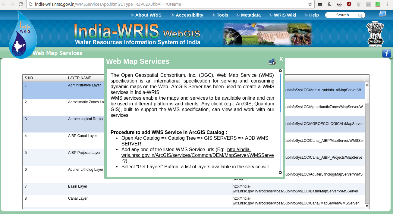
They publicly suggest using these WMS services. Any one has tried? How is the quality of Administrative Layer

Arun Ganesh
Aug 17, 2016, 4:17:19 PM8/17/16
to datameet
It has village boundaries (2001) and district boundaries (2001 and 2011) which could be of use.Seems accurate to the order of around 0.5km, the district boundaries definitely seem more precise than whats currently in OSM.
--
Datameet is a community of Data Science enthusiasts in India. Know more about us by visiting http://datameet.org
---
You received this message because you are subscribed to the Google Groups "datameet" group.
To unsubscribe from this group and stop receiving emails from it, send an email to datameet+unsubscribe@googlegroups.com.
For more options, visit https://groups.google.com/d/optout.
Arun Ganesh
Thejesh GN
Aug 17, 2016, 5:12:46 PM8/17/16
to data...@googlegroups.com
Thanks Arun.
There seems to be a separate Rural Service which serves villages
It looks great. I will keep the list updated.

Justin Meyers
Aug 18, 2016, 10:34:05 AM8/18/16
to datameet
the data is off; heavily generalized. I am not sure if this can be published/ redistributed? see attachment - I have it all downloaded in shapefile format if needed.
I think it comes back to the magical question: can data be scraped, then published/ redistributed? Thats basically what we are left to do - the SOI doesn't know how to respond to emails, does not acknowledge RTIs - https://data.gov.in/ publishes tons of data, but most of it is junk. when asking for geospatial data they point in the direction of several garbage WMSs.
So I have to assume you guys, on the ground in India (*and the MapBox guys/ girls) to be the subject matter experts - you deal with this more than anyone else.
Can data be scraped and redistributed? If so, I have it done. have had it done for months/ years. I will gladly post it on my blog and github. But no-one has really answered that question. I tried to ask, ask directly, but you aren't responding: https://groups.google.com/forum/#!searchin/datameet/village%7Csort:date/datameet/S9Xr1a5pcmM/flR9m4BODQAJ
On Wednesday, August 17, 2016 at 5:12:46 PM UTC-4, Thejesh GN wrote:
Thanks Arun.There seems to be a separate Rural Service which serves villagesIt looks great. I will keep the list updated.
On 18 August 2016 at 01:46, Arun Ganesh <arung...@gmail.com> wrote:
It has village boundaries (2001) and district boundaries (2001 and 2011) which could be of use.Seems accurate to the order of around 0.5km, the district boundaries definitely seem more precise than whats currently in OSM.
On Thu, Aug 18, 2016 at 1:36 AM, Thejesh GN <i...@thejeshgn.com> wrote:
They publicly suggest using these WMS services. Any one has tried? How is the quality of Administrative Layer
--
Datameet is a community of Data Science enthusiasts in India. Know more about us by visiting http://datameet.org
---
You received this message because you are subscribed to the Google Groups "datameet" group.
To unsubscribe from this group and stop receiving emails from it, send an email to datameet+u...@googlegroups.com.
For more options, visit https://groups.google.com/d/optout.
--Arun Ganesh
--
Datameet is a community of Data Science enthusiasts in India. Know more about us by visiting http://datameet.org
---
You received this message because you are subscribed to the Google Groups "datameet" group.
To unsubscribe from this group and stop receiving emails from it, send an email to datameet+u...@googlegroups.com.
Thejesh GN
Aug 18, 2016, 11:23:09 AM8/18/16
to data...@googlegroups.com
Did you read Nisha's reply on this thread.
https://groups.google.com/forum/m/#!topic/datameet/YSmUGsPy38A
To unsubscribe from this group and stop receiving emails from it, send an email to datameet+unsubscribe@googlegroups.com.
Justin Meyers
Aug 18, 2016, 12:35:08 PM8/18/16
to datameet
Thanks for the response - just read it. I try to post data to my blog and github, but only when the license is clear - India is a grey area. They don't answer emails. So you are just assuming it is okay to publish the scraped data? You did this years ago: https://archive.org/details/IndiaVillageBoundaries
Can anyone call the soi in their state and ask them? or could we get a written letter? Maybe by asking them for the data instead of scraping it, we would get a more current dataset, will all levels and attributes.
Just my thoughts

Craig Dsouza
Aug 18, 2016, 3:19:24 PM8/18/16
to datameet
Hi Thej, Arun
I use the WRIS WMS for the rivers layer and command areas of irrigation projects layer.
Both are fairly accurate. I've been able to find smaller streams, named in government documents (environmental clearances) which can't be found on google/osm.
So in that sense they're usable.
In fact I'm toying with the idea of editing osm waterways to resemble the rivers WMS available on WRIS.
Arun, what do you think, since you've done a lot of editing of rivers on OSM already?
Best
Craig
Arun Ganesh
Aug 18, 2016, 3:32:39 PM8/18/16
to datameet
In fact I'm toying with the idea of editing osm waterways to resemble the rivers WMS available on WRIS.Arun, what do you think, since you've done a lot of editing of rivers on OSM already?
Does not seem like WRIS can be used as an ODbL compatible source to trace directly into OSM. It should be ok if you want to use WRIS as a reference but then trace off Bing satellite imagery, which should be accurate upto a few metres.
Can you share an example location where OSM was not as accurate as the WRIS layer?
BestCraig
On Thursday, August 18, 2016 at 1:36:58 AM UTC+5:30, Thejesh GN wrote:They publicly suggest using these WMS services. Any one has tried? How is the quality of Administrative Layer
--
Datameet is a community of Data Science enthusiasts in India. Know more about us by visiting http://datameet.org
---
You received this message because you are subscribed to the Google Groups "datameet" group.
To unsubscribe from this group and stop receiving emails from it, send an email to datameet+unsubscribe@googlegroups.com.
For more options, visit https://groups.google.com/d/optout.
Craig Dsouza
Aug 19, 2016, 3:00:31 AM8/19/16
to datameet
Yes I guess like all other data put out there licensing is a question mark. For tracing rivers I could do it off Bing imagery but with command areas imagery wouldn't help much.
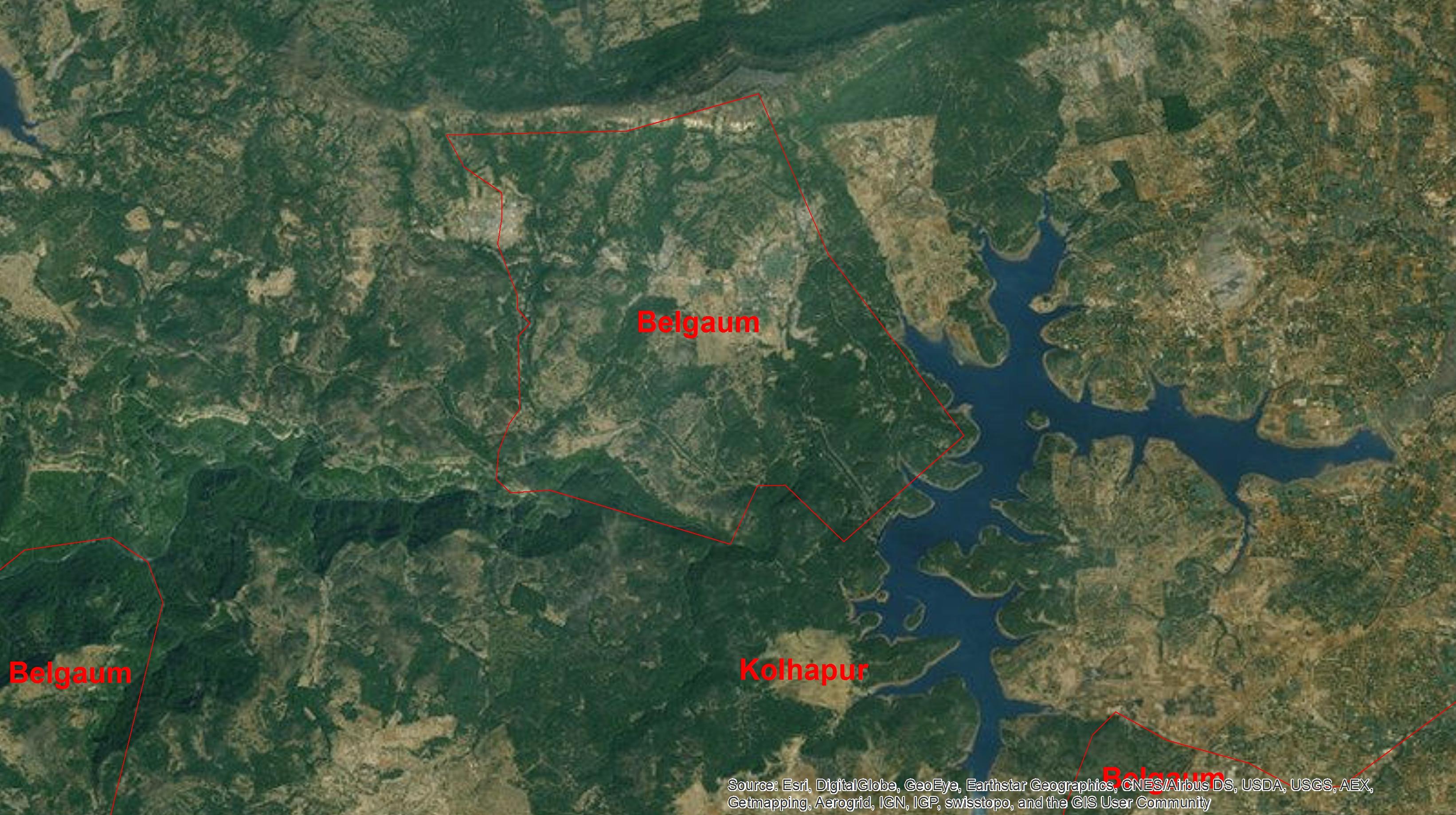
wrt accuracy of OSM vs WRIS see the attached screenshot, this is the Hasdeo river in Chhattisgarh where we're doing some hydrological studies. What we need for these is an accurate idea of the size of watersheds and the rivers/streams within, so that we can simulate flows and calibrate the readings with official flows data we receive from the government.
In the image, you can see that some rivers/streams are missing in the OSM map, especially in the upper catchment areas where river lines are smaller and harder to trace. To sum up the issues i think could be rectified,
- missing or partially complete rivers/streams
- missing names (ideally we would want to give them the official government names as per WRIS)
- joining broken river/stream segments
- ensuring topological info with appropriate attributes, for example if I want to filter out just a single river and all its tributaries there should be an automated way to do this. We would have to create attributes that assign every segment as a tributary of some larger river. Can we brainstorm on how to do this?
I want to work on this, but also document the process so if others pitch in the data standards are maintained.
To unsubscribe from this group and stop receiving emails from it, send an email to datameet+u...@googlegroups.com.
Reply all
Reply to author
Forward
0 new messages