Bangalore Constituency / Ward map
1,750 views
Skip to first unread message

Parag Sarda
Jan 13, 2014, 3:50:35 AM1/13/14
to data...@googlegroups.com
Hello Data Enthusiast,
I am looking for open and free data which maps Bangalore Constituencies. Something like KML file which I can impose on Google Maps.
Does anyone who if such data exists ?
PS: Data is available at http://openbangalore.org/available-data/ but its old and wards boundaries etc have changed since then.
Thanks,
Parag

Devdatta Tengshe
Jan 13, 2014, 8:30:32 AM1/13/14
to data...@googlegroups.com
What constituencies are you looking for? Assembly constituencies? or Municipal Constituencies?
Regards,
Devdatta Tengshe

Ajay Kelkar
Jan 14, 2014, 2:08:45 AM1/14/14
to data...@googlegroups.com
Hi
I run an analytics company & we do a lot of work with many industries. The struggle constantly is to "tell stories with data". Analysts are good at analyzing & often they struggle with visualizing & telling their story.We are also working with an NGO & doing analytics for them where we need "stories" to be told from the data for front end people.I was keen to talk to people who could do visualization projects with us & also share ideas & thoughts.
--
For more details about this list
http://datameet.org/discussions/
---
You received this message because you are subscribed to the Google Groups "datameet" group.
To unsubscribe from this group and stop receiving emails from it, send an email to datameet+u...@googlegroups.com.
For more options, visit https://groups.google.com/groups/opt_out.

Gautam John
Jan 14, 2014, 2:11:14 AM1/14/14
to datameet

Sharad Lele
Jul 22, 2014, 1:29:22 AM7/22/14
to data...@googlegroups.com
I thought I would post here rather than open a new thread, even if this thread is old.
I am looking for ward boundaries of Bangalore Municipal Corporation PRIOR to the creation of BBMP. Because I am trying to link Census 2001 and Census 1991 data to ward boundaries to estimate population densities and how they changed over time.
So does anyone know where I can get a reasonable quality map (even pdf/jpg) of BMP ward boundaries of 2001?
Sharad

chava jyothi
Sep 5, 2014, 11:55:06 AM9/5/14
to data...@googlegroups.com
Hi Sharad,
This is jyothi, I'm doing my PhD in Bangalore
I'm also looking for Bangalore dist ward boundaries as per 2001 census statistics. Actually I'm trying to compare the 2011 census data with 2001 census data. but ward numbers are not matching. It would be very useful if the 2001 boundary map is available.
Please do let me know, if you know anay availability of such maps
Jyothi

H. S. Sudhira
Sep 5, 2014, 9:29:40 PM9/5/14
to data...@googlegroups.com
Hi Sharad,
Here it is erstwhile BMP with 100 wards. This is something I managed when I was interning with BMP.
Thejesh, please feel free to add under OpenBangalore repo.
Best,
Sudhira.
--
Datameet is a community of Data Science enthusiasts in India. Know more about us by visiting http://datameet.org
---
You received this message because you are subscribed to the Google Groups "datameet" group.
To unsubscribe from this group and stop receiving emails from it, send an email to datameet+u...@googlegroups.com.
For more options, visit https://groups.google.com/d/optout.
"Sharad Lele [शरच्चंद्र लेले]"
Sep 6, 2014, 1:01:33 PM9/6/14
to data...@googlegroups.com
Dear Sudhira:
Thanks for this. A small query: have you checked how this BMP layer sits on Google Earth? Seems to me that it is about 400m shifted to the southeast. See screenshot, where I have also overlaid my layer for BBMP (not BMP) wards. (And I think the BBMP layer is sitting correctly, because it follows prominent roads.
Sharad
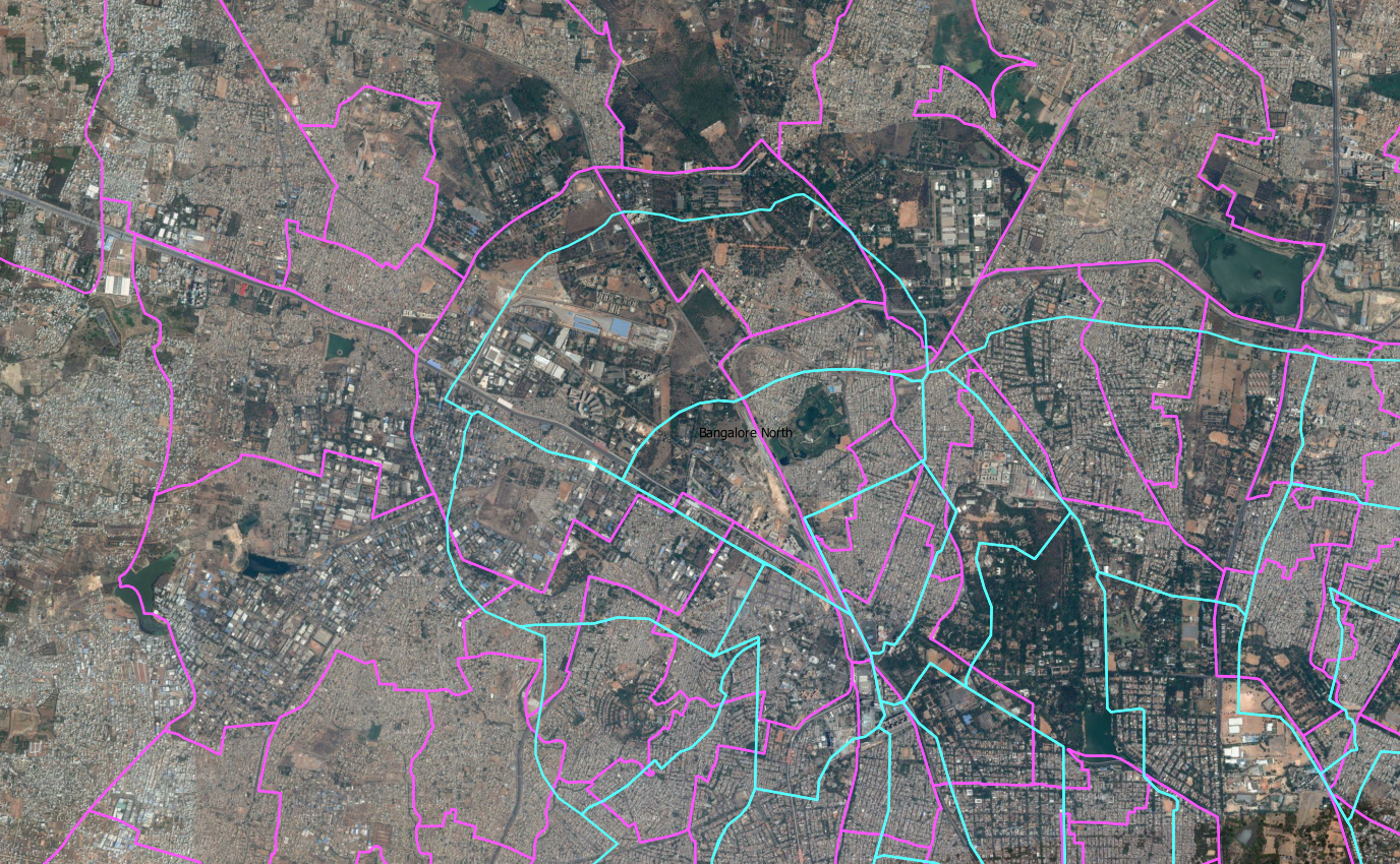
You received this message because you are subscribed to a topic in the Google Groups "datameet" group.
To unsubscribe from this topic, visit https://groups.google.com/d/topic/datameet/3K1jF2806hg/unsubscribe.
To unsubscribe from this group and all its topics, send an email to datameet+u...@googlegroups.com.
For more options, visit https://groups.google.com/d/optout.
--
Democratizing Forest Governance in India
(In press with Oxford University Press India)
Jyothi Chava
Sep 6, 2014, 5:45:21 PM9/6/14
to data...@googlegroups.com
Hi Sudhira
Thanks for such a quick reply. Its very useful
.
Jyothi chava
You received this message because you are subscribed to a topic in the Google Groups "datameet" group.
To unsubscribe from this topic, visit https://groups.google.com/d/topic/datameet/3K1jF2806hg/unsubscribe.
To unsubscribe from this group and all its topics, send an email to datameet+u...@googlegroups.com.
--
With Regards
Jyothi Chava
Jyothi Chava
Doctoral student
CUSP, Curtin University
WA

Thejesh GN
Sep 15, 2014, 9:48:01 AM9/15/14
to data...@googlegroups.com
I have uploaded the same to Archive.org
Will link from the catalog and openbangalore
Sharad Lele
Mar 22, 2018, 8:19:26 AM3/22/18
to datameet
Bringing up an old thread: BBMP ward boundaries
Has anyone compared the boundaries now available in OpenCity (http://data.opencity.in/Data/BBMP-Wards.kml) with the maps on Github (either https://github.com/openbangalore/bangalore/tree/master/bangalore/GIS/bbmpwards, or at https://github.com/datameet/Municipal_Spatial_Data/tree/master/Bangalore)?
I tried to compare with a BBMP wardboundary layer i had, and I think the OpenCity version is more accurate/uptodate. But for the life of me, I could not load the abovementioned github files (geojson or shp or kml) in my QGIS. Says invalid file.
Sharad

Nishadh K A
Mar 23, 2018, 12:28:27 AM3/23/18
to datameet
This is for cross checking, layers from https://github.com/datameet/Municipal_Spatial_Data/tree/master/Bangalore and https://github.com/openbangalore/bangalore/tree/master/bangalore/GIS/bbmpwards downloaded and it is opened in QGIS, all the layers(including http://data.opencity.in/Data/BBMP-Wards.kml) are aligning perfectly in overlay and has 198 ward polygons in all of it. The screen shot is attached here with.
Devdatta Tengshe
Mar 23, 2018, 12:31:14 AM3/23/18
to data...@googlegroups.com
It should be noted that the data in the Datameet/Municipal Repo, is an copy of the Data in the OpenBangalore Repo. It has even been mentioned in the Readme: https://github.com/datameet/Municipal_Spatial_Data/tree/master/Bangalore
Regards,
Devdatta
On Fri, Mar 23, 2018 at 9:58 AM, Nishadh K A <nish...@gmail.com> wrote:
This is for cross checking, layers from https://github.com/datameet/Municipal_Spatial_Data/tree/master/Bangalore and https://github.com/openbangalore/bangalore/tree/master/bangalore/GIS/bbmpwards downloaded and it is opened in QGIS, all the layers(including http://data.opencity.in/Data/BBMP-Wards.kml) are aligning perfectly in overlay and has 198 ward polygons in all of it. The screen shot is attached here with.
--
Datameet is a community of Data Science enthusiasts in India. Know more about us by visiting http://datameet.org
---
You received this message because you are subscribed to the Google Groups "datameet" group.
To unsubscribe from this group and stop receiving emails from it, send an email to datameet+unsubscribe@googlegroups.com.
Reply all
Reply to author
Forward
0 new messages