Coburg Ridge this weekend.

David Le
We're meeting at 9 am, Mohawk General Store, in Mohawk Oregon.

Eric Miller
Our club needs a good thermic summer site. A few of us are headed to Coburg Ridge, near Coburg, Oregon, this Saturday and Sunday. Our president, Steve Carpentier, scoped this area and it looks promising. Going to camp, clear a launch, and check it out.
We're meeting at 9 am, Mohawk General Store, in Mohawk Oregon.
--
You received this message because you are subscribed to the Google Groups "Cascade Paragliding Club" group.
To unsubscribe from this group and stop receiving emails from it, send an email to cpcl+uns...@googlegroups.com.
To view this discussion on the web visit https://groups.google.com/d/msgid/cpcl/c51f4f37-d522-4e78-b92d-b7b717e78315%40googlegroups.com.

Mike Steed
Sent: Thursday, July 18, 2019 7:55 PM
To: David Le <asians...@gmail.com>
Cc: Cascade Paragliding Club <cp...@googlegroups.com>
Subject: Re: CPC: Coburg Ridge this weekend.
David Le

Jens Peterson
To view this discussion on the web visit https://groups.google.com/d/msgid/cpcl/CAARj2DJeF_75v%2B%3DVnAbEi3BEJyH4SigLGF7cQwZVfR4DuV_FHQ%40mail.gmail.com.
<image.png>
David Le

Steve Carpentier
To view this discussion on the web visit https://groups.google.com/d/msgid/cpcl/896914AA-B0AC-4898-9780-DC0370C25D09%40gmail.com.

Bill Briskey
To view this discussion on the web visit https://groups.google.com/d/msgid/cpcl/CAHrJWwof6EEt_%3Ds4stGi4nu%3D46N6sxrB%2BWx6yy%2BGsURgxpR8%2BQ%40mail.gmail.com.
Bill Briskey
Our club needs a good thermic summer site. A few of us are headed to Coburg Ridge, near Coburg, Oregon, this Saturday and Sunday. Our president, Steve Carpentier, scoped this area and it looks promising. Going to camp, clear a launch, and check it out.
We're meeting at 9 am, Mohawk General Store, in Mohawk Oregon.
--
You received this message because you are subscribed to the Google Groups "Cascade Paragliding Club" group.
To unsubscribe from this group and stop receiving emails from it, send an email to cpcl+uns...@googlegroups.com.
To view this discussion on the web visit https://groups.google.com/d/msgid/cpcl/c51f4f37-d522-4e78-b92d-b7b717e78315%40googlegroups.com.

Dirk Larson
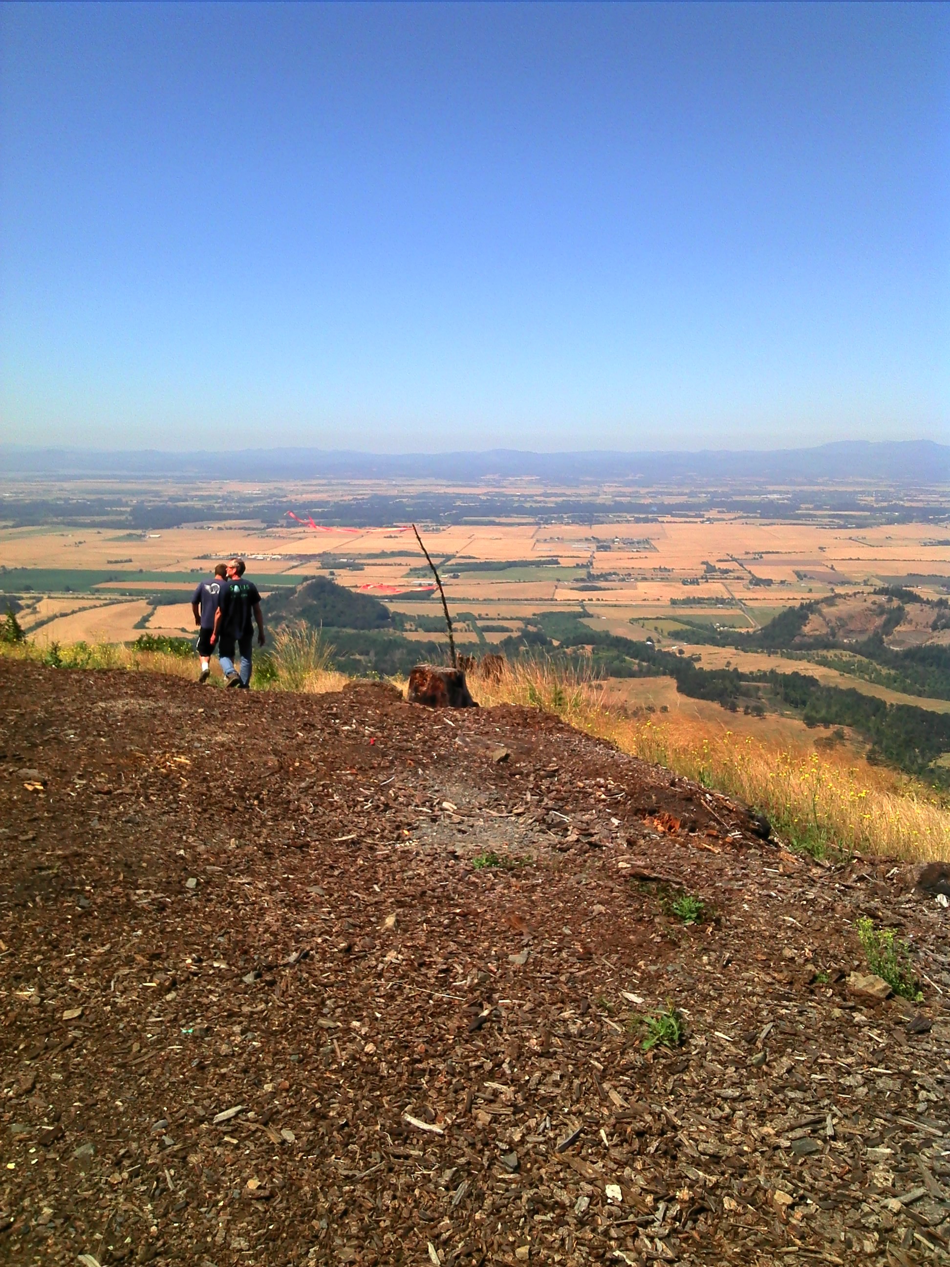
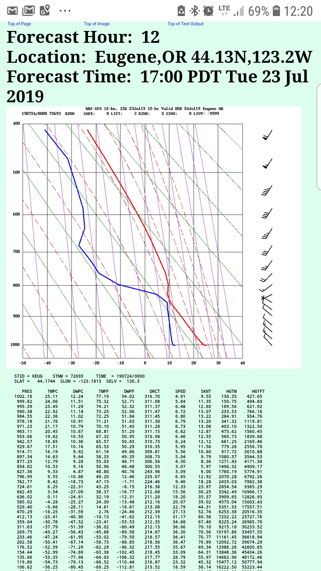
The CPC gang explored Coburg ridge today, and there were at least ten in attendance. Three flew - me, Kevin, and Big Nick. It was thermic for sure, although mostly bubbles - lots of them. So the experience was like you were in a swing set - lift, sink, lift, sink, repeat. We had no problems staying up and I logged two hours before we all landed next to the freeway in harvested grass fields. Some observations from my perspective -The first one off the ground was President Steve, although he was kiting and got popped up a few feet. Therefore I propose that the site be named "Carpentier Popper" or something of that nature. Besides, it was Steve who got everyone fired up to try it!This location is a 20 minute drive from the town of Mowhawk. It is a good thermal site, and favors NW-W wind. We launched in NNW and it was good to have others around to help fluff, as there was additional turbulence from the hillside since it was cross and it took a few cycles for us all to get off safely. Depending on who's GPS you use, launch is at about 2500 feet. Top of lift for me was 3500. The freeway is 3 miles west via crow. The LZ below launch is very friendly, although a gate means an easy 1.5 mile hike out to the main road. We were happy to not have to hike. There is another valley due west that has plenty of open space to land. Lots of options, and definitely not a concern for taking a sledder except the long drive to get you. Steve says there are other launches for all other wind directions, so we'll have to do some more exploring.At one point I tried to work my way upwind around a corner to check out another bowl to see if we could use it. During my journey a nasty confluence came my way and I experienced a 50% collapse. It started me into a slow spiral and when the wing re-inflated, I still had a cravat. I was surprised that the cravat was turning me so I leaned the opposite way and used a little opposite brake to stop the turn. I was plenty high so I wasn't worried about maintaining a specific direction, and that contributed to my lack of initial response to the turn and could have been uglier if I was on a higher-performing wing instead of my new Rush 5. Once flying straight, I attended to the cravat by yarding in the stabilo. This didn't work at first but a second time combined with some quick brake pumping input finally popped it out. (The ears don't come out once I pull them on this glider unless I pump brakes, so this felt similar.) At the time I didn't think of it, but I probably would have had the cravat out a lot sooner if I had forced a quick spiral to build up more pressure in the other side of the wing and then braked/leaned on the outside to stop it, a trick I learned from an SIV class with Brad Gunnuccio. Since I had done a couple SIVs, the pucker factor wasn't extreme, and I was more irritated that I had lost a couple hundred feet with all the fooling around and had to turn back toward launch to tank up again, AND I was in a big pocket of sink. I decided that conditions had changed enough in the wrong direction (it was after 2pm) and it was time to get grounded, so I tanked up over launch and headed west.The valley winds were strong once we got down to around 1200 feet and when mixed with the thermal activity made for an interesting landing experience. This was definitely one of those situations that is far closer to becoming an issue but doesn't - so you walk away not really knowing that the odds were not actually in your favor. This is the risk we assume when we fly in these conditions. XC pilots either know this or are fooling themselves. Anyway, I watched Kevin parked for a period of about two minutes at about 20 feet off the ground before the lift allowed him to land safely, and I found out later that he was on full bar during those minutes and held it clear to the ground. But once he touched down he brought his wing down with no issues. I then kept hitting thermal bubbles and so pulled ears and pushed bar to load the wing and stay in position. I got rocked a bit, but the wing was stable with more pressure on less fabric. At about 50 feet I got off bar and ears and then pumped brakes to get the ears out because I was still sinking fast, then came to a nice stand-up landing with no issues.We packed up in the shade and walked out just perfectly timed to meet our chase cars with smiles and congratulations all around. I look forward to returning to "Popper," especially this fall when we still have nice days but less extreme temps and it might be even more fun to fly. :)
<Popper.JPG>
On Thu, Jul 18, 2019 at 1:51 PM David Le <asians...@gmail.com> wrote:Our club needs a good thermic summer site. A few of us are headed to Coburg Ridge, near Coburg, Oregon, this Saturday and Sunday. Our president, Steve Carpentier, scoped this area and it looks promising. Going to camp, clear a launch, and check it out.
We're meeting at 9 am, Mohawk General Store, in Mohawk Oregon.
--
You received this message because you are subscribed to the Google Groups "Cascade Paragliding Club" group.
To unsubscribe from this group and stop receiving emails from it, send an email to cpcl+uns...@googlegroups.com.
To view this discussion on the web visit https://groups.google.com/d/msgid/cpcl/c51f4f37-d522-4e78-b92d-b7b717e78315%40googlegroups.com.
----Bill
You received this message because you are subscribed to the Google Groups "Cascade Paragliding Club" group.
To unsubscribe from this group and stop receiving emails from it, send an email to cpcl+uns...@googlegroups.com.
To view this discussion on the web visit https://groups.google.com/d/msgid/cpcl/CAHvOCDgoYnrfbbgw%3DeLM-MDzop0Fpn3ZeMe3JWNVqA8Rs%3DoWSg%40mail.gmail.com.
<Carpentier Launch.kmz>
Jens Peterson
To view this discussion on the web visit https://groups.google.com/d/msgid/cpcl/CB0D3681-E4C7-4660-B928-065DA5E364EC%40gmail.com.
Mike Steed
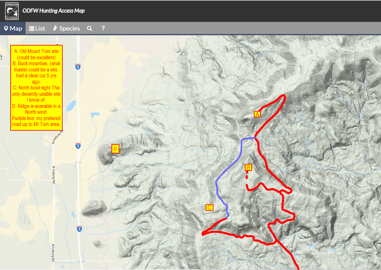
- If wind is expected to be strong NW, drive to the road that cuts across the slope halfway up, no gate. Take Shotgun Creek Road and Crooked Creek Road to the top of the ridge, u-turn back down one road and head SW, no more turns necessary. This road is plenty high to clear some tall trees and glide to the sloping pastures below.
- If you want to launch from the top (3450 ft), park at the locked gate on the saddle (turn SW 2 roads prior to the ridge). This saddle is very wide open and not steep, so you should be able to land near your car. The hike up from the locked gate is under a mile.
Sent: Saturday, July 20, 2019 11:22 PM
To: dirkl...@gmail.com <dirkl...@gmail.com>
Cc: Bill Briskey <bill.b...@gmail.com>; David Le <asians...@gmail.com>; Cascade Paragliding Club <cp...@googlegroups.com>
Subject: Re: CPC: Coburg Ridge this weekend.

Nick Fulmor
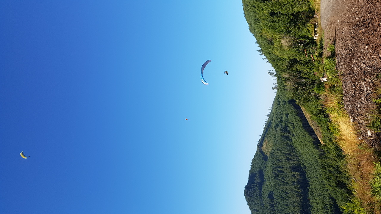
Bill was the first of us in the air when we went back to Briskey Bowl. It was strong but he handled like a pro. I followed shortly after and then Kevin. We all were a bit plucked. Definitely a s and d s kinda place. The ridge had abundant lift and there was a strong house thermal directly above launch. Easy glide out to the ridge towards I5 and a huge field to land in.
Tried the bailout lz today and it was smooth and easy to hit.

Luke
From: Nick Fulmor
Sent: Sunday, July 21, 2019 9:20 PM
To: Cascade Paragliding Club
Subject: Re: CPC: Coburg Ridge this weekend.
We arrived at the mohawk general at 9am on Saturday. We headed up the hill around 915. When we arrived on launch it looked like it had great potential. All of the things you could ask for from a site. Big launch, easy bailout, lots of xc options, great road the whole way up. This place is gold we were already convinced. We continued down the road to check out some possibilities. One place looked promising but we would need permission from weyerhouser.
Bill was the first of us in the air when we went back to Briskey Bowl. It was strong but he handled like a pro. I followed shortly after and then Kevin. We all were a bit plucked. Definitely a s and d s kinda place. The ridge had abundant lift and there was a strong house thermal directly above launch. Easy glide out to the ridge towards I5 and a huge field to land in.
Tried the bailout lz today and it was smooth and easy to hit.
--
You received this message because you are subscribed to the Google Groups "Cascade Paragliding Club" group.
To unsubscribe from this group and stop receiving emails from it, send an email to cpcl+uns...@googlegroups.com.
To view this discussion on the web visit https://groups.google.com/d/msgid/cpcl/681a56f5-472a-4f52-8015-bef03de9abc1%40googlegroups.com.

Kaviyaan Khalil
To view this discussion on the web visit https://groups.google.com/d/msgid/cpcl/5d35b5a4.1c69fb81.6e474.01c5SMTPIN_ADDED_MISSING%40gmr-mx.google.com.
David Le
Jens Peterson
--
You received this message because you are subscribed to the Google Groups "Cascade Paragliding Club" group.
To unsubscribe from this group and stop receiving emails from it, send an email to cpcl+uns...@googlegroups.com.
To view this discussion on the web visit https://groups.google.com/d/msgid/cpcl/681a56f5-472a-4f52-8015-bef03de9abc1%40googlegroups.com.
Mike Steed
Mike Steed
Jens Peterson

Jove Lachman-Curl
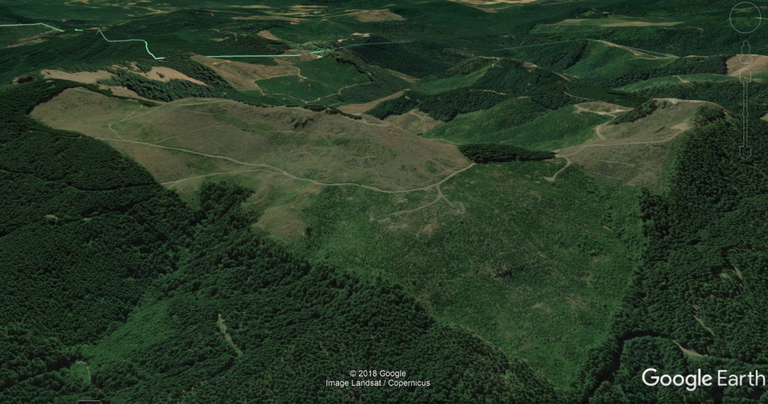
The other interesting piece of history I have; "back in the day" when HP was big in corvallis hiring a lot of engineering wages there were a lot of hang pilots using the coburgs. "Mount Tom" was the premier site up there, this is the tallest peak, and when you look at the two hills in the coburgs from I5, it's the one to the left. This hill has a north west facing face that is pretty ideal for summer winds. It is at over 3000 Ft above the valley floor. Legend has it that they had a big wooden radial launch ramp on the north west face where I've located the A. in the image below. It is on Weyerhaeuser land, A HG pilot died here due to an equipment assembly mistake and there was some kind of disagreement with Weyerhaeuser and the ramp was cleared and they planted trees on the site. I've walked it, it's potentially an awesome site. But covered in 20" diameter 2nd growth trees last time I looked.
44°16'18.2"N 122°56'20.8"W
cheers,Jove
To view this discussion on the web visit https://groups.google.com/d/msgid/cpcl/626466A3-C902-4ADB-B68C-DCA24CDB88B6%40gmail.com.
Mike Steed
Bill Briskey
To view this discussion on the web visit https://groups.google.com/d/msgid/cpcl/MWHPR13MB161456D02E23EFD1AE07AC96BAC10%40MWHPR13MB1614.namprd13.prod.outlook.com.
Jove Lachman-Curl
Jens Peterson
Hi all,
<image.png>
--Bill

John S
John Saltveit
On Thursday, July 18, 2019 at 1:51:57 PM UTC-7, David Le wrote:
Jens Peterson
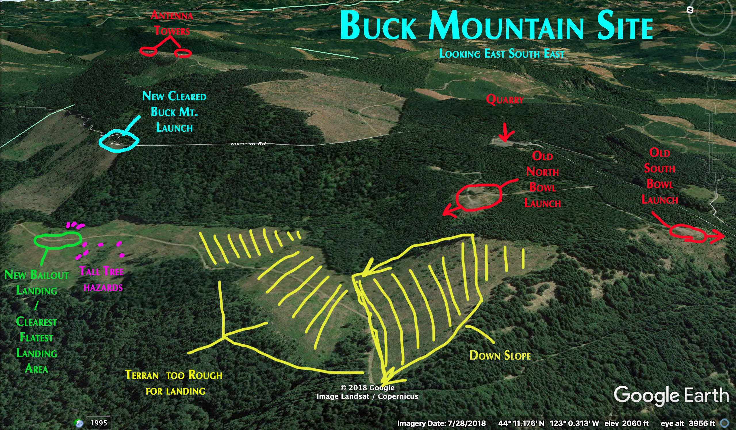
On Jul 26, 2019, at 7:42 AM, Mike Steed <steed...@hotmail.com> wrote:Nice job on the image, belongs on a site guide….
On Jul 25, 2019, at 10:52 PM, Jens Peterson <jens.p...@gmail.com> wrote:
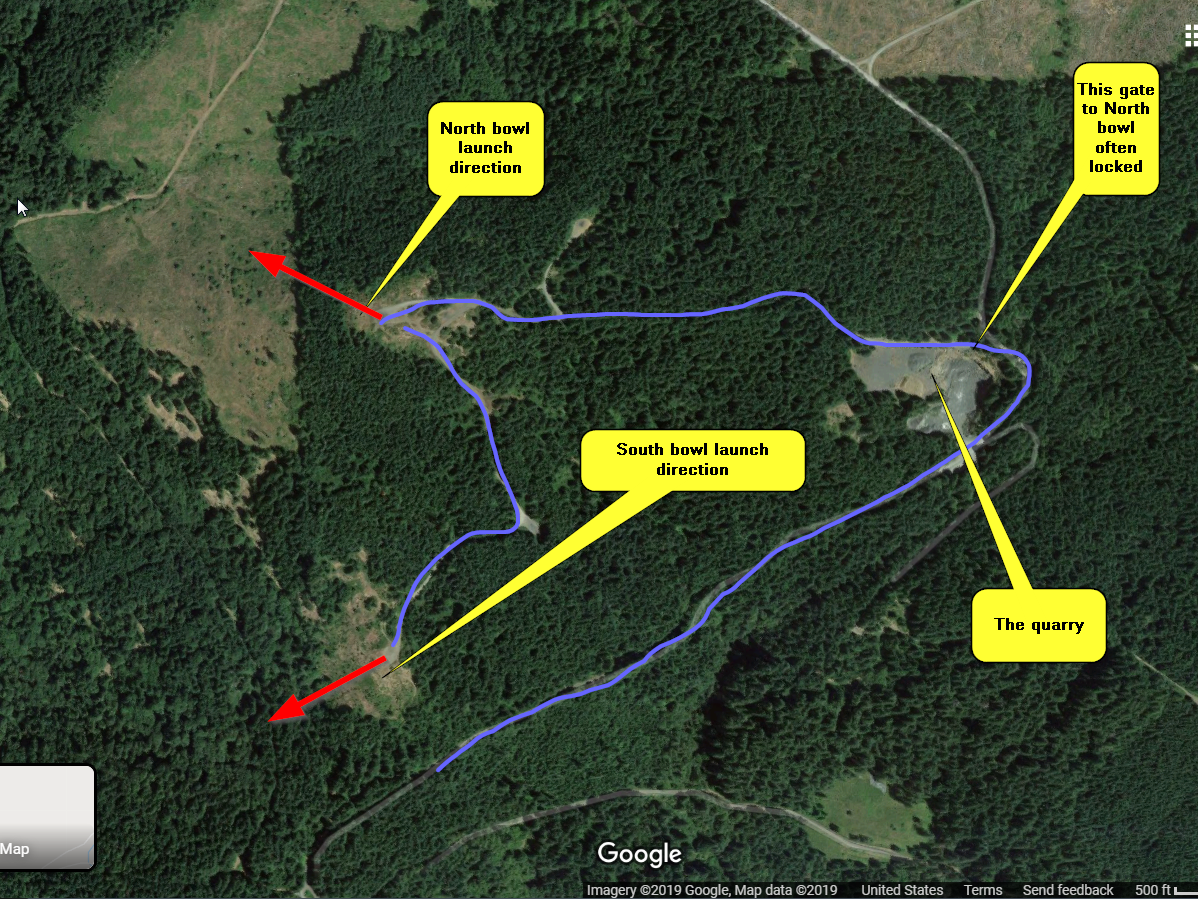
Jove, and everyone else.Thanks for the info, Yes I hiked some of the areas you were taking about, Such as "North Bowl” It still looks very usable as a launch, Not sure about enough glide to make it to the good leaning area if you hit some sink on the way to bailout, but good top landing for PG’s right behind launch I did notice a few Crosses with names on them at the edge of what looks like a take off.The Clearred section just below it, is the south end of the same clearing as the Bailout LZ for the Buck Mountain Fights we did last weekend, we were just landing in the further north section that was less variable Terran, its not as flat down in the clearing as it looks from above. and highly advise anyone thinking of flying the Buck Mountain Site, to walk the Lower Bail out Clearing area for themselves before flying.You will want to make your final in line with the road, and further to the north, just past the last of the standing dead trees in the middle of the clearing. this is the widest section to burn off altitude before turning for final down the road. and the clearest section next to the road that is not riddled with blackberry bushes, scattered everywhere including right next to the road. the road is also the flattest, anything else has more mounds and valley than you can see well from above.Hope this image is useful to others.
<Buck Mountain Site ESE.jpg>