Avare release 7.2.3 beta

Zubair Khan
http://www.apps4av.org/share/beta/Avare.apk.7.2.3beta.zip
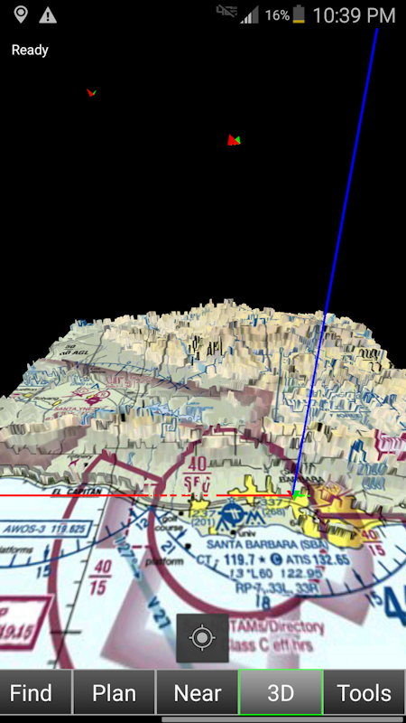
Note: This screen requires significant memory and processing power, and may crash / misbehave on older devices.
To see charts in 3D, download elevation charts from the Download menu for your area. Charts and other data will be displayed under 3D tab.
Move around on the 3D screen using touch. To check out 3D view of a destination you have not been to, use Simulation mode with Destination set to the destination.
<ul>
<li>If the center button is gray, you are in Satellite Camera mode.</li>
<li>You will see your aircraft with left wing colored red, and right wing colored green.</li>
<li>Several straight lines emerge from your ship to show your heading. Magenta line shows your current track, and disappears under terrain higher than your altitude.</li>
<li>If you are receiving ADSB traffic, you will see other aircrafts with red/green wing colors that follow the nav lights convention.</li>
<li>Pinch with two fingers to zoom in and out. Pan left, right, up, and down with finger swipe. Rotate the map with two finger rotate.</li>
</ul>
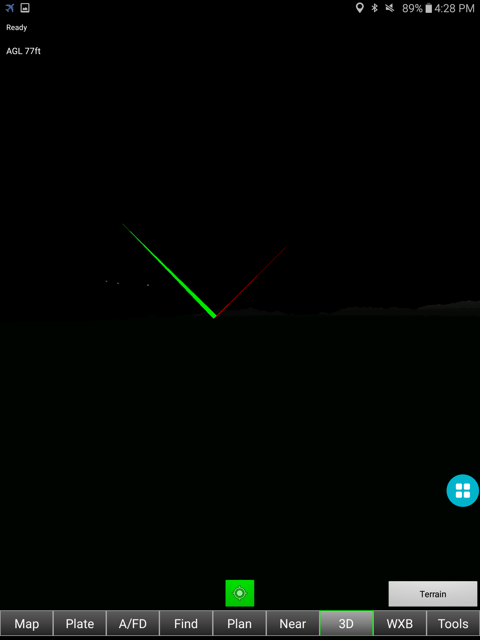
<ul>
<li>If the center button is green, you are in Pilot Camera mode. You can get in/out of this mode by long pressing the center button.</li>
<li>You will see as if you are looking out from the front wind screen of your aircraft. You will not see your own aircraft.</li>
<li>If you are receiving ADSB traffic, you will see other aircrafts with red and white wing colors that follow the Nav lights convention.</li>
<li>Pinch with two fingers to zoom in and out. Look left, right, up, and down with finger swipe.</li>
<li>Compare the device screen with your front wind screen to find the location of traffic in real world.</li>
</ul>
</p>

John W SBA
version numbers might be helpful with such rapid improvements). It's
working great on a Samsung S4 J12.SAM.SCH-1545-0 Android 5.0.1 using the
HIZ Pro app running an SDR.
It's very cool to see ADSB traffic in 3D! With a few ground tests
tonight I didn't get to see how it portrays any of the few GA ADSB Out
a/c we see around here in flight, so it was only the airliners passing
high above as seen in these screen caps comparing Map & 3D view.
For anyone else who's a bit forgetful of Avare features and options not
often used and who thus missed a few key points I'll outline them:
*As mentioned by Zubair, before 3D will work you need to
Download/Terrain/[your file, in my case Elevation SW]. I point this out
because in testing an earlier version of this new 3D feature I forgot
having done an Uninstall/Reinstall of Avare that wiped the file off my
Samsung S4 phone, after which I only downloaded my Databases and
Sectional files. (Zubair, this is maybe why I was getting the weird
tiles when others weren't)
*I also downloaded Shaded Relief Download/Terrain/Shaded Relief SW and
like it better than Sectional for 3D because it lacks the clutter and
unreadable text, and adds color to further clarify terrain elevation.
Due to being active 3D, you don't really need it to get a quick sense of
terrain but I'll probably use Shaded Relief in 3D mode. At some point
maybe there will be a Map/3D toggle button and a preset preference so
that flying with just one device would quickly toggle everything with a
single button. A chart type selector on the 3D screen could also be
helpful, by eliminating the need to tap Map, Options, chart type,
Sectional/Shaded Relief, (scroll bottom tab on a small screen like the
S4), and 3D.
Zubair wrote:
> toggle between these modes using the TrackUp/NorthUp button
it was Off because I've never used Track Up in flight.
> in the bottom-center of the 3D screen.
Center button. I was first looking for a Track Up button, then
remembered it's a secondary function of the oft-used gray Center button
that I tap to center the map on my current location, then remembered
that Track Up takes a Long Press on that Center button (did I mention
being a bit forgetful? :)
> may crash / misbehave on older devices.
exploring for a total of a 5-20 minutes each. Pinch, pan, and rotate
all work *much* better than in the first beta. I especially like being
able to zoom in past the horizontal screen margins now. I might set one
of my S4 phones up to run this as backup to the Nexus 7 I use for
primary x/c nav charts (sticklers please don't panic, I have a GNS430
and Lowrance 1000 that being less useful with more complex interface
serve as backups to Avare along with copies of Avare on the two S4s on
most every x/c flight).
*Quirk: In two of 5 tests both of the 3D modes were showing "No GPS
Signal" in red at top-right despite 3D apparently working, and Tools
view showing my coordinates with 10' altitude accuracy and 15 satellites
in green. No such warning in Map view, and location on the chart is
shown correctly. I'm using GPS-only in the Android screen:
Settings/More/Location/Mode/GPS only if that makes a difference. This
is the setting I use in flight to prevent Google from trying to phone
home despite my use of Airplane Mode when cell towers are scarce. For
some reason I've not discovered, two of five times (first and last) I've
launched Avare and tried 3D mode in this session the red warning was absent.
*Quirk: Center button (tap) doesn't correlate with either Find choice
(SBA in my case) or current GPS location, but rather some arbitrary
location slightly off-center from both of the above (maybe it centers in
the current chart tile?). This is like the behavior I saw on an earlier
version in flight, when the map displayed didn't change until I flew
near the edge. My guess is this behavior won't be changed unless/until
Avare is reconfigured for higher end/newer devices and Android versions.
*Quirk: In "Pilot" view, scrolling is weird on the ground. Since I'm
stationary, at startup (or by tapping the Center button) I'm looking
North up into the bottom of the terrain as if swimming in the ocean and
looking up at a wave. That makes sense, but is strange at first. But
when I rotate the screen toward the South sometimes the terrain scrolls
off the top (and sometimes bottom) of the screen leaving only black. If
I tap the Center button it comes back, but apparently rotating the
screen with a diagonal swipe follows the terrain until it touches the
screen edge, then tends to move the terrain out of view rather than
mostly follow it. This seems to be because the vertical component of a
swipe actually tilts the horizon rather than just moving it up/down on
the screen. Presumably this is why it's called Pilot (point of) view,
because the vertical component is changing as if I were looking up/down.
My guess is this will not be an issue in flight unless flying below
terrain like in a canyon.
*Observation: I tried Landscape mode to see if if provides better
functionality in 3D mode, and at present it apparently doesn't. Still
works great, and I typically run Avare in Portrait mode anyway.
*Observation: Battery use seems substantially greater in this mode.
I've not tested this, but my impression is that the S4 struggles a bit
having the SDR plugged in while running Avare, HIZ and GPS. Frankly I'm
amazed the S4 can do it at all, given how much computing power is
probably involved even with the exceptionally lean and fast coding
behind all this. To use this setup for more than the occasional brief
glance or in high-traffic area transitions, I'll need either a way to
add external power (impossible for me at present while the SDR is
plugged in) or build a Stratux and use Blutooth for the ADSB data with
the Avare device plugged into ship's power. In the past I've used ADSB
briefly like that and then plugged back into ship's power, also keeping
screen brightness set at the lowest comfortable level for current
conditions and have easily done 4-6 hour x/c flights.
Bottom line: If you love Avare and have an ADSB In receiver, you want to
play with this! Kudos, congratulations and thanks to Zubair, Mike, and
everyone who helped on the Avare team! :D

Domenic
Thanks!
Zubair Khan
Hi Domenic.
I was with a student today at OWD 7 am. A heli flew over us. Probably you?
I tested pilot cam there and seemed OK.
I will check with Heli charts. Did you test it with ADSB?
Thanks for testing.
Looks and works great. I have noticed that it does not render helicopter charts at all. Does it only do Sectional and TAC (both of which work on my phone and tablet).
Thanks!
--
You received this message because you are subscribed to the Google Groups "Apps4Av Forum" group.
To unsubscribe from this group and stop receiving emails from it, send an email to apps4av-foru...@googlegroups.com.
To post to this group, send email to apps4a...@googlegroups.com.
Visit this group at https://groups.google.com/group/apps4av-forum.
For more options, visit https://groups.google.com/d/optout.

command...@gmail.com
1) rendering wasn't that great with the NVidea Shield tablet. Screen was mostly black (seemed to remain on edge of map tile), and the hills were rough and columnar.
2) Mode was easy to select, which was good.
3) Sectional isn't the best in this mode, but didn't want to spend the time flipping maps when changing between 2d and 3d; too much time in the cockpit.
4) Didn't catch any ADSB traffic during my brief test.
I'll take a look again on my return flight.
Jeff
command...@gmail.com
1) I calculated that the 3d view centers the map 25nm South of my actual position, and this is likely why I mostly see only the black of the edge of the map. Zooming didn't seem to affect the behavior. The measurement was possible in the satellite view, where I saw my plane 25nm north and at the edge of the tile.
2) I was able to pick up ADSB traffic on the flight home. The plane icons took a little adjusting to before I could make out what I was looking at. The image didn't really help me locate the traffic. Even with traffic that was west of me, and thus over the map tile, I couldn't really get a sense of where it was in space. I had a much easier time finding the traffic when given the position and altitude info on the map screen.
I do not yet have ADSB out. I was picking up traffic from Mike's app in UAT mode. I was happy to see traffic. Too bad my primary tablet (Samsung galaxy tab S2) doesn't allow charging with the dongle.
Zubair Khan
You will need to update Terrain->Elevation charts from Download area of Avare. If you do not update charts, you will see same low resolution charts and it may not even give you correct height.
You will also see obstacles in your area. In pilot cam, anything at or above center of screen is at collision course.
Retesting requested. Updated app at http://www.apps4av.org/share/beta/Avare.apk.7.2.3beta.zip
Thanks
On Monday, May 23, 2016 at 1:46:43 AM UTC-4,
command...@gmail.com
1) The terrain looks better than it did. It is still a little rough to be able to use it to get oriented.
2) I like the separate map selection button and appreciate that it leaves the map page untouched.
3) I like that the orientation button on/off state is separate from the track-up/north-up state of the map screen. I wish the plan page was the same way, independent from the map screen.
4) I notice that I cannot see traffic that is not in front of me. I have to pan to see it.
5) Panning initially works okay, but if I try to pan up or down, then it becomes unstable regarding which direction to pan.
A separate issue, and I don't know if it is due to the latest version or the marshmallow update my tablet received, but tracking is no longer working... which I consider a major issue. The flight tracks are a major reason why I use Avare. I can't tell if it is a permission issue, and I don't know where Avare is trying to write the tracking file. Unfortunately, this doesn't seem to be controlled by a preference.
Jeff
Zubair Khan
1) The terrain looks better than it did. It is still a little rough to be able to use it to get oriented.
2) I like the separate map selection button and appreciate that it leaves the map page untouched.
3) I like that the orientation button on/off state is separate from the track-up/north-up state of the map screen. I wish the plan page was the same way, independent from the map screen.
4) I notice that I cannot see traffic that is not in front of me. I have to pan to see it.
5) Panning initially works okay, but if I try to pan up or down, then it becomes unstable regarding which direction to pan.
A separate issue, and I don't know if it is due to the latest version or the marshmallow update my tablet received, but tracking is no longer working... which I consider a major issue. The flight tracks are a major reason why I use Avare. I can't tell if it is a permission issue, and I don't know where Avare is trying to write the tracking file. Unfortunately, this doesn't seem to be controlled by a preference.
Jeff
--
You received this message because you are subscribed to the Google Groups "Apps4Av Forum" group.
To unsubscribe from this group and stop receiving emails from it, send an email to apps4av-foru...@googlegroups.com.
To post to this group, send email to apps4a...@googlegroups.com.
Visit this group at https://groups.google.com/group/apps4av-forum.
For more options, visit https://groups.google.com/d/optout.

bman
Zubair Khan
Yes, all 3D processing stops when not in 3D. All memory used is also released.
Does this new version use huge processing when NOT in 3D mode? In other words, if downloaded to older machine and not put in 3D mode, will software operate just as before?
command...@gmail.com
Was there an important reason to get rid of the AGL data field from the map screen? Was it not possible to have it as a data field in addition to the 3D screen?
To answer your question about my comment regarding rough terrain, I suppose I meant both. I don't doubt that the source files are accurate, but the way they must be scaled for the display makes them very jagged and un-natural. I live near a very recognizable mountain. I don't recognize it in pilot view. Even the demo pictures of the mountains near SBA are very pointy. Just my feedback. Not sure anything could be done.
I did mean the track-up/north-up button on the plate view. Thanks for putting that in the plans for the next release.
Zubair Khan
AGL and obstacles are moved to 3D. This frees up a bunch of memory and makes Map screen faster.
Thanks
command...@gmail.com
1) per your request in another thread, I will send you pictures of Mt. Diablo south east of Concord, CA (KCCR). I'd attach them to this thread, but I don't see an option to do that here on my tablet. I think Google Earth would do a better job than I can.
2) The track up Vs north up button on the plate page is now broken. Although you can set it independently, the button no longer does anything. Plate orientation uses the setting from the map page.
Jeff Iskin
This picture is of the mountain, and if you can zoom in on the tablet, you will see the 3D display.
--
You received this message because you are subscribed to a topic in the Google Groups "Apps4Av Forum" group.
To unsubscribe from this topic, visit https://groups.google.com/d/topic/apps4av-forum/lwo2WJFbuLo/unsubscribe.
To unsubscribe from this group and all its topics, send an email to apps4av-foru...@googlegroups.com.
command...@gmail.com
Zubair Khan
--
You received this message because you are subscribed to the Google Groups "Apps4Av Forum" group.
To unsubscribe from this group and stop receiving emails from it, send an email to apps4av-foru...@googlegroups.com.
To post to this group, send email to apps4a...@googlegroups.com.
Visit this group at https://groups.google.com/group/apps4av-forum.
For more options, visit https://groups.google.com/d/optout.
command...@gmail.com

fly...@yahoo.com
Try Ver.730, it solves many issues. Let us know if you are still having the problem. TV
| >>commander |
command...@gmail.com
1) In pilot view:
a) When zooming in, view scrolls left. When zooming out, view scrolls right.
b) When zooming in, scrolling in either direction takes longer to move x number of degrees.
c) Only the shaded relief map shows proper proportions of terrain. All other maps show a flatter and unrecognizable terrain.
d) Map tile does not load a tile until on it. If flying along the edge or otherwise near the edge of the tile, the view is mostly black nothingness.
e) Without some sort of visual center guide, it is not easy to spot which terrain is above current altitude. The center of the screen is not a good enough guide by itself.
2) Satellite view:
a) Same observation as 1) d) above.
b) Magenta heading line is constantly appearing and disappearing, regardless if pointing at higher terrain. Line completely disappears.
c) My original observation about being approximately 25nm north of center is still valid depending upon which map is chosen. Shaded relief is the only map that shows correct centering.
3) Other observations:
a) Timers, like fuel timer, are not controllable when in plate view. Only when in map view.
No new observations with ADS-B.
Zubair Khan
> a) When zooming in, view scrolls left. When zooming out, view scrolls right.
This to be fixed.
> b) When zooming in, scrolling in either direction takes longer to move x number of degrees.
This too is connected to the above and is in scaling. Will be fixed. Minor at this point right?
> c) Only the shaded relief map shows proper proportions of terrain. All other maps show a flatter and unrecognizable terrain.
I have tested in many locations and its same. Could you send difference in pics? It is surprising that you have this because the terrain that lifts the chart is same for all charts.
> d) Map tile does not load a tile until on it. If flying along the edge or otherwise near the edge of the tile, the view is mostly black nothingness.
This is the biggest and most annoying issue. We are working on this and will take time. Maybe a month.
> e) Without some sort of visual center guide, it is not easy to spot which terrain is above current altitude. The center of the screen is not a good enough guide by itself.
>
Agree 100% and this was the next thing to be added in next release.
> 2) Satellite view:
> a) Same observation as 1) d) above.
> b) Magenta heading line is constantly appearing and disappearing, regardless if pointing at higher terrain. Line completely disappears.
This seems to he issue with release 7.3.0. Could you check what the Help says about which version you have? Or maybe this is not fixed. But please confirm.
> c) My original observation about being approximately 25nm north of center is still valid depending upon which map is chosen. Shaded relief is the only map that shows correct centering.
>
I think you need to reinstall Avare. You have probably some old and some new charts and thats causing it. Plus assuming you do not have 7.3.0. If you have everything current then we need to investigate your device version.
> 3) Other observations:
> a) Timers, like fuel timer, are not controllable when in plate view. Only when in map view.
Awesome. Never knew this. Fix in next release.
Thanks for the tests J.
Z
>
> No new observations with ADS-B.
>
Jeff Iskin
I got some screen captures when down at the airport.
I am seeing the same behavior on three devices:
Samsung Galaxy Tab S2 Android 5.1.1
NVIDIA Sheild tablet Android 6.0.1
Samsung Galaxy S5 Android 5.0
On Jun 5, 2016 6:48 AM, "Zubair Khan" <gove...@gmail.com> wrote:
>
>
> > a) When zooming in, view scrolls left. When zooming out, view scrolls right.
>
> This to be fixed.
Good.
>
> > b) When zooming in, scrolling in either direction takes longer to move x number of degrees.
>
> This too is connected to the above and is in scaling. Will be fixed. Minor at this point right?
When zoomed in pretty far, it takes a lot of effort and head-down time to scroll around. It is minor to me, as I don't think this view will be helpful for me.
>
> > c) Only the shaded relief map shows proper proportions of terrain. All other maps show a flatter and unrecognizable terrain.
>
> I have tested in many locations and its same. Could you send difference in pics? It is surprising that you have this because the terrain that lifts the chart is same for all charts.
Pics attached.
>
> > d) Map tile does not load a tile until on it. If flying along the edge or otherwise near the edge of the tile, the view is mostly black nothingness.
>
> This is the biggest and most annoying issue. We are working on this and will take time. Maybe a month.
Yep.
>
> > e) Without some sort of visual center guide, it is not easy to spot which terrain is above current altitude. The center of the screen is not a good enough guide by itself.
> >
>
> Agree 100% and this was the next thing to be added in next release.
Cool.
>
> > 2) Satellite view:
> > a) Same observation as 1) d) above.
> > b) Magenta heading line is constantly appearing and disappearing, regardless if pointing at higher terrain. Line completely disappears.
>
> This seems to he issue with release 7.3.0. Could you check what the Help says about which version you have? Or maybe this is not fixed. But please confirm.
Help text on tablets show version 7.3.0. My phone still has 7.2.7 (but not for long :) ).
>
> > c) My original observation about being approximately 25nm north of center is still valid depending upon which map is chosen. Shaded relief is the only map that shows correct centering.
> >
>
> I think you need to reinstall Avare. You have probably some old and some new charts and thats causing it. Plus assuming you do not have 7.3.0. If you have everything current then we need to investigate your device version.
Doesn't appear to be device specific. The attached pics are from the same device ( Samsung tab), but look the same on the others. Notice my location in comparison to the edge of the tile between shaded relief and the others.
>
> > 3) Other observations:
> > a) Timers, like fuel timer, are not controllable when in plate view. Only when in map view.
>
> Awesome. Never knew this. Fix in next release.
Me either until I tried to use it :)
Thanks for everyone's efforts with this software. It really is fantastic.
Jeff
Zubair Khan
Thanks jeff
It helped a lot.
Actually shaded relief is a low resoution chart and hence covers larger area than sectional. That mountain is not visible on sectional because its off of tile. See satelliye view. It will show when you get closer to it, and when it shows on sectional, it will look the same shape as on shaded relief.
If you try WAC, you will see that mountain because WACs cover larger area.
Due to memory restrictions we cannot show beyond a certain distance. So the mountain is there, its just not visible because it is far.
Z
command...@gmail.com
That explains that.
Latest version seems to be much better with scrolling and zooming now. It appears that vertical panning is allowed again. This is good, but I wish the brown horizon indicator stayed on the horizon instead of following the pan.
I didn't hook up the dongle for ADSB, so I'll have a look at that on the next flight.
So I did find the 3D view useful tonight. Sometimes the sectional on the map screen is too bright for night flight. The pilot view of 3D is a nice screen to switch over to for a darker image. Sometimes I wish Avare had an HSI screen, just showing the top portion of the heading arc and marker for desired track.
I'm not sold on the sweeping magenta line in satelite view, but the concept is valuable. Instead of sweeping in a circular pattern, how about just pointing ahead so the pilot could rotate the map to point at terrain he/she is interested in? To do so, you may have to get rid of the blue line. The yellow line should remain as is, showing where the nose is pointed.
Thanks again for separating tbe north-up/track-up setting on the plate page. This is a really nice improvement.
Jeff
Zubair Khan
Jeff
--
You received this message because you are subscribed to the Google Groups "Apps4Av Forum" group.
To unsubscribe from this group and stop receiving emails from it, send an email to apps4av-foru...@googlegroups.com.
To post to this group, send email to apps4a...@googlegroups.com.
Visit this group at https://groups.google.com/group/apps4av-forum.
For more options, visit https://groups.google.com/d/optout.
command...@gmail.com

Zubair Khan
Sent from ProtonMail mobile
-------- Original Message --------
On Oct 18, 2016, 1:42 AM, wrote:
Wanted to follow up that it is still not possible to start/stop timers from the plate page. IIRC, it started working and then stopped again in a newer release. I needed quick access to a timer during an ILS, and this would have been helpful.
--
You received this message because you are subscribed to the Google Groups "Apps4Av Forum" group.
To unsubscribe from this group and stop receiving emails from it, send an email to apps4av-foru...@googlegroups.com.
To post to this group, send email to apps4a...@googlegroups.com.
Visit this group at https://groups.google.com/group/apps4av-forum.
To view this discussion on the web visit https://groups.google.com/d/msgid/apps4av-forum/db680fab-438c-4e63-a3a3-d6658635e5ab%40googlegroups.com.