I often think that life is the London basic rail network ...
301 views
Skip to first unread message

TiddlyTweeter
Feb 4, 2020, 3:57:28 PM2/4/20
to TiddlyWiki
The amazing topology of depiction of the internal London rail network is a high water mark of logical graphical representation.
Could one, in TW, in some way, layout how to get from Chesham to Parsons Green?
Just wondering
TT

TiddlyTweeter
Feb 4, 2020, 3:58:54 PM2/4/20
to TiddlyWiki
2nd copy for those on email.

Mat
Feb 4, 2020, 4:09:31 PM2/4/20
to TiddlyWiki
If drawing on top of it is sufficient then maybe http://overlay.tiddlyspot.com/
(or for proper transparency: https://github.com/Jermolene/TiddlyWiki5/issues/4035 )
<:-)
TiddlyTweeter
Feb 4, 2020, 4:21:55 PM2/4/20
to TiddlyWiki
Ha! Nice one. So where is the overlay of the map? :-)
Mat
Feb 4, 2020, 4:27:04 PM2/4/20
to TiddlyWiki
TiddlyTweeter wrote:
Ha! Nice one. So where is the overlay of the map? :-)
If you mean it as "can I get it"? Then, yes, it is only a few minutes away after you've installed the tiddlers there.
If you mean "where/how is the overlay stored?" then the answer is that it is stored as a regular image tiddler titled <originalimagetitle>-overlay
<:-)

Mohammad
Feb 5, 2020, 4:58:13 AM2/5/20
to tiddl...@googlegroups.com
Lovely!
I just wondering why not shared these to Forum!
--Mohammad
Mat
Feb 5, 2020, 5:27:05 AM2/5/20
to TiddlyWiki
Mohammad wrote:
I just wondering why not shared these to Forum!
Assuming you're referring to my thing above: I have not announced it officially because it is too prototypical and rough. If that github request for actual canvas transparency was solved then I'd give it more work. I do think it would be really useful to be able to draw and scribble in TW, e.g to underline text and make margin notes, so if you agree then give the github request a thumbs up and perhaps mention what you'd use it for.
<:-)
Mohammad
Feb 5, 2020, 5:54:32 AM2/5/20
to TiddlyWiki
Still it is very useful. I will vote for it on GitHub!
--Mohammad
<:-)

HC Haase
Feb 5, 2020, 6:18:30 AM2/5/20
to tiddl...@googlegroups.com
tirsdag den 4. februar 2020 kl. 21.57.28 UTC+1 skrev TiddlyTweeter:
The amazing topology of depiction of the internal London rail network is a high water mark of logical graphical representation.
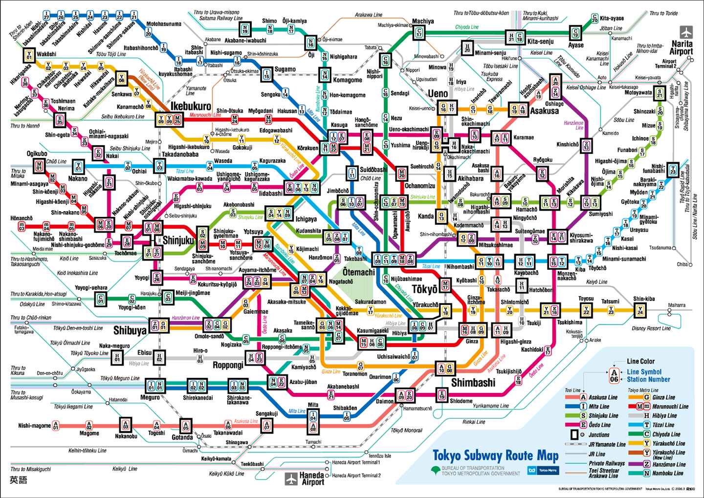
I like the Tokyo subway more.
Could one, in TW, in some way, layout how to get from Chesham to Parsons Green?
As a geographer, the problem of route planning has crossed my path. The classical way of finding an optimal route is to make a network of nodes and edges, assign a penalty value to the nodes and calculate the cumulative penalties for all possible connections form a to b. then you can find the lowest one. That could be done with tiddlers, but I feel TW would not be the best tool.
Why do you want this in TW? Just to try it out?
Just wondering
You do that a lot.
But tell me more about "I often think that life is the London basic rail network ... "
| | |
| | |
| | |

ILYA
Feb 5, 2020, 9:47:49 PM2/5/20
to tiddl...@googlegroups.com
This is a great idea!
I was looking for a plugin which would allow me to annotate pdfs. I wanted to see a part of a page and highlighted quote I am extracting.
One of the problems with pdfs is how to navigate it to open at the right place. I know it is possible to open specific page. But controlling zoom or highlighting the region is not available.
Thank you for sharing an overlay approach.
Best regards,
ILYA
--
Sent from my Android device with K-9 Mail. Please excuse my brevity.
Sent from my Android device with K-9 Mail. Please excuse my brevity.

A Gloom
Feb 6, 2020, 6:17:52 AM2/6/20
to TiddlyWiki
This doen't allow "drawing" over an image but it can display (with turning layers on a off) an overlay or many overlays once created
__NOTES__:<br/>1) //with svg's-- external images, raster & vector, not part of the svg code but inserted with a image element inside the svg will not display when the svg is used with html img tag//<br/>
2) //mouse / pointer events like hover don't work with html img tags for external svg display//
2) //mouse / pointer events like hover don't work with html img tags for external svg display//
<$reveal type="nomatch" state="!!filter-field" text="show">
<$button set="!!filter-field" setTo="show">hide terrain</$button>
<style>.maptestop {opacity:1;}</style>
</$reveal>
<$reveal type="match" state="!!filter-field" text="show">
<$button set="!!filter-field" setTo="hide">show terrain</$button>
<style>.maptestop {opacity:0;}</style>
</$reveal>
<!-- button 2 -->
<$reveal type="nomatch" state="!!filter-field1" text="show">
<$button set="!!filter-field1" setTo="show">hide overlay</$button>
<style>.maptestop2 {opacity:1;}</style>
</$reveal>
<$reveal type="match" state="!!filter-field1" text="show">
<$button set="!!filter-field1" setTo="hide">show overlay</$button>
<style>.maptestop2 {opacity:0;}</style>
</$reveal>

<div style="position:relative; width:100%; margin:0px; padding:0px; vertical-align:top; border:dotted 4px;">
@@.maptestop
<img src="mapcityL301.png" width="" height="" class="maptestop"/>
@@
<div style="position: absolute; left:0; top:0; width:100%; margin:0px; padding:0px; vertical-align:top; border:dotted 4px;">
@@.maptestop2
<img src="mapareaL3new.svg" width="" height="" class="maptestop2"/>
@@
</div>
</div>
TiddlyTweeter
Feb 6, 2020, 8:02:24 AM2/6/20
to TiddlyWiki
HC Haase wrote:
I like the Tokyo subway more.
Very nice! TX.
Could one, in TW, in some way, layout how to get from Chesham to Parsons Green?As a geographer, the problem of route planning has crossed my path. The classical way of finding an optimal route is to make a network of nodes and edges, assign a penalty value to the nodes and calculate the cumulative penalties for all possible connections form a to b. then you can find the lowest one. That could be done with tiddlers, but I feel TW would not be the best tool.
Perhaps not. Part of the issue, I think, is methods of diagramming we integrated so far through JS.
Why do you want this in TW? Just to try it out?
Yes, in that I like topology graphics for presenting info.
But my interest is ultimately in creating and navigating charts of the history of genre in cinema. Difficult to explain but topological maps will do it.
But tell me more about "I often think that life is the London basic rail network ... "
It was a superb breakthrough in graphical representation for common use.
Another brilliant one is Napoleons' campaign ...

Best wishes
TT
TiddlyTweeter
Feb 6, 2020, 8:06:15 AM2/6/20
to TiddlyWiki
Ciao Mat
It is very suggestive of an approach that might work!
Tx,
TT
TiddlyTweeter
Feb 6, 2020, 8:11:16 AM2/6/20
to TiddlyWiki
Ciao Gloom
Interesting riff off Mat's demo! I will take a closer look!
Best wishes
TT
Mat
Feb 6, 2020, 12:47:22 PM2/6/20
to TiddlyWiki
TiddlyTweeter wrote:
Ciao MatI played more with your demo of overlay drawing.It is very suggestive of an approach that might work!
Good to hear.
<:-)
A Gloom
Feb 7, 2020, 1:13:46 AM2/7/20
to TiddlyWiki
The SVG Editor ( https://tid.li/tw5/apps/svg.html ) demo'ed previously would also work as an overlay editor.
* first element in the svg would be your raster image using the
<image href="mapareaL3new.png" x="0" y="0" height="100%" width="100%" />
(older depreciated <image xlink:href="mapareaL3new.pmg" x="0" y="0" height="100%" width="100%" />)
OPTIONAL: x="0" y="0"
positons the raster image inside the svg, x="0" y="0" is upper left corner of svg
REQUIRED: height="100%" width="100%"
scales raster image to fit the full space of the svg, you can reduce the amount of space inside the svg the raster image occupies -- to change the svg overlay & raster image together, use the height="" width="" sttributes in root svg tag <svg ...>
the raster image will be scaled automatically by the svg
-- this can also be done with the foreignObject tag for pdf, html, text pages-- in the "Quad Stuffed SVG's" topic iirc I show a 4 pane svg viewer/navigator with in-tiddler svg map key (left side) & map and 2 foreignObject iframes for displaying external html page and raster images (right side)
* then after that (below the in the code so they sit over the raster image-- svg works like html in stacking order-- first element at bottom, last element on top)
-- using svg overlay allows embedding wikitext and tiddler links

TonyM
Feb 7, 2020, 4:03:33 AM2/7/20
to TiddlyWiki
Ilya,
do checkout the free version of foxit pdf reader. Lots of off annotation and more.
Tony

Drevarr the Old
Feb 9, 2020, 5:39:58 PM2/9/20
to TiddlyWiki
This post made me attempt to create a TiddlyMap of the network. I believe i mapped the connections but not the geography
A Gloom
Feb 10, 2020, 2:07:01 AM2/10/20
to TiddlyWiki
Drevarr
Nice job!
TiddlyTweeter
Feb 11, 2020, 12:29:24 PM2/11/20
to TiddlyWiki
Ciao Drevarr The Old
Nice work!
| I believe i mapped the connections but not the geography.
Right. I think there is a limit in the underlying graphics library in TiddlyMap that make geography harder.
What you did, though, is VERY impressive! As far as I see you got the whole London Underground on it!
All sorts of things could be built off it (Tourist sites near a station; link to Google Maps etc) by someone needing a custom guide to London.
Lovely stuff
Best wishes, Josiah

Joshua Fontany
Feb 11, 2020, 5:31:55 PM2/11/20
to TiddlyWiki
Awesome thread, I've been considering how to make "annotating/scribbling" work myself, and the TiddlyMap is great!
What is missing to represent that as close to the OP map as possible? Locking node coordinates? Background Image? I think that's all there.....
What is missing to represent that as close to the OP map as possible? Locking node coordinates? Background Image? I think that's all there.....
Best,
Joshua Fontany
TiddlyTweeter
Feb 12, 2020, 10:04:58 AM2/12/20
to TiddlyWiki
Joshua Fontany wrote:
... I've been considering how to make "annotating/scribbling" work myself, and the TiddlyMap is great!
What is missing to represent that as close to the OP map as possible? Locking node coordinates? Background Image? I think that's all there.....
I'm not fully familiar with TiddlyMap. Regarding getting both the "relationships" & "geography" right would, I guess, work anchoring the "end-of-the-line" stations and the "hubs". For instance on the Victoria Line anchoring Walthamstow (end-of-line) and King's Cross (major hub) would work. Just not sure if it is possible?
Best wishes
TT
Reply all
Reply to author
Forward
0 new messages