Pre-defined watershed and stream dataset in ArcSWAT?

Salam Abbas
Hi everyone,
I want to use my own subbasin and my own stream with ArcSWAT on the Watershed Delineation step because my area is quite flat. There is Pre-defined section where we can add watershed dataset and stream dataset. I understood all the attribute table for user watershed in the folder named ExInputs and I've made my case study and it works correctly. However, I just cannot understand how to prepare stream shapefile and link its attruibutes to watershed file attribute.
Could anyone please help me Any ideas what might have gone wrong?
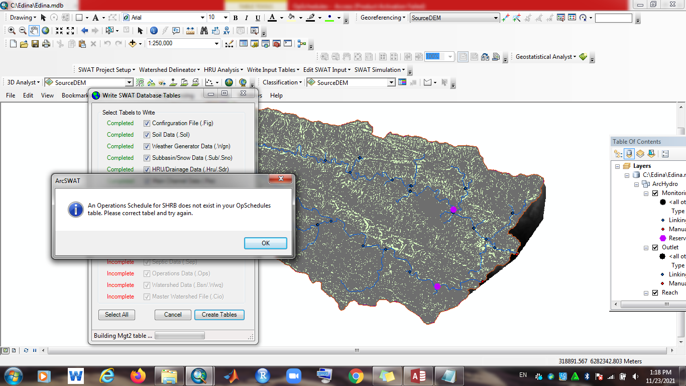
Additionally, I keep getting the following error message during subbasin parameter calculation (last step of watershed delineation) when using the predefined watershed and stream layers in ArcSWAT 2012. I think I closely followed the example files to prepare the watershed and stream layers. Any ideas what might have gone wrong? Your expertise is highly appreciated.
===================
Error Number: 91
Error Message: Object reference not set to an instance of an object
Module name: mSWFlow
Function name: Setparameters
Procedure (error line or description): 6 GRIDCODE=2
====================
I've attached my data.
Many thanks in advance,
Salam

Fariborz Daneshvar

madhukar chavan
I am Madhukar Chavan pursuing Ph. D. (Irrigation and Drainage Engineering) from College of Agricultural Engineering and Technology, Vasantrao Naik Marathwada Krishi Vidyapeeth, Parbhani (Maharashtra State) India. My Ph. D. research entitled "Assessment of area and water allocation in canal command area of Purna irrigation project" with following specific objectives:
1. To assess the water availability in reservoir of Purna irrigation project using SWAT.
2. To analyze the existing water allocation strategies and cropping pattern of study area
3. To estimate the irrigation water demand under rotational supply of irrigation water in canal command area of study area and
4. To suggest the optimum cropping pattern based on performance indicators for the study area
Right now I am preparing all soil data layers required for my study area and run the SWAT model successfully for watershed delineation, reservoir addition and get the water availability as surface runoff.Now I need support for the calibration and validation the model.
& nbsp;
I am digitized the canal network on toposheets with polyline layer shape files and I want to get these shape files as predefined stream dataset and watershed dataset in SWAT, but I am not getting the proper input files. I had also facing the problem while preparing the predefined stream dataset and watershed dataset with ArcSWAT 2012. My research work planned for canal command areas and I want to prepare predefined stream dataset (Canal as stream) with ordering 1, 2, 3, ......... likewise. So I request to you for helping me the same. Your expertise is highly appreciated.
With warm regards
Mr. Chavan Madhukar Lombha
Ph. D. Scholar (IDE)
Department of Irrigation and Drainage Engineering,
College of Agricultural Engineering and Technology,
Vasantrao Naik Marathwada Krishi Vidyapeeth,Parbhani - 431402 (Maharashtra State) India
Mob. No.: 09822742438, 07276817095

Sonam Sandeep Dash

NATALI FABIOLA HOFFMANN CANDIA
Could you pls explainme how to input my own wathersheed?

Natalja C.
Natalja
Dr. Madhukar Chavan
Dr. Chavan Madhukar Lombha
M. Tech. Ph. D. (Agril. Engg.) IDE, ARS/NET (LWME), FINSc
Irrigation and Drainage Engineering,
Assistant Professor (Agricultural Engineering)
MGM, Nanasaheb Kadam College of Agriculture, Gandheli
Dist:- Aurangabad - 431007 (Maharashtra State) India
Mob. No.: 09822742438, 09307627701
--
You received this message because you are subscribed to a topic in the Google Groups "SWAT-user" group.
To unsubscribe from this topic, visit https://groups.google.com/d/topic/swatuser/shqnvE01sFc/unsubscribe.
To unsubscribe from this group and all its topics, send an email to swatuser+u...@googlegroups.com.
To view this discussion on the web visit https://groups.google.com/d/msgid/swatuser/5c17ff63-7902-4cf7-89d5-1f5ec12e482an%40googlegroups.com.

waswa peter
You received this message because you are subscribed to the Google Groups "SWAT-user" group.
To unsubscribe from this group and stop receiving emails from it, send an email to swatuser+u...@googlegroups.com.
To view this discussion on the web visit https://groups.google.com/d/msgid/swatuser/CAJLchi_Z8ATk8-maaSW00Ut0SLopQgR%3D2CZ0xzivVave3hkVWg%40mail.gmail.com.
--
Tel: +27832178825,+256777954835


Sufi
Dr. Madhukar Chavan
Dr. Chavan Madhukar Lombha
M. Tech. Ph. D. (Agril. Engg.) IDE, ARS/NET (LWME), FINSc
Irrigation and Drainage Engineering,
Assistant Professor (Agricultural Engineering)
MGM, Nanasaheb Kadam College of Agriculture, Gandheli
Dist:- Aurangabad - 431007 (Maharashtra State) India
Mob. No.: 09822742438, 09307627701
To view this discussion on the web visit https://groups.google.com/d/msgid/swatuser/1f7a0913-aef3-4a63-98a1-dfde5ec9922an%40googlegroups.com.

seyed mostafa
I'd like to utilize my custom subbasin and stream data in the Watershed Delineation step of ArcSWAT because my study area is relatively flat (south Florida_Harny pond basin). There's a predefined section where I can include the watershed dataset and stream dataset. I've comprehended all the attribute tables for the user-defined watersheds in the ExInputs folder, and I've successfully set up my case study. However, when I try to run the model, I encounter error number 13 (I attached my error pic). I believe I meticulously followed the example files when preparing the watershed and stream layers. Do you have any insights into what could have gone awry? Your expertise would be greatly valued.
I look forward to hearing from you.
My best regards to you,
Seyed