Wrong micro commands
193 views
Skip to first unread message

damian....@gmail.com
Jan 10, 2021, 5:35:44 AM1/10/21
to OsmAnd
Hello,
I noticed that micro commands (or whatever their name is) are wrong and can make you to do mistake.
Having this trip:
Every command look ok, but in OsmAnd it doesn't. The fist command is strange. Because navigation forces you to go left instead of go straight.
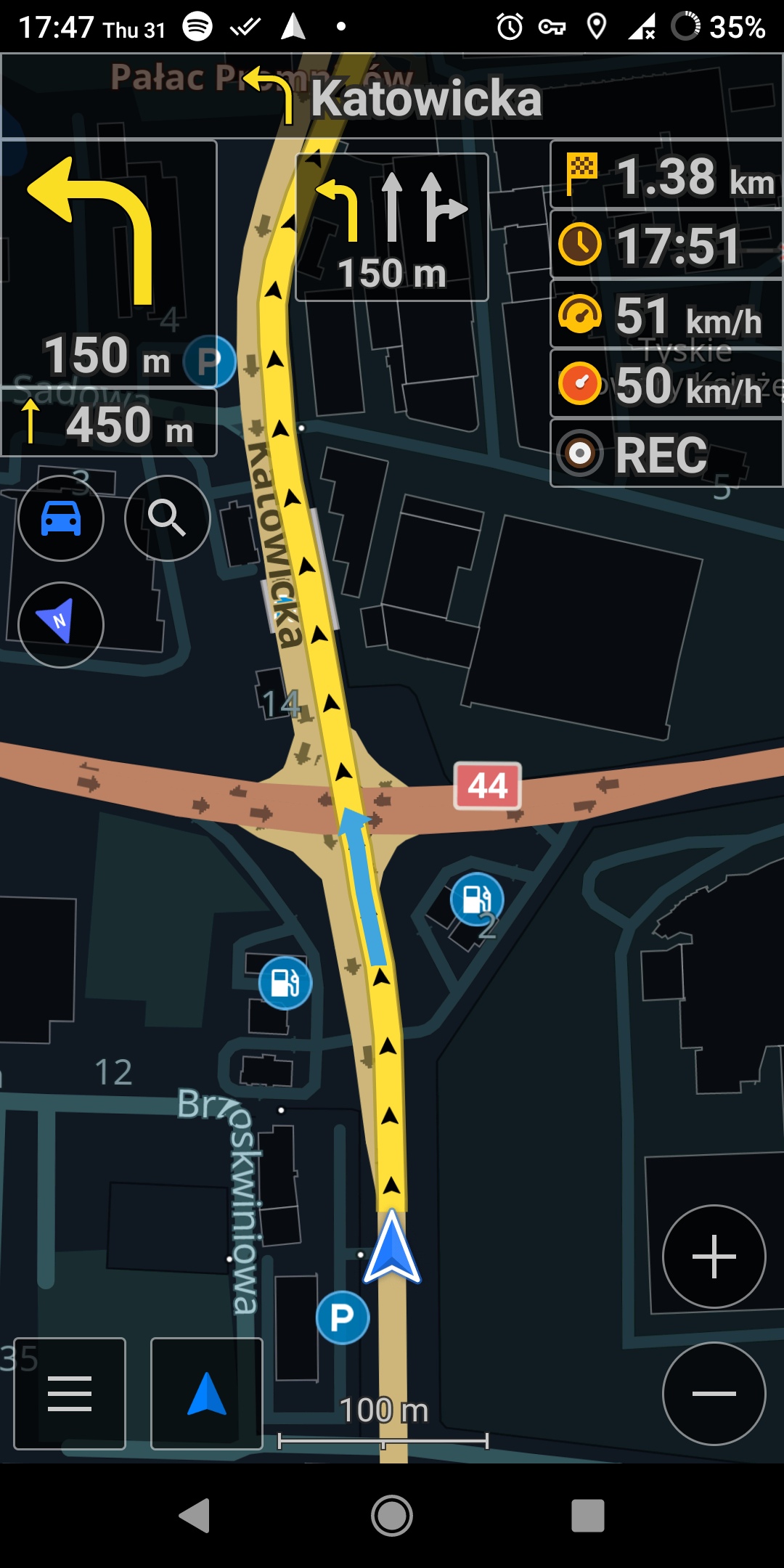
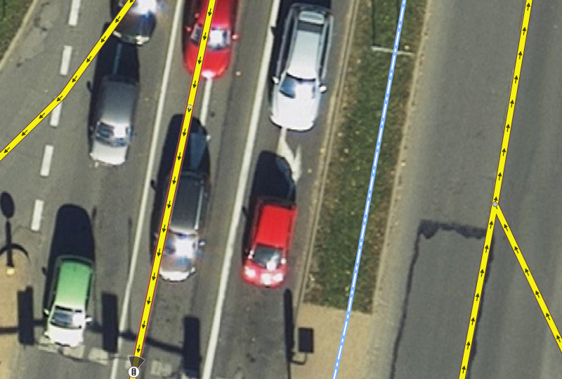
And there is a problem with the second command because, it says that you can use all of three lanes, but in reality it looks like this (Lanes.jpg):
OsmAnd version ~3.8.5

A Thompson
Jan 10, 2021, 11:42:20 PM1/10/21
to OsmAnd
I tried to replicate this (Poland Silesia map 1/1/21, Osmand +3.8.4) taking the from/to coordinates from your OSM link and using the "Simulate navigation" option in OsmAnd but didn't see the same strange directions.
If it helps anyone else to look at this more easily, the route is a 1-minute section from/to:
50.13088, 18.99391
50.13215, 18.99020

Tom Crocker
Jan 11, 2021, 3:02:10 AM1/11/21
to OsmAnd
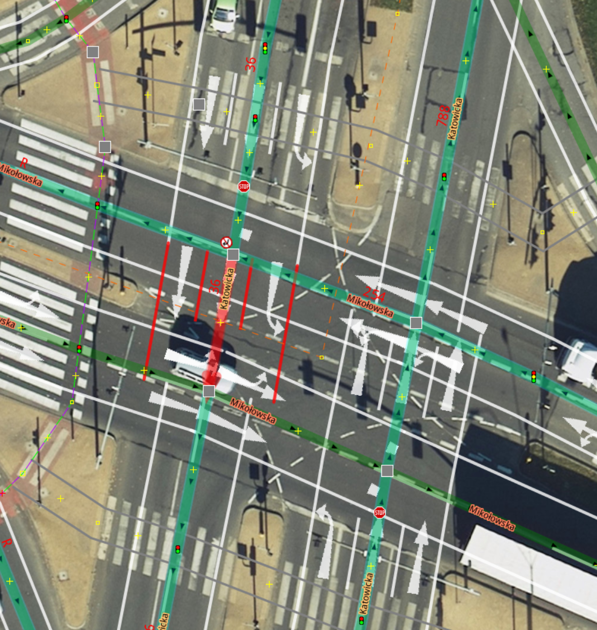
The route plotted in the link seems to be on the other road to the one in the screenshots, which is along Katowicka, north to south.
--
You received this message because you are subscribed to the Google Groups "OsmAnd" group.
To unsubscribe from this group and stop receiving emails from it, send an email to osmand+un...@googlegroups.com.
To view this discussion on the web visit https://groups.google.com/d/msgid/osmand/2557465b-f159-40f2-9f65-7ccbd1c801e8n%40googlegroups.com.
damian....@gmail.com
Jan 18, 2021, 4:05:16 AM1/18/21
to OsmAnd
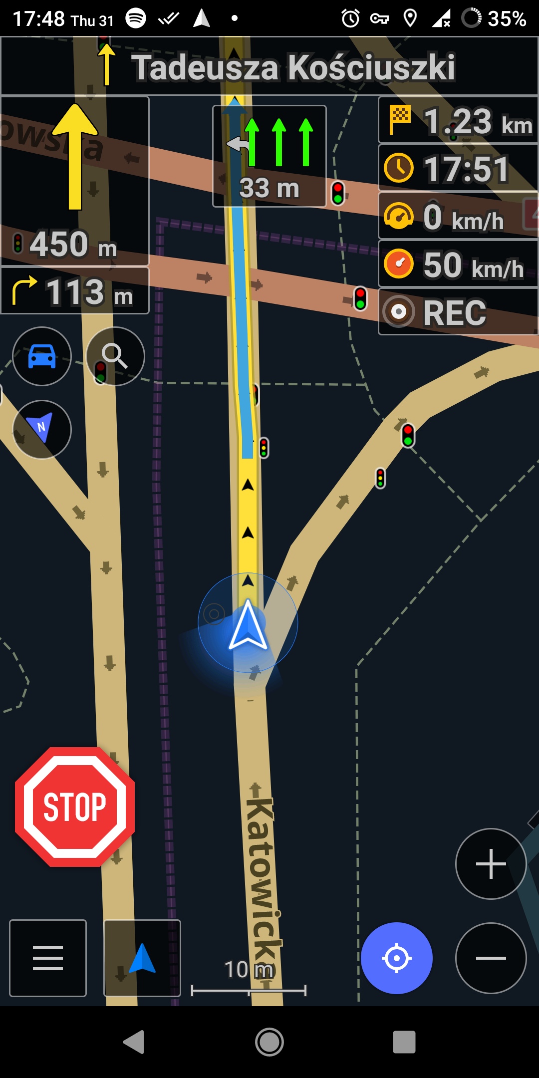
Yes, you're right. Here is the correct route:
Tom Crocker
Jan 19, 2021, 2:27:15 PM1/19/21
to OsmAnd
Okay, so I tried the simulate journey option as Andy suggested and got the same messages as you. I suspect the problem with the left turn lane from Katowicka to Mikolowska is that the turn lanes end before the left turn, where the lane going right crosses.
(the bit between the ways should be tagged as the bit before it,
turn:lanes=
through;left|through|through)
I can't understand why the other junction says to do a u-turn to go through.
Tom
To view this discussion on the web visit https://groups.google.com/d/msgid/osmand/ba342794-8642-4a85-a9f8-56fdd697b5e7n%40googlegroups.com.
Message has been deleted
damian....@gmail.com
Feb 6, 2021, 12:46:57 PM2/6/21
to OsmAnd
Hello,
1.
I noticed that this way: https://www.openstreetmap.org/way/342107973 has such property
turn:lanes=through;left|through|through
It looks like an outdated information in maps according to photo provided by me.
So OsmAnd provided correct micro instruction.
So the correct property should be:
turn:lanes=left|through|through
If somebody confirm it I will fix it.
2.
This way https://www.openstreetmap.org/way/246174080 has such property:
```
turn:lanes=left|through|through;right
```
But I don't understand why OsmAnd says that I need to turn left to go though along the Katowicka in this case:
Tom Crocker
Feb 6, 2021, 1:13:27 PM2/6/21
to OsmAnd
1. I don't know Polish traffic laws but assuming a left arrow, and two up arrows means only left and only straight on for the other two then yes, except note that the road is split in the wrong place, or at least, the next section of road also needs the same lanes until the actual left turn.
2. I'm not sure how osmand should handle this but since there is no left turn and the lane after is tagged through I expect that's what it's targeting. I'd fix the problems and see if it works then.
To view this discussion on the web visit https://groups.google.com/d/msgid/osmand/00f54ba7-6878-4321-9e41-599a3da1a8fdn%40googlegroups.com.

Xavier
Feb 6, 2021, 1:25:51 PM2/6/21
to OsmAnd
>I noticed that this way: https://www.openstreetmap.org/way/342107973 has
>such property
>```
>turn:lanes=through;left|through|through
>```
>It looks like an outdated information in maps according to photo provided
>by me.
None of the available satelitte imagery in JOSM is clear enough for me
>such property
>```
>turn:lanes=through;left|through|through
>```
>It looks like an outdated information in maps according to photo provided
>by me.
to offer advice on what /should/ likely be marked there.
The OpenStreetMap Wiki page that defines the contents of the turn:lanes
key is here: https://wiki.openstreetmap.org/wiki/Key:turn:lanes
You may wish to refer to the definitions as you decide what you believe
should be correct. Do note that OpenStreetMap has a *strict* rule of
"do not map for the renderer" (which also in large part applies to "the
router" as well).
I.e., OpenStreetMap (OSM) desires their map data to accurately reflect the
*on the ground* condition of the road in that intersection. If a map
renderer, or a route router, produces incorrect data, but the master
map data is correct per OSM's definitions, then OSM considers that a
bug in the render or routing engine, not a data problem for OSM.
For the above key (turn:lanes=through;left|through|through) the
"through;left" tag says that the left most lane (looking in the
direction in which the OSM way points) is labeled with a lane marking
arrow that shows both "straight through" travel, and "left turn"
travel. I.e., this image from the OSM Wiki page I reference above:
https://wiki.openstreetmap.org/w/images/thumb/9/95/Turn-left-through.png/50px-Turn-left-through.png
>So OsmAnd provided correct micro instruction.
>
>So the correct property should be:
>```
>turn:lanes=left|through|through
>```
>If somebody confirm it I will fix it.
arrow of a left turn only (no straight through travel) I.e., an arrow
of this type from the OSM Wiki page:
https://wiki.openstreetmap.org/w/images/thumb/4/4a/Richtungspfeil_Links.jpg/50px-Richtungspfeil_Links.jpg
The correct choice for OSM depends upon how the lane is marked/signed
on the ground in this intersection. As none of the satellite images
in JOSM are good enough for me to see any lane markings, I cannot
suggesst anything based on the satellite images.
If you travel through this intersection, then the next time through,
make note of how the lanes are marked, and then verify the OSM tagging,
using the Wiki page as a reference, correctly represents the markings
on the ground (i.e., painted on the lanes or signed on signage).
If OSM's tags differ from the signage -- then correcting OSM to match
the current on the ground signage is proper.
However, if OSM's tags match exactly the signage -- then modifying
OSM's tags would be a violation of OSM's rules.
>
>
>This way https://www.openstreetmap.org/way/246174080 has such property:
>```
>turn:lanes=left|through|through;right
>```
https://wiki.openstreetmap.org/w/images/thumb/d/d4/Turn-through-right.png/50px-Turn-through-right.png
And whether that is correct is again not something I can offer an
opinion on given the low quality of the JOSM satellite images in this
area.
Tom Crocker
Feb 6, 2021, 2:06:12 PM2/6/21
to OsmAnd
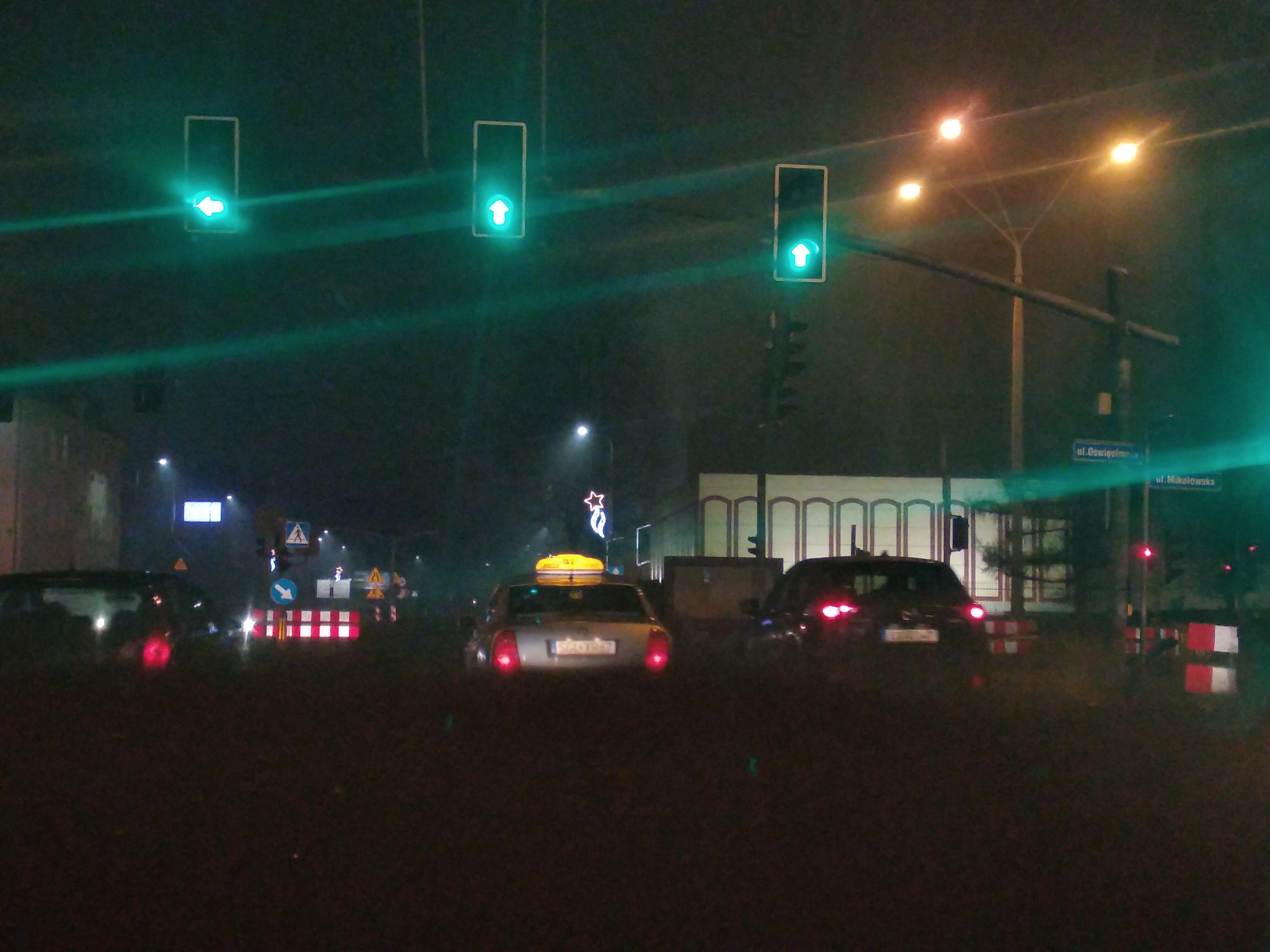
Xavier, a photo of the traffic lights was provided showing a left arrow and two straight on arrows, and it's okay to use traffic lights, the only questions would be whether there are additional lane markings to justify tagging before the traffic lights, and the meaning of those traffic lights in Poland.
--
You received this message because you are subscribed to the Google Groups "OsmAnd" group.
To unsubscribe from this group and stop receiving emails from it, send an email to osmand+un...@googlegroups.com.
To view this discussion on the web visit https://groups.google.com/d/msgid/osmand/20210206182545.GQ2001%40d820.dp100.com.
Xavier
Feb 6, 2021, 4:39:11 PM2/6/21
to OsmAnd
Somehow the photo is no longer attached to the messages I have.
But only a left arrow on the left lane would say that the current
"through;left" is possibly incorrect and the suggested change to simply
"left" is correct per the markings on the ground.
In any case, the correct tagging in OSM is that which will correctly
represent what is actually marked on the intersection (in combination
with what those marks mean in Poland). If the tagging is correct per
the markings, and OSMAnd still gives bad directions, then the issue
becomes one for the OSMAnd devs to investigate.
>To view this discussion on the web visit https://groups.google.com/d/msgid/osmand/CAHmUbmd5DyS2_4m5BZFheqnHeyd9J4GLushf76V37BRXEO94uw%40mail.gmail.com.
But only a left arrow on the left lane would say that the current
"through;left" is possibly incorrect and the suggested change to simply
"left" is correct per the markings on the ground.
In any case, the correct tagging in OSM is that which will correctly
represent what is actually marked on the intersection (in combination
with what those marks mean in Poland). If the tagging is correct per
the markings, and OSMAnd still gives bad directions, then the issue
becomes one for the OSMAnd devs to investigate.
Tom Crocker
Feb 7, 2021, 8:50:51 AM2/7/21
to OsmAnd
I agree Xavier. In this case the photo has a left arrow traffic light in the left hand lane.
To view this discussion on the web visit https://groups.google.com/d/msgid/osmand/20210206213908.GR2001%40d820.dp100.com.
damian....@gmail.com
Mar 20, 2021, 9:30:17 AM3/20/21
to OsmAnd
Sorry for late response.
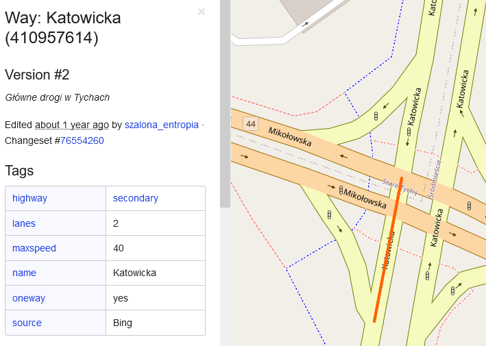
First issue:
I found that imagery from: Geoportal 2: high resolution confirms that the most left lane allows to only turn left. I don't know how old is the imagery from Geoportal 2, so to be sure I will take photo of this intersection and fix it.
I attached the screenshot from Geoportal from osm web editor.
Second issue:
The Geoportal 2 imaginery is available in web editor of osm.
First issue:
I found that imagery from: Geoportal 2: high resolution confirms that the most left lane allows to only turn left. I don't know how old is the imagery from Geoportal 2, so to be sure I will take photo of this intersection and fix it.
I attached the screenshot from Geoportal from osm web editor.
Second issue:
Tom, you assume that fixing the first issue probably will fix the second issue?
Ok, I will check it after fixing the first problem.
Next week I will get photos of this intersection and provide them to be 100% sure that there is a bug in Osm data.
Tom Crocker
Mar 20, 2021, 7:47:51 PM3/20/21
to OsmAnd
2nd issue. Basically I don't know, but until the data makes sense we can't expect osmand to make sense of it, so it seems like the first thing to try. I'm not sure I've been clear enough that I think the main issue is that the tagging isn't correctly placed. It needs to extend all the way to the turn. At the moment, I think it would be reasonable for osmand to assume straight on is 'left' and right is 'straight on' because the tagging doesn't get to the left turn. So evaluating the available roads at the point where the turn should be might match up like I've suggested.
First issue: To be honest, based on your (contemporary?) photo of the traffic light and the aerial imagery it seems reasonable to change the tagging and double check for inconsistency later (I'm not sure what would be appropriate if the traffic lights said one thing and paint another - might need to know Polish road rules but might be best to go with the 'right' answer / ask on osm forums).
Hope that helps
Tom
To view this discussion on the web visit https://groups.google.com/d/msgid/osmand/f4f48e38-36d3-4b82-8f18-66b5905ec340n%40googlegroups.com.
damian....@gmail.com
Mar 28, 2021, 6:28:35 AM3/28/21
to OsmAnd
I changed the tagging. Here is the change https://www.openstreetmap.org/way/342107973.
As far As I am aware, in Poland those signs must be the same.
I will return back to the second issue after I get newest changes from maps.
What do you mean: "It needs to extend all the way to the turn"
Thanks for your involvement.
Tom Crocker
Mar 28, 2021, 7:53:31 AM3/28/21
to OsmAnd
What I meant was that the left turn doesn't get made (at least in node-way routing logic) until you get to the southern, eastbound carriageway of Mikolowska so the lanes and turn lanes needed to extend to there. As it was, they got to the northbound carriageway (where there was no right turn restriction) and the bit that joins the two carriageways, so software evaulating it without making reference to relative angles would assume turn signal left was for the left-most road (straight on) and turn signal straight on was for the next road (right).
I have made the following changes:
Add a right turn restriction and queried whether the same should be done at the other three nodes (I think it should).
Split Katowicka https://www.openstreetmap.org/way/410957614 at the southern point of the intersection and extended the third lane and turn lanes into this.
Made the same split and tagging changes to Mikolowska's southern carriageway (the other two sections of the intersection were already like this).
Can you confirm that the turn restriction seems appropriate - it would be illegal to make the right turn once you got to the crossroads if you had missed the right-turn sliproad?
To view this discussion on the web visit https://groups.google.com/d/msgid/osmand/6131acd2-4053-4b27-aff5-803da601af2fn%40googlegroups.com.
damian....@gmail.com
Apr 9, 2021, 12:19:05 PM4/9/21
to OsmAnd
Yes, if you missed the right-turn, you are not allowed to turn right later.
As I see, you added the right turn restriction to all 4 points in intersection?
You added turning instruction to this lane: https://www.openstreetmap.org/way/923073526 to extend the turn lanes. Am I right?
Sorry for such basic questions, but it's hard topic for me.
I checked this changes on OsmAnd (maps from 1st april) and the data itself. Looks logical for me.
Thank for you contribution!
I think that we can close this topic.
Tom Crocker
Apr 9, 2021, 1:53:20 PM4/9/21
to OsmAnd
Yes, if you missed the right-turn, you are not allowed to turn right later.As I see, you added the right turn restriction to all 4 points in intersection?
I added one right turn restriction for the route you originally described and a query on the other 3 nodes for a local mapper to pick up on.
You added turning instruction to this lane: https://www.openstreetmap.org/way/923073526 to extend the turn lanes. Am I right?
That's right, yes.
Cheers
damian....@gmail.com
Apr 10, 2021, 9:01:48 AM4/10/21
to OsmAnd
piątek, 9 kwietnia 2021 o 19:53:20 UTC+2 tomcroc...@gmail.com napisał(a):
I added one right turn restriction for the route you originally described and a query on the other 3 nodes for a local mapper to pick up on.
Where did you ask the local mapper?
So if eveything looks okay, can we somehow close this thread, or it's not needed?
Tom Crocker
Apr 11, 2021, 4:02:56 AM4/11/21
to OsmAnd
Hi Damian
Yes, we can close this thread.
I put a fixme tag on the nodes themselves: 1226830954 1226830929 177626070, which it seems another mapper (zuicz) has now picked up on. As Xavier said in another thread, it is far more preferable for people with local knowledge to visit the locations and make edits as they have knowledge of the local laws, whether things have changed since the aerial imagery was taken, etc. It can be difficult but I suggest learning to edit would be really useful for you. Tthere is lots of support available on the openstreetmap help site and the Polish forum looks very active: https://forum.openstreetmap.org/viewforum.php?id=23
Cheers
Tom
--
You received this message because you are subscribed to the Google Groups "OsmAnd" group.
To unsubscribe from this group and stop receiving emails from it, send an email to osmand+un...@googlegroups.com.
To view this discussion on the web visit https://groups.google.com/d/msgid/osmand/fbe22f78-b465-4183-bdf9-b8853ee187d0n%40googlegroups.com.
damian....@gmail.com
Apr 11, 2021, 4:35:15 AM4/11/21
to OsmAnd
Thank you for your time and help. I learnt a lot!
Reply all
Reply to author
Forward
0 new messages