TINTOL

Med Outiskt
Hello Luis,
I ask you if there is the manual of TINTOL, I have a problem at the level of NSWING, I make the propagation of tsunami on the first grid but I can't see the propagation in the other levels of grids 1, 2, 3 and 4.
It tells me that the grid does not respect the nesting rules
Although my grids are well prepared with my teacher.
Sincerely,

Joaquim Manuel Freire Luís
Hi,
If the program tells you that grids do not respect the nesting rules, regardless of who made them, believe it.
Have you seen these tutorials?
https://fct-gmt.ualg.pt/mirone/howtos/A_simple_tsunami_propagation_example.pdf
https://fct-gmt.ualg.pt/mirone/howtos/A_nested_grids_approach.pdf
From: mir...@googlegroups.com <mir...@googlegroups.com>
On Behalf Of Med Outiskt
Sent: Wednesday, January 18, 2023 11:08 AM
To: mirone <mir...@googlegroups.com>
Subject: [mirone:545] TINTOL
|
Não costuma receber e-mails de medou...@gmail.com. Saiba por que motivo isto é importante |
--
You received this message because you are subscribed to the Google Groups "mirone" group.
To unsubscribe from this group and stop receiving emails from it, send an email to
mirone+un...@googlegroups.com.
To view this discussion on the web visit
https://groups.google.com/d/msgid/mirone/009aace2-b179-437d-b0eb-f0e16f2c85d7n%40googlegroups.com.
Med Outiskt
Yes, I have consulted these manuals.
Here are the steps I follow on Mirone to prepare my grids: the grid below I transform it into XYZ.dat on surfer and then I do the interpolation on Mirone and I change the resolution like this:
- Layer0.grd : From Gebco 15 Arcsecond data (0.0041667 DD), resampled to 0.004 DD (Geotif to XYZ on surfer then interpolation on Mirone)
After this step I open the Layer0.grd (resolution 0.004 DD), I follow the steps in the manual and when I get here this is what I do :
- I right click on the drawn rectangle and I click again on : Create new nested grid and then I right click on the first rectangle and I choose create blanc grid and then I save the first rectangle and I fill the blank grid with the cut grid (rectangle) and then I make the interpolation with the file of surfer of the grid Layer0 then I change the resolution (by dividing the resolution 0.004 by 5 because I did not change the factor of refinement) and to save it in the form of Layer1 (resolution of 0.0008 DD).
Tell me if this is what I have to do
Thanks a lot
To view this discussion on the web visit https://groups.google.com/d/msgid/mirone/HE1PR0402MB2780E825ECC58A5A2BCCC43CA6C79%40HE1PR0402MB2780.eurprd04.prod.outlook.com.
Joaquim Manuel Freire Luís
Hmm, make it simpler.
Mirone accepts all those formats so for layer 0 just cut a zone of interest and use it (forget that Surfer voyage)
For layer 1 one still can use the grid used in layer 0 to fill it, but for other levels you better have data of higher resolution or else there no real any gain in doing a nested grids modeling. But anyhow, the procedure to follow is that explained in the tutorial.
Can you show an image with the setup of all your nested grids?
From: mir...@googlegroups.com <mir...@googlegroups.com>
On Behalf Of Med Outiskt
Sent: Wednesday, January 18, 2023 3:50 PM
To: mir...@googlegroups.com
Subject: Re: [mirone:546] TINTOL
|
Não costuma receber e-mails de medou...@gmail.com. Saiba por que motivo isto é importante |
Hello again Louis,
Yes, I have consulted these manuals.
Here are the steps I follow on Mirone to prepare my grids: the grid below I transform it into XYZ.dat on surfer and then I do the interpolation on Mirone and I change the resolution like this:
- Layer0.grd : From Gebco 15 Arcsecond data (0.0041667 DD), resampled to 0.004 DD (Geotif to XYZ on surfer then interpolation on Mirone)
After this step I open the Layer0.grd (resolution 0.004 DD), I follow the steps in the manual and when I get here this is what I do :
- I right click on the drawn rectangle and I click again on : Create new nested grid and then I right click on the first rectangle and I choose create blanc grid and then I save the first rectangle and I fill the blank grid with the cut grid (rectangle) and
then I make the interpolation with the file of surfer of the grid Layer0 then I change the resolution (by dividing the resolution 0.004 by 5 because I did not change the factor of refinement) and to save it in the form of Layer1 (resolution of 0.0008 DD).
Tell me if this is what I have to do
Thanks a lot

To view this discussion on the web visit https://groups.google.com/d/msgid/mirone/CADrnEx0-%3DsjFhytWaa8pM6QArPM80bW6gVyqPzXQYJphRa43wg%40mail.gmail.com.
Med Outiskt
Ok for surfer.
I have prepared 3 layers and the last two I will prepare with high resolution data (marine navigation chart, ASTER GDM V3 data, the topographic map ...of the study area). but it's a bit complicated to prepare these last two.
Yes, here are my grids
You received this message because you are subscribed to a topic in the Google Groups "mirone" group.
To unsubscribe from this topic, visit https://groups.google.com/d/topic/mirone/xBfsFh6tWEc/unsubscribe.
To unsubscribe from this group and all its topics, send an email to mirone+un...@googlegroups.com.
To view this discussion on the web visit https://groups.google.com/d/msgid/mirone/HE1PR0402MB278009E766C2226F538A46CFA6C79%40HE1PR0402MB2780.eurprd04.prod.outlook.com.
Joaquim Manuel Freire Luís
With those resolutions and sizes it run for a loooooooooon time.
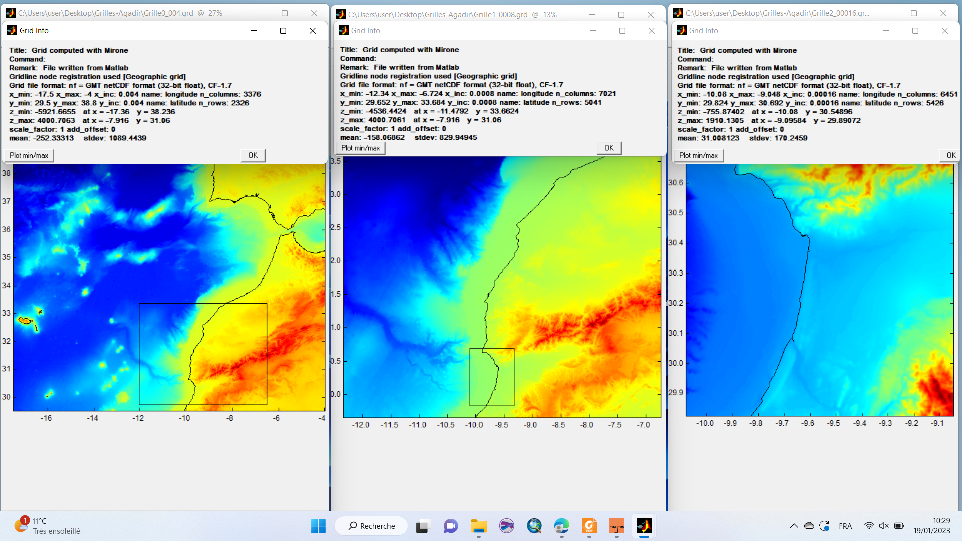
Your layer0 has a grid step of ~400 that certainly came from interpolation because such dataset does not exist at that true resolution. I would use a grid with ~ 1km for layer0. Next your layer1 is too big comparing to layer 2. That brings a big waste in computing time. I would do something like in this figure.
Third, I am sorry to tell you this but ASTER or SRTM grids are no good to do inundation modeling. They vertical errors are just too big. For inundation studies we must have grids with a TRUE resolution of at least 10 meter and where there are no inventions at the shore line.
But you can run your simulation as long as you follow exactly the procedure explained in the tutorial. Remember that you have to create all nesting grids all in on step. You can’t go back and just create or change another level. If the program tells you that nesting grid rues were not followed it’s because you failed to comply with this procedure.

From: mir...@googlegroups.com <mir...@googlegroups.com>
On Behalf Of Med Outiskt
Sent: Thursday, January 19, 2023 10:31 AM
To: mir...@googlegroups.com
Subject: Re: [mirone:548] TINTOL
|
Não costuma receber e-mails de medou...@gmail.com. Saiba por que motivo isto é importante |
Hello Louis,
Ok for surfer.
I have prepared 3 layers and the last two I will prepare with high resolution data (marine navigation chart, ASTER GDM V3 data, the topographic map ...of the study area). but it's a bit complicated to prepare these last two.
Yes, here are my grids

To view this discussion on the web visit https://groups.google.com/d/msgid/mirone/CADrnEx1BdMH7WigN%2BtsUwEr1EM0yfts7Jk1i_cGpviwA39%3Dgmw%40mail.gmail.com.
Med Outiskt
For the flooding we use a DTM with a resolution of 25m with the coastline corrected (corrected from google earth).
For a grid of 10 m no I have not
To view this discussion on the web visit https://groups.google.com/d/msgid/mirone/HE1PR0402MB27800A5FA76F89A1C36A3411A6C49%40HE1PR0402MB2780.eurprd04.prod.outlook.com.
Joaquim Manuel Freire Luís
>So I have to change again the resolution of my bathymetric data from 400m to 1km? and then do the nesting?
No, you don’t have but you’ll see what I mean when you start running the simulation.
> For the flooding we use a DTM with a resolution of 25m with the coastline corrected (corrected from google earth).
The point is, where did that DTM came from? Did it use data at 25 m spacing or reinterpolated from a coarser grid? And again SRTM, ASTER, etc have errors of some meters in vertical. Correcting with GE brings little (to nothing). The problem is how data close to shoreline was obtained? Measured, interpolated (most likely)?
Note, I’m not trying to dissuade you, just trying to make you think in these problems.
To view this discussion on the web visit https://groups.google.com/d/msgid/mirone/CADrnEx1m7Po5J8cmX984Hi6802nanF3hjZLUeDjqGrmDYEQUnA%40mail.gmail.com.
Med Outiskt
the DTM is generated from a topographic map and the bathymetry of GEBCO (with also the navigation marine map) and the coastline have been aggregated to have this DTM with 25 m
To view this discussion on the web visit https://groups.google.com/d/msgid/mirone/HE1PR0402MB27804403819B6CF9DBD3D2C9A6C49%40HE1PR0402MB2780.eurprd04.prod.outlook.com.
Joaquim Manuel Freire Luís
I get mine from GMT’s pages
but with the data that you created a the 400 grid, which, I repeat, is not something that exists at that true resolution, you can also make one grid at 1 km. Or use whatever GEBCO provides you close to that grid spacing.
Do not confuse data resolution with what we get with interpolations. No miracle will increase true data resolution by an operation of interpolation. It may look smoother but that’s all it is.
To view this discussion on the web visit https://groups.google.com/d/msgid/mirone/CADrnEx3-6LbWpd6WQ3u%2Bk%3DQcFCkWrEOH4jMCpuc_ZRvAdD5tAw%40mail.gmail.com.
Med Outiskt
Yes it is by interpolation that I prepared 400m, otherwise at the beginning when I downloaded it on GEBCO this map has a resolution of 416 m
Can I send you privately the grids that I have for my study area to check if they are well prepared?
thank you very much
To view this discussion on the web visit https://groups.google.com/d/msgid/mirone/HE1PR0402MB2780680EF53E225BA6F8AA02A6C59%40HE1PR0402MB2780.eurprd04.prod.outlook.com.
Joaquim Manuel Freire Luís
>Ok thank you very much. Can you tell why you don't use the one from GEBCO ?
Because I like to respect the original authors. Those grids in site I pointed out do that.
>Yes it is by interpolation that I prepared 400m, otherwise at the beginning when I downloaded it on GEBCO this map has a resolution of 416 m
Ah, but for sure they have 30 minutes grids as well.
>Can I send you privately the grids that I have for my study area to check if they are well prepared?
thank you very much
Try first the TNTOL nested grids procedure and test it by trying to run the model (that’s what I would have to do). It works if we follow the procedure. I’ve done that many times.
To view this discussion on the web visit https://groups.google.com/d/msgid/mirone/CADrnEx2PbcaegoofSiUL%2BNpSs6%3DBynioosWEQiaVTE%3Dny%3D6XAw%40mail.gmail.com.
Med Outiskt
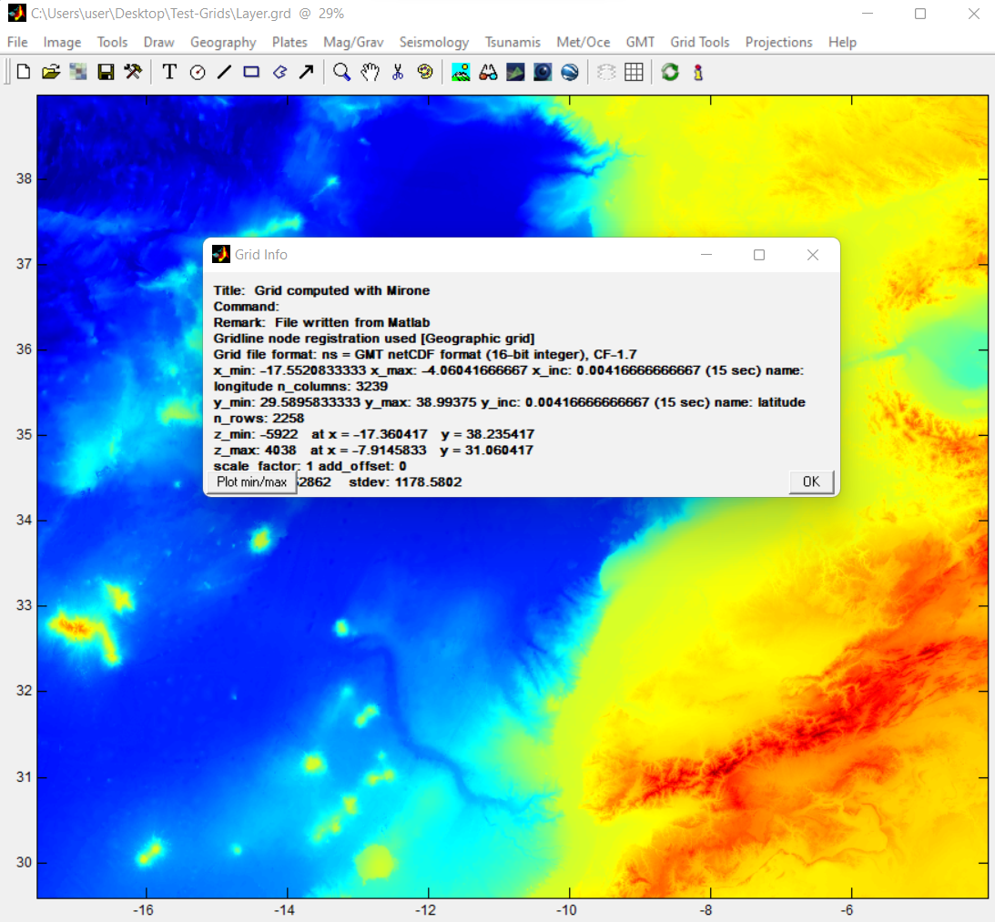
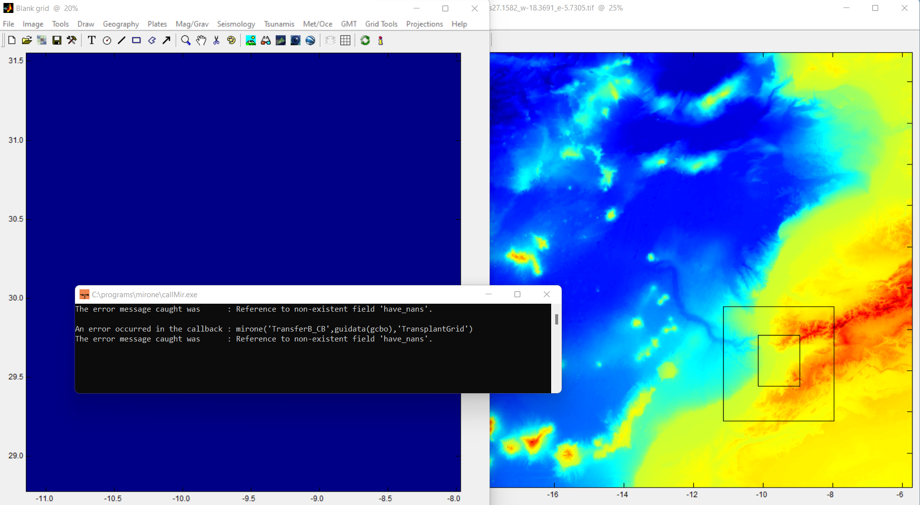
here is how I try to fill it : I right click on the level1 boundary and I click on "Crop grid" and then I save under this format "netCDF format.grd" after in Blanc grid I choose "Transplant 2nd grid" and I click on this saved file but it gives me this error
is this the way to do it or not?
I didn't try to fill it with an XYZ file because you told me last time to forget this surfing trip
Vous pouvez me dire ou il y a l'erreur svp
Med Outiskt
And today when I was redoing the grids I found news here they are below
Please tell me if these are the limits I need to enter in COMCOT
Joaquim Manuel Freire Luís
> I download this grids from GEBCO with this resolution (0.00416)
OK, it’s your exercise. But if it later errors because there is no memory to fill layer1 it’s up to you to solve the problem.
> When I try to fill in the White grid file of my level1, mirone gives me this error
What version are you using? To play safe you should be using the latest version, which is 3.2.3
> I right click on the level1 boundary and I click on "Crop grid" and then I save under this format "netCDF format.grd"
It might work as well but YOU ARE NOT FOLLOWING the tutorial. The tutorial clearly says that you should select the “Create blank grid” option.
From: mir...@googlegroups.com <mir...@googlegroups.com>
On Behalf Of Med Outiskt
Sent: Monday, January 23, 2023 5:57 PM
To: mirone <mir...@googlegroups.com>
Subject: Re: [mirone:557] TINTOL
Hello again sir,
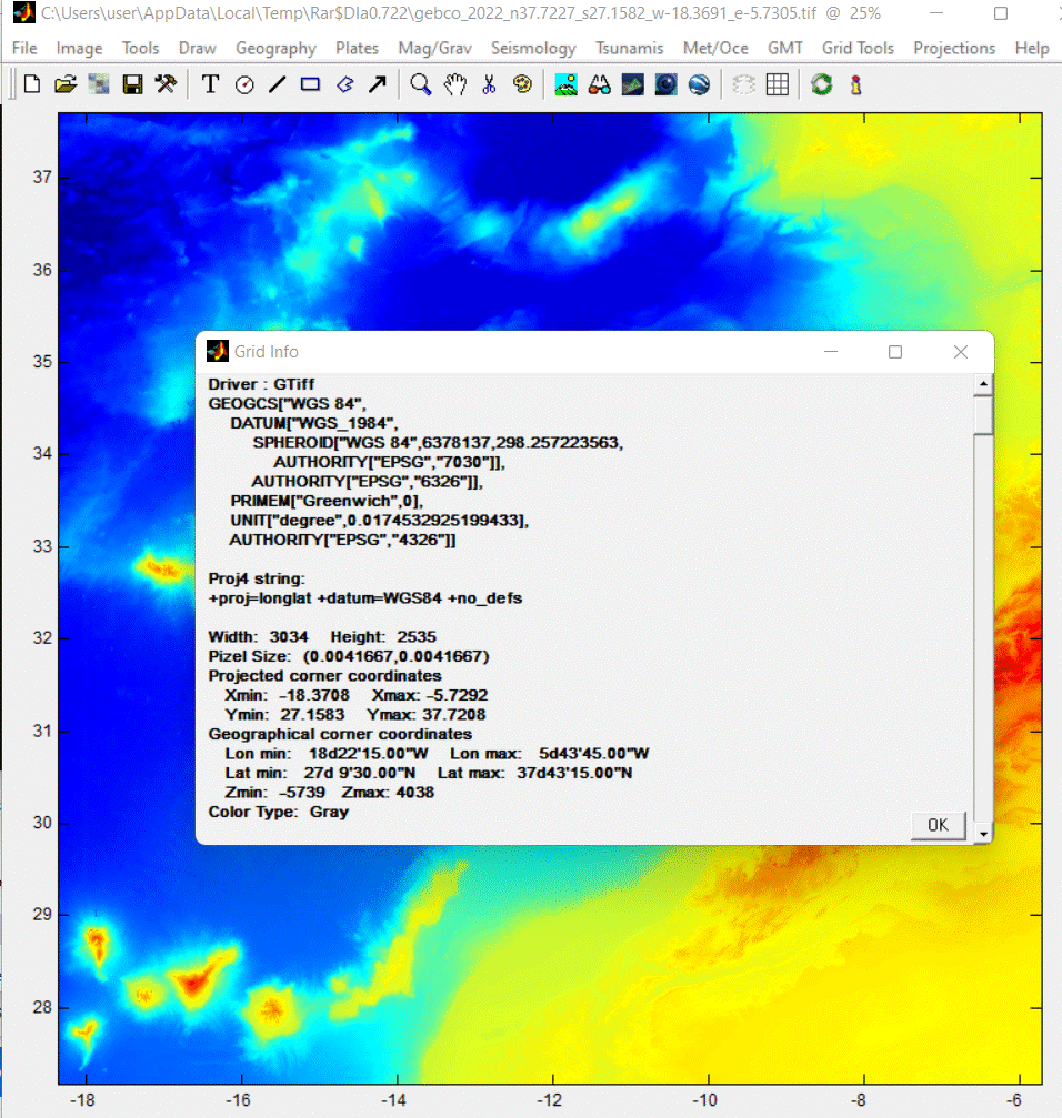
I download this grids from GEBCO with this resolution (0.00416)
When I try to fill in the White grid file of my level1, mirone gives me this error
here is how I try to fill it : I right click on the level1 boundary and I click on "Crop grid" and then I save under this format "netCDF format.grd" after in Blanc grid I choose "Transplant 2nd grid" and I click on this saved file but it gives me this error
is this the way to do it or not?
I didn't try to fill it with an XYZ file because you told me last time to forget this surfing trip
Vous pouvez me dire ou il y a l'erreur svp


To view this discussion on the web visit https://groups.google.com/d/msgid/mirone/b153d704-bcc2-4bfa-915a-0c88c0712782n%40googlegroups.com.
Med Outiskt
>OK, it’s your exercise. But if it later errors because there is no memory to fill layer1 it’s up to you to solve the problem.
>What version are you using? To play safe you should be using the latest version, which is 3.2.3
>It might work as well but YOU ARE NOT FOLLOWING the tutorial. The tutorial clearly says that you should select the “Create blank grid” option.
Joaquim Manuel Freire Luís
>OK, it’s your exercise. But if it later errors because there is no memory to fill layer1 it’s up to you to solve the problem.
How to solve that ?
In a previous mail I pointed you to the GMT site that explains how one can download other grid resolution. But that’s not the only option. GEBCO also ahs other resolutuons.
>What version are you using? To play safe you should be using the latest version, which is 3.2.3
On your wibsite there is 3.2.2 so can you send me the link for 3.2.3 Please
3.2.2 should be OK. Minor updates are done by Mirone itself. See “Help -> Check for updates”
>It might work as well but YOU ARE NOT FOLLOWING the tutorial. The tutorial clearly says that you should select the “Create blank grid” option.
I did it but with which file should I fill the "Blank grid ''?
But that is explained in the tutorial too. Although I understand that the explanation may not be what is expected but really, getting the topo/bathymetric data is a full user task not the program’s.
“It is up to you to create those grids if you want to proceed with this exercise. I cannot do it for because it's your data and I have no data to provide you so PLEASE don't ask me that. But I can show you how to create the layer 1 using the layer 0 grid. While this is ofc a bit of cheating it's not that bad because we are still at a relatively large grid step (for an inundation study point of view) and will serve as an example of what you will have to do, with other data, for higher levels.”
To view this discussion on the web visit https://groups.google.com/d/msgid/mirone/32e421d0-9fce-4c7c-8510-e669444092a5n%40googlegroups.com.
Med Outiskt
And today when I was redoing the grids I found news here they are below
Please tell me if these are the limits I need to enter in COMCOT
Joaquim Manuel Freire Luís
>> In a previous mail I pointed you to the GMT site that explains how one can download other grid resolution.
But that’s not the only option. GEBCO also ahs other resolutuons.
>I didnt find how to download them from GMT, there is data for Newzeland
One need to read a little of the manual but, having GMT installed, it should be just something like this:
gmt grdcut @earth_relief_30s_g -R-20/-5/26/39 -Gmygrid.grd
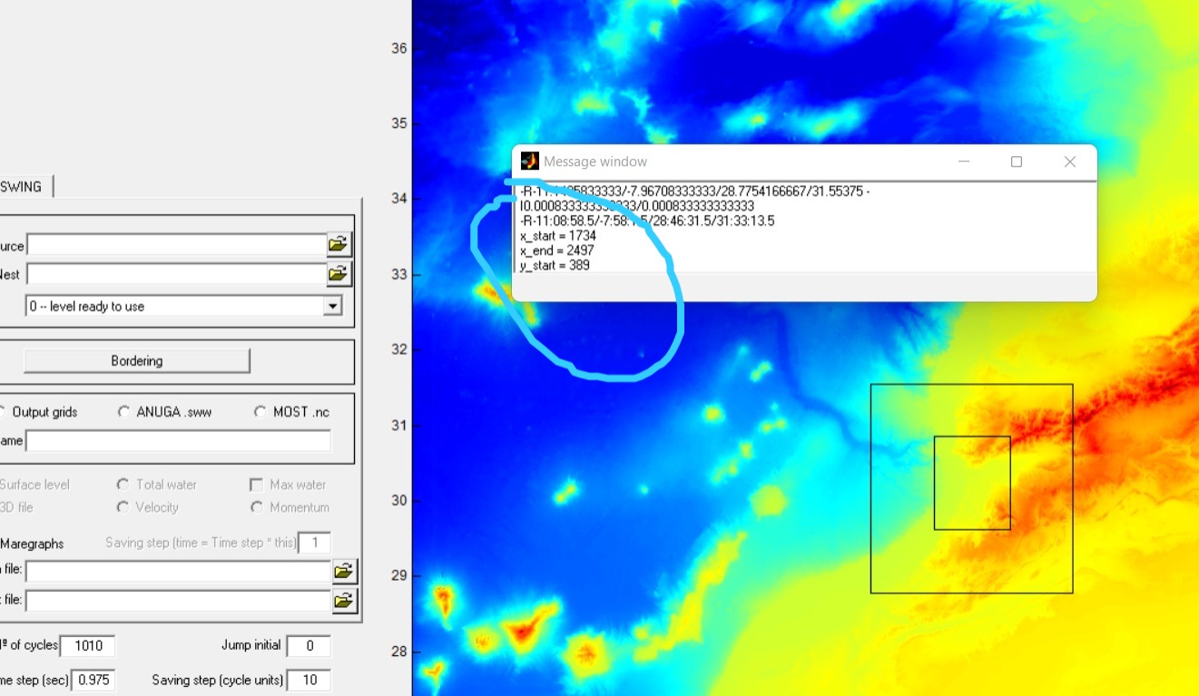
>Please can answer at my previous mail : I try to enter the limits of the grids that I prepared a long time ago but Mirone he tells me the limits are not true in remote that the grid does not respect the nesting rules, and when I integrate them on the COMCOT code it shows me this warning: Layer range beyond the imput data
I’ve not used COMCOT for a long time but yes, those are the exact limits the grid must have and the indices are those that used to be needed to pass to COMCOT.
But I will say it again. If you follow exactly the steps in the tutorial, but using your own data, you’ll get the nested grids with the right characteristics to run the simulation.
To view this discussion on the web visit https://groups.google.com/d/msgid/mirone/1d6c4846-c289-4e55-a9a7-2136b724e506n%40googlegroups.com.
Med Outiskt
I resolved the problem with the grids thank you very much
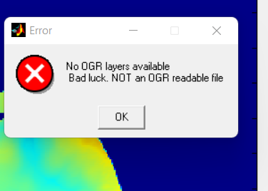
Please how I can superimposed the result of the tsunami on google earth like the max wave height and the short and long_beach. because when I open the results and I click on google earth it shows me this OGR error (look at the screenshot).
Joaquim Manuel Freire Luís
Sorry, forgot to respond.
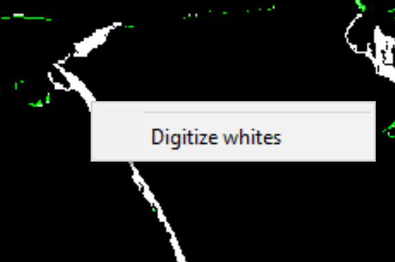
That part is not documented in “How-tos”. And I’m not sure if what I’m going to tell works with the short and long_beach layers produced by Mirone or need to be calculated with command line version of NSWING. Assuming yes, open that layer on right click over an white area and choose “Digitize whites.” This generates a polygon that can be saved on disk (in ascii) or painted and sent to GE.
Note, the white areas show off only if there has been enough inundation do be seen.
To have the wave max height at the beach you must compute the maximum water height grid and interpolate it along the coast line.
From: mir...@googlegroups.com <mir...@googlegroups.com>
On Behalf Of Med Outiskt
Sent: Monday, February 6, 2023 2:34 PM
To: mirone <mir...@googlegroups.com>
Subject: Re: [mirone:564] TINTOL
Hi Joaquim
I resolved the problem with the grids thank you very much
Please how I can superimposed the result of the tsunami on google earth like the max wave height and the short and long_beach. because when I open the results and I click on google earth it shows me this OGR error (look at the screenshot).
- I am using the latest version of Mirone 3.2.2
Thank you.

To view this discussion on the web visit https://groups.google.com/d/msgid/mirone/8c569192-fa33-4096-87d1-990cade165can%40googlegroups.com.
Med Outiskt
I tried with another version of mirone but it does not work as well.
To get the maximum wave height at the beach, you have to calculate the maximum water height grid and interpolate it along the coastline (can you explain to me how to do that and if it is on mirone or other software?).
Thanks.

To view this discussion on the web visit https://groups.google.com/d/msgid/mirone/HE1PR0402MB2780A51D7D5A3234A28DEE81A6D99%40HE1PR0402MB2780.eurprd04.prod.outlook.com.
Joaquim Manuel Freire Luís
Have a look at the other how-to tutorials. For example this one shows how to extract profiles
https://sites.google.com/site/mironehowtos/basic/extract-a-grid-profile
which is what you need to extract wave height on coast.
The other thing is what I feared. The Tintol modules writes grids with 0’s and 255 which are later not recognizes as masks (that have only 0’s and 1’s). A possible solution is to use the “Image -> Binarize Image” to create such a mask grid that later can be automatically digitized. Another alternative is to compute the 254.5 contours, which should delimit the red pixels.
From: mir...@googlegroups.com <mir...@googlegroups.com>
On Behalf Of Med Outiskt
Sent: Thursday, February 16, 2023 11:00 AM
To: mir...@googlegroups.com
Subject: Re: [mirone:565] TINTOL
Hi Joaquim,
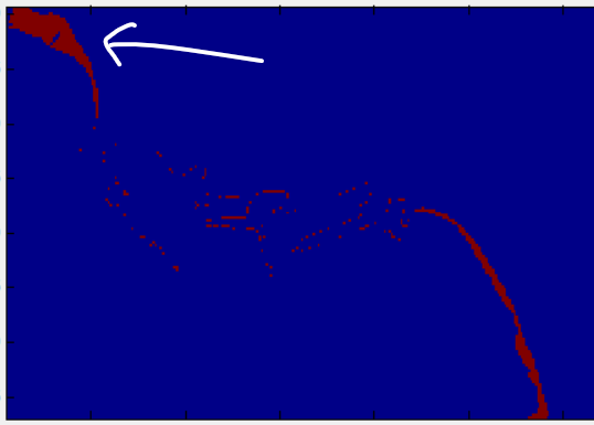
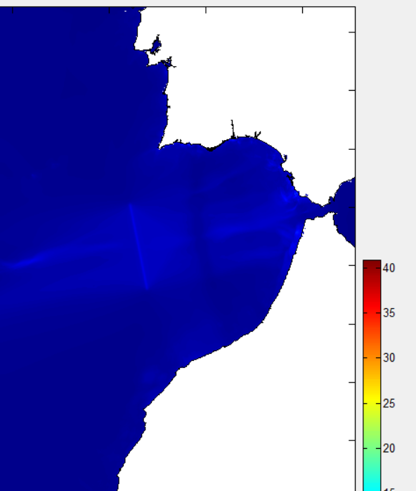
In my case the white areas do not appear (see screenshot) but I think there is a large area that is flooded in the area marked with the arrow or not?
I tried with another version of mirone but it does not work as well.
To get the maximum wave height at the beach, you have to calculate the maximum water height grid and interpolate it along the coastline (can you explain to me how to do that and if it is on mirone or other software?).
Thanks.
To view this discussion on the web visit https://groups.google.com/d/msgid/mirone/CADrnEx3Uy4M2Mmr_tmguyBYGMbHErMYndgYXruaNv70oyW48ag%40mail.gmail.com.
Med Outiskt
I solved the problem of overlay with Google earth.
I just uninstalled Mirone and Google earth and reinstalled it and it works.
Thanks.
To view this discussion on the web visit https://groups.google.com/d/msgid/mirone/HE1PR0402MB2780E1CB6D9369F3B4134DE1A6A09%40HE1PR0402MB2780.eurprd04.prod.outlook.com.
Med Outiskt
I tried "Clip Grid" and "Transplant 2nd grid "but it doesn't work.
If it is not possible then how can I change the color of the Bathy as in the screenshot below.
Thank you so much.
Joaquim Manuel Freire Luís
Outiskt, I’m not sure I understand your question. The example figure you show is not superposing anything.
If you have the bathymetry loaded and next open an empty Mirone figure like this
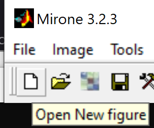
And from it load the deformation grid then under the “Image” menu you can select “Drape” but don’t know if this what you want.
From: mir...@googlegroups.com <mir...@googlegroups.com>
On Behalf Of Med Outiskt
Sent: Thursday, March 2, 2023 12:48 AM
To: mir...@googlegroups.com
Subject: Re: [mirone:568] TINTOL
Hi Joaquim,
Please how can I superimpose the initial deformation with the topography?
I tried "Clip Grid" and "Transplant 2nd grid "but it doesn't work.
If it is not possible then how can I change the color of the Bathy as in the screenshot below.
Thank you so much.

To view this discussion on the web visit https://groups.google.com/d/msgid/mirone/CADrnEx0i%2Br1RJRh%3DfMLvX2z6z8b0h9dtrURA%3DUmLDxtwPE-3xA%40mail.gmail.com.
Med Outiskt
I can't find this Drape option on mirone but it's okey.
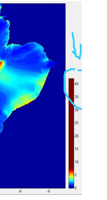
I have another question is that I find after the simulation that the values of the Maximum Highs are not resonable (40 m as in the Screenshot). I think it's because of CFL, how can I solve this because even if I used a Time step of 0.5 the error persists
Thank you for your help.
Joaquim Manuel Freire Luís
The Drape option does not show when the instructions in my previous mail were not followed. It only shows when the operation is possible.
That high value of max height may indicate that the run was starting to diverge but from the figure it seams to be very localized. If you press the “I” icon (last on the right) you get the grid information plus a button saying “Plot min/max”, push it and search for the stars showing the min and max locations.
You can get rid of outliers like this using the tool “Grid Tools -> Clip Grid”
From: mir...@googlegroups.com <mir...@googlegroups.com>
On Behalf Of Med Outiskt
Sent: Saturday, March 11, 2023 8:44 AM
To: mirone <mir...@googlegroups.com>
Subject: Re: [mirone:571] TINTOL
Hello joaquim,
I can't find this Drape option on mirone but it's okey.
I have another question is that I find after the simulation that the values of the Maximum Highs are not resonable (40 m as in the Screenshot). I think it's because of CFL, how can I solve this because even if I used a Time step of 0.5 the error persists
Thank you for your help.

To view this discussion on the web visit https://groups.google.com/d/msgid/mirone/7e7deb22-85b5-4f96-bbc4-d00dddfe603an%40googlegroups.com.
Med Outiskt
I hope you are well.
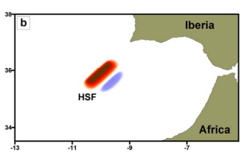
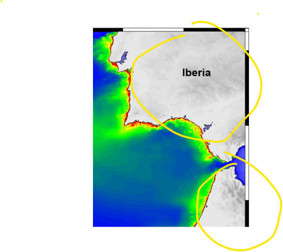
please how can i fill this blank on Mirone like in the attached map ?
I tried with interpolation and transplant 2nd grid but it didn't work
Thank you

Joaquim Manuel Freire Luís
Hi Med,
What grid is this? A max water height?
Note that you don’t want to fill the NaNs with topography because then the water heights would barely be visible since the land heights are much larger.
What you want has to be made with images, one of the water part and the other from land and then blend them together. The Aquamoto tool does that but with individual simulation steps, not with the max water. I’m afraid I don’t recall any other way than do it with GMT and clip operations (using grdimage and pscoast).
Something like this result https://github.com/GenericMappingTools/GMT.jl/blob/master/WL_example_3.pdf
From: mir...@googlegroups.com <mir...@googlegroups.com>
On Behalf Of Med Outiskt
Sent: Wednesday, August 16, 2023 11:40 PM
To: mirone <mir...@googlegroups.com>
Subject: Re: [mirone:573] TINTOL
Hello Joaquim
I hope you are well.
please how can i fill this blank on Mirone like in the attached map ?
I tried with interpolation and transplant 2nd grid but it didn't work
Thank you

To view this discussion on the web visit https://groups.google.com/d/msgid/mirone/e99a0229-0928-46f1-b735-34864c789fcbn%40googlegroups.com.
Med Outiskt
To view this discussion on the web visit https://groups.google.com/d/msgid/mirone/GVXPR04MB992618CA29445AF449E9FC7BA61BA%40GVXPR04MB9926.eurprd04.prod.outlook.com.
Joaquim Manuel Freire Luís
Enviado: 19 de agosto de 2023 13:29
Para: mir...@googlegroups.com <mir...@googlegroups.com>
Assunto: Re: [mirone:574] TINTOL
Med Outiskt
Med Outiskt
Hello Joaquim,
How we can meet the Courant–Friedrichs–Lewy (CFL) numerical stability criterion ? and how we can set the Manning’s roughness coefficient in mirone? what's the value already used in the code NSWING ?
Thank you.