Maxent “NO DATA_value” Error
閲覧: 425 回
最初の未読メッセージにスキップ

Gregory
2019/09/25 22:43:522019/09/25
To: Maxent
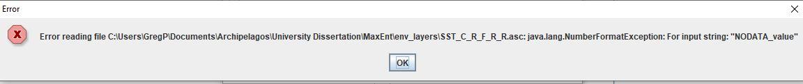
I am trying to run Maxent and I have processed all layers and converted them into .asc files (all layers have the same resolution and extent), there are no 'No Data' areas within the projection extent and all the sample points overlay the raster layers.
However, when trying to run the program, the following error appears:
Java.Lang.NumberFormatException: For Input String: "NO DATA_value"
How do i fix this problem? Thanks for your help!

Rafael Morales Silva
2019/09/25 23:30:192019/09/25
To: max...@googlegroups.com
Hi Gregory,
I think the problem could be the space in your file name "University Dissertation", try without space, instead of a space use underscore "University_Dissertation".
I hope this can help you.
--
You received this message because you are subscribed to the Google Groups "Maxent" group.
To unsubscribe from this group and stop receiving emails from it, send an email to maxent+un...@googlegroups.com.
To view this discussion on the web visit https://groups.google.com/d/msgid/maxent/a1fbc850-8ec3-40ad-8ad1-c7d70eb8d79e%40googlegroups.com.
Gregory Pitcher
2019/09/26 6:53:422019/09/26
To: max...@googlegroups.com
Thank you for your help!
However, I tried fixing this and the same error has occurred.
Any other suggestions as to the source of this problem?
You received this message because you are subscribed to a topic in the Google Groups "Maxent" group.
To unsubscribe from this topic, visit https://groups.google.com/d/topic/maxent/q3aA0IACBaM/unsubscribe.
To unsubscribe from this group and all its topics, send an email to maxent+un...@googlegroups.com.
To view this discussion on the web visit https://groups.google.com/d/msgid/maxent/CAD37f6OkkAxE9TB1828b%2Bk4wTmayBHq_cXcRFjK3up1qtGxqng%40mail.gmail.com.
Rafael Morales Silva
2019/09/27 1:01:562019/09/27
To: max...@googlegroups.com
How did you create your ".asc" files?
To view this discussion on the web visit https://groups.google.com/d/msgid/maxent/CALTMre97agkGmZrv0ESfxtEj0R-A4nsa9seFdOf%2Bf%3DOtkjCMJQ%40mail.gmail.com.
Gregory Pitcher
2019/09/28 10:13:132019/09/28
To: max...@googlegroups.com
I solved the problem. I have been using QGIS to format and process the environmental parameters. When the raster layers are translated into .asc files it alters the nodata_value. I processed the files through an R script and it worked fine.
Thanks for your help.
To view this discussion on the web visit https://groups.google.com/d/msgid/maxent/CAD37f6PT5fyWbiQ-%2Bd1%2B%2BDH_2F-_Q2LWnOvmGDkEqy7JzDjcaA%40mail.gmail.com.

Léa Escoutay
2021/07/24 23:39:182021/07/24
To: Maxent
Hello
I had the same problem; Can you tell me which R script you use to solve it ? And if there is another solution than using R ?
Thank you in advance
Lea
全員に返信
投稿者に返信
転送
新着メール 0 件