Cannot enable WMS Time vizualization

Maël REBOUX
Hello from Britanny
I'm currently trying to set up a map context to show datas with a time dimension.
So :
I set up a WMS layer in GeoServer with a date attribute. The capacities seem OK because I see :
<Dimension name="time" default="current" units="ISO8601">1995-01-01T00:00:00.000Z/2021-01-01T00:00:00.000Z/PT1S</Dimension>
Then I set up a new map context with the Timeline plugin enabled.
Then I load this map context but nothing appens : no timeline.
Big disappointment, I read here this advertise : "Timeline actually works only with WMTS-Multidim extension (WMS time in capabilities is not fully supported). From now on, the layers that the Timeline can manage will be addressed as time layers."
Okay… let's configure a cached version of my layer in the embeded GeoWebCache.
Quite easy. I think all is correct because I see this in the capacities :
<Dimension><ows:Identifier>time</ows:Identifier>
<Default>current</Default>
<Value>1995-01-01T00:00:00.000Z--2021-01-01T00:00:00.000Z</Value>
</Dimension>
The I modify my map to load the WMTS version layer. But still nothing : no timeline.
As I read the plugin documentation, TimeLine requires the playback plugin
https://mapstore.geo-solutions.it/mapstore/docs/api/plugins#plugins.Timeline
https://mapstore.geo-solutions.it/mapstore/docs/api/plugins#plugins.Playback
OK but the doc mention the TimeLine reducer.
Should I always create a specific JSON configuration in the timeline plugin to make it work ?
As I understand the reducer is here only to reduce bounds in case of big datas.
I believed that the time functionality is auto setting when you load a wms time layer. Isn't it ?
Thank you for your advices and help.
Maël REBOUX
Service Information Géographique Rennes Métropole
Chargé de mission données et diffusion
02 99 86 63 71
Twitter : @mael_reboux_ig
https://public.sig.rennesmetropole.fr | https://data.rennesmetropole.fr
Maël REBOUX
Well. I just detected that I get a 400 http error while clicking on one of of the point of my layer.
I don't know if it related to my problem but obviously MS2 create a request beside ?
#GWC demo
/geoserver/gwc/service/wmts?VERSION=1.0.0&LAYER=trp_rout:v_comptage_station_stats
&SERVICE=WMTS
&REQUEST=GetFeatureInfo
&INFOFORMAT=text/html
&FORMAT=image/png
&STYLE=
&TILEMATRIX=EPSG:3857:13
&TILEMATRIXSET=EPSG:3857
&TileCol=4057
&TileRow=2846
&I=6
&J=71
# mapstore
&service=WMTS
&request=GetFeatureInfo
&infoformat=text/plain
&style=point
&tilematrix={"identifier":"EPSG:3857:13","ranges":{"cols":{"min":"4051","max":"4062"},"rows":{"min":"2836","max":"2849"}}}
&tilematrixset=EPSG:3857
&tilecol=4057
&tilerow=2846
&i=6
&j=70
The error
<?xml version="1.0" encoding="UTF-8"?>
<ExceptionReport version="1.1.0" xmlns="http://www.opengis.net/ows/1.1" xmlns:xsi="http://www.w3.org/2001/XMLSchema-instance" xsi:schemaLocation="http://www.opengis.net/ows/1.1 http://geowebcache.org/schema/ows/1.1.0/owsExceptionReport.xsd">
<Exception exceptionCode="InvalidParameterValue" locator="TILEMATRIX">
<ExceptionText>
Unknown TILEMATRIX {"identifier":"EPSG:3857:13","ranges":{"cols":{"min":"4051","max":"4062"},"rows":{"min":"2836","max":"2849"}}}
</ExceptionText>
</Exception>
</ExceptionReport>
De : mapstor...@googlegroups.com [mailto:mapstor...@googlegroups.com] De la part de Maël REBOUX
Envoyé : mardi 16 mars 2021 12:08
À : 'mapstore-users' <mapstor...@googlegroups.com>
Objet : [NEWSLETTER] [mapstore-users] Cannot enable WMS Time vizualization
--
You received this message because you are subscribed to the Google Groups "mapstore-users" group.
To unsubscribe from this group and stop receiving emails from it, send an email to mapstore-user...@googlegroups.com.
To view this discussion on the web visit https://groups.google.com/d/msgid/mapstore-users/007301d71a54%2495c80e10%24c1582a30%24%40rennesmetropole.fr.
Maël REBOUX
Maybe a MS2 : I had to delete my map because it still use a bad tile matrix despite erasing a reloading several times the layer. Should I create an issue ?
So : all new map context with the same layer.
Here the GetFeatureInfo query is better :
/geoserver/gwc/service/wmts?layer=trp_rout:v_comptage_station_stats
&service=WMTS
&request=GetFeatureInfo
&infoformat=text/plain
&style=point
&tilematrix={"identifier":"EPSG:3857:15","ranges":{"cols":{"min":"16204","max":"16250"},"rows":{"min":"11347","max":"11399"}}}
&tilematrixset=EPSG:3857
&tilecol=16232
&tilerow=11375
&i=94
&j=255
But I still get a http 400 bad request answer.
De : mapstor...@googlegroups.com [mailto:mapstor...@googlegroups.com] De la part de Maël REBOUX
Envoyé : mardi 16 mars 2021 14:28
À : mapstor...@googlegroups.com
Objet : [NEWSLETTER] RE:[mapstore-users] Cannot enable WMS Time vizualization
To view this discussion on the web visit https://groups.google.com/d/msgid/mapstore-users/00a401d71a68%2433ce7b90%249b6b72b0%24%40rennesmetropole.fr.

Lorenzo Natali

Maël REBOUX
Thank you for these complete answer Lorenzo.
We don't have the where WMTS-Multidim extension installed in our GeoServer.
I'll install it and come back here after.
De : mapstor...@googlegroups.com [mailto:mapstor...@googlegroups.com] De la part de Lorenzo Natali
Envoyé : mardi 16 mars 2021 18:01
À : mapstore-users <mapstor...@googlegroups.com>
Objet : Re: RE:[mapstore-users] Cannot enable WMS Time vizualization
To view this discussion on the web visit https://groups.google.com/d/msgid/mapstore-users/15bdf8b0-6fca-490d-b09d-120cec286c8cn%40googlegroups.com.
Maël REBOUX
OK. I'm on the way.
I set up a all new (vanilla) GeoServer
And install the jar in the /lib/ directory
Mount a layer
Check the DescribeDomains query --> I've got a <SpaceDomain> answer
So all seems good but…
I cannot acces to my new GS from mapstore2 : nothing just an error message.
Is there something to configure in the LocalConfig.json ?
This server is on my LAN
De : mapstor...@googlegroups.com [mailto:mapstor...@googlegroups.com] De la part de Maël REBOUX
Envoyé : mercredi 17 mars 2021 10:42
À : mapstor...@googlegroups.com
Objet : [NEWSLETTER] RE: RE:[mapstore-users] Cannot enable WMS Time vizualization
To view this discussion on the web visit https://groups.google.com/d/msgid/mapstore-users/00aa01d71b11%24ce5463b0%246afd2b10%24%40rennesmetropole.fr.
Maël REBOUX
OK.
We have updated the proxy.properties file and the hostnameWhitelist
So I can load the WMS and WMTS layer in mapstore.
Now, I have the WMS layaer and WMTS layer loaded in my map.
But nothing happens : no timeline controls :(
And I cannot query the WMTS layer
Is it linked ?
<?xml version="1.0" encoding="UTF-8"?>
<ExceptionReport version="1.1.0" xmlns="http://www.opengis.net/ows/1.1"
xmlns:xsi="http://www.w3.org/2001/XMLSchema-instance"
xsi:schemaLocation="http://www.opengis.net/ows/1.1 http://geowebcache.org/schema/ows/1.1.0/owsExceptionReport.xsd">
<Exception exceptionCode="InvalidParameterValue" locator="TILEMATRIX">
<ExceptionText>Unknown TILEMATRIX </ExceptionText>
</Exception>
</ExceptionReport>
De : mapstor...@googlegroups.com [mailto:mapstor...@googlegroups.com] De la part de Maël REBOUX
Envoyé : jeudi 18 mars 2021 16:23
À : mapstor...@googlegroups.com
Objet : [NEWSLETTER] RE: RE: RE:[mapstore-users] Cannot enable WMS Time vizualization
To view this discussion on the web visit https://groups.google.com/d/msgid/mapstore-users/001d01d71c0a%24943019f0%24bc904dd0%24%40rennesmetropole.fr.
Maël REBOUX
Well.
I read many times your answer : " WMS layer from a GeoServer with WMTS-Multidim plugin installed".
So I load the same layer with 3 differents ways :
- WMS layer from GeoServer WMS
- WMTS layer from the GeoWebCache embedded in GeoServer
- WMS (WMS-C) layer from the GeoWebCache embedded in GeoServer
Anyway : the timeline controls are not present.
Note : I can getFeatureInfo with the WMS-C layer.
What do I miss ?
De : Maël REBOUX [mailto:m.re...@rennesmetropole.fr]
Envoyé : vendredi 19 mars 2021 15:19
À : mapstor...@googlegroups.com
Objet : RE: RE: RE: RE:[mapstore-users] Cannot enable WMS Time vizualization
Lorenzo Natali
Maël REBOUX
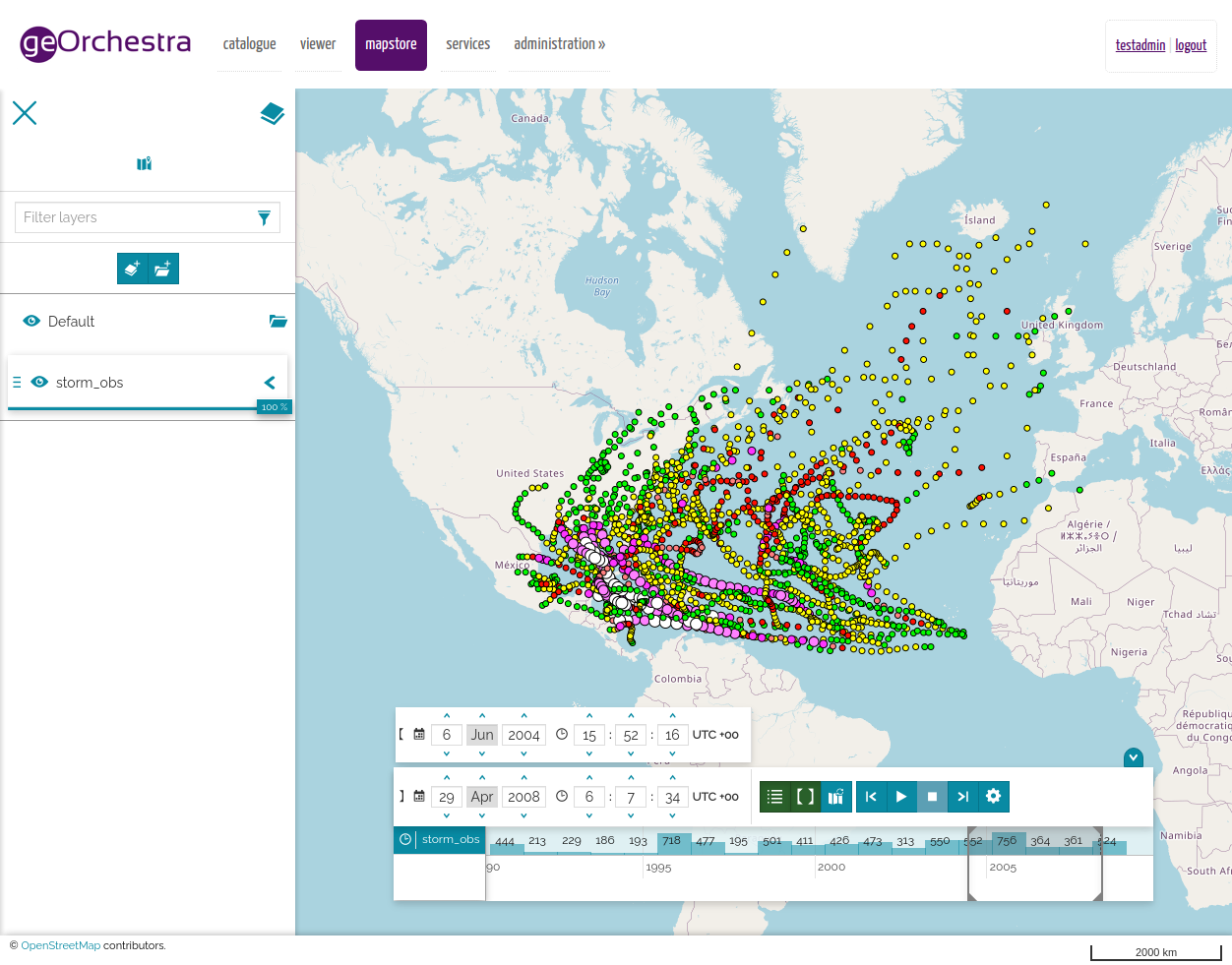
That was it Lorenzo !
Since we have disable third party plugins : the timeline plugins is working.
FYI : one have to set up only a WMS layer. No need to have a WMTS layer.
But I want to make more tests because I saw a different behaviout between our georchestra geoserver and a vanilla geoserver.
Maël
De : mapstor...@googlegroups.com <mapstor...@googlegroups.com> De la part de Lorenzo Natali
Envoyé : mardi 23 mars 2021 13:08
À : mapstore-users <mapstor...@googlegroups.com>
Objet : Re: RE: RE: RE:[mapstore-users] Cannot enable WMS Time vizualization
To view this discussion on the web visit https://groups.google.com/d/msgid/mapstore-users/55a75cb6-7e43-4b92-a9e2-6e0bf7a3f420n%40googlegroups.com.